Display feature layers from various data sources.
Use case
Feature layers, like all layers, are visual representations of data and are used on a map or scene. In the case of feature layers, the underlying data is held in a feature table or feature service.
Feature services are useful for sharing vector GIS data with clients so that individual features can be queried, displayed, and edited. There are various online and offline methods to load feature services.
How to use the sample
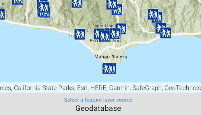
Tap the button on the bottom menu to add feature layers, from different sources, to the map. Pan and zoom the map to view the feature layers.
How it works
- Set the basemap with a
BasemapStyle. - Load a feature layer with a URL.
i. Create aServiceFeatureTablefrom a URL.
ii. Create aFeatureLayerwith the feature table. - Load a feature layer with a portal item.
i. Create aPortalItemwith the portal and item ID.
ii. Create aFeatureLayerwith the portal item and with or without the layer ID. - Load a feature layer with a geodatabase.
i. Instantiate and load aGeodatabaseusing the file name.
ii. Get the feature table from the geodatabase with the feature table's name.
iii. Create aFeatureLayerfrom the feature table. - Load a feature layer with a geopackage.
i. Instantiate and load a geopackage using its file name.
ii. Get the firstGeoPackageFeatureTablefrom theGeoPackage.geoPackageFeatureTablesarray.
iii. Create anFeatureLayerfrom the feature table. - Load a feature layer with a shapefile.
i. Create aShapefileFeatureTableusing the shapefile name.
ii. Create aFeatureLayerfrom the feature table and load it. - Add the feature layer to the map's
OperationalLayers.
Relevant API
- FeatureLayer
- Geodatabase
- GeoPackageFeatureTable
- PortalItem
- ServiceFeatureTable
- ShapefileFeatureTable
Offline data
- Download the data from ArcGIS Online.
- Extract the contents of the downloaded zip file to disk.
- Open your command prompt and navigate to the folder where you extracted the contents of the data from step 1.
- Load the downloaded files using
adb pushto the app.adb push LA_Trails.geodatabase /Android/data/com.esri.arcgisruntime.sample.displayfeaturelayers/files/LA_Trails.geodatabaseadb push AuroraCO.gpkg /Android/data/com.esri.arcgisruntime.sample.displayfeaturelayers/files/AuroraCO.gpkgadb push ScottishWildlifeTrust_reserves/ /Android/data/com.esri.arcgisruntime.sample.displayfeaturelayers/files/ScottishWildlifeTrust_reserves/
| Link | Local Location |
|---|---|
| LA trails geodatabase | /Android/data/com.esri.arcgisruntime.sample.displayfeaturelayers/files/LA_Trails.geodatabase |
| Aurora Colorado geopackage | /Android/data/com.esri.arcgisruntime.sample.displayfeaturelayers/files/AuroraCO.gpkg |
| Scottish Wildlife Trust reserve shapefile | /Android/data/com.esri.arcgisruntime.sample.displayfeaturelayers/files/ScottishWildlifeTrust_reserves/ |
About the data
This sample uses the Naperville damage assessment service, Trees of Portland portal item, Los Angeles Trailheads geodatabase, Aurora, Colorado GeoPackage, and Scottish Wildlife Trust Reserves Shapefile.
The Scottish Wildlife Trust shapefile data is provided from Scottish Wildlife Trust under CC-BY licence. Data Copyright Scottish Wildlife Trust (2022).
Tags
feature, geodatabase, geopackage, layers, service, shapefile, table
Sample Code
/* Copyright 2022 Esri
*
* Licensed under the Apache License, Version 2.0 (the "License");
* you may not use this file except in compliance with the License.
* You may obtain a copy of the License at
*
* http://www.apache.org/licenses/LICENSE-2.0
*
* Unless required by applicable law or agreed to in writing, software
* distributed under the License is distributed on an "AS IS" BASIS,
* WITHOUT WARRANTIES OR CONDITIONS OF ANY KIND, either express or implied.
* See the License for the specific language governing permissions and
* limitations under the License.
*
*/
package com.esri.arcgisruntime.sample.displayfeaturelayers
import android.os.Bundle
import android.util.Log
import android.widget.ArrayAdapter
import android.widget.AutoCompleteTextView
import android.widget.Toast
import androidx.appcompat.app.AppCompatActivity
import com.esri.arcgisruntime.ArcGISRuntimeEnvironment
import com.esri.arcgisruntime.data.GeoPackage
import com.esri.arcgisruntime.data.Geodatabase
import com.esri.arcgisruntime.data.ServiceFeatureTable
import com.esri.arcgisruntime.data.ShapefileFeatureTable
import com.esri.arcgisruntime.layers.FeatureLayer
import com.esri.arcgisruntime.loadable.LoadStatus
import com.esri.arcgisruntime.mapping.ArcGISMap
import com.esri.arcgisruntime.mapping.BasemapStyle
import com.esri.arcgisruntime.mapping.Viewpoint
import com.esri.arcgisruntime.mapping.view.MapView
import com.esri.arcgisruntime.portal.Portal
import com.esri.arcgisruntime.portal.PortalItem
import com.esri.arcgisruntime.sample.displayfeaturelayers.databinding.ActivityMainBinding
import com.esri.arcgisruntime.security.UserCredential
import java.io.File
class MainActivity : AppCompatActivity() {
// enum to keep track of the selected source to display the feature layer
enum class FeatureLayerSource(val menuPosition: Int) {
SERVICE_FEATURE_TABLE(0),
PORTAL_ITEM(1),
GEODATABASE(2),
GEOPACKAGE(3),
SHAPEFILE(4)
}
private val TAG = MainActivity::class.java.simpleName
// keeps track of the previously selected feature layer source
private var previousSource: FeatureLayerSource? = null
private val activityMainBinding by lazy {
ActivityMainBinding.inflate(layoutInflater)
}
private val mapView: MapView by lazy {
activityMainBinding.mapView
}
private val bottomListItems: AutoCompleteTextView by lazy {
activityMainBinding.bottomListItems
}
override fun onCreate(savedInstanceState: Bundle?) {
super.onCreate(savedInstanceState)
setContentView(activityMainBinding.root)
// authentication with an API key or named user is required to
// access basemaps and other location services
ArcGISRuntimeEnvironment.setApiKey(BuildConfig.API_KEY)
// create a map with the BasemapStyle topographic
val map = ArcGISMap(BasemapStyle.ARCGIS_TOPOGRAPHIC)
// set the map to be displayed in the layout's MapView
mapView.map = map
setUpBottomUI()
}
/**
* Load a feature layer with a URL
*/
private fun loadFeatureServiceURL() {
// initialize the service feature table using a URL
val serviceFeatureTable =
ServiceFeatureTable(resources.getString(R.string.sample_service_url)).apply {
// set user credentials to authenticate with the service
credential = UserCredential("viewer01", "I68VGU^nMurF")
// NOTE: Never hardcode login information in a production application
// This is done solely for the sake of the sample
}
// create a feature layer with the feature table
val featureLayer = FeatureLayer(serviceFeatureTable)
val viewpoint = Viewpoint(41.773519, -88.143104, 4000.0)
// set the feature layer on the map
setFeatureLayer(featureLayer, viewpoint)
}
/**
* Load a feature layer with a portal item
*/
private fun loadPortalItem() {
// set the portal
val portal = Portal("https://www.arcgis.com", false)
// create the portal item with the item ID for the Portland tree service data
val portalItem = PortalItem(portal, "1759fd3e8a324358a0c58d9a687a8578")
portalItem.addDoneLoadingListener {
if(portalItem.loadStatus == LoadStatus.LOADED){
// create the feature layer with the item
val featureLayer = FeatureLayer(portalItem)
// set the viewpoint to Portland, Oregon
val viewpoint = Viewpoint(45.5266, -122.6219, 2500.0)
// set the feature layer on the map
setFeatureLayer(featureLayer, viewpoint)
}else{
showError("Error loading portal item: ${portalItem.loadError.message}")
}
}
portalItem.loadAsync()
}
/**
* Load a feature layer with a local geodatabase file
*/
private fun loadGeodatabase() {
// locate the .geodatabase file in the device
val geodatabaseFile = File(getExternalFilesDir(null), "/LA_Trails.geodatabase")
// instantiate the geodatabase with the file path
val geodatabase = Geodatabase(geodatabaseFile.path)
// load the geodatabase
geodatabase.loadAsync()
geodatabase.addDoneLoadingListener {
if (geodatabase.loadStatus == LoadStatus.LOADED) {
// get the feature table with the name
val geodatabaseFeatureTable = geodatabase.getGeodatabaseFeatureTable("Trailheads")
// create a feature layer with the feature table
val featureLayer = FeatureLayer(geodatabaseFeatureTable)
// set the viewpoint to Malibu, California
val viewpoint = Viewpoint(34.0772, -118.7989, 600000.0)
// set the feature layer on the map
setFeatureLayer(featureLayer, viewpoint)
} else {
showError("Error loading geodatabase: ${geodatabase.loadError.message}")
}
}
}
/**
* Load a feature layer with a local geopackage file
*/
private fun loadGeopackage() {
// locate the .gpkg file in the device
val geopackageFile = File(getExternalFilesDir(null), "/AuroraCO.gpkg")
// instantiate the geopackage with the file path
val geoPackage = GeoPackage(geopackageFile.path)
// load the geopackage
geoPackage.loadAsync()
geoPackage.addDoneLoadingListener {
if (geoPackage.loadStatus == LoadStatus.LOADED) {
// get the first feature table in the geopackage
val geoPackageFeatureTable = geoPackage.geoPackageFeatureTables.first()
// create a feature layer with the feature table
val featureLayer = FeatureLayer(geoPackageFeatureTable)
// set the viewpoint to Denver, CO
val viewpoint = Viewpoint(39.7294, -104.8319, 500000.0)
// set the feature layer on the map
setFeatureLayer(featureLayer, viewpoint)
} else {
showError("Error loading geopackage: ${geoPackage.loadError.message}")
}
}
}
/**
* Load a feature layer with a local shapefile file
*/
private fun loadShapefile() {
try {
// locate the shape file in device
val file = File(
getExternalFilesDir(null),
"/ScottishWildlifeTrust_ReserveBoundaries_20201102.shp"
)
// create a shapefile feature table from a named bundle resource
val shapeFileTable = ShapefileFeatureTable(file.path)
// create a feature layer for the shapefile feature table
val featureLayer = FeatureLayer(shapeFileTable)
// set the viewpoint to Scotland
val viewpoint = Viewpoint(56.641344, -3.889066, 6000000.0)
// set the feature layer on the map
setFeatureLayer(featureLayer, viewpoint)
} catch (e: Exception) {
showError("Error loading shapefile: ${e.message}")
}
}
/**
* Sets the map using the [layer] at the given [viewpoint]
*/
private fun setFeatureLayer(layer: FeatureLayer, viewpoint: Viewpoint) {
// clears the existing layer on the map
mapView.map.operationalLayers.clear()
// adds the new layer to the map
mapView.map.operationalLayers.add(layer)
// updates the viewpoint to the given viewpoint
mapView.setViewpoint(viewpoint)
}
private fun showError(message: String?) {
Toast.makeText(this@MainActivity, message, Toast.LENGTH_SHORT).show()
Log.e(TAG, message.toString())
}
/**
* Sets up the bottom UI selector to switch between
* different ways to load a feature layers
*/
private fun setUpBottomUI() {
// create an adapter with the types of feature layer
// sources to be displayed in menu
val adapter = ArrayAdapter(
this,
android.R.layout.simple_list_item_1,
resources.getStringArray(R.array.feature_layer_sources)
)
bottomListItems.apply {
// populate the bottom list with the feature layer sources
setAdapter(adapter)
// click listener when feature layer source is selected
setOnItemClickListener { _, _, i, _ ->
// get the selected feature layer source
val selectedSource = FeatureLayerSource.values().find { it.menuPosition == i }
// check if the same feature is selected
if (previousSource != null && (previousSource == selectedSource)) {
// same feature layer selected, return
return@setOnItemClickListener
}
// set the feature layer source using the selected source
when (selectedSource) {
FeatureLayerSource.SERVICE_FEATURE_TABLE -> loadFeatureServiceURL()
FeatureLayerSource.PORTAL_ITEM -> loadPortalItem()
FeatureLayerSource.GEODATABASE -> loadGeodatabase()
FeatureLayerSource.GEOPACKAGE -> loadGeopackage()
FeatureLayerSource.SHAPEFILE -> loadShapefile()
}
// update the previous feature layer source
previousSource = selectedSource
}
}
}
override fun onPause() {
mapView.pause()
super.onPause()
}
override fun onResume() {
super.onResume()
mapView.resume()
// update UI if screen rotates or resumes
setUpBottomUI()
}
override fun onDestroy() {
mapView.dispose()
super.onDestroy()
}
}