Display KML from a URL, portal item, or local KML file.
Use case
Keyhole Markup Language (KML) is a data format used by Google Earth. KML is popular as a transmission format for consumer use and for sharing geographic data between apps. You can use Runtime to display KML files, with full support for a variety of features, including network links, 3D models, screen overlays, and tours.
How to use the sample
Use the overflow menu to select a source. A KML file from that source will be loaded and displayed in the map.
How it works
- To create a KML layer from a URL, create a
KmlDatasetusing the URL to the KML file. Then pass the data set to theKmlLayerconstructor. - To create a KML layer from a portal item, construct a
PortalItemwith a portal and the KML portal item. Pass the portal item to theKmlLayerconstructor. - To create a KML layer from a local file, create a
KmlDatasetusing a path to the local KML file in external storage. Then pass the data set to theKmlLayerconstructor. - Add the layer as an operational layer to the map with
map.operationalLayers.add(kmlLayer).
Relevant API
- KmlDataset
- KmlLayer
Offline Data
- Download the data from ArcGIS Online.
- Open your command prompt and navigate to the folder where you extracted the contents of the data from step 1.
- Push the data into the scoped storage of the sample app:
adb push US_State_Capitals.kml /Android/data/com.esri.arcgisruntime.sample.displaykml/files/US_State_Capitals.kml
About the data
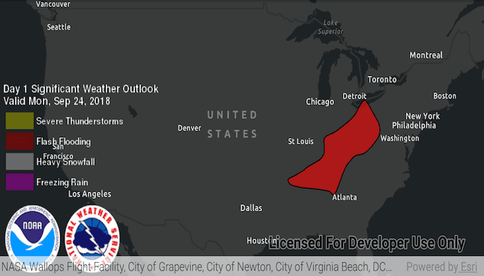
This sample displays three different KML files:
- From URL - this is a map of the significant weather outlook produced by NOAA/NWS. It uses KML network links to always show the latest data.
- From LOCAL_FILE - this is a map of U.S. state capitals. It doesn't define an icon, so the default pushpin is used for the points.
- From PORTAL_ITEM - this is a map of U.S. states.
Tags
keyhole, KML, KMZ, OGC
Sample Code
MainActivity.kt
/*
* Copyright 2020 Esri
*
* Licensed under the Apache License, Version 2.0 (the "License");
* you may not use this file except in compliance with the License.
* You may obtain a copy of the License at
*
* http://www.apache.org/licenses/LICENSE-2.0
*
* Unless required by applicable law or agreed to in writing, software
* distributed under the License is distributed on an "AS IS" BASIS,
* WITHOUT WARRANTIES OR CONDITIONS OF ANY KIND, either express or implied.
* See the License for the specific language governing permissions and
* limitations under the License.
*
*/
package com.esri.arcgisruntime.sample.displaykml
import android.os.Bundle
import android.util.Log
import android.view.Menu
import android.view.MenuItem
import android.view.View
import android.widget.ProgressBar
import android.widget.Toast
import androidx.appcompat.app.AppCompatActivity
import com.esri.arcgisruntime.ArcGISRuntimeEnvironment
import com.esri.arcgisruntime.layers.KmlLayer
import com.esri.arcgisruntime.loadable.LoadStatus
import com.esri.arcgisruntime.loadable.Loadable
import com.esri.arcgisruntime.mapping.ArcGISMap
import com.esri.arcgisruntime.mapping.BasemapStyle
import com.esri.arcgisruntime.mapping.Viewpoint
import com.esri.arcgisruntime.mapping.view.MapView
import com.esri.arcgisruntime.ogc.kml.KmlDataset
import com.esri.arcgisruntime.portal.Portal
import com.esri.arcgisruntime.portal.PortalItem
import com.esri.arcgisruntime.sample.displaykml.databinding.ActivityMainBinding
class MainActivity : AppCompatActivity() {
private val TAG: String = MainActivity::class.java.simpleName
private val activityMainBinding by lazy {
ActivityMainBinding.inflate(layoutInflater)
}
private val mapView: MapView by lazy {
activityMainBinding.mapView
}
private val progressIndicator: ProgressBar by lazy {
activityMainBinding.progressIndicator
}
override fun onCreate(savedInstanceState: Bundle?) {
super.onCreate(savedInstanceState)
setContentView(activityMainBinding.root)
// authentication with an API key or named user is required to access basemaps and other
// location services
ArcGISRuntimeEnvironment.setApiKey(BuildConfig.API_KEY)
// show progress indicator when app starts
progressIndicator.visibility = View.VISIBLE
// create a map with the dark gray canvas basemap
val map = ArcGISMap(BasemapStyle.ARCGIS_DARK_GRAY)
// set the map to the map view
mapView.map = map
mapView.setViewpoint(Viewpoint(39.0, -98.0, 100000000.0))
// prompt user to make a KML source selection when the app has loaded
map.addDoneLoadingListener {
if (map.loadStatus == LoadStatus.LOADED) {
Toast.makeText(applicationContext, R.string.user_prompt, Toast.LENGTH_LONG).show()
// hide progress indicator once map has loaded
progressIndicator.visibility = View.GONE
}
}
}
/**
* Shows progress indicator if the KML Layer is loading, clears all operational layers and adds
* the KML layer to the map as an operational layer.
*
* @param kmlLayer to add to the map
*/
private fun display(kmlLayer: KmlLayer) {
// show progress indicator if kml dataset is loading
progressIndicator.visibility = View.VISIBLE
// hide progress indicator when kml dataset has loaded
kmlLayer.addDoneLoadingListener {
if (kmlLayer.loadStatus == LoadStatus.LOADED) {
progressIndicator.visibility = View.GONE
}
}
// clear operational layers before adding the KML layer to the map
val operationalLayers = mapView.map.operationalLayers
operationalLayers.clear()
operationalLayers.add(kmlLayer)
}
/**
* Display a KML layer from a URL.
*/
private fun changeSourceToURL() {
// create a KML data set from a URL
val kmlDataset = KmlDataset(getString(R.string.noaa_weather_kml_url))
// create a KML layer created from the KML data set and display it on the map
val kmlLayer = KmlLayer(kmlDataset)
display(kmlLayer)
// report layers if failed to load
reportErrors(kmlLayer, "Failed to load KML layer from URL")
}
/**
* Display a KML layer from a portal item.
*/
private fun changeSourceToPortalItem() {
// create a portal to ArcGIS Online
val portal = Portal(getString(R.string.arcgis_online_url))
// create a portal item from a KML item id
val portalItem = PortalItem(portal, getString(R.string.kml_item_id))
// a KML layer created from an ArcGIS Online portal item
val kmlLayer = KmlLayer(portalItem)
display(kmlLayer)
// report layers if failed to load
reportErrors(kmlLayer, "Failed to load KML layer from portal item")
}
/**
* Display a kml layer from external storage.
*/
private fun changeSourceToFileExternalStorage() {
// get the data set stored locally in device external storage
val file = getExternalFilesDir(null)?.path + getString(R.string.kml_path)
val kmlDataset = KmlDataset(file)
// create a KML layer from the locally stored data set
val kmlLayer = KmlLayer(kmlDataset)
display(kmlLayer)
// report layers if failed to load
reportErrors(kmlLayer, "Failed to load kml data set from external storage: $file ")
}
/**
* Reports any loading errors of the KML datasets
*
* @param kmlData any loadable containing a kml data set e.g. KmlDataset or KmlLayer
* @param string the error message to display
*/
private fun reportErrors(kmlData: Loadable, string: String) {
// report errors if failed to load
kmlData.addDoneLoadingListener {
if (kmlData.loadStatus != LoadStatus.LOADED) {
// remove the progress indicator
progressIndicator.visibility = View.GONE
// report the error
val error = string + kmlData.loadError.message
Toast.makeText(this, error, Toast.LENGTH_LONG).show()
Log.e(TAG, error)
}
}
}
override fun onCreateOptionsMenu(menu: Menu?): Boolean {
menuInflater.inflate(R.menu.kml_sources, menu)
return super.onCreateOptionsMenu(menu)
}
override fun onOptionsItemSelected(item: MenuItem): Boolean {
when (item.itemId) {
R.id.kmlFromUrl -> changeSourceToURL()
R.id.kmlFromPortal -> changeSourceToPortalItem()
R.id.kmlFromExternalStorage -> changeSourceToFileExternalStorage()
else -> return super.onOptionsItemSelected(item)
}
return true
}
override fun onPause() {
mapView.pause()
super.onPause()
}
override fun onResume() {
super.onResume()
mapView.resume()
}
override fun onDestroy() {
mapView.dispose()
super.onDestroy()
}
}