Edit feature attributes which are linked to annotation through an expression.
Use case
Annotation is useful for displaying text that you don't want to move or resize when the map is panned or zoomed (unlike labels which will move and resize). Feature-linked annotation will update when a feature attribute referenced by the annotation expression is also updated. Additionally, the position of the annotation will transform to match any transformation to the linked feature's geometry.
How to use the sample
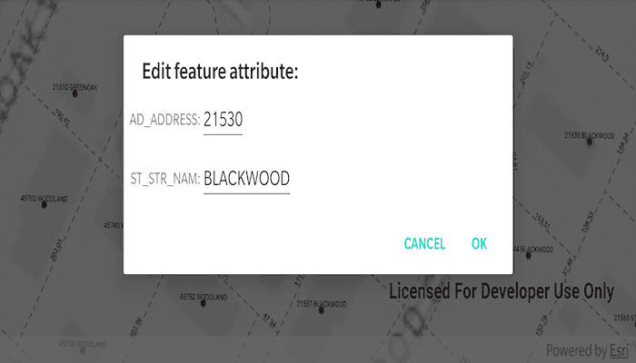
Pan and zoom the map to see that the text on the map is annotation, not labels. Tap one of the address points to update the house number (AD_ADDRESS) and street name (ST_STR_NAM). Tap one of the dashed parcel polylines and tap another location to change its geometry. NOTE: Selection is only enabled for points and straight (single segment) polylines.
The feature-linked annotation will update accordingly.
How it works
- Load the geodatabase. NOTE: Read/write geodatabases should normally come from a
GeodatabaseSyncTask. That functionality is covered in the sample Generate geodatabase. - Create
FeatureLayers fromGeodatabaseFeatureTables found in the geodatabase withgeodatabase.geodatabaseFeatureTables. - Create
AnnotationLayers fromGeodatabaseFeatureTables found in the geodatabase withgeodatabase.geodatabaseAnnotationTables. - Add the
FeatureLayers andAnnotationLayers to the map's operational layers. - Use a
DefaultMapViewOnTouchListenerto listen for taps on the map to either select address points or parcel polyline features. NOTE: Selection is only enabled for points and straight (signal segment) polylines. - For the address points, a dialog is opened to allow editing of the address number (AD_ADDRESS) and street name (ST_STR_NAM) attributes, which use the expression
$feature.AD_ADDRESS + " " + $feature.ST_STR_NAMfor annotation. - For the parcel lines, a second tap will change one of the polyline's vertices. Note that the dimension annotation updates according to the expression
Round(Length(Geometry($feature), 'feet'), 2).
Both expressions were defined by the data author in ArcGIS Pro using the Arcade expression language.
Relevant API
- AnnotationLayer
- Feature
- FeatureLayer
- Geodatabase
Offline Data
- Download the data from ArcGIS Online.
- Extract the contents of the downloaded zip file to disk.
- Open your command prompt and navigate to the folder where you extracted the contents of the data from step 1.
- Push the data into the scoped storage of the sample app:
adb push loudoun_anno.geodatabase /Android/data/com.esri.arcgisruntime.sample.editfeatureswithfeaturelinkedannotation/files/loudoun_anno.geodatabase
About the data
This sample uses data derived from the Loudoun GeoHub
Tags
annotation, attributes, feature-linked annotation, fields
Sample Code
/*
* Copyright 2020 Esri
*
* Licensed under the Apache License, Version 2.0 (the "License");
* you may not use this file except in compliance with the License.
* You may obtain a copy of the License at
*
* http://www.apache.org/licenses/LICENSE-2.0
*
* Unless required by applicable law or agreed to in writing, software
* distributed under the License is distributed on an "AS IS" BASIS,
* WITHOUT WARRANTIES OR CONDITIONS OF ANY KIND, either express or implied.
* See the License for the specific language governing permissions and
* limitations under the License.
*
*/
package com.esri.arcgisruntime.sample.editfeatureswithfeaturelinkedannotation
import android.os.Bundle
import android.util.Log
import android.view.LayoutInflater
import android.view.MotionEvent
import android.widget.Toast
import androidx.appcompat.app.AlertDialog
import androidx.appcompat.app.AppCompatActivity
import com.esri.arcgisruntime.ArcGISRuntimeEnvironment
import com.esri.arcgisruntime.data.Feature
import com.esri.arcgisruntime.data.Geodatabase
import com.esri.arcgisruntime.geometry.*
import com.esri.arcgisruntime.layers.AnnotationLayer
import com.esri.arcgisruntime.layers.FeatureLayer
import com.esri.arcgisruntime.mapping.ArcGISMap
import com.esri.arcgisruntime.mapping.BasemapStyle
import com.esri.arcgisruntime.mapping.Viewpoint
import com.esri.arcgisruntime.mapping.view.DefaultMapViewOnTouchListener
import com.esri.arcgisruntime.mapping.view.MapView
import com.esri.arcgisruntime.sample.editfeatureswithfeaturelinkedannotation.databinding.ActivityMainBinding
import com.esri.arcgisruntime.sample.editfeatureswithfeaturelinkedannotation.databinding.EditAttributeLayoutBinding
import kotlin.math.roundToInt
class MainActivity : AppCompatActivity() {
private val TAG = MainActivity::class.simpleName
private var selectedFeature: Feature? = null
private var selectedFeatureIsPolyline = false
private val activityMainBinding by lazy {
ActivityMainBinding.inflate(layoutInflater)
}
private val mapView: MapView by lazy {
activityMainBinding.mapView
}
override fun onCreate(savedInstanceState: Bundle?) {
super.onCreate(savedInstanceState)
setContentView(activityMainBinding.root)
// authentication with an API key or named user is required to access basemaps and other
// location services
ArcGISRuntimeEnvironment.setApiKey(BuildConfig.API_KEY)
// NOTE: to be a writable geodatabase, this geodatabase must be generated from a service with a
// GeodatabaseSyncTask. See the "generate geodatabase" sample to see how to generate a
// geodatabase
// create and load geodatabase
val geodatabase = Geodatabase(getExternalFilesDir(null)?.path + "/loudoun_anno.geodatabase")
geodatabase.loadAsync()
geodatabase.addDoneLoadingListener {
// create feature layers from tables in the geodatabase
val addressPointFeatureLayer =
FeatureLayer(geodatabase.getGeodatabaseFeatureTable("Loudoun_Address_Points_1"))
val parcelLinesFeatureLayer =
FeatureLayer(geodatabase.getGeodatabaseFeatureTable("ParcelLines_1"))
// create annotation layers from tables in the geodatabase
val addressPointsAnnotationLayer =
AnnotationLayer(geodatabase.getGeodatabaseAnnotationTable("Loudoun_Address_PointsAnno_1"))
val parcelLinesAnnotationLayer =
AnnotationLayer(geodatabase.getGeodatabaseAnnotationTable("ParcelLinesAnno_1"))
// create the map with a light gray canvas basemap
val map = ArcGISMap(BasemapStyle.ARCGIS_LIGHT_GRAY).apply {
// add the feature layers to the map
operationalLayers.add(parcelLinesFeatureLayer)
operationalLayers.add(addressPointFeatureLayer)
// add the annotation layers to the map
operationalLayers.add(parcelLinesAnnotationLayer)
operationalLayers.add(addressPointsAnnotationLayer)
}
mapView.apply {
// add the map to the map view
this.map = map
// set the initial viewpoint to Loudoun, Virginia
setViewpoint(Viewpoint(39.0204, -77.4159, 2000.0))
// set on tap behaviour
onTouchListener =
object : DefaultMapViewOnTouchListener(applicationContext, mapView) {
override fun onSingleTapUp(e: MotionEvent): Boolean {
val screenPoint =
android.graphics.Point(e.x.roundToInt(), e.y.roundToInt())
selectOrMove(screenPoint)
return true
}
}
}
}
}
/**
* Select the nearest feature, or move the point or polyline vertex to the given screen point.
*
* @param screenPoint at which to move or select feature
*/
private fun selectOrMove(screenPoint: android.graphics.Point) {
// if a feature hasn't been selected
if (selectedFeature == null) {
selectFeature(screenPoint)
} else {
// convert screen point to map point
val mapPoint = mapView.screenToLocation(screenPoint)
// move the feature
if (selectedFeatureIsPolyline) {
movePolylineVertex(mapPoint)
} else {
movePoint(mapPoint)
}
}
}
/**
* Select a feature near the given screen point using identify and, for a point feature, show a
* dialog to edit attributes. Future taps will call move functions.
*
* @param screenPoint at which to select a feature
*/
private fun selectFeature(screenPoint: android.graphics.Point) {
// clear any previously selected features
clearSelection()
// identify across all layers
val identifyLayerResultFuture = mapView.identifyLayersAsync(screenPoint, 10.0, false)
identifyLayerResultFuture.addDoneListener {
// get the list of result from the future
val identifyLayerResult = identifyLayerResultFuture.get()
// for each layer from which an element was identified
identifyLayerResult.forEach { result ->
// check if the layer is a feature layer, thereby excluding annotation layers
(result.layerContent as? FeatureLayer)?.let { featureLayer ->
// get a reference to the identified feature
selectedFeature = result.elements[0] as? Feature
// if the selected feature is a polyline with any part containing more than one segment
// (i.e. a curve)
(selectedFeature?.geometry as? Polyline)?.parts?.forEach {
if (it.pointCount > 2) {
// set selected feature to null
selectedFeature = null
// show message reminding user to select straight (single segment) polylines only
Toast.makeText(
this,
getString(R.string.curved_polylines_message),
Toast.LENGTH_SHORT
)
.show()
// return early, effectively disallowing selection of multi segmented polylines
return@forEach
}
}
selectedFeature?.let {
// select the feature
featureLayer.selectFeature(it)
when (it.geometry.geometryType) {
// when selected feature is a point, show editable attributes
GeometryType.POINT -> showEditableAttributes(it)
// when selected feature is a polyline,
GeometryType.POLYLINE -> selectedFeatureIsPolyline = true
else -> Log.e(TAG, "Feature of unexpected geometry type selected")
}
// return, since a feature has been selected
return@addDoneListener
}
}
}
}
}
/**
* Create an alert dialog with edit texts to allow editing of the given feature's 'AD_ADDRESS' and
* 'ST_STR_NAM' attributes.
*
* @param selectedFeature whose attributes will be edited
*/
private fun showEditableAttributes(selectedFeature: Feature) {
// inflate the edit attribute layout
val editAttributeLayoutBinding =
EditAttributeLayoutBinding.inflate(LayoutInflater.from(this))
// create an alert dialog
AlertDialog.Builder(this).apply {
setTitle("Edit feature attribute:")
setView(editAttributeLayoutBinding.root)
// populate edit texts with current attribute values
editAttributeLayoutBinding.addressNumberEditText.setText(selectedFeature.attributes["AD_ADDRESS"].toString())
editAttributeLayoutBinding.streetEditText.setText(selectedFeature.attributes["ST_STR_NAM"].toString())
setPositiveButton("OK") { _, _ ->
// set AD_ADDRESS value to the int from the edit text
val editAttributeString =
editAttributeLayoutBinding.addressNumberEditText.text.toString()
if (editAttributeString != "") {
selectedFeature.attributes["AD_ADDRESS"] = editAttributeString.toInt()
} else {
Toast.makeText(
applicationContext,
"AD_ADDRESS field must contain an integer!",
Toast.LENGTH_LONG
).show()
}
// set ST_STR_NAM value to the string from edit text
selectedFeature.attributes["ST_STR_NAM"] =
editAttributeLayoutBinding.streetEditText.text.toString()
// update the selected feature's feature table
selectedFeature.featureTable?.updateFeatureAsync(selectedFeature)
}
setNegativeButton("Cancel") { _, _ ->
clearSelection()
}
}.show()
}
/**
* Move the currently selected point feature to the given map point, by updating the selected
* feature's geometry and feature table.
*
* @param mapPoint to which the point geometry should be moved to
*/
private fun movePoint(mapPoint: Point) {
// set the selected features' geometry to a new map point
selectedFeature?.geometry = mapPoint
// update the selected feature's feature table
selectedFeature?.featureTable?.updateFeatureAsync(selectedFeature)
// clear selection of point
clearSelection()
}
/**
* Move the last of the vertex point of the currently selected polyline to the given map point, by updating the selected
* feature's geometry and feature table.
*
* @param mapPoint to which the last point of the polyline should be moved to
*/
private fun movePolylineVertex(mapPoint: Point) {
// get the selected feature's geometry as a polyline
val polyline = selectedFeature?.geometry as Polyline
// get the nearest vertex to the map point on the selected feature polyline
val nearestVertex = GeometryEngine.nearestVertex(
polyline,
GeometryEngine.project(mapPoint, polyline.spatialReference) as Point
)
val polylineBuilder = PolylineBuilder(polyline)
// get the part of the polyline nearest to the map point
polylineBuilder.parts[nearestVertex.partIndex.toInt()].apply {
// remove the nearest point to the map point
removePoint(nearestVertex.pointIndex.toInt())
// add the map point as the new point on the polyline
addPoint(GeometryEngine.project(mapPoint, spatialReference) as Point)
}
// set the selected feature's geometry to the new polyline
selectedFeature?.geometry = polylineBuilder.toGeometry()
// update the selected feature's feature table
selectedFeature?.featureTable?.updateFeatureAsync(selectedFeature)
// clear selection of polyline
clearSelection()
selectedFeatureIsPolyline = false
}
/**
* Clear selection from all feature layers.
*/
private fun clearSelection() {
mapView.map.operationalLayers.filterIsInstance<FeatureLayer>().forEach { featureLayer ->
featureLayer.clearSelection()
}
selectedFeature = null
}
override fun onPause() {
mapView.pause()
super.onPause()
}
override fun onResume() {
super.onResume()
mapView.resume()
}
override fun onDestroy() {
mapView.dispose()
super.onDestroy()
}
}