Identify features in all layers in a map.
Use case
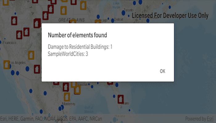
IdentifyLayers allows users to tap on a map, returning features at that location across multiple layers. Because some layer types have sublayers, the sample recursively counts results for sublayers within each layer.
How to use the sample
Tap to identify features. An alert will show all layers with features under the tapped location, as well as the number of features.
How it works
- The tapped position is passed to
MapView.identifyLayersAsync(...) - For each
IdentifyLayerResultin the results, features are counted.- Note: there is one identify result per layer with matching features; if the feature count is 0, that means a sublayer contains the matching features.
Relevant API
- IdentifyLayerResult
- IdentifyLayerResult.sublayerResults
- MapView.identifyLayersAsync(...)
Additional information
The GeoView supports two methods of identify: identifyLayerAsync(...), which identifies features within a specific layer and identifyLayersAsync(...), which identifies features for all layers in the current view.
Tags
identify, recursion, recursive, sublayers
Sample Code
MainActivity.kt
/*
* Copyright 2020 Esri
*
* Licensed under the Apache License, Version 2.0 (the "License")
* you may not use this file except in compliance with the License.
* You may obtain a copy of the License at
*
* http://www.apache.org/licenses/LICENSE-2.0
*
* Unless required by applicable law or agreed to in writing, software
* distributed under the License is distributed on an "AS IS" BASIS,
* WITHOUT WARRANTIES OR CONDITIONS OF ANY KIND, either express or implied.
* See the License for the specific language governing permissions and
* limitations under the License.
*
*/
package com.esri.arcgisruntime.sample.identifylayers
import android.os.Bundle
import android.util.Log
import android.view.MotionEvent
import android.widget.Toast
import androidx.appcompat.app.AlertDialog.Builder
import androidx.appcompat.app.AppCompatActivity
import com.esri.arcgisruntime.ArcGISRuntimeEnvironment
import com.esri.arcgisruntime.data.ServiceFeatureTable
import com.esri.arcgisruntime.geometry.Point
import com.esri.arcgisruntime.geometry.SpatialReference
import com.esri.arcgisruntime.layers.ArcGISMapImageLayer
import com.esri.arcgisruntime.layers.FeatureLayer
import com.esri.arcgisruntime.mapping.ArcGISMap
import com.esri.arcgisruntime.mapping.BasemapStyle
import com.esri.arcgisruntime.mapping.Viewpoint
import com.esri.arcgisruntime.mapping.view.DefaultMapViewOnTouchListener
import com.esri.arcgisruntime.mapping.view.IdentifyLayerResult
import com.esri.arcgisruntime.mapping.view.MapView
import com.esri.arcgisruntime.sample.identifylayers.databinding.ActivityMainBinding
import kotlin.math.roundToInt
class MainActivity : AppCompatActivity() {
private val activityMainBinding by lazy {
ActivityMainBinding.inflate(layoutInflater)
}
private val mapView: MapView by lazy {
activityMainBinding.mapView
}
override fun onCreate(savedInstanceState: Bundle?) {
super.onCreate(savedInstanceState)
setContentView(activityMainBinding.root)
// authentication with an API key or named user is required to access basemaps and other
// location services
ArcGISRuntimeEnvironment.setApiKey(BuildConfig.API_KEY)
// create a feature layer of damaged property data
val featureTable = ServiceFeatureTable(getString(R.string.damage_assessment))
val featureLayer = FeatureLayer(featureTable)
// create a layer with world cities data
val mapImageLayer = ArcGISMapImageLayer(getString(R.string.world_cities)).apply {
addDoneLoadingListener {
// hide continent and world layers
subLayerContents[1].isVisible = false
subLayerContents[2].isVisible = false
}
}
// create a topographic map
val map = ArcGISMap(BasemapStyle.ARCGIS_TOPOGRAPHIC).apply {
// add world cities layer
operationalLayers.add(mapImageLayer)
// add damaged property data
operationalLayers.add(featureLayer)
}
mapView.apply {
// assign the map to the map view
this.map = map
// set the map's initial viewpoint
setViewpoint(
Viewpoint(
Point(-10977012.785807, 4514257.550369, SpatialReference.create(3857)),
68015210.0
)
)
// add a listener to detect taps on the map view
onTouchListener = object : DefaultMapViewOnTouchListener(this@MainActivity, this) {
override fun onSingleTapConfirmed(e: MotionEvent?): Boolean {
e?.let {
val screenPoint = android.graphics.Point(
it.x.roundToInt(),
it.y.roundToInt()
)
identifyResult(screenPoint)
}
return true
}
}
}
}
/**
* Performs an identify on layers at the given screenpoint and calls handleIdentifyResults(...) to process them.
*
* @param screenPoint in Android graphic coordinates.
*/
private fun identifyResult(screenPoint: android.graphics.Point) {
val identifyLayerResultsFuture = mapView
.identifyLayersAsync(screenPoint, 12.0, false, 10)
identifyLayerResultsFuture.addDoneListener {
try {
val identifyLayerResults = identifyLayerResultsFuture.get()
handleIdentifyResults(identifyLayerResults)
} catch (e: Exception) {
logError("Error identifying results ${e.message}")
}
}
}
/**
* Processes identify results into a string which is passed to showAlertDialog(...).
*
* @param identifyLayerResults a list of identify results generated in identifyResult().
*/
private fun handleIdentifyResults(identifyLayerResults: List<IdentifyLayerResult>) {
val message = StringBuilder()
var totalCount = 0
for (identifyLayerResult in identifyLayerResults) {
val count = recursivelyCountIdentifyResultsForSublayers(identifyLayerResult)
val layerName = identifyLayerResult.layerContent.name
message.append(layerName).append(": ").append(count)
// add new line character if not the final element in array
if (identifyLayerResult != identifyLayerResults[identifyLayerResults.size - 1]) {
message.append("\n")
}
totalCount += count
}
// if any elements were found show the results, else notify user that no elements were found
if (totalCount > 0) {
showAlertDialog(message)
} else {
logError("No element found")
}
}
/**
* Gets a count of the GeoElements in the passed result layer.
* This method recursively calls itself to descend into sublayers and count their results.
* @param result from a single layer.
* @return the total count of GeoElements.
*/
private fun recursivelyCountIdentifyResultsForSublayers(result: IdentifyLayerResult): Int {
var subLayerGeoElementCount = 0
for (sublayerResult in result.sublayerResults) {
// recursively call this function to accumulate elements from all sublayers
subLayerGeoElementCount += recursivelyCountIdentifyResultsForSublayers(sublayerResult)
}
return subLayerGeoElementCount + result.elements.size
}
/**
* Shows message in an AlertDialog.
*
* @param message contains identify results processed into a string.
*/
private fun showAlertDialog(message: StringBuilder) {
val alertDialogBuilder = Builder(this)
// set title
alertDialogBuilder.setTitle("Number of elements found")
// set dialog message
alertDialogBuilder
.setMessage(message)
.setCancelable(false)
.setPositiveButton(getString(R.string.ok)) { dialog, which -> }
// create alert dialog
val alertDialog = alertDialogBuilder.create()
// show the alert dialog
alertDialog.show()
}
override fun onResume() {
super.onResume()
mapView.resume()
}
override fun onPause() {
mapView.pause()
super.onPause()
}
override fun onDestroy() {
mapView.dispose()
super.onDestroy()
}
/**
* Log an error to logcat and to the screen via Toast.
* @param message the text to log.
*/
private fun logError(message: String?) {
message?.let {
Log.e(
TAG,
message
)
Toast.makeText(this, message, Toast.LENGTH_LONG).show()
}
}
private companion object {
private val TAG: String = MainActivity::class.java.simpleName
}
}