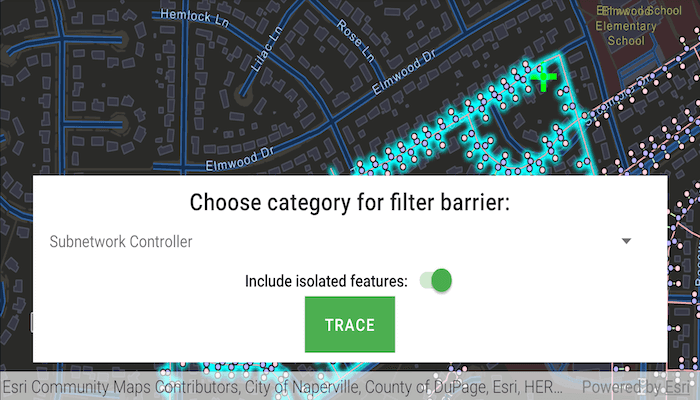
Run a filtered trace to locate operable features that will isolate an area from the flow of network resources.
Use case
Determine the set of operable features required to stop a network's resource, effectively isolating an area of the network. For example, you can choose to return only accessible and operable valves: ones that are not paved over or rusted shut.
How to use the sample
Create and set the configuration's filter barriers by selecting a category. Toggle 'Include isolated features' as required. Tap 'Trace' to run a subnetwork-based isolation trace.
How it works
- Create a
MapView. - Create and load a
ServiceGeodatabasewith a feature service URL and get tables with their layer IDs. - Create an
ArcGISMapobject that containsFeatureLayer(s) created from the service geodatabase's tables. - Create and load an
UtilityNetworkwith the same feature service URL and map. - Create a default starting location from a given asset type and global ID.
- Add a
GraphicsOverlaywith anGraphicthat represents this starting location. - Populate the choice list for the filter barriers from the
categoriesproperty ofUtilityNetworkDefinition. - Get a default
UtilityTraceConfigurationfrom a given tier in a domain network. Set itsfilterproperty with anUtilityTraceFilterobject. - When "Trace" is tapped,
- Create a new
UtilityCategoryComparisonwith the selected category andUtilityCategoryComparisonOperator.EXISTS. - Assign this condition to
traceConfiguration.filter.barriersfrom the default configuration from step 7. Update this configuration'sisIncludeIsolatedFeaturesproperty. - Create a
UtilityTraceParameterswithUtilityTraceType.ISOLATIONand the default starting location from step 4. - Set its
UtilityTraceConfigurationwith this configuration and then, run aUtilityNetwork.traceAsync(traceParameters).
- Create a new
- For every
FeatureLayerin the map, createQueryParametersand add any of theUtilityElementTraceResult.elementswhoseNetworkSource.namematches the feature layer'sFeatureTable.tableName. Use the query parameters to select the features withfeatureLayer.selectFeaturesAsync(...)
Relevant API
- ServiceGeodatabase
- UtilityCategory
- UtilityCategoryComparison
- UtilityCategoryComparisonOperator
- UtilityElement
- UtilityElementTraceResult
- UtilityNetwork
- UtilityNetworkDefinition
- UtilityTier
- UtilityTraceFilter
- UtilityTraceParameters
- UtilityTraceResult
- UtilityTraceType
About the data
The Naperville gas network feature service, hosted on ArcGIS Online, contains a utility network used to run the isolation trace shown in this sample.
Tags
category comparison, condition barriers, isolated features, network analysis, subnetwork trace, trace configuration, trace filter, utility network
Sample Code
/*
* Copyright 2020 Esri
*
* Licensed under the Apache License, Version 2.0 (the "License");
* you may not use this file except in compliance with the License.
* You may obtain a copy of the License at
*
* http://www.apache.org/licenses/LICENSE-2.0
*
* Unless required by applicable law or agreed to in writing, software
* distributed under the License is distributed on an "AS IS" BASIS,
* WITHOUT WARRANTIES OR CONDITIONS OF ANY KIND, either express or implied.
* See the License for the specific language governing permissions and
* limitations under the License.
*
*/
package com.esri.arcgisruntime.sample.performvalveisolationtrace
import android.graphics.Color
import android.os.Bundle
import android.util.Log
import android.view.LayoutInflater
import android.view.MotionEvent
import android.view.View
import android.view.ViewGroup
import android.widget.*
import android.widget.ArrayAdapter
import android.widget.Toast
import androidx.appcompat.app.AlertDialog
import androidx.appcompat.app.AppCompatActivity
import androidx.appcompat.widget.SwitchCompat
import androidx.coordinatorlayout.widget.CoordinatorLayout
import com.esri.arcgisruntime.ArcGISRuntimeEnvironment
import com.esri.arcgisruntime.data.ArcGISFeature
import com.esri.arcgisruntime.data.QueryParameters
import com.esri.arcgisruntime.data.ServiceGeodatabase
import com.esri.arcgisruntime.geometry.GeometryEngine
import com.esri.arcgisruntime.geometry.Point
import com.esri.arcgisruntime.geometry.Polyline
import com.esri.arcgisruntime.layers.FeatureLayer
import com.esri.arcgisruntime.loadable.LoadStatus
import com.esri.arcgisruntime.mapping.ArcGISMap
import com.esri.arcgisruntime.mapping.BasemapStyle
import com.esri.arcgisruntime.mapping.Viewpoint
import com.esri.arcgisruntime.mapping.view.DefaultMapViewOnTouchListener
import com.esri.arcgisruntime.mapping.view.Graphic
import com.esri.arcgisruntime.mapping.view.GraphicsOverlay
import com.esri.arcgisruntime.security.UserCredential
import com.esri.arcgisruntime.mapping.view.MapView
import com.esri.arcgisruntime.sample.performvalveisolationtrace.databinding.ActivityMainBinding
import com.esri.arcgisruntime.sample.performvalveisolationtrace.databinding.SpinnerTextItemBinding
import com.esri.arcgisruntime.symbology.SimpleMarkerSymbol
import com.esri.arcgisruntime.symbology.SimpleRenderer
import com.esri.arcgisruntime.utilitynetworks.UtilityCategory
import com.esri.arcgisruntime.utilitynetworks.UtilityCategoryComparison
import com.esri.arcgisruntime.utilitynetworks.UtilityCategoryComparisonOperator
import com.esri.arcgisruntime.utilitynetworks.UtilityElement
import com.esri.arcgisruntime.utilitynetworks.UtilityElementTraceResult
import com.esri.arcgisruntime.utilitynetworks.UtilityNetwork
import com.esri.arcgisruntime.utilitynetworks.UtilityNetworkDefinition
import com.esri.arcgisruntime.utilitynetworks.UtilityNetworkSource
import com.esri.arcgisruntime.utilitynetworks.UtilityTerminal
import com.esri.arcgisruntime.utilitynetworks.UtilityTraceConfiguration
import com.esri.arcgisruntime.utilitynetworks.UtilityTraceFilter
import com.esri.arcgisruntime.utilitynetworks.UtilityTraceParameters
import com.esri.arcgisruntime.utilitynetworks.UtilityTraceType
import com.google.android.material.floatingactionbutton.FloatingActionButton
import java.util.UUID
import java.util.*
import kotlin.math.roundToInt
class MainActivity : AppCompatActivity() {
private val TAG = MainActivity::class.java.simpleName
private val activityMainBinding by lazy {
ActivityMainBinding.inflate(layoutInflater)
}
private val mapView: MapView by lazy {
activityMainBinding.mapView
}
private val fab: FloatingActionButton by lazy {
activityMainBinding.fab
}
private val traceControlsTextView: TextView by lazy {
activityMainBinding.traceControlsTextView
}
private val progressBar: ProgressBar by lazy {
activityMainBinding.progressBar
}
private val traceTypeSpinner: Spinner by lazy {
activityMainBinding.traceTypeSpinner
}
private val traceButton: Button by lazy {
activityMainBinding.traceButton
}
private val resetButton: Button by lazy {
activityMainBinding.resetButton
}
private val includeIsolatedSwitch: SwitchCompat by lazy {
activityMainBinding.includeIsolatedSwitch
}
// objects that implement Loadable must be class fields to prevent being garbage collected before loading
private val featureServiceUrl =
"https://sampleserver7.arcgisonline.com/server/rest/services/UtilityNetwork/NapervilleGas/FeatureServer"
private val utilityNetwork by lazy {
UtilityNetwork(featureServiceUrl)
}
// create a graphics overlay for the starting location and add it to the map view
private val startingLocationGraphicsOverlay by lazy {
GraphicsOverlay()
}
private val filterBarriersGraphicsOverlay by lazy {
GraphicsOverlay()
}
private var utilityTraceParameters: UtilityTraceParameters? = null
private val serviceGeodatabase by lazy {
ServiceGeodatabase(featureServiceUrl)
}
// create and apply renderers for the starting point graphics overlay
private val startingPointSymbol: SimpleMarkerSymbol by lazy {
SimpleMarkerSymbol(
SimpleMarkerSymbol.Style.CROSS,
Color.GREEN,
25f
)
}
override fun onCreate(savedInstanceState: Bundle?) {
super.onCreate(savedInstanceState)
setContentView(activityMainBinding.root)
// authentication with an API key or named user is required to access basemaps and other
// location services
ArcGISRuntimeEnvironment.setApiKey(BuildConfig.API_KEY)
loadServiceGeodatabase()
// create a map with the utility network distribution line and device layers
val map = ArcGISMap(BasemapStyle.ARCGIS_STREETS_NIGHT).apply {
// create and load the utility network
addDoneLoadingListener {
utilityNetworks.add(utilityNetwork)
}
}
mapView.apply {
this.map = map
// set the starting location graphic overlay's renderer and add it to the map view
startingLocationGraphicsOverlay.renderer = SimpleRenderer(startingPointSymbol)
graphicsOverlays.add(startingLocationGraphicsOverlay)
// set the viewpoint to a specific location in Naperville, Illinois
setViewpointAsync(Viewpoint(Point(-9812712.321100, 5124260.390000, 0.000100), 5000.0))
// make sure the fab doesn't obscure the attribution bar
addAttributionViewLayoutChangeListener { _, _, _, _, bottom, _, _, _, oldBottom ->
val layoutParams = fab.layoutParams as CoordinatorLayout.LayoutParams
layoutParams.bottomMargin += bottom - oldBottom
}
// close the options sheet when the map is tapped
onTouchListener = object : DefaultMapViewOnTouchListener(this@MainActivity, mapView) {
override fun onTouch(view: View?, event: MotionEvent?): Boolean {
if (fab.isExpanded) {
fab.isExpanded = false
}
return super.onTouch(view, event)
}
override fun onSingleTapConfirmed(e: MotionEvent): Boolean {
// only pass taps to identify nearest utility element once the utility network has loaded
if (utilityNetwork.loadStatus == LoadStatus.LOADED) {
identifyNearestUtilityElement(
android.graphics.Point(e.x.roundToInt(), e.y.roundToInt())
)
traceTypeSpinner.isEnabled = false
return true
}
return false
}
}
}
// show the options sheet when the floating action button is clicked
fab.setOnClickListener {
fab.isExpanded = !fab.isExpanded
}
}
/*** Load the service geodatabase and initialize the layers.
*/
private fun loadServiceGeodatabase() {
// set user credentials to authenticate with the service
// NOTE: a licensed user is required to perform utility network operations
serviceGeodatabase.credential = UserCredential("viewer01", "I68VGU^nMurF")
serviceGeodatabase.addDoneLoadingListener {
if (serviceGeodatabase.loadStatus == LoadStatus.LOADED) {
// The gas device layer ./0 and gas line layer ./3 are created from the service geodatabase.
val gasDeviceLayerTable = serviceGeodatabase.getTable(0)
val gasLineLayerTable = serviceGeodatabase.getTable(3)
// load the utility network data from the feature service and create feature layers
val deviceLayer = FeatureLayer(gasDeviceLayerTable)
val distributionLineLayer = FeatureLayer(gasLineLayerTable)
// add the utility network feature layers to the map for display
mapView.map.operationalLayers.add(deviceLayer)
mapView.map.operationalLayers.add(distributionLineLayer)
loadUtilityNetwork()
} else {
val error =
"Error loading service geodatabase: " + serviceGeodatabase.loadError.cause?.message
Toast.makeText(this, error, Toast.LENGTH_LONG).show()
Log.e(TAG, error)
}
}
serviceGeodatabase.loadAsync()
}
/**
* Create and load a utility network from the string resource url and initialize a starting point
* from it.
*/
private fun loadUtilityNetwork(): UtilityNetwork {
utilityNetwork.loadAsync()
utilityNetwork.addDoneLoadingListener {
if (utilityNetwork.loadStatus == LoadStatus.LOADED) {
// get a trace configuration from a tier
val networkDefinition = utilityNetwork.definition
val domainNetwork = networkDefinition.getDomainNetwork("Pipeline")
val tier = domainNetwork.getTier("Pipe Distribution System")
val traceConfiguration = tier.traceConfiguration
// create a trace filter
traceConfiguration.filter = UtilityTraceFilter()
// get a default starting location
val networkSource = networkDefinition.getNetworkSource("Gas Device")
val assetGroup = networkSource.getAssetGroup("Meter")
val assetType = assetGroup.getAssetType("Customer")
val startingLocation = utilityNetwork.createElement(
assetType,
UUID.fromString("98A06E95-70BE-43E7-91B7-E34C9D3CB9FF")
)
// create new base trace parameters
utilityTraceParameters = UtilityTraceParameters(
UtilityTraceType.ISOLATION,
Collections.singletonList(startingLocation)
)
// get a list of features for the starting location element
val elementFeaturesFuture =
utilityNetwork.fetchFeaturesForElementsAsync(listOf(startingLocation))
elementFeaturesFuture.addDoneListener {
try {
val startingLocationFeatures = elementFeaturesFuture.get()
if (startingLocationFeatures.isNotEmpty()) {
// get the geometry of the first feature for the starting location as a point
(startingLocationFeatures[0].geometry as? Point)?.let { startingLocationGeometryPoint ->
// create a graphic for the starting location and add it to the graphics overlay
val startingLocationGraphic =
Graphic(startingLocationGeometryPoint, startingPointSymbol)
startingLocationGraphicsOverlay.graphics.add(startingLocationGraphic)
// create a graphics overlay for filter barriers and add it to the map view
mapView.graphicsOverlays.add(filterBarriersGraphicsOverlay)
// create and apply a renderer for the filter barriers graphics overlay
val barrierPointSymbol = SimpleMarkerSymbol(
SimpleMarkerSymbol.Style.CROSS, Color.RED, 25f
)
filterBarriersGraphicsOverlay.renderer = SimpleRenderer(
barrierPointSymbol
)
populateCategorySpinner(networkDefinition)
traceButton.setOnClickListener {
fab.isExpanded = false
performTrace(
utilityNetwork,
traceConfiguration
)
}
resetButton.setOnClickListener {
reset(
)
}
}
} else {
val message = "Starting location features not found."
Log.i(TAG, message)
Toast.makeText(
this,
message,
Toast.LENGTH_LONG
).show()
}
} catch (e: Exception) {
val error = "Error loading starting location feature: ${e.message}"
Log.e(TAG, error)
Toast.makeText(this, error, Toast.LENGTH_LONG).show()
}
}
} else {
val error = "Error loading utility network: ${utilityNetwork.loadError}"
Log.e(TAG, error)
Toast.makeText(this, error, Toast.LENGTH_LONG).show()
}
}
return utilityNetwork
}
private fun identifyNearestUtilityElement(screenPoint: android.graphics.Point) {
traceControlsTextView.text = getString(R.string.add_another_filter_barrier)
// ensure the utility network is loaded before processing clicks on the map view
if (utilityNetwork.loadStatus == LoadStatus.LOADED) {
// show the progress indicator
progressBar.visibility = View.VISIBLE
// identify the feature to be used
val identifyLayerResultsFuture = mapView.identifyLayersAsync(screenPoint, 10.0, false)
identifyLayerResultsFuture.addDoneListener {
try {
// get the result of the query
val identifyLayerResults = identifyLayerResultsFuture.get()
// return if no features are identified
if (identifyLayerResults.isNotEmpty()) {
// retrieve the identify result elements as ArcGISFeatures
val elements = identifyLayerResults.map { it.elements[0] as ArcGISFeature }
// create utility elements from the list of ArcGISFeature elements
val utilityElements = elements.map { utilityNetwork.createElement(it) }
// get a reference to the closest junction if there is one
val junction =
utilityElements.firstOrNull { it.networkSource.sourceType == UtilityNetworkSource.Type.JUNCTION }
// get a reference to the closest edge if there is one
val edge =
utilityElements.firstOrNull { it.networkSource.sourceType == UtilityNetworkSource.Type.EDGE }
// preferentially select junctions, otherwise an edge
val utilityElement = junction ?: edge
// retrieve the first result and get its contents
if (junction != null) {
// check if the feature has a terminal configuration and multiple terminals
if (junction.assetType.terminalConfiguration != null) {
val utilityTerminalConfiguration =
junction.assetType.terminalConfiguration
val terminals =
utilityTerminalConfiguration.terminals
if (terminals.size > 1) {
// prompt the user to select a terminal for this feature
promptForTerminalSelection(junction, terminals)
}
}
} else if (edge != null) {
// get the geometry of the identified feature as a polyline, and remove the z component
val polyline =
GeometryEngine.removeZ(elements[0].geometry) as Polyline
// get the clicked map point
val mapPoint = mapView.screenToLocation(screenPoint)
// compute how far the clicked location is along the edge feature
val fractionAlongEdge =
GeometryEngine.fractionAlong(polyline, mapPoint, -1.0)
if (fractionAlongEdge.isNaN()) {
Toast.makeText(
this,
"Cannot add starting location or barrier here.",
Toast.LENGTH_LONG
).show()
return@addDoneListener
}
// set the fraction along edge
edge.fractionAlongEdge = fractionAlongEdge
// update the status label text
Toast.makeText(
this,
"Fraction along edge: " + edge.fractionAlongEdge.roundToInt(),
Toast.LENGTH_LONG
).show()
}
// add the element to the list of filter barriers
utilityTraceParameters?.filterBarriers?.add(utilityElement)
// get the clicked map point
val mapPoint = mapView.screenToLocation(screenPoint)
// find the closest coordinate on the selected element to the clicked point
val proximityResult =
GeometryEngine.nearestCoordinate(elements[0].geometry, mapPoint)
// create a graphic for the new utility element
val utilityElementGraphic = Graphic().apply {
// set the graphic's geometry to the coordinate on the element and add it to the graphics overlay
geometry = proximityResult.coordinate
}
// add utility element graphic to the filter barriers graphics overlay
filterBarriersGraphicsOverlay.graphics.add(utilityElementGraphic)
}
} catch (e: Exception) {
val error = "Error identifying tapped feature: " + e.message
Log.e(TAG, error)
Toast.makeText(this, error, Toast.LENGTH_LONG).show()
} finally {
progressBar.visibility = View.GONE
}
}
}
}
/**
* Prompts the user to select a terminal from a provided list.
*
* @param terminals a list of terminals for the user to choose from
* @return the user's selected terminal
*/
private fun promptForTerminalSelection(
utilityElement: UtilityElement,
terminals: List<UtilityTerminal>
) {
// get a list of terminal names from the terminals
val terminalNames = terminals.map { it.name }
AlertDialog.Builder(this).apply {
setTitle("Select utility terminal:")
setItems(terminalNames.toTypedArray()) { _, which ->
// apply the selected terminal
val terminal = terminals[which]
utilityElement.terminal = terminal
// show the terminals name in the status label
val terminalName = if (terminal.name != null) terminal.name else "default"
Toast.makeText(
this@MainActivity,
"Feature added at terminal: $terminalName",
Toast.LENGTH_LONG
).show()
}.show()
}
}
/**
* Performs a valve isolation trace according to the defined trace configuration and starting* location, and selects the resulting features on the map.
*
* @param utilityNetwork the utility network to perform the trace on
* @param traceConfiguration the trace configuration to apply to the trace
*/
private fun performTrace(
utilityNetwork: UtilityNetwork,
traceConfiguration: UtilityTraceConfiguration
) {
progressBar.visibility = View.VISIBLE
// create a category comparison for the trace
// NOTE: UtilityNetworkAttributeComparison or UtilityCategoryComparisonOperator.DOES_NOT_EXIST
// can also be used. These conditions can be joined with either UtilityTraceOrCondition or UtilityTraceAndCondition.
val utilityCategoryComparison = UtilityCategoryComparison(
traceTypeSpinner.selectedItem as UtilityCategory,
UtilityCategoryComparisonOperator.EXISTS
)
// set the category comparison to the barriers of the configuration's trace filter
traceConfiguration.apply {
filter = UtilityTraceFilter()
filter.barriers = utilityCategoryComparison
// set the configuration to include or leave out isolated features
isIncludeIsolatedFeatures = includeIsolatedSwitch.isChecked
}
// build parameters for the isolation trace
utilityTraceParameters!!.traceConfiguration = traceConfiguration
// run the trace and get the result
val utilityTraceResultsFuture = utilityNetwork.traceAsync(utilityTraceParameters)
utilityTraceResultsFuture.addDoneListener {
try {
// get the first element of the trace result if it is not null
(utilityTraceResultsFuture.get()[0] as? UtilityElementTraceResult)?.let { utilityElementTraceResult ->
if (utilityElementTraceResult.elements.isNotEmpty()) {
// iterate over the map's feature layers
mapView.map.operationalLayers.filterIsInstance<FeatureLayer>()
.forEach { featureLayer ->
// clear any selections from a previous trace
featureLayer.clearSelection()
val queryParameters = QueryParameters()
// for each utility element in the trace, check if its network source is the same as
// the feature table, and if it is, add it to the query parameters to be selected
utilityElementTraceResult.elements.filter { it.networkSource.name == featureLayer.featureTable.tableName }
.forEach { utilityElement ->
queryParameters.objectIds.add(utilityElement.objectId)
}
// select features that match the query
featureLayer.selectFeaturesAsync(
queryParameters,
FeatureLayer.SelectionMode.NEW
)
}
} else {
// iterate over the map's feature layers
mapView.map.operationalLayers.filterIsInstance<FeatureLayer>()
.forEach { featureLayer ->
// clear any selections from a previous trace
featureLayer.clearSelection()
}
// trace result is empty
val message = "Utility Element Trace Result had no elements!"
Log.i(TAG, message)
Toast.makeText(this, message, Toast.LENGTH_LONG).show()
}
}
// hide the progress bar when the trace is completed or failed
progressBar.visibility = View.GONE
} catch (e: Exception) {
val error = "Error loading utility trace results: ${e.message}"
Log.e(TAG, error)
Toast.makeText(this, error, Toast.LENGTH_LONG).show()
}
}
}
private fun reset() {
traceControlsTextView.text = getString(R.string.choose_category_for_filter_barrier)
traceTypeSpinner.isEnabled = true
mapView.map.operationalLayers.forEach { layer ->
(layer as? FeatureLayer)?.clearSelection()
}
utilityTraceParameters?.filterBarriers?.clear()
filterBarriersGraphicsOverlay.graphics.clear()
}
/**
* Initialize the category selection spinner using a utility network definition.
*
* @param networkDefinition the utility network definition to populate the spinner
*/
private fun populateCategorySpinner(
networkDefinition: UtilityNetworkDefinition
) {
// populate the spinner with utility categories as the data and their names as the text
traceTypeSpinner.adapter =
object : ArrayAdapter<UtilityCategory>(
this,
R.layout.spinner_text_item,
networkDefinition.categories
) {
override fun getView(position: Int, convertView: View?, parent: ViewGroup): View {
val binding = SpinnerTextItemBinding.inflate(
LayoutInflater.from(parent.context),
parent,
false
)
binding.textView.text = (getItem(position) as UtilityCategory).name
return binding.root
}
override fun getDropDownView(
position: Int,
convertView: View?,
parent: ViewGroup
): View = getView(position, convertView, parent)
}
}
override fun onResume() {
super.onResume()
mapView.resume()
}
override fun onPause() {
mapView.pause()
super.onPause()
}
override fun onDestroy() {
mapView.dispose()
super.onDestroy()
}
}