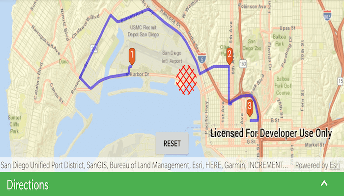
Find a route that reaches all stops without crossing any barriers.
Use case
You can define barriers to avoid unsafe areas, for example flooded roads, when planning the most efficient route to evacuate a hurricane zone. When solving a route, barriers allow you to define portions of the road network that cannot be traversed. You could also use this functionality to plan routes when you know an area will be inaccessible due to a community activity like an organized race or a market night.
In some situations, it is further beneficial to find the most efficient route that reaches all stops, reordering them to reduce travel time. For example, a delivery service may target a number of drop-off addresses, specifically looking to avoid congested areas or closed roads, arranging the stops in the most time-effective order.
How to use the sample
Tap 'Route controls' to pull up a bottom sheet that contains UI to setup your route task parameters. Click 'Add stop' to add stops to the route. Click 'Add barrier' to add areas that can't be crossed by the route. Click 'Solve route' to find the route and display it. Check 'Allow stops to be re-ordered' to find the best sequence. Check 'Preserve first stop' if there is a known start point, and 'Preserve last stop' if there is a known final destination. Press the reset button to start again.
After tapping 'solve route' the bottom sheet will show a list of directions along the route. Tap any of the directions to focus the map view on the relevant part of the route.
How it works
- Create the route task by calling
RouteTaskwith a URL to a Network Analysis route service. - Get the default route parameters for the service by calling
createDefaultParametersAsync()on the route task. - When the user adds a stop, add it to the route parameters.
- Normalize the geometry; otherwise the route job would fail if the user included any stops over the 180th degree meridian.
- Get the name of the stop by counting the existing stops -
stopList.size. - Create a composite symbol for the stop. This sample uses a pushpin marker and a text symbol.
- Create the graphic from the geometry and the symbol.
- Add the graphic to the stops graphics overlay.
- When the user adds a barrier, create a polygon barrier and add it to the route parameters.
- Normalize the geometry (see 3i above).
- Buffer the geometry to create a larger barrier from the tapped point by calling
GeometryEngine.buffer(mapPoint, 500.0). - Create the graphic from the geometry and the symbol.
- Add the graphic to the barriers overlay.
- When ready to find the route, configure the route parameters.
- Set the
isReturnStopsandisReturnDirectionstotrue. - Create a
Stopfor each graphic in the stops graphics overlay. Add that stop to a list, then callsetStops(stopList). - Create a
PolygonBarrierfor each graphic in the barriers graphics overlay. Add that barrier to a list, then callsetPolygonBarriers(barrierList). - If the user will accept routes with the stops in any order, set
findBestSequencetotrueto find the most optimal route. - If the user has a definite start point, set
preserveFirstStoptotrue. - If the user has a definite final destination, set
preserveLastStoptotrue.
- Set the
- Calculate and display the route.
- Call
routeTask.solveRouteAsync(routeParameters)to get aRouteResult. - Get the first returned route by calling
routeResult.routes[0]. - Get the geometry from the route, as a polyline, by accessing the
firstResult.routeGeometryproperty. - Create a graphic from the polyline and a simple line symbol.
- Display the steps on the route, available from
firstResult.directionManeuvers.
- Call
Relevant API
- DirectionManeuver
- PolygonBarrier
- Route
- Route.DirectionManeuver
- Route.RouteGeometry
- RouteParameters.ClearPolygonBarriers
- RouteParameters.FindBestSequence
- RouteParameters.PreserveFirstStop
- RouteParameters.PreserveLastStop
- RouteParameters.ReturnDirections
- RouteParameters.ReturnStops
- RouteParameters.SetPolygonBarriers
- RouteResult
- RouteResult.Routes
- RouteTask
- Stop
- Stop.Name
About the data
This sample uses an Esri-hosted sample street network for San Diego.
Tags
barriers, best sequence, directions, maneuver, network analysis, routing, sequence, stop order, stops
Sample Code
/*
* Copyright 2020 Esri
*
* Licensed under the Apache License, Version 2.0 (the "License");
* you may not use this file except in compliance with the License.
* You may obtain a copy of the License at
*
* http://www.apache.org/licenses/LICENSE-2.0
*
* Unless required by applicable law or agreed to in writing, software
* distributed under the License is distributed on an "AS IS" BASIS,
* WITHOUT WARRANTIES OR CONDITIONS OF ANY KIND, either express or implied.
* See the License for the specific language governing permissions and
* limitations under the License.
*
*/
package com.esri.arcgisruntime.sample.routearoundbarriers
import android.graphics.Color
import android.graphics.drawable.BitmapDrawable
import android.os.Bundle
import android.util.Log
import android.view.MotionEvent
import android.view.View
import android.view.View.GONE
import android.view.View.VISIBLE
import android.widget.*
import androidx.appcompat.app.AppCompatActivity
import androidx.constraintlayout.widget.ConstraintLayout
import androidx.coordinatorlayout.widget.CoordinatorLayout
import androidx.core.content.ContextCompat
import com.esri.arcgisruntime.ArcGISRuntimeEnvironment
import com.esri.arcgisruntime.geometry.GeometryEngine
import com.esri.arcgisruntime.geometry.Point
import com.esri.arcgisruntime.loadable.LoadStatus
import com.esri.arcgisruntime.mapping.ArcGISMap
import com.esri.arcgisruntime.mapping.BasemapStyle
import com.esri.arcgisruntime.mapping.Viewpoint
import com.esri.arcgisruntime.mapping.view.DefaultMapViewOnTouchListener
import com.esri.arcgisruntime.mapping.view.Graphic
import com.esri.arcgisruntime.mapping.view.GraphicsOverlay
import com.esri.arcgisruntime.mapping.view.MapView
import com.esri.arcgisruntime.sample.routearoundbarriers.databinding.ActivityMainBinding
import com.esri.arcgisruntime.symbology.CompositeSymbol
import com.esri.arcgisruntime.symbology.PictureMarkerSymbol
import com.esri.arcgisruntime.symbology.SimpleFillSymbol
import com.esri.arcgisruntime.symbology.SimpleLineSymbol
import com.esri.arcgisruntime.symbology.SimpleRenderer
import com.esri.arcgisruntime.symbology.TextSymbol
import com.esri.arcgisruntime.tasks.networkanalysis.DirectionManeuver
import com.esri.arcgisruntime.tasks.networkanalysis.PolygonBarrier
import com.esri.arcgisruntime.tasks.networkanalysis.Route
import com.esri.arcgisruntime.tasks.networkanalysis.RouteParameters
import com.esri.arcgisruntime.tasks.networkanalysis.RouteResult
import com.esri.arcgisruntime.tasks.networkanalysis.RouteTask
import com.esri.arcgisruntime.tasks.networkanalysis.Stop
import com.google.android.material.bottomsheet.BottomSheetBehavior
import kotlin.math.roundToInt
class MainActivity : AppCompatActivity() {
private val TAG: String = MainActivity::class.java.simpleName
private var bottomSheetBehavior: BottomSheetBehavior<View>? = null
private var routeTask: RouteTask? = null
private var routeParameters: RouteParameters? = null
private var pinSymbol: PictureMarkerSymbol? = null
private val routeGraphicsOverlay by lazy { GraphicsOverlay() }
private val stopsGraphicsOverlay by lazy { GraphicsOverlay() }
private val barriersGraphicsOverlay by lazy { GraphicsOverlay() }
private val stopList by lazy { mutableListOf<Stop>() }
private val barrierList by lazy { mutableListOf<PolygonBarrier>() }
private val directionsList by lazy { mutableListOf<DirectionManeuver>() }
private val routeLineSymbol by lazy {
SimpleLineSymbol(
SimpleLineSymbol.Style.SOLID,
Color.BLUE,
5.0f
)
}
private val barrierSymbol by lazy {
SimpleFillSymbol(
SimpleFillSymbol.Style.DIAGONAL_CROSS,
Color.RED,
null
)
}
private val activityMainBinding by lazy {
ActivityMainBinding.inflate(layoutInflater)
}
private val mapView: MapView by lazy {
activityMainBinding.mapView
}
private val mapViewContainer: ConstraintLayout by lazy {
activityMainBinding.mapViewContainer
}
private val resetButton: Button by lazy {
activityMainBinding.resetButton
}
private val bottomSheet: LinearLayout by lazy {
activityMainBinding.bottomSheet.bottomSheetLayout
}
private val header: ConstraintLayout by lazy {
activityMainBinding.bottomSheet.header
}
private val imageView: ImageView by lazy {
activityMainBinding.bottomSheet.imageView
}
private val addStopButton: ToggleButton by lazy {
activityMainBinding.bottomSheet.addStopButton
}
private val addBarrierButton: ToggleButton by lazy {
activityMainBinding.bottomSheet.addBarrierButton
}
private val reorderCheckBox: CheckBox by lazy {
activityMainBinding.bottomSheet.reorderCheckBox
}
private val preserveFirstStopCheckBox: CheckBox by lazy {
activityMainBinding.bottomSheet.preserveFirstStopCheckBox
}
private val preserveLastStopCheckBox: CheckBox by lazy {
activityMainBinding.bottomSheet.preserveLastStopCheckBox
}
private val directionsTextView: TextView by lazy {
activityMainBinding.bottomSheet.directionsTextView
}
private val directionsListView: ListView by lazy {
activityMainBinding.bottomSheet.directionsListView
}
override fun onCreate(savedInstanceState: Bundle?) {
super.onCreate(savedInstanceState)
setContentView(activityMainBinding.root)
// authentication with an API key or named user is required to access basemaps and other
// location services
ArcGISRuntimeEnvironment.setApiKey(BuildConfig.API_KEY)
// create simple renderer for routes, and set it to use the line symbol
routeGraphicsOverlay.renderer = SimpleRenderer().apply {
symbol = routeLineSymbol
}
mapView.apply {
// add a map with the streets basemap to the map view, centered on San Diego
map = ArcGISMap(BasemapStyle.ARCGIS_STREETS)
// center on San Diego
setViewpoint(Viewpoint(32.7270, -117.1750, 40000.0))
// add the graphics overlays to the map view
graphicsOverlays.addAll(
listOf(stopsGraphicsOverlay, barriersGraphicsOverlay, routeGraphicsOverlay)
)
onTouchListener = object : DefaultMapViewOnTouchListener(this@MainActivity, mapView) {
override fun onSingleTapConfirmed(motionEvent: MotionEvent): Boolean {
val screenPoint =
android.graphics.Point(
motionEvent.x.roundToInt(),
motionEvent.y.roundToInt()
)
addStopOrBarrier(screenPoint)
return true
}
}
}
// create a new picture marker from a pin drawable
pinSymbol = PictureMarkerSymbol.createAsync(
ContextCompat.getDrawable(
this,
R.drawable.pin_symbol
) as BitmapDrawable
).get().apply {
width = 30f
height = 30f
offsetY = 20f
}
// create route task from San Diego service
routeTask = RouteTask(
this,
"https://sampleserver6.arcgisonline.com/arcgis/rest/services/NetworkAnalysis/SanDiego/NAServer/Route"
).apply {
addDoneLoadingListener {
if (loadStatus == LoadStatus.LOADED) {
// get default route parameters
val routeParametersFuture = createDefaultParametersAsync()
routeParametersFuture.addDoneListener {
try {
routeParameters = routeParametersFuture.get().apply {
// set flags to return stops and directions
isReturnStops = true
isReturnDirections = true
}
} catch (e: Exception) {
Log.e(TAG, "Cannot create RouteTask parameters " + e.message)
}
}
} else {
Log.e(TAG, "Unable to load RouteTask $loadStatus")
}
}
}
routeTask?.loadAsync()
// shrink the map view so it is not hidden under the bottom sheet header
bottomSheetBehavior = BottomSheetBehavior.from(bottomSheet)
(mapViewContainer.layoutParams as CoordinatorLayout.LayoutParams).bottomMargin =
(bottomSheetBehavior as BottomSheetBehavior<View>).peekHeight
bottomSheetBehavior?.state = BottomSheetBehavior.STATE_EXPANDED
bottomSheet.apply {
// expand or collapse the bottom sheet when the header is clicked
header.setOnClickListener {
bottomSheetBehavior?.state = when (bottomSheetBehavior?.state) {
BottomSheetBehavior.STATE_COLLAPSED -> BottomSheetBehavior.STATE_HALF_EXPANDED
else -> BottomSheetBehavior.STATE_COLLAPSED
}
}
// rotate the arrow so it starts off in the correct rotation
imageView.rotation = 180f
}
// change button toggle state on click
addStopButton.setOnClickListener { addBarrierButton.isChecked = false }
addBarrierButton.setOnClickListener { addStopButton.isChecked = false }
// solve route on checkbox change state
reorderCheckBox.setOnCheckedChangeListener { _, _ -> createAndDisplayRoute() }
preserveFirstStopCheckBox.setOnCheckedChangeListener { _, _ -> createAndDisplayRoute() }
preserveLastStopCheckBox.setOnCheckedChangeListener { _, _ -> createAndDisplayRoute() }
// start sample with add stop button true
addStopButton.isChecked = true
}
/**
* Add a stop or a point to the correct graphics overlay depending on which button is currently
* checked.
*
* @param screenPoint at which to create a stop or point
*/
private fun addStopOrBarrier(screenPoint: android.graphics.Point) {
// convert screen point to map point
val mapPoint = mapView.screenToLocation(screenPoint)
// normalize geometry - important for geometries that will be sent to a server for processing
val normalizedPoint = GeometryEngine.normalizeCentralMeridian(mapPoint) as Point
// clear the displayed route, if it exists, since it might not be up to date any more
routeGraphicsOverlay.graphics.clear()
if (addStopButton.isChecked) {
// use the clicked map point to construct a stop
val stopPoint =
Stop(Point(normalizedPoint.x, normalizedPoint.y, mapPoint.spatialReference))
// add the new stop to the list of stops
stopList.add(stopPoint)
// create a marker symbol and graphics, and add the graphics to the graphics overlay
stopsGraphicsOverlay.graphics.add(
Graphic(
mapPoint,
createCompositeStopSymbol(stopList.size)
)
)
} else if (addBarrierButton.isChecked) {
// create a buffered polygon around the clicked point
val bufferedBarrierPolygon = GeometryEngine.buffer(mapPoint, 200.0)
// create a polygon barrier for the routing task, and add it to the list of barriers
barrierList.add(PolygonBarrier(bufferedBarrierPolygon))
// build graphics for the barrier and add it to the graphics overlay
barriersGraphicsOverlay.graphics.add(Graphic(bufferedBarrierPolygon, barrierSymbol))
}
createAndDisplayRoute()
}
/**
* Create route parameters and a route task from them. Display the route result geometry as a
* graphic and call showDirectionsInBottomSheet which shows directions in a list view.
*/
private fun createAndDisplayRoute() {
if (stopList.size < 2) {
// clear the directions list since no route is displayed
directionsList.clear()
return
}
// clear the previous route from the graphics overlay, if it exists
routeGraphicsOverlay.graphics.clear()
// clear the directions list from the directions list view, if they exist
directionsList.clear()
routeParameters?.apply {
// add the existing stops and barriers to the route parameters
setStops(stopList)
setPolygonBarriers(barrierList)
// apply the requested route finding parameters
isFindBestSequence = reorderCheckBox.isChecked
isPreserveFirstStop = preserveFirstStopCheckBox.isChecked
isPreserveLastStop = preserveLastStopCheckBox.isChecked
}
// solve the route task
val routeResultFuture = routeTask?.solveRouteAsync(routeParameters)
routeResultFuture?.addDoneListener {
try {
val routeResult: RouteResult = routeResultFuture.get()
if (routeResult.routes.isNotEmpty()) {
// get the first route result
val firstRoute: Route = routeResult.routes[0]
// create a graphic for the route and add it to the graphics overlay
val routeGraphic = Graphic(firstRoute.routeGeometry)
routeGraphicsOverlay.graphics.add(routeGraphic)
// get the direction text for each maneuver and add them to the list to display
directionsList.addAll(firstRoute.directionManeuvers)
showDirectionsInBottomSheet()
} else {
Toast.makeText(this, "No routes found.", Toast.LENGTH_LONG).show()
}
} catch (e: Exception) {
val error = "Solve route task failed: " + e.message
Log.e(TAG, error)
Toast.makeText(this, error, Toast.LENGTH_LONG).show()
}
// show the reset button
resetButton.visibility = VISIBLE
}
}
/**
* Clear all stops and polygon barriers from the route parameters, stop and barrier
* lists and all graphics overlays. Also hide the directions list view and show the control
* layout.
*
* @param reset button which calls this method
*/
fun clearRouteAndGraphics(reset: View) {
// clear stops from route parameters and stops list
routeParameters?.clearStops()
stopList.clear()
// clear barriers from route parameters and barriers list
routeParameters?.clearPolygonBarriers()
barrierList.clear()
// clear the directions list
directionsList.clear()
// clear all graphics overlays
mapView.graphicsOverlays.forEach { it.graphics.clear() }
// hide the reset button and directions list
resetButton.visibility = GONE
// hide the directions
directionsTextView.visibility = GONE
directionsListView.visibility = GONE
}
/**
* Create a composite symbol consisting of a pin graphic overlaid with a particular stop number.
*
* @param stopNumber to overlay the pin symbol
* @return a composite symbol consisting of the pin graphic overlaid with an the stop number
*/
private fun createCompositeStopSymbol(stopNumber: Int): CompositeSymbol {
// determine the stop number and create a new label
val stopTextSymbol = TextSymbol(
16f,
stopNumber.toString(),
-0x1,
TextSymbol.HorizontalAlignment.CENTER,
TextSymbol.VerticalAlignment.BOTTOM
)
stopTextSymbol.offsetY = pinSymbol?.height as Float / 2
// construct a composite symbol out of the pin and text symbols, and return it
return CompositeSymbol(listOf(pinSymbol, stopTextSymbol))
}
/**
* Creates a bottom sheet to display a list of direction maneuvers.
*/
private fun showDirectionsInBottomSheet() {
// show the directions list view
directionsTextView.visibility = VISIBLE
directionsListView.visibility = VISIBLE
// create a bottom sheet behavior from the bottom sheet view in the main layout
bottomSheetBehavior?.apply {
// animate the arrow when the bottom sheet slides
addBottomSheetCallback(object : BottomSheetBehavior.BottomSheetCallback() {
override fun onSlide(bottomSheet: View, slideOffset: Float) {
imageView.rotation = slideOffset * 180f
}
override fun onStateChanged(bottomSheet: View, newState: Int) {
imageView.rotation = when (newState) {
BottomSheetBehavior.STATE_EXPANDED -> 180f
else -> imageView.rotation
}
}
})
}
directionsListView.apply {
// Set the adapter for the list view
adapter = ArrayAdapter(
this@MainActivity,
android.R.layout.simple_list_item_1,
directionsList.map { it.directionText })
// when the user taps a maneuver, set the viewpoint to that portion of the route
onItemClickListener =
AdapterView.OnItemClickListener { _, _, position, _ ->
// remove any graphics that are not the original (blue) route graphic
if (routeGraphicsOverlay.graphics.size > 1) {
routeGraphicsOverlay.graphics.removeAt(routeGraphicsOverlay.graphics.size - 1)
}
// set the viewpoint to the selected maneuver
val geometry = directionsList[position].geometry
mapView.setViewpointAsync(Viewpoint(geometry.extent, 20.0), 1f)
// create a graphic with a symbol for the maneuver and add it to the graphics overlay
val selectedRouteSymbol = SimpleLineSymbol(
SimpleLineSymbol.Style.SOLID,
Color.GREEN, 5f
)
routeGraphicsOverlay.graphics.add(Graphic(geometry, selectedRouteSymbol))
// collapse the bottom sheet
bottomSheetBehavior?.state = BottomSheetBehavior.STATE_COLLAPSED
}
// allow the list view to scroll within bottom sheet
isNestedScrollingEnabled = true
}
}
override fun onPause() {
mapView.pause()
super.onPause()
}
override fun onResume() {
super.onResume()
mapView.resume()
}
override fun onDestroy() {
mapView.dispose()
super.onDestroy()
}
}