Control the behavior of the camera in a scene.
Use case
The globe camera controller (the default camera controller in all new scenes) allows a user to explore the scene freely by zooming in/out and panning around the globe. The orbit camera controllers fix the camera to look at a target location or geoelement. A primary use case is for following moving objects like cars and planes.
How to use the sample
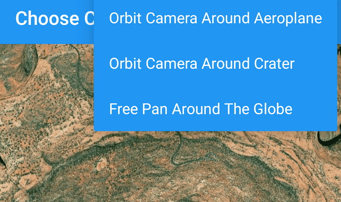
The application loads with the default globe camera controller. To rotate and fix the scene around the plane, exit globe mode by choosing the "Orbit camera around plane" option (i.e. camera will now be fixed to the plane). Choose the "Orbit camera around location" option to rotate and center the scene around the location of the Upheaval Dome crater structure, or choose the "Free pan round the globe" option to return to default free navigation.
How it works
- Create an instance of a class extending
CameraController:GlobeCameraController,OrbitLocationCameraController,OrbitGeoElementCameraController. - Set the scene view's camera controller with
sceneView.setCameraController(cameraController).
Relevant API
- ArcGISScene
- Camera
- GlobeCameraController
- OrbitGeoElementCameraController
- OrbitLocationCameraController
- SceneView
Tags
3D, camera, camera controller
Sample Code
/*
* Copyright 2019 Esri
*
* Licensed under the Apache License, Version 2.0 (the "License");
* you may not use this file except in compliance with the License.
* You may obtain a copy of the License at
*
* http://www.apache.org/licenses/LICENSE-2.0
*
* Unless required by applicable law or agreed to in writing, software
* distributed under the License is distributed on an "AS IS" BASIS,
* WITHOUT WARRANTIES OR CONDITIONS OF ANY KIND, either express or implied.
* See the License for the specific language governing permissions and
* limitations under the License.
*/
package com.esri.arcgisruntime.sample.choosecameracontroller;
import java.io.BufferedInputStream;
import java.io.BufferedOutputStream;
import java.io.File;
import java.io.FileOutputStream;
import android.content.res.AssetManager;
import android.os.Bundle;
import androidx.core.content.ContextCompat;
import androidx.appcompat.app.AppCompatActivity;
import androidx.appcompat.widget.Toolbar;
import android.util.Log;
import android.view.Menu;
import android.view.MenuItem;
import com.esri.arcgisruntime.ArcGISRuntimeEnvironment;
import com.esri.arcgisruntime.geometry.Point;
import com.esri.arcgisruntime.geometry.SpatialReferences;
import com.esri.arcgisruntime.mapping.ArcGISScene;
import com.esri.arcgisruntime.mapping.ArcGISTiledElevationSource;
import com.esri.arcgisruntime.mapping.Basemap;
import com.esri.arcgisruntime.mapping.BasemapStyle;
import com.esri.arcgisruntime.mapping.Surface;
import com.esri.arcgisruntime.mapping.view.Camera;
import com.esri.arcgisruntime.mapping.view.GlobeCameraController;
import com.esri.arcgisruntime.mapping.view.Graphic;
import com.esri.arcgisruntime.mapping.view.GraphicsOverlay;
import com.esri.arcgisruntime.mapping.view.LayerSceneProperties;
import com.esri.arcgisruntime.mapping.view.OrbitGeoElementCameraController;
import com.esri.arcgisruntime.mapping.view.OrbitLocationCameraController;
import com.esri.arcgisruntime.mapping.view.SceneView;
import com.esri.arcgisruntime.symbology.ModelSceneSymbol;
public class MainActivity extends AppCompatActivity {
private static final String TAG = MainActivity.class.getSimpleName();
private SceneView mSceneView;
private Graphic mPlane3D;
private GraphicsOverlay mSceneOverlay;
private OrbitGeoElementCameraController mOrbitPlaneCameraController;
private OrbitLocationCameraController mOrbitLocationCameraController;
@Override
protected void onCreate(Bundle savedInstanceState) {
super.onCreate(savedInstanceState);
setContentView(R.layout.activity_main);
// authentication with an API key or named user is required to access basemaps and other
// location services
ArcGISRuntimeEnvironment.setApiKey(BuildConfig.API_KEY);
// load plane model from assets into cache directory
copyFileFromAssetsToCache(getString(R.string.bristol_model));
copyFileFromAssetsToCache(getString(R.string.bristol_skin));
setupToolbar();
// create a scene and add it to the scene view
mSceneView = findViewById(R.id.sceneView);
ArcGISScene scene = new ArcGISScene(BasemapStyle.ARCGIS_IMAGERY);
mSceneView.setScene(scene);
// add base surface for elevation data
Surface surface = new Surface();
ArcGISTiledElevationSource elevationSource = new ArcGISTiledElevationSource(
getString(R.string.world_elevation_service_url));
surface.getElevationSources().add(elevationSource);
scene.setBaseSurface(surface);
// create a graphics overlay for the scene
mSceneOverlay = new GraphicsOverlay();
mSceneOverlay.getSceneProperties().setSurfacePlacement(LayerSceneProperties.SurfacePlacement.ABSOLUTE);
mSceneView.getGraphicsOverlays().add(mSceneOverlay);
// create a camera and set it as the viewpoint for when the scene loads
Camera camera = new Camera(38.459291, -109.937576, 5500, 150.0, 20.0, 0.0);
mSceneView.setViewpointCamera(camera);
// instantiate a new camera controller which orbits a target location
Point locationPoint = new Point(-109.929589, 38.437304, 1700, SpatialReferences.getWgs84());
mOrbitLocationCameraController = new OrbitLocationCameraController(locationPoint, 5000);
mOrbitLocationCameraController.setCameraPitchOffset(3);
mOrbitLocationCameraController.setCameraHeadingOffset(150);
loadModel().addDoneLoadingListener(() -> {
// instantiate a new camera controller which orbits the plane at a set distance
mOrbitPlaneCameraController = new OrbitGeoElementCameraController(mPlane3D, 100.0);
mOrbitPlaneCameraController.setCameraPitchOffset(30);
mOrbitPlaneCameraController.setCameraHeadingOffset(150);
});
}
private void setupToolbar() {
Toolbar toolbar = findViewById(R.id.toolbar);
setSupportActionBar(toolbar);
toolbar.setOverflowIcon(ContextCompat.getDrawable(this, R.drawable.ic_photo_camera));
}
@Override public boolean onCreateOptionsMenu(Menu menu) {
getMenuInflater().inflate(R.menu.camera_controller_menu, menu);
return super.onCreateOptionsMenu(menu);
}
@Override public boolean onOptionsItemSelected(MenuItem item) {
int itemid = item.getItemId();
if (itemid == R.id.action_camera_controller_plane) {
mSceneView.setCameraController(mOrbitPlaneCameraController);
return true;
} else if (itemid == R.id.action_camera_controller_crater) {
mSceneView.setCameraController(mOrbitLocationCameraController);
return true;
} else if (itemid == R.id.action_camera_controller_globe) {
mSceneView.setCameraController(new GlobeCameraController());
return true;
}
return super.onOptionsItemSelected(item);
}
/**
* Load the plane model from the cache, use to construct a Model Scene Symbol and add it to the scene's graphic overlay.
*/
private ModelSceneSymbol loadModel() {
// create a graphic with a ModelSceneSymbol of a plane to add to the scene
String pathToModel = getCacheDir() + File.separator + getString(R.string.bristol_model);
ModelSceneSymbol plane3DSymbol = new ModelSceneSymbol(pathToModel, 1.0);
plane3DSymbol.setHeading(45);
mPlane3D = new Graphic(new Point(-109.937516, 38.456714, 5000, SpatialReferences.getWgs84()), plane3DSymbol);
mSceneOverlay.getGraphics().add(mPlane3D);
return plane3DSymbol;
}
/**
* Copy the given file from the app's assets folder to the app's cache directory.
*
* @param fileName as String
*/
private void copyFileFromAssetsToCache(String fileName) {
AssetManager assetManager = getApplicationContext().getAssets();
File file = new File(getCacheDir() + File.separator + fileName);
if (!file.exists()) {
try {
BufferedInputStream bis = new BufferedInputStream(assetManager.open(fileName));
BufferedOutputStream bos = new BufferedOutputStream(
new FileOutputStream(getCacheDir() + File.separator + fileName));
byte[] buffer = new byte[bis.available()];
int read = bis.read(buffer);
while (read != -1) {
bos.write(buffer, 0, read);
read = bis.read(buffer);
}
bos.close();
bis.close();
Log.i(TAG, fileName + " copied to cache.");
} catch (Exception e) {
Log.e(TAG, "Error writing " + fileName + " to cache. " + e.getMessage());
}
} else {
Log.i(TAG, fileName + " already in cache.");
}
}
@Override
protected void onResume() {
super.onResume();
mSceneView.resume();
}
@Override
protected void onPause() {
mSceneView.pause();
super.onPause();
}
@Override
protected void onDestroy() {
mSceneView.dispose();
super.onDestroy();
}
}