A multipart geometry can be densified by adding interpolated points at regular intervals. Generalizing multipart geometry simplifies it while preserving its general shape. Densifying a multipart geometry adds more vertices at regular intervals.
Use case
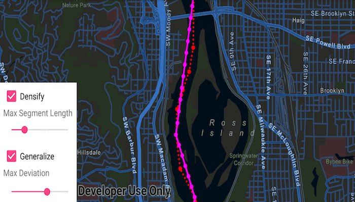
The sample shows a polyline representing a ship's location at irregular intervals. The density of vertices along the ship's route is appropriate to represent the path of the ship at the sample map view's initial scale. However, that level of detail may be too great if you wanted to show a polyline of the ship's movement down the whole of the Willamette river. Then, you might consider generalizing the polyline to still faithfully represent the ship's passage on the river without having an overly complicated geometry.
Densifying a multipart geometry can be used to more accurately represent curved lines or to add more regularity to the vertices making up a multipart geometry.
How to use the sample
Use the sliders to control the parameters of the densify and generalize methods. You can deselect the checkboxes for either method to remove its effect from the result polyline.
How it works
- Use the static method
GeometryEngine.densify(polyline, maxSegmentLength)to densify the polyline object. The resulting polyline object will have more points along the line, so that there are no points greater thanmaxSegmentLengthfrom the next point. - Use the static method
GeometryEngine.generalize(polyline, maxDeviation, true)to generalize the polyline object. The resulting polyline object will have points shifted from the original line to simplify the shape. None of these points can deviate farther from the original line thanmaxDeviation. The last parameter,removeDegenerateParts, will clean up extraneous parts of a multipart geometry. This will have no effect in this sample as the polyline does not contain extraneous parts. - Note that
maxSegmentLengthandmaxDeviationare in the units of the geometry's coordinate system. In this example, a cartesian coordinate system is used and at a small enough scale that geodesic distances are not required.
Relevant API
- GeometryEngine
- Multipoint
- Point
- PointCollection
- Polyline
- SimpleLineSymbol
- SpatialReference
Tags
densify, Edit and Manage Data, generalize, simplify
Sample Code
/* Copyright 2018 Esri
*
* Licensed under the Apache License, Version 2.0 (the "License");
* you may not use this file except in compliance with the License.
* You may obtain a copy of the License at
*
* http://www.apache.org/licenses/LICENSE-2.0
*
* Unless required by applicable law or agreed to in writing, software
* distributed under the License is distributed on an "AS IS" BASIS,
* WITHOUT WARRANTIES OR CONDITIONS OF ANY KIND, either express or implied.
* See the License for the specific language governing permissions and
* limitations under the License.
*
*/
package com.esri.arcgisruntime.sample.densifygeneralize;
import android.os.Bundle;
import android.widget.CheckBox;
import android.widget.SeekBar;
import androidx.appcompat.app.AppCompatActivity;
import com.esri.arcgisruntime.ArcGISRuntimeEnvironment;
import com.esri.arcgisruntime.geometry.GeometryEngine;
import com.esri.arcgisruntime.geometry.Multipoint;
import com.esri.arcgisruntime.geometry.Point;
import com.esri.arcgisruntime.geometry.PointCollection;
import com.esri.arcgisruntime.geometry.Polyline;
import com.esri.arcgisruntime.geometry.SpatialReference;
import com.esri.arcgisruntime.mapping.ArcGISMap;
import com.esri.arcgisruntime.mapping.Basemap;
import com.esri.arcgisruntime.mapping.BasemapStyle;
import com.esri.arcgisruntime.mapping.view.Graphic;
import com.esri.arcgisruntime.mapping.view.GraphicsOverlay;
import com.esri.arcgisruntime.mapping.view.MapView;
import com.esri.arcgisruntime.symbology.SimpleLineSymbol;
import com.esri.arcgisruntime.symbology.SimpleMarkerSymbol;
public class MainActivity extends AppCompatActivity {
private MapView mMapView;
private SeekBar mMaxSegmentLengthSlider;
private SeekBar mMaxDeviationSlider;
private CheckBox mDensifyCheckBox;
private CheckBox mGeneralizeCheckBox;
private Graphic mResultPointGraphic;
private Graphic mResultPolylineGraphic;
private Polyline mOriginalPolyline;
@Override
protected void onCreate(Bundle savedInstanceState) {
super.onCreate(savedInstanceState);
setContentView(R.layout.activity_main);
// authentication with an API key or named user is required to access basemaps and other
// location services
ArcGISRuntimeEnvironment.setApiKey(BuildConfig.API_KEY);
// inflate MapView from layout
mMapView = findViewById(R.id.mapView);
// create a map with a basemap
ArcGISMap map = new ArcGISMap(BasemapStyle.ARCGIS_STREETS_NIGHT);
// set the map to be displayed in this view
mMapView.setMap(map);
// inflate views from layout
mMaxSegmentLengthSlider = findViewById(R.id.maxSegmentLengthBar);
mMaxDeviationSlider = findViewById(R.id.maxDeviationBar);
mDensifyCheckBox = findViewById(R.id.densifyCheckBox);
mGeneralizeCheckBox = findViewById(R.id.generalizeCheckBox);
// create graphics overlay
GraphicsOverlay graphicsOverlay = new GraphicsOverlay();
mMapView.getGraphicsOverlays().add(graphicsOverlay);
// create some points along a river for the original geometry
PointCollection points = createShipPoints();
// show the original points as red dots on the map
Multipoint originalMultipoint = new Multipoint(points);
Graphic originalPointsGraphic = new Graphic(originalMultipoint,
new SimpleMarkerSymbol(SimpleMarkerSymbol.Style.CIRCLE, 0xFFFF0000, 7));
graphicsOverlay.getGraphics().add(originalPointsGraphic);
// show a dotted red line connecting the original points
mOriginalPolyline = new Polyline(points);
Graphic originalPolylineGraphic = new Graphic(mOriginalPolyline, new SimpleLineSymbol(SimpleLineSymbol.Style.DOT,
0xFFFF0000, 3));
graphicsOverlay.getGraphics().add(originalPolylineGraphic);
// show the result (densified and generalized) point as magenta dots on the map
mResultPointGraphic = new Graphic();
mResultPointGraphic.setSymbol(new SimpleMarkerSymbol(SimpleMarkerSymbol.Style.CIRCLE, 0xFFFF00FF, 7));
graphicsOverlay.getGraphics().add(mResultPointGraphic);
// connect the results points with a magenta line
mResultPolylineGraphic = new Graphic();
mResultPolylineGraphic.setSymbol(new SimpleLineSymbol(SimpleLineSymbol.Style.SOLID, 0xFFFF00FF, 3));
graphicsOverlay.getGraphics().add(mResultPolylineGraphic);
mMapView.setViewpointGeometryAsync(mOriginalPolyline.getExtent(), 100);
// set defaults
mMaxDeviationSlider.setMax(249);
mMaxSegmentLengthSlider.setMax(400);
mGeneralizeCheckBox.setChecked(true);
mDensifyCheckBox.setChecked(true);
setListeners();
updateGeometry();
}
/**
* Adds listeners to both seek bars and both check boxes.
*/
private void setListeners() {
mMaxDeviationSlider.setOnSeekBarChangeListener(new SeekBar.OnSeekBarChangeListener() {
@Override public void onProgressChanged(SeekBar seekBar, int progress, boolean fromUser) {
updateGeometry();
}
@Override public void onStartTrackingTouch(SeekBar seekBar) {
}
@Override public void onStopTrackingTouch(SeekBar seekBar) {
}
});
mMaxSegmentLengthSlider.setOnSeekBarChangeListener(new SeekBar.OnSeekBarChangeListener() {
@Override public void onProgressChanged(SeekBar seekBar, int progress, boolean fromUser) {
updateGeometry();
}
@Override public void onStartTrackingTouch(SeekBar seekBar) {
}
@Override public void onStopTrackingTouch(SeekBar seekBar) {
}
});
mGeneralizeCheckBox.setOnClickListener(v -> updateGeometry());
mDensifyCheckBox.setOnClickListener(v -> updateGeometry());
}
/**
* Called when any of the densify/generalize option values are changed. Applies the densify and generalize
* operations to the original polyline and updates the result graphics with the result geometry.
*/
private void updateGeometry() {
Polyline tempPolyline = mOriginalPolyline;
if (mGeneralizeCheckBox.isChecked()) {
tempPolyline = (Polyline) GeometryEngine.generalize(tempPolyline, mMaxDeviationSlider.getProgress() + 1,
true);
}
if (mDensifyCheckBox.isChecked()) {
tempPolyline = (Polyline) GeometryEngine.densify(tempPolyline, mMaxSegmentLengthSlider.getProgress() + 100);
}
mResultPolylineGraphic.setGeometry(tempPolyline);
Multipoint multipoint = new Multipoint(tempPolyline.getParts().getPartsAsPoints());
mResultPointGraphic.setGeometry(multipoint);
}
/**
* Creates a collection of points along the Willamette River in Portland, OR.
*
* @return points
*/
private static PointCollection createShipPoints() {
PointCollection points = new PointCollection(SpatialReference.create(32126));
points.add(new Point(2330611.130549, 202360.002957, 0.000000));
points.add(new Point(2330583.834672, 202525.984012, 0.000000));
points.add(new Point(2330574.164902, 202691.488009, 0.000000));
points.add(new Point(2330689.292623, 203170.045888, 0.000000));
points.add(new Point(2330696.773344, 203317.495798, 0.000000));
points.add(new Point(2330691.419723, 203380.917080, 0.000000));
points.add(new Point(2330435.065296, 203816.662457, 0.000000));
points.add(new Point(2330369.500800, 204329.861789, 0.000000));
points.add(new Point(2330400.929891, 204712.129673, 0.000000));
points.add(new Point(2330484.300447, 204927.797132, 0.000000));
points.add(new Point(2330514.469919, 205000.792463, 0.000000));
points.add(new Point(2330638.099138, 205271.601116, 0.000000));
points.add(new Point(2330725.315888, 205631.231308, 0.000000));
points.add(new Point(2330755.640702, 206433.354860, 0.000000));
points.add(new Point(2330680.644719, 206660.240923, 0.000000));
points.add(new Point(2330386.957926, 207340.947204, 0.000000));
points.add(new Point(2330485.861737, 207742.298501, 0.000000));
return points;
}
@Override
protected void onPause() {
super.onPause();
mMapView.pause();
}
@Override
protected void onResume() {
super.onResume();
mMapView.resume();
}
@Override
protected void onDestroy() {
super.onDestroy();
mMapView.dispose();
}
}