Show a line of sight between two moving objects.
Use case
A line of sight between geoelements (i.e. observer and target) will not remain constant whilst one or both are on the move.
A line of sight is therefore useful in cases where visibility between two geoelements requires monitoring over a period of time in a partially obstructed field of view (such as buildings in a city).
How to use the sample
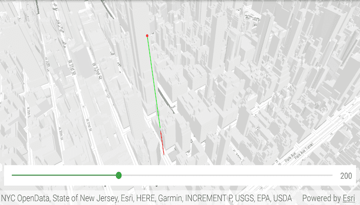
A line of sight will display between a point on the Empire State Building (observer) and a taxi (target). The taxi will drive around a block and the line of sight should automatically update. The taxi will be highlighted and blinking when it is visible. A red segment on the line means the view between observer and target is obstructed, whereas cyan means the view is unobstructed. You can change the observer height with the slider to see how it affects the target's visibility.
How it works
- Instantiate an
AnalysisOverlayand add it to theSceneView's analysis overlays collection. - Instantiate a
GeoElementLineOfSight, passing in observer and targetGeoElements (features or graphics). Add the line of sight to the analysis overlay's analyses collection. - To get the target visibility when it changes, react to the target visibility changing on the
GeoElementLineOfSightinstance.
Relevant API
- AnalysisOverlay
- GeoElementLineOfSight
- LineOfSight.TargetVisibility
Tags
3D, line of sight, visibility, visibility analysis
Sample Code
/* Copyright 2018 Esri
*
* Licensed under the Apache License, Version 2.0 (the "License");
* you may not use this file except in compliance with the License.
* You may obtain a copy of the License at
*
* http://www.apache.org/licenses/LICENSE-2.0
*
* Unless required by applicable law or agreed to in writing, software
* distributed under the License is distributed on an "AS IS" BASIS,
* WITHOUT WARRANTIES OR CONDITIONS OF ANY KIND, either express or implied.
* See the License for the specific language governing permissions and
* limitations under the License.
*
*/
package com.esri.arcgisruntime.sample.lineofsightgeoelement;
import java.io.File;
import java.io.FileOutputStream;
import java.io.InputStream;
import java.io.OutputStream;
import java.util.Arrays;
import java.util.List;
import java.util.Timer;
import java.util.TimerTask;
import android.content.res.AssetManager;
import android.os.Bundle;
import androidx.appcompat.app.AppCompatActivity;
import android.util.Log;
import android.widget.SeekBar;
import android.widget.TextView;
import com.esri.arcgisruntime.ArcGISRuntimeEnvironment;
import com.esri.arcgisruntime.geoanalysis.GeoElementLineOfSight;
import com.esri.arcgisruntime.geoanalysis.LineOfSight;
import com.esri.arcgisruntime.geometry.AngularUnit;
import com.esri.arcgisruntime.geometry.AngularUnitId;
import com.esri.arcgisruntime.geometry.GeodeticCurveType;
import com.esri.arcgisruntime.geometry.GeodeticDistanceResult;
import com.esri.arcgisruntime.geometry.GeometryEngine;
import com.esri.arcgisruntime.geometry.LinearUnit;
import com.esri.arcgisruntime.geometry.LinearUnitId;
import com.esri.arcgisruntime.geometry.Point;
import com.esri.arcgisruntime.geometry.PointBuilder;
import com.esri.arcgisruntime.geometry.SpatialReferences;
import com.esri.arcgisruntime.layers.ArcGISSceneLayer;
import com.esri.arcgisruntime.mapping.ArcGISScene;
import com.esri.arcgisruntime.mapping.ArcGISTiledElevationSource;
import com.esri.arcgisruntime.mapping.Basemap;
import com.esri.arcgisruntime.mapping.BasemapStyle;
import com.esri.arcgisruntime.mapping.Surface;
import com.esri.arcgisruntime.mapping.view.AnalysisOverlay;
import com.esri.arcgisruntime.mapping.view.Camera;
import com.esri.arcgisruntime.mapping.view.Graphic;
import com.esri.arcgisruntime.mapping.view.GraphicsOverlay;
import com.esri.arcgisruntime.mapping.view.LayerSceneProperties;
import com.esri.arcgisruntime.mapping.view.SceneView;
import com.esri.arcgisruntime.symbology.ModelSceneSymbol;
import com.esri.arcgisruntime.symbology.Renderer;
import com.esri.arcgisruntime.symbology.SceneSymbol;
import com.esri.arcgisruntime.symbology.SimpleMarkerSymbol;
import com.esri.arcgisruntime.symbology.SimpleRenderer;
public class MainActivity extends AppCompatActivity {
private static final String TAG = MainActivity.class.getSimpleName();
private static final LinearUnit METERS = new LinearUnit(LinearUnitId.METERS);
private static final AngularUnit DEGREES = new AngularUnit(AngularUnitId.DEGREES);
private int mWaypointIndex = 0;
private SceneView mSceneView;
private Graphic mTaxiGraphic;
private List<Point> mWaypoints;
@Override
protected void onCreate(Bundle savedInstanceState) {
super.onCreate(savedInstanceState);
setContentView(R.layout.activity_main);
// authentication with an API key or named user is required to access basemaps and other
// location services
ArcGISRuntimeEnvironment.setApiKey(BuildConfig.API_KEY);
// load taxi model from assets into cache directory
copyFileFromAssetsToCache(getString(R.string.dolmus_model));
copyFileFromAssetsToCache(getString(R.string.dolmus_back));
copyFileFromAssetsToCache(getString(R.string.dolmus_front));
copyFileFromAssetsToCache(getString(R.string.dolmus_side));
copyFileFromAssetsToCache(getString(R.string.tire_tread));
// create a scene and add a basemap to it
ArcGISScene scene = new ArcGISScene(BasemapStyle.ARCGIS_TOPOGRAPHIC);
// get a reference to the scene view and set the scene to it
mSceneView = findViewById(R.id.sceneView);
mSceneView.setScene(scene);
// add base surface for elevation data
Surface surface = new Surface();
surface.getElevationSources().add(new ArcGISTiledElevationSource(getString(R.string.elevation_service_url)));
scene.setBaseSurface(surface);
// add buildings from New York City
String buildingsURL = getString(R.string.new_york_buildings_service_url);
ArcGISSceneLayer buildings = new ArcGISSceneLayer(buildingsURL);
scene.getOperationalLayers().add(buildings);
// create a graphics overlay for the graphics
GraphicsOverlay graphicsOverlay = new GraphicsOverlay();
graphicsOverlay.getSceneProperties().setSurfacePlacement(LayerSceneProperties.SurfacePlacement.RELATIVE);
mSceneView.getGraphicsOverlays().add(graphicsOverlay);
// set up a heading expression to handle graphic rotation
SimpleRenderer renderer3D = new SimpleRenderer();
Renderer.SceneProperties renderProperties = renderer3D.getSceneProperties();
renderProperties.setHeadingExpression("[HEADING]");
graphicsOverlay.setRenderer(renderer3D);
// create a point graph near the Empire State Building to be the observer
Point observationPoint = new Point(-73.9853, 40.7484, 200, SpatialReferences.getWgs84());
Graphic observer = new Graphic(observationPoint,
new SimpleMarkerSymbol(SimpleMarkerSymbol.Style.CIRCLE, 0xFFFF0000, 5));
graphicsOverlay.getGraphics().add(observer);
// create a slider to change the observer's Z value
SeekBar heightSeekBar = findViewById(R.id.heightSeekBar);
TextView currHeightTextView = findViewById(R.id.currHeightTextView);
// offset the minimum height of the observer on the seek bar
int seekBarMinHeightOffset = 150;
heightSeekBar.setMax(seekBarMinHeightOffset);
heightSeekBar.setOnSeekBarChangeListener(new SeekBar.OnSeekBarChangeListener() {
@Override public void onProgressChanged(SeekBar seekBar, int progress, boolean b) {
// use the offset to calculate the height value
int height = progress + seekBarMinHeightOffset;
currHeightTextView.setText(String.valueOf(height));
PointBuilder pointBuilder = new PointBuilder((Point) observer.getGeometry());
pointBuilder.setZ(height);
observer.setGeometry(pointBuilder.toGeometry());
}
@Override public void onStartTrackingTouch(SeekBar seekBar) {
}
@Override public void onStopTrackingTouch(SeekBar seekBar) {
}
});
// set seek bar initial progress with offset
heightSeekBar.setProgress((int) observationPoint.getZ() - seekBarMinHeightOffset);
// create waypoints around a block for the taxi to drive to
mWaypoints = Arrays.asList(
new Point(-73.984513, 40.748469, SpatialReferences.getWgs84()),
new Point(-73.985068, 40.747786, SpatialReferences.getWgs84()),
new Point(-73.983452, 40.747091, SpatialReferences.getWgs84()),
new Point(-73.982961, 40.747762, SpatialReferences.getWgs84())
);
// create a graphic of a taxi to be the target
String pathToModel = getCacheDir() + File.separator + getString(R.string.dolmus_model);
ModelSceneSymbol taxiSymbol = new ModelSceneSymbol(pathToModel, 1.0);
taxiSymbol.setAnchorPosition(SceneSymbol.AnchorPosition.BOTTOM);
taxiSymbol.loadAsync();
mTaxiGraphic = new Graphic(mWaypoints.get(0), taxiSymbol);
mTaxiGraphic.getAttributes().put("HEADING", 0.0);
graphicsOverlay.getGraphics().add(mTaxiGraphic);
// create an analysis overlay to hold the line of sight
AnalysisOverlay analysisOverlay = new AnalysisOverlay();
mSceneView.getAnalysisOverlays().add(analysisOverlay);
// create a line of sight between the two graphics and add it to the analysis overlay
GeoElementLineOfSight lineOfSight = new GeoElementLineOfSight(observer, mTaxiGraphic);
analysisOverlay.getAnalyses().add(lineOfSight);
// select (highlight) the taxi when the line of sight target visibility changes to visible
lineOfSight.addTargetVisibilityChangedListener(targetVisibilityChangedEvent -> mTaxiGraphic
.setSelected(targetVisibilityChangedEvent.getTargetVisibility() == LineOfSight.TargetVisibility.VISIBLE)
);
// create a timer to animate the tank
Timer timer = new Timer();
timer.scheduleAtFixedRate(new TimerTask() {
@Override public void run() {
animate();
}
}, 0, 50);
// zoom to show the observer
Camera camera = new Camera((Point) observer.getGeometry(), 700, -30, 45, 0);
mSceneView.setViewpointCamera(camera);
}
/**
* Moves the taxi toward the current waypoint a short distance.
*/
private void animate() {
Point waypoint = mWaypoints.get(mWaypointIndex);
// get current location and distance from waypoint
Point location = (Point) mTaxiGraphic.getGeometry();
GeodeticDistanceResult distance = GeometryEngine.distanceGeodetic(location, waypoint, METERS, DEGREES,
GeodeticCurveType.GEODESIC);
// move toward waypoint a short distance
location = GeometryEngine.moveGeodetic(location, 1.0, METERS, distance.getAzimuth1(), DEGREES,
GeodeticCurveType.GEODESIC);
mTaxiGraphic.setGeometry(location);
// rotate to the waypoint
mTaxiGraphic.getAttributes().put("HEADING", distance.getAzimuth1());
// reached waypoint, move to next waypoint
if (distance.getDistance() <= 2) {
mWaypointIndex = (mWaypointIndex + 1) % mWaypoints.size();
}
}
/**
* Copy the given file from the app's assets folder to the app's cache directory.
*
* @param fileName as String
*/
private void copyFileFromAssetsToCache(String fileName) {
AssetManager assetManager = getApplicationContext().getAssets();
File file = new File(getCacheDir() + File.separator + fileName);
if (!file.exists()) {
try {
InputStream in = assetManager.open(fileName);
OutputStream out = new FileOutputStream(getCacheDir() + File.separator + fileName);
byte[] buffer = new byte[1024];
int read = in.read(buffer);
while (read != -1) {
out.write(buffer, 0, read);
read = in.read(buffer);
}
Log.i(TAG, fileName + " copied to cache.");
} catch (Exception e) {
Log.e(TAG, "Error writing " + fileName + " to cache. " + e.getMessage());
}
} else {
Log.i(TAG, fileName + " already in cache.");
}
}
@Override
protected void onPause() {
mSceneView.pause();
super.onPause();
}
@Override
protected void onResume() {
super.onResume();
mSceneView.resume();
}
@Override
protected void onDestroy() {
mSceneView.dispose();
super.onDestroy();
}
}