Analyze the viewshed for an object (GeoElement) in a scene.
Use case
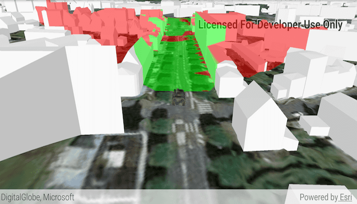
A viewshed analysis is a type of visual analysis you can perform on a scene. The viewshed aims to answer the question 'What can I see from a given location?'. The output is an overlay with two different colors - one representing the visible areas (green) and the other representing the obstructed areas (red).
How to use the sample
Tap to set a destination for the vehicle (a GeoElement). The vehicle will 'drive' towards the tapped location. The viewshed analysis will update as the vehicle moves.
How it works
- Create and show the scene, with an elevation source and a buildings layer.
- Add a model (the
GeoElement) to represent the observer (in this case, a tank).- Use a
SimpleRendererwhich has a heading expression set in theGraphicsOverlay. This way you can relate the viewshed's heading to theGeoElementobject's heading.
- Use a
- Create a
GeoElementViewshedwith configuration for the viewshed analysis. - Add the viewshed to an
AnalysisOverlayand add the overlay to the scene. - Configure the SceneView
CameraControllerto orbit the vehicle.
About the data
This sample shows a Johannesburg, South Africa Scene from ArcGIS Online. The sample uses a Tank model scene symbol hosted as an item on ArcGIS Online.
Relevant API
- AnalysisOverlay
- GeodeticDistanceResult
- GeoElementViewshed
- GeometryEngine.distanceGeodetic (used to animate the vehicle)
- ModelSceneSymbol
- OrbitGeoElementCameraController
Tags
3D, analysis, buildings, model, scene, viewshed, visibility analysis
Sample Code
/* Copyright 2018 ESRI
*
* All rights reserved under the copyright laws of the United States
* and applicable international laws, treaties, and conventions.
*
* You may freely redistribute and use this sample code, with or
* without modification, provided you include the original copyright
* notice and use restrictions.
*
* See the Sample code usage restrictions document for further information.
*
*/
package com.esri.arcgisruntime.sample.viewshedgeoelement;
import java.io.File;
import java.io.FileOutputStream;
import java.io.InputStream;
import java.io.OutputStream;
import java.util.Timer;
import java.util.TimerTask;
import android.Manifest;
import android.content.pm.PackageManager;
import android.content.res.AssetManager;
import android.os.Bundle;
import androidx.annotation.NonNull;
import androidx.core.app.ActivityCompat;
import androidx.core.content.ContextCompat;
import androidx.appcompat.app.AppCompatActivity;
import android.util.Log;
import android.view.MotionEvent;
import android.widget.Toast;
import com.esri.arcgisruntime.ArcGISRuntimeEnvironment;
import com.esri.arcgisruntime.geoanalysis.GeoElementViewshed;
import com.esri.arcgisruntime.geometry.AngularUnit;
import com.esri.arcgisruntime.geometry.AngularUnitId;
import com.esri.arcgisruntime.geometry.GeodeticCurveType;
import com.esri.arcgisruntime.geometry.GeodeticDistanceResult;
import com.esri.arcgisruntime.geometry.GeometryEngine;
import com.esri.arcgisruntime.geometry.LinearUnit;
import com.esri.arcgisruntime.geometry.LinearUnitId;
import com.esri.arcgisruntime.geometry.Point;
import com.esri.arcgisruntime.geometry.SpatialReferences;
import com.esri.arcgisruntime.layers.ArcGISSceneLayer;
import com.esri.arcgisruntime.mapping.ArcGISScene;
import com.esri.arcgisruntime.mapping.ArcGISTiledElevationSource;
import com.esri.arcgisruntime.mapping.Basemap;
import com.esri.arcgisruntime.mapping.BasemapStyle;
import com.esri.arcgisruntime.mapping.Surface;
import com.esri.arcgisruntime.mapping.view.AnalysisOverlay;
import com.esri.arcgisruntime.mapping.view.DefaultSceneViewOnTouchListener;
import com.esri.arcgisruntime.mapping.view.Graphic;
import com.esri.arcgisruntime.mapping.view.GraphicsOverlay;
import com.esri.arcgisruntime.mapping.view.LayerSceneProperties;
import com.esri.arcgisruntime.mapping.view.OrbitGeoElementCameraController;
import com.esri.arcgisruntime.mapping.view.SceneView;
import com.esri.arcgisruntime.symbology.ModelSceneSymbol;
import com.esri.arcgisruntime.symbology.Renderer;
import com.esri.arcgisruntime.symbology.SceneSymbol;
import com.esri.arcgisruntime.symbology.SimpleRenderer;
public class MainActivity extends AppCompatActivity {
private static final String TAG = MainActivity.class.getSimpleName();
private static final LinearUnit METERS = new LinearUnit(LinearUnitId.METERS);
private static final AngularUnit DEGREES = new AngularUnit(AngularUnitId.DEGREES);
private SceneView mSceneView;
private Point mWaypoint;
private Graphic mTankGraphic;
private Timer mTimer;
@Override
protected void onCreate(Bundle savedInstanceState) {
super.onCreate(savedInstanceState);
setContentView(R.layout.activity_main);
// authentication with an API key or named user is required to access basemaps and other
// location services
ArcGISRuntimeEnvironment.setApiKey(BuildConfig.API_KEY);
// create a scene and add a basemap to it
ArcGISScene scene = new ArcGISScene(BasemapStyle.ARCGIS_IMAGERY);
// add the SceneView to the stack pane
mSceneView = findViewById(R.id.sceneView);
mSceneView.setScene(scene);
// add base surface for elevation data
Surface surface = new Surface();
surface.getElevationSources().add(new ArcGISTiledElevationSource(getString(R.string.elevation_service)));
scene.setBaseSurface(surface);
// add a scene layer
ArcGISSceneLayer sceneLayer = new ArcGISSceneLayer(getString(R.string.buildings_layer));
scene.getOperationalLayers().add(sceneLayer);
// request read permission
requestWritePermission();
}
/**
* Creates a GeoElement Viewshed fixed to a graphic of a tank. Includes a touch listener which uses a single tap as a
* waypoint for navigation of the tank and associated viewshed.
*/
private void viewshedGeoElement() {
// load tank model from assets into cache directory
copyFileFromAssetsToCache(getString(R.string.bradley_model));
copyFileFromAssetsToCache(getString(R.string.bradley_skin));
// create a graphics overlay for the tank
GraphicsOverlay graphicsOverlay = new GraphicsOverlay();
graphicsOverlay.getSceneProperties().setSurfacePlacement(LayerSceneProperties.SurfacePlacement.RELATIVE);
mSceneView.getGraphicsOverlays().add(graphicsOverlay);
// set up heading expression for tank
SimpleRenderer renderer3D = new SimpleRenderer();
Renderer.SceneProperties renderProperties = renderer3D.getSceneProperties();
renderProperties.setHeadingExpression("[HEADING]");
graphicsOverlay.setRenderer(renderer3D);
String pathToModel = getCacheDir() + File.separator + getString(R.string.bradley_model);
ModelSceneSymbol tankSymbol = new ModelSceneSymbol(pathToModel, 10.0);
tankSymbol.setHeading(90);
tankSymbol.setAnchorPosition(SceneSymbol.AnchorPosition.BOTTOM);
mTankGraphic = new Graphic(new Point(-4.506390, 48.385624, SpatialReferences.getWgs84()), tankSymbol);
mTankGraphic.getAttributes().put("HEADING", 0.0);
graphicsOverlay.getGraphics().add(mTankGraphic);
// create a viewshed to attach to the tank
GeoElementViewshed geoElementViewshed = new GeoElementViewshed(mTankGraphic, 90.0, 40.0, 0.1, 250.0, 0.0, 0.0);
// offset viewshed observer location to top of tank
geoElementViewshed.setOffsetZ(3.0);
// create an analysis overlay to add the viewshed to the scene view
AnalysisOverlay analysisOverlay = new AnalysisOverlay();
analysisOverlay.getAnalyses().add(geoElementViewshed);
mSceneView.getAnalysisOverlays().add(analysisOverlay);
// set the waypoint where the user taps
mSceneView.setOnTouchListener(new DefaultSceneViewOnTouchListener(mSceneView) {
@Override public boolean onSingleTapConfirmed(MotionEvent motionEvent) {
// get a screen point from the motion event
android.graphics.Point screenPoint = new android.graphics.Point(Math.round(motionEvent.getX()),
Math.round(motionEvent.getY()));
// convert the screen point to a scene point
mWaypoint = mSceneView.screenToBaseSurface(screenPoint);
// create a timer to animate the tank
mTimer = new Timer();
mTimer.scheduleAtFixedRate(new TimerTask() {
@Override public void run() {
animate();
}
}, 0, 50);
return true;
}
});
// set camera controller to follow tank
OrbitGeoElementCameraController cameraController = new OrbitGeoElementCameraController(mTankGraphic, 200.0);
cameraController.setCameraPitchOffset(45.0);
mSceneView.setCameraController(cameraController);
}
/**
* Moves the tank toward the current waypoint a short distance.
*/
private void animate() {
if (mWaypoint != null) {
// get current location and distance from waypoint
Point location = (Point) mTankGraphic.getGeometry();
GeodeticDistanceResult distance = GeometryEngine
.distanceGeodetic(location, mWaypoint, METERS, DEGREES, GeodeticCurveType.GEODESIC);
// move toward waypoint a short distance
location = GeometryEngine
.moveGeodetic(location, 1.0, METERS, distance.getAzimuth1(), DEGREES, GeodeticCurveType.GEODESIC);
mTankGraphic.setGeometry(location);
// rotate toward waypoint
double heading = (double) mTankGraphic.getAttributes().get("HEADING");
mTankGraphic.getAttributes().put("HEADING", heading + ((distance.getAzimuth1() - heading) / 10));
// reached waypoint, stop moving and set waypoint to null
if (distance.getDistance() <= 5) {
mTimer.cancel();
mWaypoint = null;
}
}
}
/**
* Request write permission on the device.
*/
private void requestWritePermission() {
// define permission to request
String[] reqPermission = new String[] { Manifest.permission.WRITE_EXTERNAL_STORAGE };
int requestCode = 2;
// For API level 23+ request permission at runtime
if (ContextCompat.checkSelfPermission(MainActivity.this,
reqPermission[0]) == PackageManager.PERMISSION_GRANTED) {
viewshedGeoElement();
} else {
// request permission
ActivityCompat.requestPermissions(MainActivity.this, reqPermission, requestCode);
}
}
/**
* Handle permission request response.
*/
public void onRequestPermissionsResult(int requestCode, @NonNull String[] permissions, @NonNull int[] grantResults) {
if (grantResults.length > 0 && grantResults[0] == PackageManager.PERMISSION_GRANTED) {
viewshedGeoElement();
} else {
// report to user that permission was denied
Toast.makeText(MainActivity.this, getResources().getString(R.string.write_permission_denied),
Toast.LENGTH_SHORT).show();
}
}
/**
* Copy the given file from the app's assets folder to the app's cache directory.
*
* @param fileName as String
*/
private void copyFileFromAssetsToCache(String fileName) {
AssetManager assetManager = getApplicationContext().getAssets();
File file = new File(getCacheDir() + File.separator + fileName);
if (!file.exists()) {
try {
InputStream in = assetManager.open(fileName);
OutputStream out = new FileOutputStream(getCacheDir() + File.separator + fileName);
byte[] buffer = new byte[1024];
int read = in.read(buffer);
while (read != -1) {
out.write(buffer, 0, read);
read = in.read(buffer);
}
Log.i(TAG, fileName + " copied to cache.");
} catch (Exception e) {
Log.e(TAG, "Error writing " + fileName + " to cache. " + e.getMessage());
}
} else {
Log.i(TAG, fileName + " already in cache.");
}
}
@Override
protected void onPause() {
super.onPause();
// pause SceneView
mSceneView.pause();
}
@Override
protected void onResume() {
super.onResume();
// resume SceneView
mSceneView.resume();
}
@Override
protected void onDestroy() {
super.onDestroy();
// dispose SceneView
mSceneView.dispose();
}
}