Solve a route on-the-fly using offline data.
Use case
You can use an offline network to enable routing in disconnected scenarios. For example, you could provide offline location capabilities to field workers repairing critical infrastructure in a disaster when network availability is limited.
How to use the sample
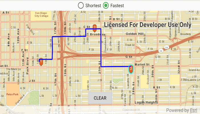
Tap once near a road to add a stop to the map. A number graphic will show its order in the route. After adding at least 2 stops, a route will display. Choose "Fastest" or "Shortest" from the switch at the top of the screen to control how the route is optimized. Tap stops to select them, then use a double-touch drag gesture to move them. The route will update on-the-fly while moving stops. The green box marks the boundary of the routable area provided by the offline data.
How it works
- Create the map's
Basemapfrom a local tile package using aTileCacheandArcGISTiledLayer. - Create a
RouteTaskwith an offline locator geodatabase. - Get the
RouteParametersusingrouteTask.createDefaultParameters(). - Create
Stops and add them to the route task's parameters. - Solve the
RouteusingrouteTask.solveRouteAsync(routeParameters). - Create a graphic with the route's geometry and a
SimpleLineSymboland display it on anotherGraphicsOverlay.
Offline data
- Download the data from ArcGIS Online.
- Extract the contents of the downloaded zip file to disk.
- Open your command prompt and navigate to the folder where you extracted the contents of the data from step 1.
- Execute the following commands:
adb push streetmap_SD.tpkx /Android/data/com.esri.arcgisruntime.sample.offlinerouting/files/san_diego/streetmap_SD.tpkx
adb push sandiego.geodatabase /Android/data/com.esri.arcgisruntime.sample.offlinerouting/files/san_diego/sandiego.geodatabase
| Link | Local Location |
|---|---|
| San Diego streetmap TPKX | /Android/data/com.esri.arcgisruntime.sample.offlinerouting/files/streetmap_SD.tpkx |
| San Diego Geodatabase | /Android/data/com.esri.arcgisruntime.sample.offlinerouting/files/sandiego.geodatabase |
About the data
This sample uses a pre-packaged sample dataset consisting of a geodatabase with a San Diego road network and a tile package with a streets basemap.
Relevant API
- RouteParameters
- RouteResult
- RouteTask
- Stop
- TravelMode
Tags
connectivity, disconnected, fastest, locator, navigation, network analysis, offline, routing, shortest, turn-by-turn
Sample Code
/*
* Copyright 2020 Esri
*
* Licensed under the Apache License, Version 2.0 (the "License");
* you may not use this file except in compliance with the License.
* You may obtain a copy of the License at
*
* http://www.apache.org/licenses/LICENSE-2.0
*
* Unless required by applicable law or agreed to in writing, software
* distributed under the License is distributed on an "AS IS" BASIS,
* WITHOUT WARRANTIES OR CONDITIONS OF ANY KIND, either express or implied.
* See the License for the specific language governing permissions and
* limitations under the License.
*
*/
package com.esri.arcgisruntime.sample.offlinerouting
import android.graphics.drawable.BitmapDrawable
import android.os.Bundle
import android.util.Log
import android.view.MotionEvent
import android.widget.Button
import android.widget.RadioGroup
import android.widget.Toast
import androidx.appcompat.app.AppCompatActivity
import androidx.core.content.ContextCompat
import com.esri.arcgisruntime.data.TileCache
import com.esri.arcgisruntime.geometry.Envelope
import com.esri.arcgisruntime.geometry.Point
import com.esri.arcgisruntime.geometry.SpatialReferences
import com.esri.arcgisruntime.layers.ArcGISTiledLayer
import com.esri.arcgisruntime.loadable.LoadStatus
import com.esri.arcgisruntime.mapping.ArcGISMap
import com.esri.arcgisruntime.mapping.Basemap
import com.esri.arcgisruntime.mapping.view.DefaultMapViewOnTouchListener
import com.esri.arcgisruntime.mapping.view.Graphic
import com.esri.arcgisruntime.mapping.view.GraphicsOverlay
import com.esri.arcgisruntime.mapping.view.MapView
import com.esri.arcgisruntime.symbology.CompositeSymbol
import com.esri.arcgisruntime.symbology.PictureMarkerSymbol
import com.esri.arcgisruntime.symbology.SimpleLineSymbol
import com.esri.arcgisruntime.symbology.TextSymbol
import com.esri.arcgisruntime.tasks.networkanalysis.RouteParameters
import com.esri.arcgisruntime.tasks.networkanalysis.RouteTask
import com.esri.arcgisruntime.sample.offlinerouting.databinding.ActivityMainBinding
import com.esri.arcgisruntime.tasks.networkanalysis.Stop
import kotlin.math.roundToInt
class MainActivity : AppCompatActivity() {
private val stopsOverlay: GraphicsOverlay by lazy { GraphicsOverlay() }
private val routeOverlay: GraphicsOverlay by lazy { GraphicsOverlay() }
private var routeParameters: RouteParameters? = null
private val routeTask: RouteTask by lazy {
RouteTask(
this,
getExternalFilesDir(null)?.path + getString(R.string.geodatabase_path),
"Streets_ND"
)
}
private val TAG: String = MainActivity::class.java.simpleName
private val activityMainBinding by lazy {
ActivityMainBinding.inflate(layoutInflater)
}
private val mapView: MapView by lazy {
activityMainBinding.mapView
}
private val clearButton: Button by lazy {
activityMainBinding.clearButton
}
private val modeSwitch: RadioGroup by lazy {
activityMainBinding.modeSwitch
}
override fun onCreate(savedInstanceState: Bundle?) {
super.onCreate(savedInstanceState)
setContentView(activityMainBinding.root)
// create a tile cache from the tpkx
val tileCache = TileCache(getExternalFilesDir(null)?.path + getString(R.string.tpkx_path))
val tiledLayer = ArcGISTiledLayer(tileCache)
// make a basemap with the tiled layer and add it to the mapview as an ArcGISMap
mapView.map = ArcGISMap(Basemap(tiledLayer))
// add the graphics overlays to the map view
mapView.graphicsOverlays.addAll(listOf(stopsOverlay, routeOverlay))
// load the route task
routeTask.loadAsync()
routeTask.addDoneLoadingListener {
if (routeTask.loadStatus == LoadStatus.LOADED) {
try {
// create route parameters
routeParameters = routeTask.createDefaultParametersAsync().get()
} catch (e: Exception) {
val error = "Error getting default route parameters. ${e.message}"
Log.e(TAG, error)
Toast.makeText(this, error, Toast.LENGTH_LONG).show()
}
} else {
val error = "Error loading route task: ${routeTask.loadError.message}"
Log.e(TAG, error)
Toast.makeText(this, error, Toast.LENGTH_LONG).show()
}
}
// set up travel mode switch
modeSwitch.setOnCheckedChangeListener { _, isChecked ->
routeParameters?.travelMode = when (isChecked) {
R.id.fastest_button -> routeTask.routeTaskInfo.travelModes[0]
R.id.shortest_button -> routeTask.routeTaskInfo.travelModes[1]
else -> routeTask.routeTaskInfo.travelModes[0]
}
Toast.makeText(
this,
"${routeParameters?.travelMode?.name} route selected.",
Toast.LENGTH_SHORT
).show()
updateRoute()
}
// make a clear button to reset the stops and routes
clearButton.setOnClickListener {
stopsOverlay.graphics.clear()
routeOverlay.graphics.clear()
}
// move the clear button above the attribution bar
mapView.addAttributionViewLayoutChangeListener { v, _, _, _, _, _, oldTop, _, oldBottom ->
val heightChanged = v.height - (oldBottom - oldTop)
clearButton.y += -heightChanged
}
// add a graphics overlay to show the boundary
GraphicsOverlay().let {
val envelope = Envelope(
Point(-13045352.223196, 3864910.900750, 0.0, SpatialReferences.getWebMercator()),
Point(-13024588.857198, 3838880.505604, 0.0, SpatialReferences.getWebMercator())
)
val boundarySymbol =
SimpleLineSymbol(SimpleLineSymbol.Style.DASH, 0xFF00FF00.toInt(), 5f)
it.graphics.add(Graphic(envelope, boundarySymbol))
mapView.graphicsOverlays.add(it)
}
// set up the touch listeners on the map view
createMapGestures()
}
/**
* Sets up the onTouchListener for the mapView.
* For single taps, graphics will be selected.
* For double touch drags, graphics will be moved.
* */
private fun createMapGestures() {
mapView.onTouchListener = object : DefaultMapViewOnTouchListener(this, mapView) {
override fun onSingleTapConfirmed(motionEvent: MotionEvent): Boolean {
val screenPoint = android.graphics.Point(
motionEvent.x.roundToInt(),
motionEvent.y.roundToInt()
)
addOrSelectGraphic(screenPoint)
return true
}
override fun onDoubleTouchDrag(motionEvent: MotionEvent): Boolean {
val screenPoint = android.graphics.Point(
motionEvent.x.roundToInt(),
motionEvent.y.roundToInt()
)
// move the selected graphic to the new location
if (stopsOverlay.selectedGraphics.isNotEmpty()) {
stopsOverlay.selectedGraphics[0]?.geometry =
mapView.screenToLocation(screenPoint)
updateRoute()
}
// ignore default double touch drag gesture
return true
}
// ignore default double tap gesture
override fun onDoubleTap(e: MotionEvent?): Boolean {
return true
}
}
}
/**
* Updates the calculated route by calling routeTask.solveRouteAsync().
* Creates a graphic to display the route.
* */
private fun updateRoute() {
// get a list of stops from the graphics currently on the graphics overlay.
val stops = stopsOverlay.graphics.map {
Stop(it.geometry as Point)
}
// do not calculate a route if there is only one stop
if (stops.size <= 1) return
routeParameters?.setStops(stops)
// solve the route
val results = routeTask.solveRouteAsync(routeParameters)
results.addDoneListener {
try {
val result = results.get()
val route = result.routes[0]
// create graphic for route
val graphic = Graphic(
route.routeGeometry, SimpleLineSymbol(
SimpleLineSymbol.Style.SOLID,
0xFF0000FF.toInt(), 3F
)
)
routeOverlay.graphics.clear()
routeOverlay.graphics.add(graphic)
} catch (e: Exception) {
val error = "No route solution. ${e.message}"
Log.e(TAG, error)
Toast.makeText(this, error, Toast.LENGTH_LONG).show()
routeOverlay.graphics.clear()
}
}
}
/**
* Selects a graphic if there is one at the provided tapped location or, if there is none, creates a new graphic.
*
* @param screenPoint a point in screen space where the user tapped
* */
private fun addOrSelectGraphic(screenPoint: android.graphics.Point) {
// identify the selected graphic
val results = mapView.identifyGraphicsOverlayAsync(stopsOverlay, screenPoint, 10.0, false)
results.addDoneListener {
try {
val graphics = results.get().graphics
// unselect everything
if (stopsOverlay.selectedGraphics.isNotEmpty()) {
stopsOverlay.unselectGraphics(stopsOverlay.selectedGraphics)
}
// if the user tapped on something, select it
if (graphics.isNotEmpty()) {
val firstGraphic = graphics[0]
firstGraphic.isSelected = true
} else { // there is no graphic at this location
// make a new graphic at the tapped location
val locationPoint = mapView.screenToLocation(screenPoint)
createStopSymbol(stopsOverlay.graphics.size + 1, locationPoint)
}
} catch (e: Exception) {
val error = "Error identifying graphic: ${e.stackTrace}"
Log.e(TAG, error)
Toast.makeText(this, error, Toast.LENGTH_LONG).show()
}
}
}
/**
* Creates a composite symbol to represent a numbered stop.
*
* @param stopNumber the ordinal number of this stop
* @param locationPoint the point in map space where the symbol should be placed
*/
private fun createStopSymbol(stopNumber: Int, locationPoint: Point) {
try {
// create a new picture marker symbol and load it
val pictureMarkerSymbol = PictureMarkerSymbol.createAsync(
ContextCompat.getDrawable(
this,
R.drawable.pin_symbol
) as BitmapDrawable
).get()
// create a text symbol with the stop number
val textSymbol = TextSymbol(
12f,
stopNumber.toString(),
0xFFFFFFFF.toInt(),
TextSymbol.HorizontalAlignment.CENTER,
TextSymbol.VerticalAlignment.BOTTOM
)
textSymbol.offsetY = -4f
// create a composite symbol and add the picture marker symbol and text symbol
val compositeSymbol = CompositeSymbol()
compositeSymbol.symbols.addAll(listOf(pictureMarkerSymbol, textSymbol))
// create a graphic to add to the overlay and update the route
val graphic = Graphic(locationPoint, compositeSymbol)
stopsOverlay.graphics.add(graphic)
updateRoute()
} catch (e: Exception) {
Log.e(TAG, "Failed to create composite symbol: ${e.stackTrace}")
}
}
override fun onPause() {
mapView.pause()
super.onPause()
}
override fun onResume() {
super.onResume()
mapView.resume()
}
override fun onDestroy() {
mapView.dispose()
super.onDestroy()
}
}