The following functions allow you to create, compare, measure, and analyze geometries. The spatial reference of all geometries either input or created by any of these functions must match the spatial reference of the profile's context, which controls the execution of the expression.
Angle
This function has 2 signatures:
Angle(pointA, pointB) -> Number
Function bundle: Geometry
Returns the arithmetic angle of a line between two points in degrees (0 - 360). The angle is measured in a counter-clockwise direction relative to east. For example, an angle of 90 degrees points due north.
Only the x-y plane is considered for the measurement. Any z-coordinates are ignored. Point features can be used instead of any or both Point geometries. If the points are identical, then an angle of 0 degrees is returned.
Parameters
- pointA: Point | Feature - The first Point or Feature used to calculate the angle.
- pointB: Point | Feature - The second Point or Feature used to calculate the angle.
Return value: Number

Example
Returns the angle from a Point to a Feature, in degrees
var pointA = Point({ "x":976259, "y":8066511, "spatialReference": { "wkid": 3857 } });
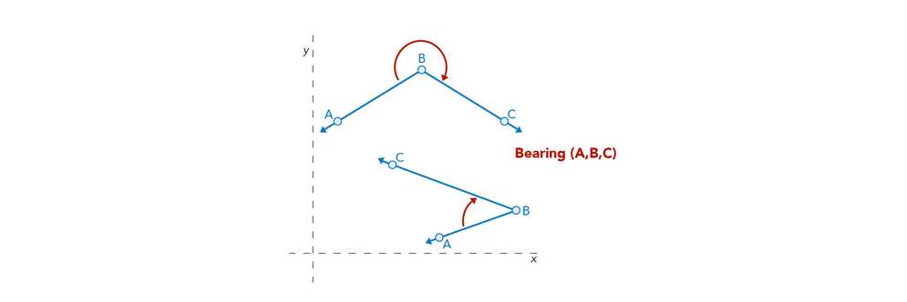
Angle(pointA, $feature)Angle(pointA, pointB, pointC) -> Number
Function bundle: Geometry
Returns the arithmetic angle of a line between three points in degrees (0 - 360). The angle is measured around point in a counter-clockwise direction, from point to point.
Only the x-y plane is considered for the measurement. Any z-coordinates are ignored. Point features can be used instead of either or all Point geometries. If the points are identical, then an angle of 0 or 180 degrees is returned (depending internal arithmetic).
Parameters
- pointA: Point | Feature - The first Point or Feature used to calculate the angle.
- pointB: Point | Feature - The second Point or Feature used to calculate the angle.
- pointC: Point | Feature - The third Point or Feature used to calculate the angle.
Return value: Number

Example
Returns the angle between two points around the feature, in degrees
var pointA = Point({ "x":976259, "y":8066511, "spatialReference": { "wkid": 3857 } });
var pointC = Point({ "x":308654, "y":9005421, "spatialReference": { "wkid": 3857 } });
Angle(pointA, $feature, pointC)Area
Area(polygon, unit?) -> Number
Function bundle: Geometry
Returns the area of the input geometry or Feature in the given units. This is a planar measurement using Cartesian mathematics.
Feature geometries in the visualization and labeling profiles are generalized according to the view's scale resolution to improve drawing performance. Therefore, using a feature's geometry (i.e. $feature) as input to any geometry function in these contexts will return different results at each scale level. Other profiles, such as popup, provide the full resolution geometry.
Parameters
- polygon: Polygon | Feature | Array<Point> - The Polygon or Feature for which to calculate the planar area.
- unit (Optional): Text | Number - Measurement unit of the return value.
Possible values:acres|square-feet|hectares|square-kilometers|square-miles|square-nautical-miles|square-meters|square-yards
Return value: Number
Example
Returns the area of the feature in square meters
Area($feature, 'square-meters')AreaGeodetic
AreaGeodetic(polygon, unit?) -> Number
Function bundle: Geometry
Returns the geodetic area of the input geometry or Feature in the given units. This is more reliable measurement of area than Area() because it takes into account the Earth's curvature. Support is limited to geometries with a Web Mercator (wkid 3857) or a WGS 84 (wkid 4326) spatial reference.
Feature geometries in the visualization and labeling profiles are generalized according to the view's scale resolution to improve drawing performance. Therefore, using a feature's geometry (i.e. $feature) as input to any geometry function in these contexts will return different results at each scale level. Other profiles, such as popup, provide the full resolution geometry.
Parameters
- polygon: Polygon | Feature | Array<Point> - The Polygon or Feature for which to calculate the geodetic area.
- unit (Optional): Text | Number - Measurement unit of the return value.
Possible values:acres|square-feet|hectares|square-kilometers|square-miles|square-nautical-miles|square-meters|square-yards
Return value: Number
Example
Returns the geodetic area of the feature in square meters
AreaGeodetic($feature, 'square-meters')Bearing
This function has 2 signatures:
Bearing(pointA, pointB) -> Number
Function bundle: Geometry
Returns the geographic angle of a line between two points in degrees (0 - 360). The bearing is measured in a clockwise direction relative to north. For example, a bearing of 225 degrees represents a southwest orientation.
Only the x-y plane is considered for the measurement. Any z-coordinates are ignored. Point features can be used instead of either or both Point geometries. If the points are identical, then an angle of 0 is returned.
Parameters
- pointA: Point | Feature - The first point used to calculate the bearing.
- pointB: Point | Feature - The second point used to calculate the bearing.
Return value: Number

Example
Returns the bearing from a point to the feature, in degrees
var pointA = Point({ "x":976259, "y":8066511, "spatialReference": { "wkid": 3857 } });
Bearing(pointA,$feature)Bearing(pointA, pointB, pointC) -> Number
Function bundle: Geometry
Returns the geographic angle of a line between three points in degrees (0 - 360). The bearing is measured around point in a clockwise direction, from point to point.
Only the x-y plane is considered for the measurement. Any z-coordinates are ignored. Point features can be used instead of any or all Point geometries. If the points are identical, then an angle of 0 or 180 degrees is returned (depending internal arithmetic).
Parameters
- pointA: Point | Feature - The first point used to calculate the bearing.
- pointB: Point | Feature - The second point used to calculate the bearing.
- pointC: Point | Feature - The third point used to calculate the bearing.
Return value: Number
Example
Returns the bearing between two points around the feature, in degrees
var pointA = Point({ "x":976259, "y":8066511, "spatialReference": { "wkid": 3857 } });
var pointC = Point({ "x":308654, "y":9005421, "spatialReference": { "wkid": 3857 } });
Bearing(pointA,$feature,pointC)Buffer
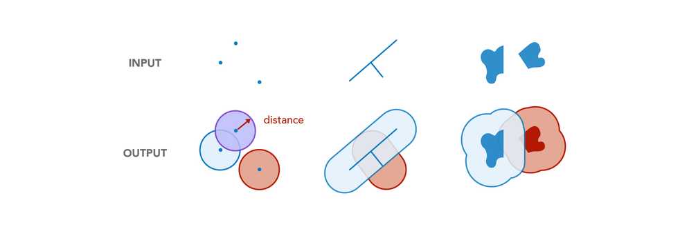
Buffer(inputGeometry, distance, unit?) -> Polygon
Function bundle: Geometry
Returns the planar (or Euclidean) buffer at a specified distance around the input geometry. This is a planar measurement using Cartesian mathematics.
Feature geometries in the visualization and labeling profiles are generalized according to the view's scale resolution to improve drawing performance. Therefore, using a feature's geometry (i.e. $feature) as input to any geometry function in these contexts will return different results at each scale level. Other profiles, such as popup, provide the full resolution geometry.
Parameters
- inputGeometry: Geometry | Feature - The geometry to buffer.
- distance: Number - The distance to buffer from the geometry.
- unit (Optional): Text | Number - Measurement unit of the buffer
distance. For the visualization, labeling, and popup profiles, the default unit is the map's spatial reference. In other profiles, like field calculation, the default is based on the spatial reference of the data.
Possible values:feet|kilometers|miles|nautical-miles|meters|yards
Return value: Polygon
Example
Returns a polygon representing a 1/2-mile buffer around the input geometry
Buffer($feature, 0.5, 'miles')BufferGeodetic
BufferGeodetic(inputGeometry, distance, unit?) -> Polygon
Function bundle: Geometry
Returns the geodetic buffer at a specified distance around the input geometry. This is a geodetic measurement, which calculates distances on an ellipsoid. Support is limited to geometries with a Web Mercator (wkid 3857) or a WGS 84 (wkid 4326) spatial reference.
Feature geometries in the visualization and labeling profiles are generalized according to the view's scale resolution to improve drawing performance. Therefore, using a feature's geometry (i.e. $feature) as input to any geometry function in these contexts will return different results at each scale level. Other profiles, such as popup, provide the full resolution geometry.
Parameters
- inputGeometry: Geometry | Feature - The geometry to buffer.
- distance: Number - The distance to buffer from the geometry.
- unit (Optional): Text | Number - Measurement unit of the buffer
distance. For the visualization, labeling, and popup profiles, the default unit is the map's spatial reference. In other profiles, like field calculation, the default is based on the spatial reference of the data.
Possible values:feet|kilometers|miles|nautical-miles|meters|yards
Return value: Polygon
Example
Returns a polygon representing a 1/2-mile buffer around the input geometry
BufferGeodetic($feature, 0.5, 'miles')Centroid
Centroid(polygon) -> Point
Function bundle: Geometry
Returns the centroid of the input geometry.
Parameter
Return value: Point
Examples
Returns the centroid of the given polygon
Centroid($feature)Returns the centroid of the given polygon ring
var ringPoints = Geometry($feature).rings[0];
Centroid(ringPoints);Clip
Clip(inputGeometry, envelope) -> Geometry
Function bundle: Geometry
Calculates the clipped geometry from a target geometry by an envelope.
Feature geometries in the visualization and labeling profiles are generalized according to the view's scale resolution to improve drawing performance. Therefore, using a feature's geometry (i.e. $feature) as input to any geometry function in these contexts will return different results at each scale level. Other profiles, such as popup, provide the full resolution geometry.
Parameters
- inputGeometry: Geometry | Feature - The geometry to be clipped.
- envelope: Extent - The envelope used to clip the
geometry.
Return value: Geometry
Example
Returns the area of the clipped geometry
var envelope = Extent({ ... });
Area(Clip($feature, envelope), 'square-miles');Contains
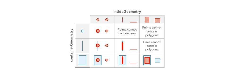
This function has 2 signatures:
- Contains(containerGeometry, insideGeometry) -> Boolean
- Contains(containerGeometry, insideFeatures) -> FeatureSet
Contains(containerGeometry, insideGeometry) -> Boolean
Function bundle: Geometry
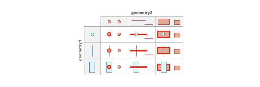
Indicates if one geometry contains another geometry. In the graphic below, the red highlight indicates the scenarios where the function will return true.
Be aware that using $feature as input to this function will yield results only as precise as the view's scale resolution. Therefore values returned from expressions using this function may change after zooming between scales.
Parameters
- containerGeometry: Geometry | Feature - The geometry that is tested for the 'contains' relationship to
inside. Think of this geometry as the potential 'container' of theGeometry inside.Geometry - insideGeometry: Geometry | Feature - The geometry that is tested for the 'within' relationship to the
container.Geometry
Return value: Boolean
Example
Returns true if the feature is contained within the given polygon
var container = Polygon({ ... });
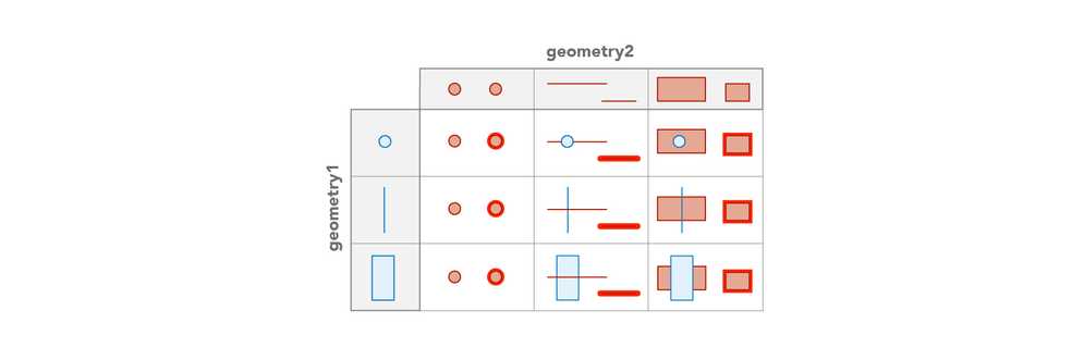
Contains(containerGeometry, $feature);Contains(containerGeometry, insideFeatures) -> FeatureSet
Function bundle: Geometry
Returns features from a FeatureSet that are contained within the input geometry. In the graphic below, the red highlight illustrates the spatial relationships where the function will return features.
Be aware that using $feature as input to this function will yield results only as precise as the view's scale resolution. Therefore values returned from expressions using this function may change after zooming between scales.
Parameters
- containerGeometry: Geometry | Feature - The geometry that is tested for the 'contains' relationship to
inside. Think of this geometry as the potential 'container' of theFeatures inside.Features - insideFeatures: FeatureSet - The FeatureSet that is tested for the 'within' relationship to the
container.Geometry
Return value: FeatureSet
Example
Returns the number of features that are within the given polygon
var parcels = FeatureSetByName($map, 'parcels')
var projectArea = $feature;
Count(Contains(projectArea, parcels));ConvertDirection
ConvertDirection(input, inputSpec, outputSpec) -> Array<Number | Text> | Number | Text
Function bundle: Geometry
Angles can have several interpretations and can be represented as a number, a text, or a well formed array. This function takes one input representation and converts it to another.
The input value is described by a dictionary that specified the type of angle and the type of direction. Examples:
| input | angle type | direction type |
|---|---|---|
| 12.34 | dms, degrees, radians, gradians | north, south, polar |
| 12.3456 | dms, degrees, radians, gradians | north, south, polar |
| [12,34,56] | dms | north, south, polar |
| ['N',12.34,'W'] | dms, degrees, radians, gradians | quadrant |
| ['N',12,34,56,'W'] | dms | quadrant |
| '12.34' | dms, degrees, radians, gradians | north, south, polar |
| '12 34 56' | dms | north, south, polar |
| 'N 12.34 W' | dms, degrees, radians, gradians | quadrant |
| 'N 12 34 56 W' | dms | quadrant |
If the angle and direction are not appropriate for the input, then the conversion will fail.
The desired output value is as well described by a dictionary that specidies output type, angle type, direction type, and an optional format for text ouput.
If the output type is value:
- an array will be returned for angle type
dmsor for direction typequadrant - a number will be returned for all the other cases
If the output type is text, then default padding and delimeters will be used unless the optionalformat property is provided.
format controls order, spacing, padding, and delimeters in the output text.
Strings of format specifier characters before a decimal point indicate minimum padding (e.g. DDD -> 000).
Strings of format characters after a decimal point indicate precision (e.g. D.DD -> 0.00).
Supported format characters:
| Code | Meaning |
|---|---|
D | Decimal Degrees |
R | Radians |
G | Gradians |
d | DMS Degrees |
m | DMS Minutes |
s | DMS Seconds |
P | Long Meridian (e.g. North vs. South) |
p | Short Meridian (e.g. N vs. S) |
B | Long direction (e.g. East vs. West) |
b | Short direction (e.g. E vs. W) |
[ ] | Escape characters |
For dms formatting, if the s is not used then m will round to the nearest minute. Similarly, if m is not used then d will round.
Parameters
-
input: Array<Number | Text> | Number | Text - A raw representation of the bearing. The type of
inputand the values of theinputdictate how the input is parsed.Spec -
inputSpec: Dictionary - Contains information about how to interpret input.
-
outputSpec: Dictionary - Contains information about how to format the output.
- outputType: Text - Controls output type. Supported Values:
value,text - angleType: Text - Describes the output angle unit. Supported Values:
DEGREES,DMS,RADIANS,GONS,GRADIANS - directionType: Text - Describes the output bearing's meridian and direction. Supported Values:
NORTH,SOUTH,POLAR,QUADRANT - format (Optional): Text - Controls text formatting. Only applicable if
outputisType text.
- outputType: Text - Controls output type. Supported Values:
Return value: Array<Number | Text> | Number | Text
Examples
Examples where the output is value.
ConvertDirection( 30, {directionType:'North', angleType: 'Degrees'}, {directionType:'Quadrant', angleType: 'DMS', outputType: 'value'})
// returns ['N', 30, 0, 0, 'E']
ConvertDirection( 25.99, {directionType:'North', angleType : 'Gradians'}, {directionType:'North', outputType: 'value', angleType : 'Gradians'})
// returns 25.99
ConvertDirection( 1, {directionType:'North', angleType: 'DEGREES'}, {directionType: 'Quadrant', angleType: 'Degrees', outputType: 'value'})
// returns ['N',1,'E']
ConvertDirection( 0.9, {directionType: 'North', angleType: 'degrees'}, {directionType:'North', angleType: 'gradians', outputType: 'value'})
// returns 1.0
ConvertDirection( 180.0, {directionType:'North', angleType: 'degrees'}, {directionType:'North', angleType: 'radians', outputType : 'value'})
// returns PIExamples where output is text.
ConvertDirection( 25.34, {directionType: 'North', angleType: 'DEGREES'}, {directionType:'North', outputType: 'text', format: 'DDDD.D'})
// returns '0025.3'
ConvertDirection( 25.34, {directionType: 'North', angleType: 'DEGREES'}, {directionType:'North', outputType: 'text', format: 'R'})
// returns '0'
ConvertDirection( 25.34, {directionType: 'North', angleType: 'DEGREES'}, {directionType:'North', outputType: 'text', format: '[DD.DD]'})
// returns 'DD.DD'
ConvertDirection( 25.34, {directionType:'North', angleType: 'DEGREES'}, {directionType:'quadrant', outputType: 'text', format: 'P B'})
// returns 'North East'
ConvertDirection( [001,01,59.99], {directionType:'North', angleType: 'DMS'}, {directionType:'North', angleType: 'DMS', outputType: 'text', format: 'dddA mm[B] ssC'})
// returns '001A 02B 00C'ConvexHull
ConvexHull(inputGeometry) -> Geometry
Function bundle: Geometry
Calculates the convex hull of a geometry. A convex hull is the smallest convex polygon that encloses a geometry. The hull is typically a polygon but can also be a polyline or a point in degenerate cases.
Be aware that using $feature as input to this function will yield results only as precise as the view's scale resolution. Therefore values returned from expressions using this function may change after zooming between scales.
Parameter
Return value: Geometry
Examples
Returns the number of vertices in the convex hull geometry of the current feature's geometry
Count(ConvexHull(Geometry($feature)).Rings[0])Returns the convex hull of a geometry which has a concave region (which the convex hull will ignore)
var pacman_like_shape = Polygon({
"rings": [[[1, 2], [2, 0], [1, -2], [-1, -2], [-2, -1], [-1, -1.5], [0, -1.5], [-2, 1], [-1, 2]]],
"spatialReference": { "wkid": 3857 }
});
return ConvexHull(pacman_like_shape).rings[0];
// Returns the geometry [[1,2],[2,0],[1,-2],[-1,-2],[-2,-1],[-2,1],[-1,2],[1,2]]Crosses
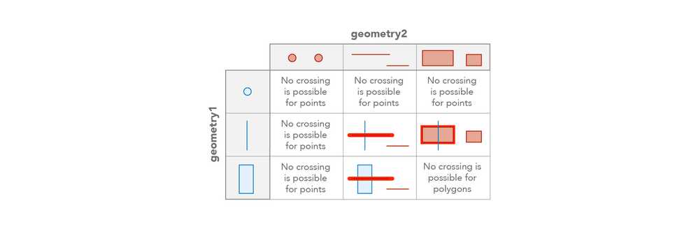
Crosses(geometry1, geometry2) -> Boolean
Function bundle: Geometry
Indicates if one geometry crosses another geometry. In the graphic below, the red highlight indicates the scenarios where the function will return true.
Feature geometries in the visualization and labeling profiles are generalized according to the view's scale resolution to improve drawing performance. Therefore, using a feature's geometry (i.e. $feature) as input to any geometry function in these contexts will return different results at each scale level. Other profiles, such as popup, provide the full resolution geometry.
Parameters
- geometry1: Geometry | Feature - The geometry to cross.
- geometry2: Geometry | Feature - The geometry being crossed.
Return value: Boolean
Example
Returns true if the feature crosses the given polygon
var geom2 = Polygon({ ... });
Crosses($feature, geom2);Cut
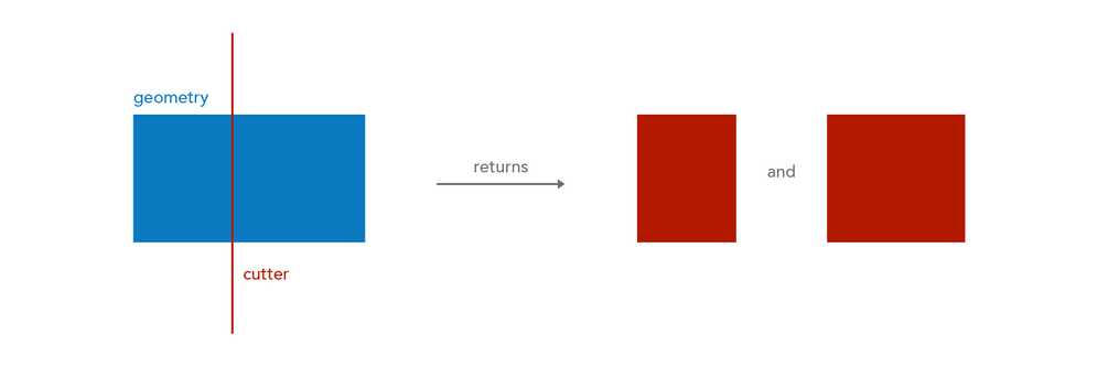
Cut(polylineOrPolygon, cutter) -> Array<Geometry>
Function bundle: Geometry
Splits the input Polyline or Polygon where it crosses a cutting Polyline. For Polylines, all resulting left cuts are grouped together in the first Geometry. Right cuts and coincident cuts are grouped in the second Geometry. Each undefined cut, along with any uncut parts, are output as separate Polylines.
For Polygons, all resulting left cuts are grouped in the first Polygon, all right cuts are grouped in the second Polygon, and each undefined cut, along with any left-over parts after cutting, are output as a separate Polygon. If no cuts are returned then the array will be empty. An undefined cut will only be produced if a left cut or right cut was produced and there was a part left over after cutting, or a cut is bounded to the left and right of the cutter.
Feature geometries in the visualization and labeling profiles are generalized according to the view's scale resolution to improve drawing performance. Therefore, using a feature's geometry (i.e. $feature) as input to any geometry function in these contexts will return different results at each scale level. Other profiles, such as popup, provide the full resolution geometry.
Parameters
- polylineOrPolygon: Polyline | Polygon | Feature - The geometry to cut.
- cutter: Polyline | Feature - The Polyline used to cut the
geometry.
Example
Cuts the feature's geometry with the given polyline
var cutter = Polyline({ ... });
Cut($feature, cutter));DefaultValue
This function has 2 signatures:
- DefaultValue(container, key, defaultValue) -> Any
- DefaultValue(container, keys, defaultValue) -> Any
DefaultValue(container, key, defaultValue) -> Any
Function bundle: Core
Returns a specified default value if a key in a geometry does not exist or the value at the specified key is null or an empty text value.
Parameters
- container: Geometry - The input geometry to check.
- key: Text - The key to check.
- defaultValue: Any - This value is returned if the key does not exist or the value at the specified key is
nullor an empty text value.
Return value: Any
Returns the value at the specified key if defined. Otherwise, returns the value specified in default.
Examples
Point that has a z-value
DefaultValue(Geometry($feature), "z", 1000)
// Geometry($feature).hasZ is true
// returns the value of Geometry($feature).zPoint that does not have a z-value
DefaultValue(Geometry($feature), "z", 1000)
// Geometry($feature).hasZ is false
// returns 1000DefaultValue(container, keys, defaultValue) -> Any
Function bundle: Core
Returns a specified default value if at least one of the keys in a geometry's nested properties does not exist or the value at the specified key is null or an empty text value.
Parameters
- container: Geometry - The input geometry to check.
- keys: Array<Number | Text> - An array of the keys or indexes to check in each level of the container's structure.
- defaultValue: Any - This value is returned if at least one of the keys or indices does not exist or the value at the specified key is
nullor an empty text value.
Return value: Any
Returns the value at the specified key or index if defined. Otherwise, returns the value specified in default.
Examples
Ring, coordinate, and x value all exist and have a value
// polygon with one ring
var shape = Polygon({
rings: [[
Point({ x: -97.06138, y: 32.837, z: 100, hasZ: true, spatialReference: { wkid: 102100 } }),
Point({ x: -97.06133, y: 32.836, z: 50, hasZ: true, spatialReference: { wkid: 102100 } }),
Point({ x: -97.06124, y: 32.834, z: 20, hasZ: true, spatialReference: { wkid: 102100 } }),
Point({ x: -97.06127, y: 32.832, z: 0, hasZ: true, spatialReference: { wkid: 102100 } })
]],
hasZ: true,
spatialReference: { wkid: 102100 }
});
return DefaultValue(shape, ["rings",0,0,"z"], 1000)
// returns 100Ring does not exist
// polygon with one ring
var shape = Polygon({
rings: [[
Point({ x: -97.06138, y: 32.837, z: 100, hasZ: true, spatialReference: { wkid: 102100 } }),
Point({ x: -97.06133, y: 32.836, z: 50, hasZ: true, spatialReference: { wkid: 102100 } }),
Point({ x: -97.06124, y: 32.834, z: 20, hasZ: true, spatialReference: { wkid: 102100 } }),
Point({ x: -97.06127, y: 32.832, z: 0, hasZ: true, spatialReference: { wkid: 102100 } })
]],
hasZ: true,
spatialReference: { wkid: 102100 }
});
return DefaultValue(shape, ["rings",2,0,"z"], 1000)
// returns 1000Ring and coordinate exist, but m-value does not exist
// polygon with one ring
var shape = Polygon({
rings: [[
Point({ x: -97.06138, y: 32.837, z: 100, hasZ: true, spatialReference: { wkid: 102100 } }),
Point({ x: -97.06133, y: 32.836, z: 50, hasZ: true, spatialReference: { wkid: 102100 } }),
Point({ x: -97.06124, y: 32.834, z: 20, hasZ: true, spatialReference: { wkid: 102100 } }),
Point({ x: -97.06127, y: 32.832, z: 0, hasZ: true, spatialReference: { wkid: 102100 } })
]],
hasZ: true,
spatialReference: { wkid: 102100 }
});
return DefaultValue(shape, ["rings",0,0,"m"], 100)
// returns 100Densify
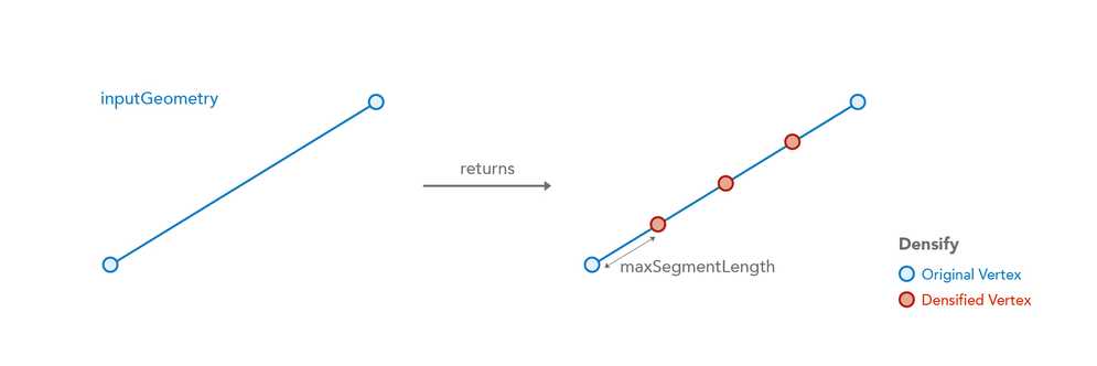
Densify(inputGeometry, maxSegmentLength, unit?) -> Geometry
Function bundle: Geometry
Densifies geometries by inserting vertices to create segments no longer than the specified interval.
Feature geometries in the visualization and labeling profiles are generalized according to the view's scale resolution to improve drawing performance. Therefore, using a feature's geometry (i.e. $feature) as input to any geometry function in these contexts will return different results at each scale level. Other profiles, such as popup, provide the full resolution geometry.
Parameters
- inputGeometry: Geometry | Feature - The input geometry to be densified.
- maxSegmentLength: Number - The maximum segment length allowed. Must be a positive value.
- unit (Optional): Text | Number - Measurement unit for maxSegmentLength. Defaults to the units of the input geometry. For the visualization, labeling, and popup profiles, the default unit is the map's spatial reference. In other profiles, like field calculation, the default is based on the spatial reference of the data.
Possible values:feet|kilometers|miles|nautical-miles|meters|yards
Return value: Geometry
Example
Returns the densified geometry with a maximum segment length of 10 m
var maxLength = 10;
Densify($feature, maxLength, 'meters');DensifyGeodetic
DensifyGeodetic(inputGeometry, maxSegmentLength, unit?) -> Geometry
Function bundle: Geometry
Creates a geodesic between each of the input geometry's vertices and densifies the output geometry with additional vertices to create segments no longer than the specified interval.
Be aware that using $feature as input to this function will yield results only as precise as the view's scale resolution. Therefore values returned from expressions using this function may change after zooming between scales.
Parameters
- inputGeometry: Geometry | Feature - The input geometry to be densified.
- maxSegmentLength: Number - The maximum segment length allowed. Must be a positive value.
- unit (Optional): Text | Number - Measurement unit for maxSegmentLength. Defaults to the units of the input geometry. For the visualization, labeling, and popup profiles, the default unit is the map's spatial reference. In other profiles, like field calculation, the default is based on the spatial reference of the data.
Possible values:feet|kilometers|miles|nautical-miles|meters|yards
Return value: Geometry

Example
Returns the densified geometry with a maximum segment length of 10000
DensifyGeodetic($feature, 10000, 'meters');Difference
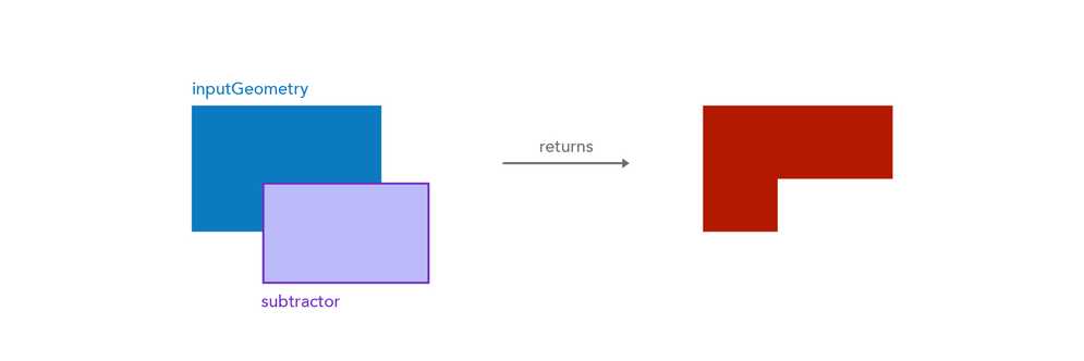
Difference(inputGeometry, subtractor) -> Geometry
Function bundle: Geometry
Performs the topological difference operation for the two geometries. The resultant geometry comes from input, not the subtractor. The dimension of subtractor has to be equal to or greater than that of input.
Feature geometries in the visualization and labeling profiles are generalized according to the view's scale resolution to improve drawing performance. Therefore, using a feature's geometry (i.e. $feature) as input to any geometry function in these contexts will return different results at each scale level. Other profiles, such as popup, provide the full resolution geometry.
Parameters
- inputGeometry: Geometry | Feature - The input geometry from which to subtract.
- subtractor: Geometry | Feature - The geometry to subtract from
geometry.
Return value: Geometry
Example
Subtracts the given polygon area from the feature.
var subtractor = Polygon({ ... });
Difference($feature, subtractor);Disjoint
Disjoint(geometry1, geometry2) -> Boolean
Function bundle: Geometry
Indicates if one geometry is disjoint (doesn't intersect in any way) with another geometry. In the table below, the red highlight indicates that the function would return true with the specified geometries.
Feature geometries in the visualization and labeling profiles are generalized according to the view's scale resolution to improve drawing performance. Therefore, using a feature's geometry (i.e. $feature) as input to any geometry function in these contexts will return different results at each scale level. Other profiles, such as popup, provide the full resolution geometry.
Parameters
- geometry1: Geometry | Feature - The base geometry that is tested for the 'disjoint' relationship to
geometry2. - geometry2: Geometry | Feature - The comparison geometry that is tested for the 'disjoint' relationship to
geometry1.
Return value: Boolean
Example
Returns true if the geometries don't intersect
var geom2 = Polygon({ ... });
Disjoint($feature, geom2);Distance
Distance(geometry1, geometry2, unit?) -> Number
Function bundle: Geometry
Returns the planar distance between two geometries in the given units. This is a planar measurement using Cartesian mathematics.
Feature geometries in the visualization and labeling profiles are generalized according to the view's scale resolution to improve drawing performance. Therefore, using a feature's geometry (i.e. $feature) as input to any geometry function in these contexts will return different results at each scale level. Other profiles, such as popup, provide the full resolution geometry.
Parameters
- geometry1: Geometry | Feature | Array<Point> - The geometry used to measure the distance from
geometry2. - geometry2: Geometry | Feature | Array<Point> - The geometry used to measure the distance from
geometry1. - unit (Optional): Text | Number - Measurement unit of the return value. For the visualization, labeling, and popup profiles, the default unit is the map's spatial reference. In other profiles, like field calculation, the default is based on the spatial reference of the data.
Possible values:feet|kilometers|miles|nautical-miles|meters|yards
Return value: Number
Example
Returns the distance between two geometries in meters
var geom2 = Point({ ... });
Distance($feature, geom2, 'meters')DistanceGeodetic
DistanceGeodetic(point1, point2, units?) -> Number
Function bundle: Geometry
Calculates the shortest distance between two points along a great circle. Applies only to points with a Geographic Coordinate System (GCS) or the Web Mercator spatial reference. If the input points have a Projected Coordinate System (other than Web Mercator), you should use the Distance() function.
Feature geometries in the visualization and labeling profiles are generalized according to the view's scale resolution to improve drawing performance. Therefore, using a feature's geometry (i.e. $feature) as input to any geometry function in these contexts will return different results at each scale level. Other profiles, such as popup, provide the full resolution geometry.
Parameters
- point1: Point | Feature - The point used to measure the distance from
point2. This point must have a GCS or Web Mercator spatial reference. - point2: Point | Feature - The point used to measure the distance from
point1. This point must have a GCS or Web Mercator spatial reference. - units (Optional): Text | Number - Measurement unit of the return value. For the visualization, labeling, and popup profiles, the default unit is the map's spatial reference. In other profiles, like field calculation, the default is based on the spatial reference of the data.
Possible values:feet|kilometers|miles|nautical-miles|meters|yards
Return value: Number
Additional resources
Example
Returns the distance from a bus in a stream layer to the central station in kilometers
var unionStation = Point({"x": -118.15, "y": 33.80, "spatialReference": { "wkid": 3857 }});
distanceGeodetic($feature, unionStation, 'kilometers');DistanceToCoordinate
DistanceToCoordinate(inputLine, inputDistance) -> Dictionary
Function bundle: Geometry
Returns a coordinate along an input line based on a given distance. All parts of the line are considered when attempting to find a coordinate at the given distance. The distance does not include gaps between paths (or parts) of the line. If the distance is not found along the input line, then the result will be null.
Feature geometries in the visualization and labeling profiles are generalized according to the view's scale resolution to improve drawing performance. Therefore, using a feature's geometry (i.e. $feature) as input to any geometry function in these contexts will return different results at each scale level. Other profiles, such as popup, provide the full resolution geometry.
Parameters
- inputLine: Polyline | Array<Point> | Feature - The line or path from which to find a coordinate. When using a Feature as input, the feature's geometry must be a polyline.
- inputDistance: Number - The distance used to find the coordinate along
inputfrom the start of the line. All parts of the line are considered when attempting to find a coordinate at the given distance. The distance does not include gaps between paths (or parts) of the line.Line
Return value: Dictionary
Returns a dictionary with the following properties. If the distance is not found along the input line, then the result will be null.
- coordinate: Point - The coordinates of a point along
inputbased on the given distance value.Line - distanceAlong: Number - The planar distance from the start of the
inputmeasured along the line to theLine coordinate. In polylines where paths do not connect, thedistancevalue does not include the distance of the gaps between the starting and ending vertices of the paths.Along - partId: Number - In the case of a polyline input, the index of the path to which the
coordinatebelongs. - segmentId: Number - The index (relative to the path) of the line segment to which the
coordinatebelongs. Ifcoordinaterepresents a vertex of the input line, thensegmentwill return the index of the previous vertex. IfI d coordinateis the first vertex ofinput, then the value ofLine segmentwill beI d 0.
Example
Returns the coordinate of the input polyline based on the given distance value
var result = DistanceToCoordinate($feature, 1038);
return result.coordinate;EnvelopeIntersects
EnvelopeIntersects(geometry1, geometry2) -> Boolean
Function bundle: Geometry
Indicates if the envelope (or extent) of one geometry intersects the envelope of another geometry. In the graphic below, the red highlight indicates the scenarios where the function will return true.
Feature geometries in the visualization and labeling profiles are generalized according to the view's scale resolution to improve drawing performance. Therefore, using a feature's geometry (i.e. $feature) as input to any geometry function in these contexts will return different results at each scale level. Other profiles, such as popup, provide the full resolution geometry.
Parameters
- geometry1: Geometry | Feature - The geometry that is tested for the intersects relationship to the other geometry.
- geometry2: Geometry | Feature - The geometry being intersected.
Return value: Boolean

Example
Returns true if the geometries intersect
var geom2 = Polygon({ ... });
EnvelopeIntersects($feature, geom2);Equals
Equals(geometry1, geometry2) -> Boolean
Function bundle: Geometry
Indicates if two geometries are equal, or geographically equivalent given the spatial reference and tolerance of the data. The two input geometries don't have to be clones to be considered equal.
Feature geometries in the visualization and labeling profiles are generalized according to the view's scale resolution to improve drawing performance. Therefore, using a feature's geometry (i.e. $feature) as input to any geometry function in these contexts will return different results at each scale level. Other profiles, such as popup, provide the full resolution geometry.
Parameters
- geometry1: Geometry | Feature - The first input geometry.
- geometry2: Geometry | Feature - The second input geometry.
Return value: Boolean
Example
Returns true if the geometries are equal
var geom2 = Point({ ... });
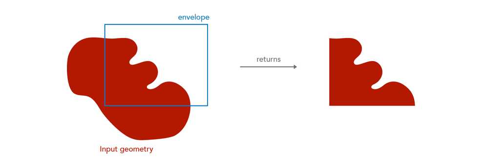
Equals($feature, geom2);Extent
This function has 3 signatures:
- Extent(geometryDefinition) -> Extent
- Extent(inputGeometry) -> Extent
- Extent(jsonDefinition) -> Extent
Extent(geometryDefinition) -> Extent
Function bundle: Geometry
Constructs an Extent object from a dictionary.
Parameter
-
geometryDefinition: Dictionary - The properties from which to construct the Extent geometry object.
-
xMax: Number - The upper bound, or largest possible x-coordinate of the geometry.
-
xMin: Number - The lower bound, or smallest possible x-coordinate of the geometry.
-
yMax: Number - The upper bound, or largest possible y-coordinate of the geometry.
-
yMin: Number - The lower bound, or smallest possible y-coordinate of the geometry.
-
mMax: Number - The upper bound, or largest possible m-value of the geometry. If setting this value, then you must set
hastoM true. -
mMin: Number - The lower bound, or smallest possible m-value of the geometry. If setting this value, then you must set
hastoM true. -
zMax: Number - The upper bound, or largest possible z-value of the geometry. If setting this value, then you must set
hastoZ true. -
zMin: Number - The lower bound, or smallest possible z-value of the geometry. If setting this value, then you must set
hastoZ true. -
hasM: Boolean - Indicates if the geometry has m-values.
-
hasZ: Boolean - Indicates if the geometry has z-values.
-
spatialReference: Dictionary - The spatial reference of the geometry.
- wkid: Number - The Well-known ID of the geographic or projected coordinate system that defines the reference for which to draw the geometry.
-
Return value: Extent
Example
Creates an Extent object
Extent({
xMax: -95.34,
xMin: -97.06138,
yMax: 32.837,
yMin: 12.003,
hasM: false,
hasZ: false,
spatialReference: { wkid: 3857 }
});Extent(inputGeometry) -> Extent
Function bundle: Geometry
Returns the extent of an input Feature, Polygon, Point, Polyline or Multipoint.
Feature geometries in the visualization and labeling profiles are generalized according to the view's scale resolution to improve drawing performance. Therefore, using a feature's geometry (i.e. $feature) as input to any geometry function in these contexts will return different results at each scale level. Other profiles, such as popup, provide the full resolution geometry.
Parameter
Return value: Extent
Example
Returns the extent of a feature
Extent($feature);Extent(jsonDefinition) -> Extent
Function bundle: Geometry
Constructs an Extent object from serialized JSON text. The JSON schema must follow the ArcGIS REST API JSON specification for Envelope objects.
Parameter
- jsonDefinition: Text - The JSON text from which to construct the extent object.
Return value: Extent
Additional resources
Example
Creates an Extent object from JSON
var extentJSON = '{"xmin": -109.55, "ymin": 25.76, "xmax": -86.39, "ymax": 49.94, "spatialReference": { "wkid": 3857 }}';
Extent(extentJSON);Generalize
Generalize(inputGeometry, maxDeviation, removeDegenerateParts?, maxDeviationUnit?) -> Geometry
Function bundle: Geometry
Reduces the number of vertices in the input geometry based on a given deviation value. Point and Multipoint geometries are left unchanged. Envelopes are converted to Polygons and then generalized.
Feature geometries in the visualization and labeling profiles are generalized according to the view's scale resolution to improve drawing performance. Therefore, using a feature's geometry (i.e. $feature) as input to any geometry function in these contexts will return different results at each scale level. Other profiles, such as popup, provide the full resolution geometry.
Parameters
- inputGeometry: Geometry | Feature - The input geometry to be generalized.
- maxDeviation: Number - The maximum allowed deviation from the generalized geometry to the original geometry.
- removeDegenerateParts (Optional): Boolean - When
truethe degenerate parts of the geometry will be removed from the output (may be undesired for drawing). - maxDeviationUnit (Optional): Text | Number - Measurement unit for maxDeviation. Defaults to the units of the input geometry.
Possible values:feet|kilometers|miles|nautical-miles|meters|yards
Return value: Geometry

Example
Returns a generalized version of the input geometry
// Removes vertices so segments are no more than 100 meters from the original geometry
Generalize($feature, 100, true, 'meters')Geometry
Geometry(inputFeature) -> Geometry
Function bundle: Geometry
Constructs a Geometry object from serialized JSON text or a dictionary. The JSON schema must follow the ArcGIS REST API JSON specification for Geometry objects. This function may also return the Geometry of an input feature.
Feature geometries in the visualization and labeling profiles are generalized according to the view's scale resolution to improve drawing performance. Therefore, using a feature's geometry (i.e. $feature) as input to any geometry function in these contexts will return different results at each scale level. Other profiles, such as popup, provide the full resolution geometry.
Parameter
- inputFeature: Feature | Dictionary | Text - The Feature or JSON from which to construct the geometry object.
Return value: Geometry
Additional resources
Examples
Returns the geometry of the feature
Geometry($feature)Constructs a point geometry. This can be done with any geometry type.
var pointJSON = {"x": -118.15, "y": 33.80, "spatialReference": { "wkid": 3857 } };
Geometry(pointJSON);HasValue
This function has 2 signatures:
HasValue(inputGeometry, key) -> Boolean
Function bundle: Core
Indicates whether a geometry has a value at a given key or index.
Parameters
Return value: Boolean
Examples
Point that has a z value
if( TypeOf(Geometry($feature)) == "Point"){
return HasValue(Geometry($feature), "z")
// returns true
}Polygon with key that does not exist
if( TypeOf(Geometry($feature)) == "Polygon"){
return HasValue(Geometry($feature), "verticalCoordinateSystem")
// returns false
}HasValue(inputGeometry, keys) -> Boolean
Function bundle: Core
Checks whether a property or index nested several levels deep in a geometry has a value. This allows you to drill into a nested structure in one step rather than check values at each level. Returns true if the keys and indexes at each level of the structure exist and include a non-null value.
Parameters
- inputGeometry: Geometry - The dictionary or feature to check.
- keys: Array<Number | Text> - An array of the keys or indexes to check in each level of the structure.
Return value: Boolean
Examples
Ring, coordinate, and x value all exist and have a value
// polygon with one ring
var shape = Polygon({
rings: [[
Point({ x: -97.06138, y: 32.837, z: 100, hasZ: true, spatialReference: { wkid: 102100 } }),
Point({ x: -97.06133, y: 32.836, z: 50, hasZ: true, spatialReference: { wkid: 102100 } }),
Point({ x: -97.06124, y: 32.834, z: 20, hasZ: true, spatialReference: { wkid: 102100 } }),
Point({ x: -97.06127, y: 32.832, z: 0, hasZ: true, spatialReference: { wkid: 102100 } })
]],
hasZ: true,
spatialReference: { wkid: 102100 }
});
if(HasValue(shape, ["rings",0,0,"x"])){
// if() evaluates to true, thus executing the return
return shape.rings[0][0].x;
// returns -97.06138
}Ring does not exist
// polygon with one ring
var shape = Polygon({
rings: [[
Point({ x: -97.06138, y: 32.837, z: 100, hasZ: true, spatialReference: { wkid: 102100 } }),
Point({ x: -97.06133, y: 32.836, z: 50, hasZ: true, spatialReference: { wkid: 102100 } }),
Point({ x: -97.06124, y: 32.834, z: 20, hasZ: true, spatialReference: { wkid: 102100 } }),
Point({ x: -97.06127, y: 32.832, z: 0, hasZ: true, spatialReference: { wkid: 102100 } })
]],
hasZ: true,
spatialReference: { wkid: 102100 }
});
if(HasValue(shape, ["rings",2,0,"x"])){
// if() evaluates to false, thus not executing the return
return shape.rings[2][0].x;
// polygon only has one ring; there is not a third ring
}Ring and coordinate exist, but m value does not exist
// polygon with one ring
var shape = Polygon({
rings: [[
Point({ x: -97.06138, y: 32.837, z: 100, hasZ: true, spatialReference: { wkid: 102100 } }),
Point({ x: -97.06133, y: 32.836, z: 50, hasZ: true, spatialReference: { wkid: 102100 } }),
Point({ x: -97.06124, y: 32.834, z: 20, hasZ: true, spatialReference: { wkid: 102100 } }),
Point({ x: -97.06127, y: 32.832, z: 0, hasZ: true, spatialReference: { wkid: 102100 } })
]],
hasZ: true,
spatialReference: { wkid: 102100 }
});
if(HasValue(shape, ["rings",0,3,"m"])){
// if() evaluates to false, thus not executing the return
return shape.rings[0][3].m;
// there is a coordinate at this location, but it does not have an m value
}Intersection
Intersection(geometry1, geometry2) -> Geometry
Function bundle: Geometry
Constructs the set-theoretic intersection between two geometries and returns a new geometry.
Feature geometries in the visualization and labeling profiles are generalized according to the view's scale resolution to improve drawing performance. Therefore, using a feature's geometry (i.e. $feature) as input to any geometry function in these contexts will return different results at each scale level. Other profiles, such as popup, provide the full resolution geometry.
Parameters
- geometry1: Geometry | Feature - The geometry to intersect with
geometry2. - geometry2: Geometry | Feature - The geometry to intersect with
geometry1.
Return value: Geometry
Example
Returns the area common to both polygons
var geom2 = Polygon({ ... });
Area(Intersection($feature, geom2), 'square-miles');Intersects
Intersects(geometry1, geometry2) -> Boolean
Function bundle: Geometry
Indicates if one geometry intersects another geometry. In the graphic below, the red highlight indicates the scenarios where the function will return true.
Feature geometries in the visualization and labeling profiles are generalized according to the view's scale resolution to improve drawing performance. Therefore, using a feature's geometry (i.e. $feature) as input to any geometry function in these contexts will return different results at each scale level. Other profiles, such as popup, provide the full resolution geometry.
Parameters
- geometry1: Geometry | Feature - The geometry that is tested for the intersects relationship to
geometry2. - geometry2: Geometry | Feature - The geometry being intersected.
Return value: Boolean
Example
Returns true if the geometries intersect
var geom2 = Polygon({ ... });
Intersects($feature, geom2);IsSelfIntersecting
IsSelfIntersecting(inputGeometry) -> Boolean
Function bundle: Geometry
Indicates whether the input geometry has rings, paths, or points that intersect or cross other parts of the geometry. For example, a single polyline feature whose paths intersect each other or a polygon with rings that self intersect would return true.
Parameter
- inputGeometry: Geometry | Feature - The polygon, polyline, or multipoint geometry to test for the self intersection.
Return value: Boolean
Example
Returns true if the polyline's paths intersect each other
var polyline = Polyline({ ... });
IsSelfIntersecting(polyline);IsSimple
IsSimple(inputGeometry) -> Boolean
Function bundle: Geometry
Indicates if the given geometry is topologically simple.
Feature geometries in the visualization and labeling profiles are generalized according to the view's scale resolution to improve drawing performance. Therefore, using a feature's geometry (i.e. $feature) as input to any geometry function in these contexts will return different results at each scale level. Other profiles, such as popup, provide the full resolution geometry.
Parameter
Return value: Boolean
Example
Returns true if the geometry is topologically simple
IsSimple($feature);Length
Length(inputGeometry, unit?) -> Number
Function bundle: Geometry
Returns the length of the input geometry or Feature in the given units. This is a planar measurement using Cartesian mathematics.
Feature geometries in the visualization and labeling profiles are generalized according to the view's scale resolution to improve drawing performance. Therefore, using a feature's geometry (i.e. $feature) as input to any geometry function in these contexts will return different results at each scale level. Other profiles, such as popup, provide the full resolution geometry.
Parameters
- inputGeometry: Geometry | Feature | Array<Point> - The geometry or geometries for which to calculate the planar length.
- unit (Optional): Text | Number - Measurement unit of the return value. For the visualization, labeling, and popup profiles, the default unit is the map's spatial reference. In other profiles, like field calculation, the default is based on the spatial reference of the data.
Possible values:feet|kilometers|miles|nautical-miles|meters|yards
Return value: Number
Example
Returns the planar length of the feature in kilometers
Length($feature, 'kilometers')Length3D
Length3D(inputGeometry, unit?) -> Number
Function bundle: Geometry
Profiles: Attribute Rules | Popups | Field Calculation | Form Calculation | Tasks
Returns the planar (i.e. Cartesian) length of the input geometry or Feature taking height or Z information into account. The geometry provided to this function must be assigned a projected coordinate system. If the spatial reference does not provide a value for Z units, then the result will be returned in meters. Keep in mind that not all clients (such as the 3.x series of the ArcGIS API for JavaScript) support requesting Z values even when the data contains Z information.
Feature geometries in the visualization and labeling profiles are generalized according to the view's scale resolution to improve drawing performance. Therefore, using a feature's geometry (i.e. $feature) as input to any geometry function in these contexts will return different results at each scale level. Other profiles, such as popup, provide the full resolution geometry.
Parameters
- inputGeometry: Geometry | Feature | Array<Point> - The geometry or Feature for which to calculate the planar length in 3D space.
- unit (Optional): Text | Number - Measurement unit of the return value. For the visualization, labeling, and popup profiles, the default unit is the map's spatial reference. In other profiles, like field calculation, the default is based on the spatial reference of the data.
Possible values:feet|kilometers|miles|nautical-miles|meters|yards
Return value: Number
Examples
Returns the 3D planar length of the feature in the unit of the spatial reference of the context executing the expression.
Length3D($feature)Returns the 3D planar length of the feature in feet.
Length3D($feature, 'feet')LengthGeodetic
LengthGeodetic(inputGeometry, unit?) -> Number
Function bundle: Geometry
Returns the geodetic length of the input geometry or Feature in the given units. This is more reliable measurement of length than Length() because it takes into account the Earth's curvature. Support is limited to geometries with a Web Mercator (wkid 3857) or a WGS 84 (wkid 4326) spatial reference.
Feature geometries in the visualization and labeling profiles are generalized according to the view's scale resolution to improve drawing performance. Therefore, using a feature's geometry (i.e. $feature) as input to any geometry function in these contexts will return different results at each scale level. Other profiles, such as popup, provide the full resolution geometry.
Parameters
- inputGeometry: Geometry | Feature | Array<Point> - The geometry for which to calculate the geodetic length.
- unit (Optional): Text | Number - Measurement unit of the return value. For the visualization, labeling, and popup profiles, the default unit is the map's spatial reference. In other profiles, like field calculation, the default is based on the spatial reference of the data.
Possible values:feet|kilometers|miles|nautical-miles|meters|yards
Return value: Number
Additional resources
Example
Returns the geodetic length of the feature in kilometers
LengthGeodetic($feature, 'kilometers')MeasureToCoordinate
MeasureToCoordinate(inputLine, inputMeasure) -> Dictionary
Function bundle: Geometry
Returns the first coordinate along an input line based on a given measure, or m-value. If the measure is not found along the input line, then the result will be null. All parts of the line are considered when attempting to find a coordinate at the given measure. The measure does not include gaps between paths (or parts) of the line.
Feature geometries in the visualization and labeling profiles are generalized according to the view's scale resolution to improve drawing performance. Therefore, using a feature's geometry (i.e. $feature) as input to any geometry function in these contexts will return different results at each scale level. Other profiles, such as popup, provide the full resolution geometry.
Parameters
- inputLine: Polyline | Array<Point> | Feature - The line or path from which to find a coordinate. The input line must have
hasequal toM true. IfhasisM false, thennullwill be returned. When using a Feature as input, the feature's geometry must be a polyline. - inputMeasure: Number - The measure, or m-value, from which to find a coordinate along
inputfrom the start of the line. All parts of the line are considered when attempting to find a coordinate at the given measure. The measure does not include gaps between paths (or parts) of the line.Line
Return value: Dictionary
Returns a dictionary with the following properties. If the measure is not found along the input line, then the result will be null.
- coordinate: Point - The first coordinate of a point along
inputbased on the given measure value.Line - distanceAlong: Number - The planar distance from the start of the
inputmeasured along the line to theLine coordinate. In polylines where paths do not connect, thedistancevalue does not include the distance of the gaps between the starting and ending vertices of the paths.Along - partId: Number - In the case of a polyline input, the index of the path to which the
coordinatebelongs. - segmentId: Number - The index (relative to the path) of the line segment to which the
coordinatebelongs. Ifcoordinaterepresents a vertex of the input line, thensegmentwill return the index of the previous vertex. IfI d coordinateis the first vertex ofinput, then the value ofLine segmentwill beI d 0.
Example
Returns the coordinate of the input polyline based on the given measure value
var result = MeasureToCoordinate(Geometry($feature), 110);
return result.coordinate;MultiPartToSinglePart
MultiPartToSinglePart(inputGeometry) -> Array<Geometry>
Function bundle: Geometry
Converts a multi-part geometry into separate geometries.
Feature geometries in the visualization and labeling profiles are generalized according to the view's scale resolution to improve drawing performance. Therefore, using a feature's geometry (i.e. $feature) as input to any geometry function in these contexts will return different results at each scale level. Other profiles, such as popup, provide the full resolution geometry.
Parameter
Example
Returns an array of single-part geometries from a multi-part geometry
var allParts = MultiPartToSinglePart($feature)Multipoint
This function has 3 signatures:
- Multipoint(geometryDefinition) -> Multipoint
- Multipoint(geometryDefinition) -> Multipoint
- Multipoint(jsonDefinition) -> Multipoint
Multipoint(geometryDefinition) -> Multipoint
Function bundle: Geometry
Constructs a Multipoint object from a dictionary using only an array of values as coordinates.
Parameter
-
geometryDefinition: Dictionary - The properties from which to construct the Multipoint geometry object.
-
points: Array<Any> - An array of coordinates representing point locations.
- singlePoint: Array<Number> - An array of numbers representing a single point or coordinate. The first item in the array represents the x-coordinate. The second element represents the y-coordinate. The third element represents the m-coordinate if
hasis true andM hasis false. Otherwise, the third element represents the z-coordinate. IfZ hasandZ hasare both true, then the third element represents the z-coordinate, and the fourth element represents the m-coordinate.M
- singlePoint: Array<Number> - An array of numbers representing a single point or coordinate. The first item in the array represents the x-coordinate. The second element represents the y-coordinate. The third element represents the m-coordinate if
-
hasM: Boolean - Indicates if the geometry has m-values.
-
hasZ: Boolean - Indicates if the geometry has z-values.
-
spatialReference: Dictionary - The spatial reference of the geometry.
- wkid: Number - The Well-known ID of the geographic or projected coordinate system that defines the reference for which to draw the geometry.
-
Return value: Multipoint
Examples
Creates a Multipoint with only x, y coordinates
Multipoint({
points: [
[-97.06138,32.837],
[-97.06133,32.836],
[-97.06124,32.834],
[-97.06127,32.832],
[-97.06138,32.837]
],
spatialReference: { wkid: 3857 }
});Creates a Multipoint with m values
Multipoint({
hasM: true,
points: [
[-97.06138,32.837,0],
[-97.06133,32.836,15],
[-97.06124,32.834,30],
[-97.06127,32.832,50],
[-97.06138,32.837,0]
],
spatialReference: { wkid: 3857 }
});Creates a Multipoint with z values
Multipoint({
hasZ: true,
points: [
[-97.06138,32.837,1000],
[-97.06133,32.836,1500],
[-97.06124,32.834,1000],
[-97.06127,32.832,500],
[-97.06138,32.837,1000]
],
spatialReference: { wkid: 3857 }
});Creates a Multipoint with z and m values
Multipoint({
hasM: true,
hasZ: true,
points: [
[-97.06138,32.837,1000,0],
[-97.06133,32.836,1500,15],
[-97.06124,32.834,1000,30],
[-97.06127,32.832,500,50],
[-97.06138,32.837,1000,0]
],
spatialReference: { wkid: 3857 }
});Multipoint(geometryDefinition) -> Multipoint
Function bundle: Geometry
Constructs a Multipoint object from a dictionary using an array of Point objects.
Parameter
-
geometryDefinition: Dictionary - The properties from which to construct the Multipoint geometry object.
-
hasM: Boolean - Indicates if the geometry has m-values.
-
hasZ: Boolean - Indicates if the geometry has z-values.
-
spatialReference: Dictionary - The spatial reference of the geometry.
- wkid: Number - The Well-known ID of the geographic or projected coordinate system that defines the reference for which to draw the geometry.
Return value: Multipoint
Example
Creates a Multipoint with only x, y coordinates
Multipoint({
points: [
Point({ x: -97.06138, y: 32.837, spatialReference: { wkid: 3857 } }),
Point({ x: -97.06133, y: 32.836, spatialReference: { wkid: 3857 } }),
Point({ x: -97.06124, y: 32.834, spatialReference: { wkid: 3857 } }),
Point({ x: -97.06127, y: 32.832, spatialReference: { wkid: 3857 } }),
Point({ x: -97.06138, y: 32.837, spatialReference: { wkid: 3857 } })
],
spatialReference: { wkid: 3857 }
});Multipoint(jsonDefinition) -> Multipoint
Function bundle: Geometry
Constructs a Multipoint object from serialized JSON text. The JSON schema must follow the ArcGIS REST API JSON specification for Multipoint objects.
Parameter
- jsonDefinition: Text - The JSON from which to construct the multipoint geometry object.
Return value: Multipoint
Additional resources
Example
// Creates a Multipoint object
var multipointJSON = '{"points": [[-97.06138,32.837],[-97.06133,32.836],[-97.06124,32.834],[-97.06127,32.832]],"spatialReference" : { "wkid": 3857 }}';
Multipoint(multipointJSON);NearestCoordinate
NearestCoordinate(inputGeometry, searchPoint) -> Dictionary
Function bundle: Geometry
Returns the nearest coordinate (not vertex) of the input geometry to the search point. The returned dictionary also includes the shortest planar distance from the search point to the nearest coordinate. If the search point intersects the input geometry, then the search point is returned as the result with a distance of zero.
Feature geometries in the visualization and labeling profiles are generalized according to the view's scale resolution to improve drawing performance. Therefore, using a feature's geometry (i.e. $feature) as input to any geometry function in these contexts will return different results at each scale level. Other profiles, such as popup, provide the full resolution geometry.
Parameters
- inputGeometry: Geometry | Feature - The geometry from which to get the nearest coordinate.
- searchPoint: Point | Feature - The point from which to find the nearest coordinate of the
input.Geometry
Return value: Dictionary
Returns a dictionary with the following properties.
- coordinate: Point - The closest coordinate from the
inputto theGeometry search.Point - distance: Number - The planar distance from the closest coordinate to the
search. This represents the shortest distance between thePoint inputand theGeometry search.Point - sideOfLine: Text - The spatial relationship between the
searchand the segment of thePoint inputleading up to the nearest coordinate. Possible values:Geometry
left - The search is on the left side of the input.
right - The search is on the right side of the input.
straddle - The search straddles or is on top of the input.
Example
Returns the nearest coordinate from the input polygon along with the distance to that coordinate
var buildings = FeatureSetByPortalItem(
Portal('https://www.arcgis.com'),
'7b1fb95ab77f40bf8aa09c8b59045449',
0,
['*'],
true
);
var nearestBuilding = First(Intersects(buildings, BufferGeodetic($feature, 100, "feet")));
var result = NearestCoordinate(nearestBuilding, $feature);
return result.distance;
// or
return result.coordinate;NearestVertex
NearestVertex(inputGeometry, searchPoint) -> Dictionary
Function bundle: Geometry
Returns the nearest vertex of the input geometry to the search point. The returned dictionary includes the planar distance from the search point to the nearest vertex.
Feature geometries in the visualization and labeling profiles are generalized according to the view's scale resolution to improve drawing performance. Therefore, using a feature's geometry (i.e. $feature) as input to any geometry function in these contexts will return different results at each scale level. Other profiles, such as popup, provide the full resolution geometry.
Parameters
- inputGeometry: Geometry | Feature - The geometry from which to get the nearest vertex.
- searchPoint: Point | Feature - The point from which to find the nearest vertex of the
input.Geometry
Return value: Dictionary
Returns a dictionary with the following properties.
- coordinate: Point - The point location representing the nearest vertex from the
inputto theGeometry search.Point - distance: Number - The planar distance from the input geometry's closest vertex to the
search.Point - sideOfLine: Text - The spatial relationship between the
searchand the segment of thePoint inputleading up to the nearest vertex. Possible values:Geometry
left - The search is on the left side of the input.
right - The search is on the right side of the input.
straddle - The search straddles or is on top of the input.
Example
Returns the nearest vertex from the input polygon along with the distance to that vertex
var buildings = FeatureSetByPortalItem(
Portal('https://www.arcgis.com'),
'7b1fb95ab77f40bf8aa09c8b59045449',
0,
['*'],
true
);
var nearestBuilding = First(Intersects(buildings, BufferGeodetic($feature, 100, "feet")));
var result = NearestVertex(nearestBuilding, $feature);
return result.distance;
// or
return result.coordinate;Offset
Offset(inputGeometry, offsetDistance, offsetUnit?, joinType?, bevelRatio?, flattenError?) -> Geometry
Function bundle: Geometry
Creates a geometry that is a constant planar distance from an input geometry. It is similar to buffering, but produces a one-sided result.
Feature geometries in the visualization and labeling profiles are generalized according to the view's scale resolution to improve drawing performance. Therefore, using a feature's geometry (i.e. $feature) as input to any geometry function in these contexts will return different results at each scale level. Other profiles, such as popup, provide the full resolution geometry.
Parameters
- inputGeometry: Geometry | Feature - The geometry to offset. Point geometries are not supported.
- offsetDistance: Number - The planar distance to offset from the input geometry. If
offset, then the offset geometry is constructed to the right of the input geometry, ifDistance > 0 offset, then there is no change in the geometries, otherwise it is constructed to the left. The direction of the paths or rings of the input geometry determines which side of the geometry is considered right, and which side is considered left. For a simple polygon, the orientation of outer rings is clockwise and for inner rings it is counter clockwise. So the right side of a simple polygon is always its inside.Distance = 0 - offsetUnit (Optional): Text | Number - Measurement unit for
offset. Defaults to the units of the input geometry.Distance
Possible values:feet|kilometers|miles|nautical-miles|meters|yards - joinType (Optional): Text - The join type. Possible values are
round,bevel,miter, orsquare. - bevelRatio (Optional): Number - Applicable when
join;Type = 'miter' bevelis multiplied by the offset distance and the result determines how far a mitered offset intersection can be located before it is beveled.Ratio - flattenError (Optional): Number - Applicable when
join;Type = 'round' flattendetermines the maximum distance of the resulting segments compared to the true circular arc. The algorithm never produces more than around 180 vertices for each round join.Error
Return value: Geometry
Example
Returns the offset geometry
Offset($feature, 10, 'meters', 'square');Overlaps
Overlaps(geometry1, geometry2) -> Boolean
Function bundle: Geometry
Indicates if one geometry overlaps another geometry. In the graphic below, the red highlight indicates the scenarios where the function will return true.
Feature geometries in the visualization and labeling profiles are generalized according to the view's scale resolution to improve drawing performance. Therefore, using a feature's geometry (i.e. $feature) as input to any geometry function in these contexts will return different results at each scale level. Other profiles, such as popup, provide the full resolution geometry.
Parameters
- geometry1: Geometry | Feature - The base geometry that is tested for the 'overlaps' relationship with
geometry2. - geometry2: Geometry | Feature - The comparison geometry that is tested for the 'overlaps' relationship with
geometry1.
Return value: Boolean
Example
Returns true if the geometries overlap
var geom2 = Polygon({ ... });
Overlaps($feature, geom2);Point
This function has 2 signatures:
Point(geometryDefinition) -> Point
Function bundle: Geometry
Constructs a Point object from a dictionary.
Parameter
-
geometryDefinition: Dictionary - The properties from which to construct the Point geometry object.
-
x: Number - The x-coordinate (longitude) of the point location.
-
y: Number - The y-coordinate (latitude) of the point location.
-
m: Number - The m-value (measure) of the point location. If providing an m-value, then you must set
hastoM true. -
z: Number - The z-value (elevation or height) of the point location. If providing a z-value, then you must set
hastoZ true. -
hasM: Boolean - Indicates if the geometry has m-values.
-
hasZ: Boolean - Indicates if the geometry has z-values.
-
spatialReference: Dictionary - The spatial reference of the geometry.
- wkid: Number - The Well-known ID of the geographic or projected coordinate system that defines the reference for which to draw the geometry.
-
Return value: Point
Examples
Creates a Point with only x, y coordinates
Point({
x: -97.06138,
y: 32.837,
spatialReference: { wkid: 3857 }
});Creates a Point with m values
Point({
hasM: true,
x: -97.06138,
y: 32.837,
m: 15,
spatialReference: { wkid: 3857 }
});Creates a Point with z values
Point({
hasZ: true,
x: -97.06138,
y: 32.837,
z: 1500,
spatialReference: { wkid: 3857 }
});Creates a Point with z and m values
Point({
hasM: true,
hasZ: true,
x: -97.06138,
y: 32.837,
z: 1500,
m: 15,
spatialReference: { wkid: 3857 }
});Point(jsonDefinition) -> Point
Function bundle: Geometry
Constructs a Point object from serialized JSON text. The JSON schema must follow the ArcGIS REST API JSON specification for Point objects.
Parameter
- jsonDefinition: Text - The JSON from which to construct the point geometry object.
Return value: Point
Additional resources
Example
// Creates a Point object
var pointJSON = '{ "x": -118.15, "y": 33.80, "spatialReference": { "wkid": 3857 }}';
Point(pointJSON)PointToCoordinate
PointToCoordinate(inputLine, searchPoint) -> Dictionary
Function bundle: Geometry
Returns the nearest coordinate and distance to that coordinate of the search point to the input line.
Feature geometries in the visualization and labeling profiles are generalized according to the view's scale resolution to improve drawing performance. Therefore, using a feature's geometry (i.e. $feature) as input to any geometry function in these contexts will return different results at each scale level. Other profiles, such as popup, provide the full resolution geometry.
Parameters
- inputLine: Polyline | Array<Point> | Feature - The line or path from which to get the nearest coordinate. When using a Feature as input, the feature's geometry must be a polyline.
- searchPoint: Point - The point from which to find the nearest coordinate of the
input.Line
Return value: Dictionary
Returns a dictionary with the following properties.
- coordinate: Point - The point coordinate representing the nearest coordinate along the
inputto theLine search. IfPoint hasisZ falseinsearch, then the search is performed in x/y coordinates and the z-value is interpolated.Point - distance: Number - The planar distance from the
searchto thePoint coordinate. - distanceAlong: Number - The planar distance from the start of the
inputmeasured along the line to theLine coordinate. In polylines where paths do not connect, thedistancevalue does not include the distance of the gaps between the starting and ending vertices of the paths.Along - partId: Number - In the case of a polyline input, the index of the path to which the
coordinatebelongs. - segmentId: Number - The index (relative to the path) of the line segment to which the
coordinatebelongs. Ifcoordinaterepresents a vertex of the input line, thensegmentwill return the index of the previous vertex. IfI d coordinateis the first vertex ofinput, then the value ofLine segmentwill beI d 0.
Example
Returns the distance to the nearest coordinate along the input polyline based on the clicked location to open a popup
var result;
if (TypeOf($userInput) == "Point"){
result = PointToCoordinate(Geometry($feature), $userInput);
}
return result.distanceAlong;Polygon
This function has 3 signatures:
- Polygon(geometryDefinition) -> Polygon
- Polygon(geometryDefinition) -> Polygon
- Polygon(jsonDefinition) -> Polygon
Polygon(geometryDefinition) -> Polygon
Function bundle: Geometry
Constructs a Polygon object from a dictionary using only an array of values as coordinates.
Parameter
-
geometryDefinition: Dictionary - The properties from which to construct the Polygon geometry object.
-
rings: Array<Any> - An array of rings (or shapes) where each ring is an array of vertices.
-
ring: Array<Any> - An array of vertices in a ring. All rings should be closed, meaning the first vertex of each ring should always be the same as the last vertex. Vertices should be defined in clockwise order. Rings with vertices defined in counter-clockwise order will result in polygon holes.
- vertex: Array<Number> - An array of numbers representing a single vertex or coordinate in a ring. The first item in the array represents the x-coordinate. The second element represents the y-coordinate. The third element represents the m-coordinate if
hasis true andM hasis false. Otherwise, the third element represents the z-coordinate. IfZ hasandZ hasare both true, then the third element represents the z-coordinate, and the fourth element represents the m-coordinate.M
- vertex: Array<Number> - An array of numbers representing a single vertex or coordinate in a ring. The first item in the array represents the x-coordinate. The second element represents the y-coordinate. The third element represents the m-coordinate if
-
-
hasM: Boolean - Indicates if the geometry has m-values.
-
hasZ: Boolean - Indicates if the geometry has z-values.
-
spatialReference: Dictionary - The spatial reference of the geometry.
- wkid: Number - The Well-known ID of the geographic or projected coordinate system that defines the reference for which to draw the geometry.
-
Return value: Polygon
Examples
Creates a Polygon with only x, y coordinates
// Creates a Polygon with 2 rings
Polygon({
rings: [
[
[-97.06138,32.837],
[-97.06133,32.836],
[-97.06124,32.834],
[-97.06127,32.832],
[-97.06138,32.837]
],
[
[-97.06326,32.759],
[-97.06298,32.755],
[-97.06326,32.759]
]
],
spatialReference: { wkid: 3857 }
});Creates a Polygon with m values
// Creates a Polygon with 1 ring
Polygon({
hasM: true,
rings: [
[
[-97.06138,32.837,0],
[-97.06133,32.836,15],
[-97.06124,32.834,30],
[-97.06127,32.832,50],
[-97.06138,32.837,0]
]
],
spatialReference: { wkid: 3857 }
});Creates a Polygon with z values
// Creates a Polygon with 1 ring
Polygon({
hasZ: true,
rings: [
[
[-97.06138,32.837,1000],
[-97.06133,32.836,1500],
[-97.06124,32.834,1000],
[-97.06127,32.832,500],
[-97.06138,32.837,1000]
]
],
spatialReference: { wkid: 3857 }
});Creates a Polygon with z and m values
// Creates a Polygon with 1 ring
Polygon({
hasM: true,
hasZ: true,
rings: [
[
[-97.06138,32.837,1000,0],
[-97.06133,32.836,1500,15],
[-97.06124,32.834,1000,30],
[-97.06127,32.832,500,50],
[-97.06138,32.837,1000,0]
]
],
spatialReference: { wkid: 3857 }
});Polygon(geometryDefinition) -> Polygon
Function bundle: Geometry
Constructs a Polygon object from a dictionary using an array of Points as coordinates.
Parameter
-
geometryDefinition: Dictionary - The properties from which to construct the Polygon geometry object.
-
rings: Array<Any> - An array of rings (or shapes) where each ring is an array of point objects.
- ring: Array<Point> - An array of points representing a ring. All rings should be closed, meaning the first point of each ring should always be the same as the last point in the ring. Points should be defined in clockwise order. Rings with vertices defined in counter-clockwise order will result in polygon holes.
-
hasM: Boolean - Indicates if the geometry has m-values.
-
hasZ: Boolean - Indicates if the geometry has z-values.
-
spatialReference: Dictionary - The spatial reference of the geometry.
- wkid: Number - The Well-known ID of the geographic or projected coordinate system that defines the reference for which to draw the geometry.
-
Return value: Polygon
Example
Creates a Polygon with only x, y coordinates
// Creates a Polygon with 2 rings
Polygon({
rings: [
[
Point({ x: -97.06138, y: 32.837, spatialReference: { wkid: 3857 } }),
Point({ x: -97.06133, y: 32.836, spatialReference: { wkid: 3857 } }),
Point({ x: -97.06124, y: 32.834, spatialReference: { wkid: 3857 } }),
Point({ x: -97.06127, y: 32.832, spatialReference: { wkid: 3857 } }),
Point({ x: -97.06138, y: 32.837, spatialReference: { wkid: 3857 } })
],
[
Point({ x: -97.06326, y: 32.759, spatialReference: { wkid: 3857 } }),
Point({ x: -97.06298, y: 32.755, spatialReference: { wkid: 3857 } }),
Point({ x: -97.06326, y: 32.759, spatialReference: { wkid: 3857 } })
]
],
spatialReference: { wkid: 3857 }
});Polygon(jsonDefinition) -> Polygon
Function bundle: Geometry
Constructs a Polygon object from serialized JSON text. The JSON schema must follow the ArcGIS REST API JSON specification for Polygon objects.
Parameter
- jsonDefinition: Text - The JSON from which to construct the polygon geometry object.
Return value: Polygon
Additional resources
Example
// Creates a Polygon object
var polygonJSON = '{"rings": [[[-97.06138,32.837],[-97.06133,32.836],[-97.06124,32.834],[-97.06127,32.832], [-97.06138,32.837]],[[-97.06326,32.759],[-97.06298,32.755],[-97.06153,32.749], [-97.06326,32.759]]],"spatialReference": { "wkid": 3857 }}';
Polygon(polygonJSON);Polyline
This function has 3 signatures:
- Polyline(geometryDefinition) -> Polyline
- Polyline(geometryDefinition) -> Polyline
- Polyline(jsonDefinition) -> Polyline
Polyline(geometryDefinition) -> Polyline
Function bundle: Geometry
Constructs a Polyline object from a dictionary using only an array of values as coordinates.
Parameter
-
geometryDefinition: Dictionary - The properties from which to construct the polyline geometry object.
-
paths: Array<Any> - An array of paths (or line segments) where each path is an array of vertices.
-
path: Array<Any> - An array of vertices in a line segment, or path.
- vertex: Array<Number> - An array of numbers representing a single vertex or coordinate in a line segment. The first item in the array represents the x-coordinate. The second element represents the y-coordinate. The third element represents the m-coordinate if
hasis true andM hasis false. Otherwise, the third element represents the z-coordinate. IfZ hasandZ hasare both true, then the third element represents the z-coordinate, and the fourth element represents the m-coordinate.M
- vertex: Array<Number> - An array of numbers representing a single vertex or coordinate in a line segment. The first item in the array represents the x-coordinate. The second element represents the y-coordinate. The third element represents the m-coordinate if
-
-
hasM: Boolean - Indicates if the geometry has m-values.
-
hasZ: Boolean - Indicates if the geometry has z-values.
-
spatialReference: Dictionary - The spatial reference of the geometry.
- wkid: Number - The Well-known ID of the geographic or projected coordinate system that defines the reference for which to draw the geometry.
-
Return value: Polyline
Examples
Creates a polyline with only x, y coordinates
// Creates a Polyline with 2 paths
Polyline({
paths: [
[
[-97.06138,32.837],
[-97.06133,32.836],
[-97.06124,32.834],
[-97.06127,32.832]
],
[
[-97.06326,32.759],
[-97.06298,32.755]
]
],
spatialReference: { wkid: 3857 }
});Creates a polyline with m values
// Creates a Polyline with 1 path
Polyline({
hasM: true,
paths: [
[
[-97.06138,32.837,0],
[-97.06133,32.836,15],
[-97.06124,32.834,30],
[-97.06127,32.832,50]
]
],
spatialReference: { wkid: 3857 }
});Creates a polyline with z values
// Creates a Polyline with 1 path
Polyline({
hasZ: true,
paths: [
[
[-97.06138,32.837,1000],
[-97.06133,32.836,1500],
[-97.06124,32.834,1000],
[-97.06127,32.832,500]
]
],
spatialReference: { wkid: 3857 }
});Creates a polyline with z and m values
// Creates a Polyline with 1 path
Polyline({
hasM: true,
hasZ: true,
paths: [
[
[-97.06138,32.837,1000,0],
[-97.06133,32.836,1500,15],
[-97.06124,32.834,1000,30],
[-97.06127,32.832,500,50]
]
],
spatialReference: { wkid: 3857 }
});Polyline(geometryDefinition) -> Polyline
Function bundle: Geometry
Constructs a Polyline object from a dictionary using an array of Points as coordinates.
Parameter
-
geometryDefinition: Dictionary - The properties from which to construct the polyline geometry object.
-
paths: Array<Any> - An array of paths (or line segments) where each path is an array of point objects.
-
hasM: Boolean - Indicates if the geometry has m-values.
-
hasZ: Boolean - Indicates if the geometry has z-values.
-
spatialReference: Dictionary - The spatial reference of the geometry.
- wkid: Number - The Well-known ID of the geographic or projected coordinate system that defines the reference for which to draw the geometry.
-
Return value: Polyline
Example
Creates a polyline with only x, y coordinates
// Creates a Polyline with 2 paths
Polyline({
paths: [
[
Point({ x: -97.06138, y: 32.837, spatialReference: { wkid: 3857 } }),
Point({ x: -97.06133, y: 32.836, spatialReference: { wkid: 3857 } }),
Point({ x: -97.06124, y: 32.834, spatialReference: { wkid: 3857 } }),
Point({ x: -97.06127, y: 32.832, spatialReference: { wkid: 3857 } })
],
[
Point({ x: -97.06326, y: 32.759, spatialReference: { wkid: 3857 } }),
Point({ x: -97.06298, y: 32.755, spatialReference: { wkid: 3857 } })
]
],
spatialReference: { wkid: 3857 }
});Polyline(jsonDefinition) -> Polyline
Function bundle: Geometry
Constructs a Polyline object from serialized JSON text. The JSON schema must follow the ArcGIS REST API JSON specification for Polyline objects.
Parameter
- jsonDefinition: Text - The JSON text from which to construct the polyline geometry object.
Return value: Polyline
Additional resources
Example
// Creates a Polyline object
var polylineJSON = '{"paths": [[[-97.06138,32.837],[-97.06133,32.836],[-97.06124,32.834],[-97.06127,32.832]], [[-97.06326,32.759],[-97.06298,32.755]]], "spatialReference": { "wkid": 3857 } }'
Polyline(polylineJSON);Relate
Relate(geometry1, geometry2, relation) -> Boolean
Function bundle: Geometry
Indicates if the given DE-9IM relation is true for the two geometries.
Feature geometries in the visualization and labeling profiles are generalized according to the view's scale resolution to improve drawing performance. Therefore, using a feature's geometry (i.e. $feature) as input to any geometry function in these contexts will return different results at each scale level. Other profiles, such as popup, provide the full resolution geometry.
Parameters
- geometry1: Geometry | Feature - The first geometry for the relation.
- geometry2: Geometry | Feature - The second geometry for the relation.
- relation: Text - The Dimensionally Extended 9 Intersection Model (DE-9IM) matrix relation (encoded as a text value) to test against the relationship of the two geometries. This text contains the test result of each intersection represented in the DE-9IM matrix. Each result is one character of the text and may be represented as either a number (maximum dimension returned: 0,1,2), a Boolean value (T or F), or a mask character (for ignoring results: '*').
Example: Each of the following DE-9IM text codes are valid for testing whether a polygon geometry completely contains a line geometry: TTTFFTFFT (Boolean), 'T******FF*' (ignore irrelevant intersections), or '102FF*FF*' (dimension form). Each returns the same result.
Return value: Boolean
Example
Returns true if the relation of the input geometries matches
Relate($feature, geometry2, 'TTTFFTFFT')RingIsClockwise
RingIsClockwise(points) -> Boolean
Function bundle: Geometry
Indicates whether the points in a polygon ring are ordered in a clockwise direction.
Parameter
Return value: Boolean
Example
// $feature is a polygon feature
var polygonRings = Geometry($feature).rings;
IIf(RingIsClockwise(polygonRings[0]), 'correct polygon', 'incorrect direction')Rotate
Rotate(inputGeometry, angle, rotationOrigin?) -> Geometry
Function bundle: Geometry
Rotates a geometry counterclockwise by the specified number of degrees. Rotation is around the centroid, or a given rotation point.
Feature geometries in the visualization and labeling profiles are generalized according to the view's scale resolution to improve drawing performance. Therefore, using a feature's geometry (i.e. $feature) as input to any geometry function in these contexts will return different results at each scale level. Other profiles, such as popup, provide the full resolution geometry.
Parameters
- inputGeometry: Geometry | Feature - The geometry to rotate.
- angle: Number - The rotation angle in degrees.
- rotationOrigin (Optional): Point - Point to rotate the geometry around. Defaults to the centroid of the geometry.
Return value: Geometry
Example
Returns the input feature rotated about the centroid by 90 degrees
Rotate($feature, 90)SetGeometry
SetGeometry(inputFeature, inputGeometry) -> Null
Function bundle: Geometry
Sets or replaces a geometry on a user-defined Feature. Note that features referenced as global variables are immutable; their geometries cannot be changed.
Feature geometries in the visualization and labeling profiles are generalized according to the view's scale resolution to improve drawing performance. Therefore, using a feature's geometry (i.e. $feature) as input to any geometry function in these contexts will return different results at each scale level. Other profiles, such as popup, provide the full resolution geometry.
Parameters
- inputFeature: Feature - A feature whose geometry will be updated.
- inputGeometry: Geometry - The geometry to set on the input feature.
Return value: Null
Example
Sets a new geometry on the feature
var pointFeature = Feature(Point( ... ), 'name', 'buffer centroid');
var mileBuffer = BufferGeodetic(Geometry(pointFeature), 1, 'mile');
SetGeometry(pointFeature, mileBuffer);Simplify
Simplify(inputGeometry) -> Geometry
Function bundle: Geometry
Performs the simplify operation on the geometry. This alters the given geometry to make it topologically legal.
Feature geometries in the visualization and labeling profiles are generalized according to the view's scale resolution to improve drawing performance. Therefore, using a feature's geometry (i.e. $feature) as input to any geometry function in these contexts will return different results at each scale level. Other profiles, such as popup, provide the full resolution geometry.
Parameter
Return value: Geometry
Example
Returns the simplified geometry of the feature
Simplify($feature);SymmetricDifference
SymmetricDifference(leftGeometry, rightGeometry) -> Geometry
Function bundle: Geometry
Performs the Symmetric difference operation on the two geometries. The symmetric difference includes the parts of both geometries that are not common with each other.
Feature geometries in the visualization and labeling profiles are generalized according to the view's scale resolution to improve drawing performance. Therefore, using a feature's geometry (i.e. $feature) as input to any geometry function in these contexts will return different results at each scale level. Other profiles, such as popup, provide the full resolution geometry.
Parameters
- leftGeometry: Geometry | Feature - The geometry instance to compare to
rightin the XOR operation.Geometry - rightGeometry: Geometry | Feature - The geometry instance to compare to
leftin the XOR operation.Geometry
Return value: Geometry
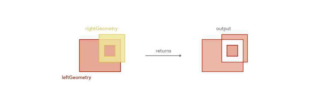
Example
Returns a polygon representing areas where both inputs do not overlap
var geom2 = Polygon({ ... });
SymmetricDifference($feature, geom2);Touches
Touches(geometry1, geometry2) -> Boolean
Function bundle: Geometry
Indicates if one geometry touches another geometry. In the graphic below, the red highlight indicates the scenarios where the function will return true.
Feature geometries in the visualization and labeling profiles are generalized according to the view's scale resolution to improve drawing performance. Therefore, using a feature's geometry (i.e. $feature) as input to any geometry function in these contexts will return different results at each scale level. Other profiles, such as popup, provide the full resolution geometry.
Parameters
- geometry1: Geometry | Feature - The geometry to test the 'touches' relationship with
geometry2. - geometry2: Geometry | Feature - The geometry to test the 'touches' relationship with
geometry1.
Return value: Boolean
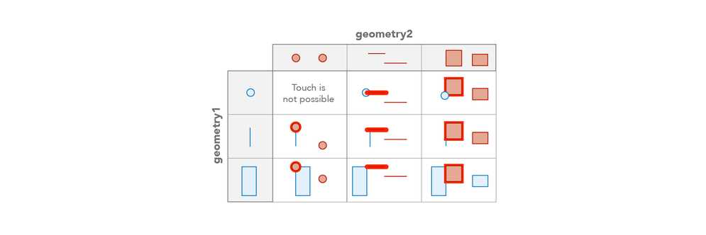
Example
Returns true if the geometries touch
var geom2 = Polygon({ ... });
Touches($feature, geom2);Union
This function has 2 signatures:
Union(geometries) -> Geometry
Function bundle: Geometry
Constructs the set-theoretic union of the geometries or features in an input array and returns a single Geometry. All inputs must have the same geometry type and share the same spatial reference.
Be aware that using $feature as input to this function will yield results only as precise as the view's scale resolution. Therefore values returned from expressions using this function may change after zooming between scales.
Parameter
- geometries: Array<Geometry> | Array<Feature> - An array of geometries or an array of features to union into a single geometry. This can be any number of geometries.
Return value: Geometry
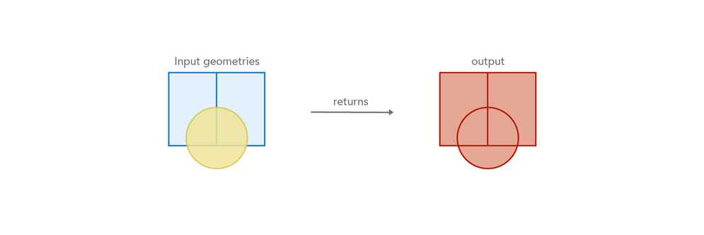
Example
var geom2 = Polygon({ ... });
Union([ $feature, geom2 ]);Union(geometry1, [geometry2, ..., geometryN]?) -> Geometry
Function bundle: Geometry
Constructs the set-theoretic union of a list of geometries and returns a single Geometry. All inputs must have the same geometry type and share the same spatial reference.
Be aware that using $feature as input to this function will yield results only as precise as the view's scale resolution. Therefore values returned from expressions using this function may change after zooming between scales.
Parameters
- geometry1: Geometry | Feature - A geometry to union into a single geometry with the other geometries.
- [geometry2, ..., geometryN] (Optional): Geometry | Feature - An ongoing list of geometries or features to union into a single geometry. This can be any number of geometries.
Return value: Geometry
Example
var geom2 = Polygon({ ... });
var geom3 = Polygon({ ... });
var geom4 = Polygon({ ... });
Union(Geometry($feature), geom2, geom3, geom4);Within
Within(innerGeometry, outerGeometry) -> Boolean
Function bundle: Geometry
Indicates if one geometry is within another geometry. In the graphic below, the red highlight indicates the scenarios where the function will return true.
Feature geometries in the visualization and labeling profiles are generalized according to the view's scale resolution to improve drawing performance. Therefore, using a feature's geometry (i.e. $feature) as input to any geometry function in these contexts will return different results at each scale level. Other profiles, such as popup, provide the full resolution geometry.
Parameters
- innerGeometry: Geometry | Feature - The base geometry that is tested for the 'within' relationship to
outer.Geometry - outerGeometry: Geometry | Feature - The comparison geometry that is tested for the 'contains' relationship to
inner.Geometry
Return value: Boolean
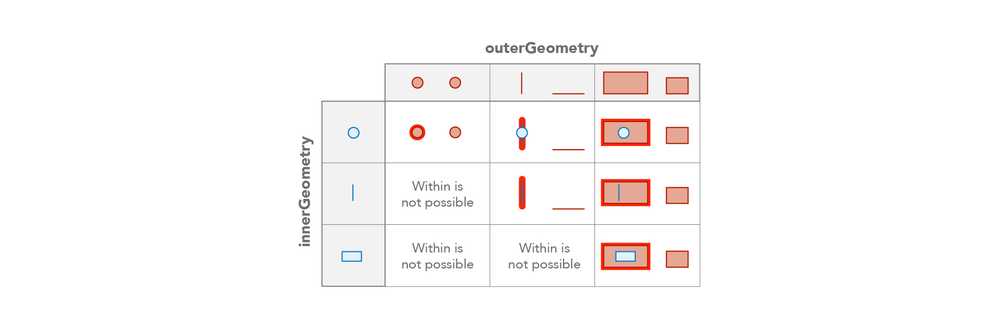
Example
Returns true if the feature is within the given polygon
var outerGeom = Polygon({ ... });
Within($feature, outerGeom);