 Hide Table of Contents
 Analysis
 Dynamic Layers
 Editing
 Feature Layers
 Feature Table
 Graphics
 Map
Map
 Mobile
 Online and Portal
 Popups and Info Windows
 Query and Select
 Renderers, Symbols, Visualization
 Search

Explore in the sandbox
Open in CodePen
View live sample
Description
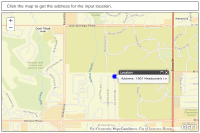
Reverse geocoding determines the address of a given point on a map. This sample shows how to do reverse geocoding with the ArcGIS JavaScript API.
Both reverse geocoding and regular geocoding require use of the Locator class and an ArcGIS Server geocode service. To reverse geocode, you call the locationToAddress() method (as opposed to addressToLocations for regular geocoding). The following sample shows how to add a listener that captures the mouse click event and calls locationToAddress for the clicked point.
A listener for the location-to-address-complete event then passes the best AddressCandidate to a callback function. That function then associates the candidate's point with a graphic and adds it to the map. The function also uses an InfoTemplate to format an InfoWindow that will appear when the graphic is clicked. Notice that the map point of the address result needs to be converted to a screen point in order to anchor the InfoWindow.
Code
<!DOCTYPE html>
<html>
  <head>
    <meta http-equiv="Content-Type" content="text/html; charset=utf-8">

    <meta name="viewport" content="initial-scale=1, maximum-scale=1,user-scalable=no">
    <title>Find Address</title>
    <link rel="stylesheet" href="https://js.arcgis.com/3.46/dijit/themes/claro/claro.css">
    <link rel="stylesheet" href="https://js.arcgis.com/3.46/esri/css/esri.css">

    <style>
      html, body { height: 100%; width: 100%; margin: 0; padding: 0; }
      #map {
        padding: 0;
        border: solid 2px #666;
        margin: 0 5px 5px 5px;
      }
      #header {
        border: solid 2px #666;
        color: #666;
        font-family: sans-serif;
        font-size: 1.1em;
        height: auto;
        margin: 5px;
        overflow: hidden;
        padding: 10px 0 10px 20px;
        text-align:left;
      }
      .roundedCorners {
        border-radius: 5px;
      }
    </style>

    <script src="https://js.arcgis.com/3.46/"></script>
    <script>
      var map;
      require([
        "esri/map", "esri/tasks/locator", "esri/graphic",
        "esri/geometry/webMercatorUtils",
        "esri/symbols/SimpleMarkerSymbol", "esri/symbols/SimpleLineSymbol",
        "esri/InfoTemplate", "esri/Color",
        "dojo/number", "dojo/parser", "dojo/dom", "dijit/registry",

        "dijit/layout/BorderContainer", "dijit/layout/ContentPane", "dojo/domReady!"
      ], function(
        Map, Locator, Graphic,
        webMercatorUtils,
        SimpleMarkerSymbol, SimpleLineSymbol,
        InfoTemplate, Color,
        number, parser, dom, registry
      ) {
        parser.parse();

        map = new Map("map", {
          basemap: "streets-vector",
          center: [-95.273, 38.95],
          zoom: 14
        });

        var locator = new Locator("https://geocode.arcgis.com/arcgis/rest/services/World/GeocodeServer");

        var infoTemplate = new InfoTemplate("Location", "Address: ${Address}");
        var symbol = new SimpleMarkerSymbol(
          SimpleMarkerSymbol.STYLE_CIRCLE,
          15,
          new SimpleLineSymbol(
            SimpleLineSymbol.STYLE_SOLID,
            new Color([0, 0, 255, 0.5]),
            8
          ),
          new Color([0, 0, 255])
        );

        locator.on("location-to-address-complete", function(evt) {
          if (evt.address.address) {
            var address = evt.address.address;
            var location = webMercatorUtils.geographicToWebMercator(evt.address.location);
            //this service returns geocoding results in geographic - convert to web mercator to display on map
            // var location = webMercatorUtils.geographicToWebMercator(evt.location);
            var graphic = new Graphic(location, symbol, address, infoTemplate);
            map.graphics.add(graphic);

            map.infoWindow.setTitle(graphic.getTitle());
            map.infoWindow.setContent(graphic.getContent());

            //display the info window with the address information
            var screenPnt = map.toScreen(location);
            map.infoWindow.resize(200,100);
            map.infoWindow.show(screenPnt, map.getInfoWindowAnchor(screenPnt));
          }
        });

        map.on("click", function(evt) {
          map.graphics.clear();
          locator.locationToAddress(webMercatorUtils.webMercatorToGeographic(evt.mapPoint), 100);
        });
      });
    </script>
  </head>
  <body class="claro">
    <div id="mainWindow" data-dojo-type="dijit/layout/BorderContainer"
         data-dojo-props="design:'headline', gutters:false"
         style="width:100%; height:100%;">

      <div id="header" class="roundedCorners"
           data-dojo-type="dijit/layout/ContentPane"
           data-dojo-props="region:'top'">

        <span>Click the map to get the address for the input location.</span>

      </div>

      <div id="map" class="roundedCorners"
           data-dojo-type="dijit/layout/ContentPane"
           data-dojo-props="region:'center'">
      </div>

    </div>
  </body>
</html>