Use pictures for markers.
Use case
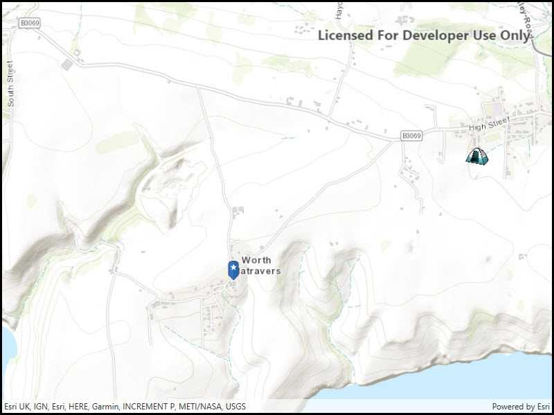
When marking geoelements on a map, using custom, unique symbols can be helpful for highlighting and differentiating between locations. For example, a tourism office may use pictures of landmarks as symbols on an online map or app, to help prospective visitors to orient themselves more easily around a city.
How to use the sample
When launched, this sample displays a map with picture marker symbols. Pan and zoom to explore the map.
How it works
- Create a
PictureMarkerSymbolusing the URI to an online or local image or a JavaFX Image (platform dependent). - Create a
Graphicand set its symbol to the picture marker symbol.
Relevant API
- PictureMarkerSymbol
About the data
The picture marker symbols in this sample are all constructed from different types of resources:
- Campsite symbol constructed from a URL
- Blue pin with a star stored in the resource folder that comes with the application
Tags
graphics, marker, picture, symbol, visualization
Sample Code
// Copyright 2016 Esri.
//
// Licensed under the Apache License, Version 2.0 (the "License"); you may not use this file except in compliance with the License.
// You may obtain a copy of the License at: http://www.apache.org/licenses/LICENSE-2.0
//
// Unless required by applicable law or agreed to in writing, software distributed under the License is distributed on an
// "AS IS" BASIS, WITHOUT WARRANTIES OR CONDITIONS OF ANY KIND, either express or implied. See the License for the specific
// language governing permissions and limitations under the License.
using Esri.ArcGISRuntime.Geometry;
using Esri.ArcGISRuntime.Mapping;
using Esri.ArcGISRuntime.Symbology;
using Esri.ArcGISRuntime.UI;
using System;
using System.IO;
using System.Linq;
using System.Reflection;
using System.Threading.Tasks;
using System.Windows;
namespace ArcGIS.WPF.Samples.RenderPictureMarkers
{
[ArcGIS.Samples.Shared.Attributes.Sample(
name: "Picture marker symbol",
category: "Symbology",
description: "Use pictures for markers.",
instructions: "When launched, this sample displays a map with picture marker symbols. Pan and zoom to explore the map.",
tags: new[] { "graphics", "marker", "picture", "symbol", "visualization" })]
[ArcGIS.Samples.Shared.Attributes.EmbeddedResource(@"PictureMarkerSymbols\pin_star_blue.png")]
public partial class RenderPictureMarkers
{
public RenderPictureMarkers()
{
InitializeComponent();
// Create the UI, setup the control references and execute initialization
_ = Initialize();
}
private async Task Initialize()
{
// Create new Map with basemap
Map myMap = new Map(BasemapStyle.ArcGISTopographic);
// Create and set initial map area
Envelope initialLocation = new Envelope(
-229835, 6550763, -222560, 6552021,
SpatialReferences.WebMercator);
myMap.InitialViewpoint = new Viewpoint(initialLocation);
// Assign the map to the MapView
MyMapView.Map = myMap;
// Create overlay to where graphics are shown
GraphicsOverlay overlay = new GraphicsOverlay();
// Add created overlay to the MapView
MyMapView.GraphicsOverlays.Add(overlay);
// Add graphics using different source types
CreatePictureMarkerSymbolFromUrl(overlay);
try
{
await CreatePictureMarkerSymbolFromResources(overlay);
}
catch (Exception e)
{
MessageBox.Show(e.ToString(), "Error");
}
}
private void CreatePictureMarkerSymbolFromUrl(GraphicsOverlay overlay)
{
// Create uri to the used image
Uri symbolUri = new Uri(
"https://static.arcgis.com/images/Symbols/OutdoorRecreation/Camping.png");
// Create new symbol using asynchronous factory method from uri.
PictureMarkerSymbol campsiteSymbol = new PictureMarkerSymbol(symbolUri)
{
Width = 40,
Height = 40
};
// Create location for the campsite
MapPoint campsitePoint = new MapPoint(-223560, 6552021, SpatialReferences.WebMercator);
// Create graphic with the location and symbol
Graphic campsiteGraphic = new Graphic(campsitePoint, campsiteSymbol);
// Add graphic to the graphics overlay
overlay.Graphics.Add(campsiteGraphic);
}
private async Task CreatePictureMarkerSymbolFromResources(GraphicsOverlay overlay)
{
// Hold a reference to the picture marker symbol
PictureMarkerSymbol pinSymbol;
// Get current assembly that contains the image
Assembly currentAssembly = Assembly.GetExecutingAssembly();
// Get the resource name of the blue pin image
string resourceStreamName = this.GetType().Assembly.GetManifestResourceNames().Single(str => str.EndsWith("pin_star_blue.png"));
// Load the blue pin resource stream
using (Stream resourceStream = this.GetType().Assembly.
GetManifestResourceStream(resourceStreamName))
{
// Create new symbol using asynchronous factory method from stream
pinSymbol = await PictureMarkerSymbol.CreateAsync(resourceStream);
pinSymbol.Width = 50;
pinSymbol.Height = 50;
}
// Create location for the pint
MapPoint pinPoint = new MapPoint(-226773, 6550477, SpatialReferences.WebMercator);
// Create graphic with the location and symbol
Graphic pinGraphic = new Graphic(pinPoint, pinSymbol);
// Add graphic to the graphics overlay
overlay.Graphics.Add(pinGraphic);
}
}
}