Demonstrates how to animate a graphic's position and rotation and follow it using a OrbitGeoElementCameraController. Also shows how to combine a SceneView and MapView in an MVC application with property binding.
Use case
Visualize movement through a 3D landscape.
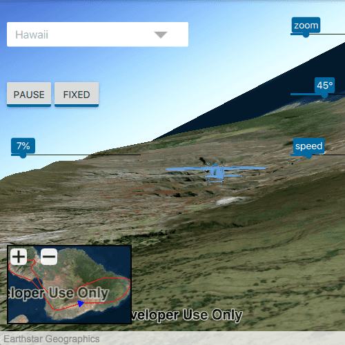
How to use the sample
Animation Controls (Top Left Corner):
- Select a mission -- selects a location with a route for the plane to fly
- Play/Pause -- toggles playing and stopping the animation
- Fixed/Follow -- toggles the camera's free cam mode and follow
- Mission progress -- shows how far along the route the plane is. Slide to change keyframe in animation
Camera Controls (Top Right Corner):
- Camare zoom -- distance between camera and plane
- Camera angle -- viewing angle between camera and plane
- Flight speed -- controls speed of animation
2D Map Controls (Bottom Left Corner):
- Plus and Minus -- controls distance of 2D view from ground level
How it works
- Create a
GraphicsOverlayand add it to theSceneView. - Create a
ModelSceneSymbolobject. - Create a
Graphicobject and set its geometry to aPoint. - Set the
ModelSceneSymbolobject to the graphic. - Add heading, pitch, and roll attributes to the graphic. Get the attributes from the graphic with
Graphic::attributes. - Create a
SimpleRendererobject and set its expression properties. - Add graphic and a renderer to the graphics overlay.
- Create a
OrbitGeoElementCameraControllerwhich is set to target the graphic. - Assign the camera controller to the
SceneView. - Update the graphic's location, heading, pitch, and roll.
Relevant API
- Camera
- GlobeCameraController
- Graphic
- GraphicsOverlay
- ModelSceneSymbol
- OrbitGeoElementCameraController
- Renderer
- Scene
- SceneProperties
- SceneView
- SurfacePlacement
Offline Data
Read more about how to set up the sample's offline data here.
| Link | Local Location |
|---|---|
| Model Marker Symbol Data | <userhome>/ArcGIS/Runtime/Data/3D/Bristol/Collada/Bristol.dae |
| GrandCanyon.csv mission data | <userhome>/ArcGIS/Runtime/Data/3D/Missions/GrandCanyon.csv |
| Hawaii.csv mission data | <userhome>/ArcGIS/Runtime/Data/3D/Missions/Hawaii.csv |
| Pyrenees.csv mission data | <userhome>/ArcGIS/Runtime/Data/3D/Missions/Pyrenees.csv |
| Snowdon.csv mission data | <userhome>/ArcGIS/Runtime/Data/3D/Missions/Snowdon.csv |
Tags
animation, camera, heading, pitch, roll, rotation, visualize
Sample Code
// [WriteFile Name=Animate3DSymbols, Category=Scenes]
// [Legal]
// Copyright 2016 Esri.
// Licensed under the Apache License, Version 2.0 (the "License");
// you may not use this file except in compliance with the License.
// You may obtain a copy of the License at
// http://www.apache.org/licenses/LICENSE-2.0
// Unless required by applicable law or agreed to in writing, software
// distributed under the License is distributed on an "AS IS" BASIS,
// WITHOUT WARRANTIES OR CONDITIONS OF ANY KIND, either express or implied.
// See the License for the specific language governing permissions and
// limitations under the License.
// [Legal]
#ifdef PCH_BUILD
#include "pch.hpp"
#endif // PCH_BUILD
#include "Animate3DSymbols.h"
#include "ArcGISTiledElevationSource.h"
#include "Camera.h"
#include "DistanceCompositeSceneSymbol.h"
#include "GlobeCameraController.h"
#include "GraphicsOverlay.h"
#include "Map.h"
#include "MapQuickView.h"
#include "ModelSceneSymbol.h"
#include "OrbitGeoElementCameraController.h"
#include "PointCollection.h"
#include "Polyline.h"
#include "PolylineBuilder.h"
#include "Scene.h"
#include "SceneQuickView.h"
#include "SceneViewTypes.h"
#include "SimpleMarkerSymbol.h"
#include "SimpleMarkerSceneSymbol.h"
#include "SimpleRenderer.h"
#include "SpatialReference.h"
#include "MissionData.h"
#include "MapTypes.h"
#include "SymbolTypes.h"
#include "GraphicsOverlayListModel.h"
#include "GraphicListModel.h"
#include "Surface.h"
#include "ElevationSourceListModel.h"
#include "LayerSceneProperties.h"
#include "RendererSceneProperties.h"
#include "AttributeListModel.h"
#include "Graphic.h"
#include "Viewpoint.h"
#include "SimpleLineSymbol.h"
#include <QFileInfo>
#include <QFuture>
#include <QStringListModel>
#include <QtCore/qglobal.h>
#include <QStandardPaths>
using namespace Esri::ArcGISRuntime;
// helper method to get cross platform data path
namespace
{
QString defaultDataPath()
{
QString dataPath;
#ifdef Q_OS_IOS
dataPath = QStandardPaths::writableLocation(QStandardPaths::DocumentsLocation);
#else
dataPath = QStandardPaths::writableLocation(QStandardPaths::HomeLocation);
#endif
return dataPath;
}
} // namespace
using namespace Esri::ArcGISRuntime;
const QString Animate3DSymbols::HEADING = QStringLiteral("heading");
const QString Animate3DSymbols::ROLL = QStringLiteral("roll");
const QString Animate3DSymbols::PITCH = QStringLiteral("pitch");
const QString Animate3DSymbols::ANGLE = QStringLiteral("angle");
Animate3DSymbols::Animate3DSymbols(QQuickItem* parent /* = nullptr */):
QQuickItem(parent),
m_dataPath(defaultDataPath() + "/ArcGIS/Runtime/Data/3D"),
m_missionsModel(new QStringListModel({QStringLiteral("Grand Canyon"),
QStringLiteral("Hawaii"),
QStringLiteral("Pyrenees"),
QStringLiteral("Snowdon")},
this)),
m_missionData(new MissionData())
{
}
Animate3DSymbols::~Animate3DSymbols() = default;
void Animate3DSymbols::init()
{
qmlRegisterType<SceneQuickView>("Esri.Samples", 1, 0, "SceneView");
qmlRegisterType<MapQuickView>("Esri.Samples", 1, 0, "MapView");
qmlRegisterType<Animate3DSymbols>("Esri.Samples", 1, 0, "Animate3DSymbolsSample");
qmlRegisterUncreatableType<QAbstractListModel>("Esri.Samples", 1, 0, "AbstractListModel", "AbstractListModel is uncreateable");
}
void Animate3DSymbols::componentComplete()
{
QQuickItem::componentComplete();
// find QML SceneView component
m_sceneView = findChild<SceneQuickView*>("sceneView");
// create a new scene instance
Scene* scene = new Scene(BasemapStyle::ArcGISImageryStandard, this);
// set scene on the scene view
m_sceneView->setArcGISScene(scene);
// for use when not in following mode
m_globeController = new GlobeCameraController(this);
// create a new elevation source
ArcGISTiledElevationSource* elevationSource = new ArcGISTiledElevationSource(
QUrl("https://elevation3d.arcgis.com/arcgis/rest/services/WorldElevation3D/Terrain3D/ImageServer"), this);
// add the elevation source to the scene to display elevation
scene->baseSurface()->elevationSources()->append(elevationSource);
// create a new graphics overlay and add it to the sceneview
GraphicsOverlay* sceneOverlay = new GraphicsOverlay(this);
sceneOverlay->setSceneProperties(LayerSceneProperties(SurfacePlacement::Absolute));
m_sceneView->graphicsOverlays()->append(sceneOverlay);
SimpleRenderer* renderer3D = new SimpleRenderer(this);
RendererSceneProperties renderProperties = renderer3D->sceneProperties();
renderProperties.setHeadingExpression(QString("[%1]").arg(HEADING));
renderProperties.setPitchExpression(QString("[%1]").arg(PITCH));
renderProperties.setRollExpression(QString("[%1]").arg(ROLL));
renderer3D->setSceneProperties(renderProperties);
sceneOverlay->setRenderer(renderer3D);
// find QML MapView component
m_mapView = findChild<MapQuickView*>("mapView");
m_mapView->setAttributionTextVisible(false);
// set up mini map
Map* map = new Map(BasemapStyle::ArcGISImageryStandard, this);
m_mapView->setMap(map);
// create a graphics overlay for the mini map
GraphicsOverlay* mapOverlay = new GraphicsOverlay(this);
m_mapView->graphicsOverlays()->append(mapOverlay);
// set up route graphic
createRoute2d(mapOverlay);
// set up overlay 2D graphic
createModel2d(mapOverlay);
}
void Animate3DSymbols::setMissionFrame(int newFrame)
{
if (!m_missionData||
newFrame < 0 ||
m_frame == newFrame)
return;
m_frame = newFrame;
emit missionFrameChanged();
}
void Animate3DSymbols::animate()
{
if (!m_missionData)
return;
if (missionFrame() < missionSize())
{
// get the data for this stage in the mission
const MissionData::DataPoint& dp = m_missionData->dataAt(missionFrame());
// move 3D graphic to the new position
m_graphic3d->setGeometry(dp.m_pos);
// update attribute expressions to immediately update rotation
m_graphic3d->attributes()->replaceAttribute(HEADING, dp.m_heading);
m_graphic3d->attributes()->replaceAttribute(PITCH, dp.m_pitch);
m_graphic3d->attributes()->replaceAttribute(ROLL, dp.m_roll);
// move 2D graphic to the new position
m_graphic2d->setGeometry(dp.m_pos);
m_symbol2d->setAngle(dp.m_heading);
}
// increment the frame count
emit nextFrameRequested();
}
void Animate3DSymbols::changeMission(const QString &missionNameStr)
{
setMissionFrame(0);
// read the mission data from the samples .csv files
QString formattedname = missionNameStr;
m_missionData->parse(m_dataPath + "/Missions/" + formattedname.remove(" ") + ".csv");
// if the mission was loaded successfully, move to the start position
if (missionReady() && m_routeGraphic)
{
// create a polyline representing the route for the mission
PolylineBuilder* routeBldr = new PolylineBuilder(SpatialReference::wgs84(), this);
for (int i = 0; i < missionSize(); ++i)
{
const MissionData::DataPoint& dp = m_missionData->dataAt(i);
routeBldr->addPoint(dp.m_pos);
}
// set the polyline as a graphic on the mapView
m_routeGraphic->setGeometry(routeBldr->toGeometry());
m_mapView->setViewpointAndWait(Viewpoint(m_routeGraphic->geometry()));
createGraphic3D();
}
emit missionReadyChanged();
emit missionSizeChanged();
}
QAbstractListModel *Animate3DSymbols::missionsModel()
{
return m_missionsModel;
}
void Animate3DSymbols::setZoom(double zoomDist)
{
if (m_followingController)
{
m_followingController->setCameraDistance(zoomDist);
emit zoomChanged();
}
}
void Animate3DSymbols::setAngle(double angle)
{
if (m_followingController)
{
m_followingController->setCameraPitchOffset(angle);
emit angleChanged();
}
}
void Animate3DSymbols::createModel2d(GraphicsOverlay* mapOverlay)
{
if (m_symbol2d || m_graphic2d)
return;
// get the mission data for the frame
const MissionData::DataPoint& dp = m_missionData->dataAt(missionFrame());
// create a blue triangle symbol to represent the plane on the mini map
m_symbol2d = new SimpleMarkerSymbol(SimpleMarkerSymbolStyle::Triangle, Qt::blue, 10, this);
m_symbol2d->setAngle(dp.m_heading);
// create a graphic with the symbol
m_graphic2d = new Graphic(dp.m_pos, m_symbol2d, this);
mapOverlay->graphics()->append(m_graphic2d);
}
void Animate3DSymbols::createRoute2d(GraphicsOverlay* mapOverlay)
{
// Create a 2d graphic of a solid red line to represen the route of the mission
SimpleLineSymbol* routeSymbol = new SimpleLineSymbol(SimpleLineSymbolStyle::Solid, Qt::red, 1, this);
m_routeGraphic = new Graphic(this);
m_routeGraphic->setSymbol(routeSymbol);
mapOverlay->graphics()->append(m_routeGraphic);
}
void Animate3DSymbols::createGraphic3D()
{
if (!missionReady())
return;
// create the ModelSceneSymbol to be animated in the 3d view
if (!m_model3d)
m_model3d = new ModelSceneSymbol(QUrl(m_dataPath + "/Bristol/Collada/Bristol.dae"), 10.0f, this);
// get the mission data for the frame
const MissionData::DataPoint& dp = m_missionData->dataAt(missionFrame());
if (!m_graphic3d)
{
// create a graphic using the model symbol
m_graphic3d = new Graphic(dp.m_pos, m_model3d, this);
m_graphic3d->attributes()->insertAttribute(HEADING, dp.m_heading);
m_graphic3d->attributes()->insertAttribute(PITCH, dp.m_pitch);
m_graphic3d->attributes()->insertAttribute(ROLL, dp.m_roll);
// add the graphic to the graphics overlay
m_sceneView->graphicsOverlays()->at(0)->graphics()->append(m_graphic3d);
// create the camera controller to follow the graphic
m_followingController = new OrbitGeoElementCameraController(m_graphic3d, 500, this);
m_sceneView->setCameraController(m_followingController);
}
else
{
// update existing graphic's geometry and attributes
m_graphic3d->setGeometry(dp.m_pos);
m_graphic3d->attributes()->replaceAttribute(HEADING, dp.m_heading);
m_graphic3d->attributes()->replaceAttribute(PITCH, dp.m_pitch);
m_graphic3d->attributes()->replaceAttribute(ROLL, dp.m_roll);
}
}
void Animate3DSymbols::setFollowing(bool following)
{
if (following)
m_sceneView->setCameraController(m_followingController);
else
m_sceneView->setCameraController(m_globeController);
}
void Animate3DSymbols::zoomMapIn()
{
if (!m_mapView || !m_routeGraphic)
return;
// zoom the map view in, focusing on the position of the 2d graphic for the airplane
m_mapView->setViewpointAsync(Viewpoint((Point)m_routeGraphic->geometry(), m_mapView->mapScale() / m_mapZoomFactor));
}
void Animate3DSymbols::zoomMapOut()
{
if (!m_mapView || !m_routeGraphic)
return;
// zoom the map view out, focusing on the position of the 2d graphic for the airplane
m_mapView->setViewpointAsync(Viewpoint((Point)m_routeGraphic->geometry(), m_mapView->mapScale() * m_mapZoomFactor));
}
void Animate3DSymbols::viewWidthChanged(bool sceneViewIsWider)
{
if (!m_sceneView || !m_mapView)
{
return;
}
// only show the attribution text on the view with the widest visible extent
m_sceneView->setAttributionTextVisible(sceneViewIsWider);
m_mapView->setAttributionTextVisible(!sceneViewIsWider);
}
bool Animate3DSymbols::missionReady() const
{
if (!m_missionData)
return false;
return m_missionData->ready();
}
int Animate3DSymbols::missionSize() const
{
if (!m_missionData)
return 0;
return (int)m_missionData->size();
}
int Animate3DSymbols::missionFrame() const
{
return m_frame;
}
double Animate3DSymbols::zoom() const
{
return m_followingController ? m_followingController->cameraDistance() : 200.0;
}
double Animate3DSymbols::angle() const
{
return m_followingController ? m_followingController->cameraDistance() : 45.0;
}
double Animate3DSymbols::minZoom() const
{
return m_followingController ? m_followingController->minCameraDistance() : 0;
}