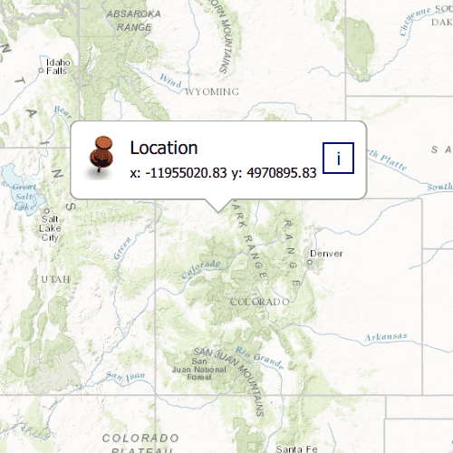
Show a callout with the latitude and longitude of user-tapped points.
Use case
Callouts are used to display temporary detail content on a map. You can display text and arbitrary UI controls in callouts.
How to use the sample
Tap anywhere on the map. A callout showing the WGS84 coordinates for the tapped point will appear.
How it works
- Listen for
mouseClickedsignal on the map view. - When the user taps, get the tapped location using the mouseEvent x and y coordinates,
MapQuickView::screenToLocation(mouseEvent.position().x(), mouseEvent.position().y()). - Create a string to display the coordinates; note that latitude and longitude in WGS84 map to the Y and X coordinates.
- Create a new callout definition using a title and the coordinate string.
- Display the callout by calling
setVisibleandsetLocationon theCalloutData.
Relevant API
- CalloutDefinition
- GeometryEngine::project
- GeoViewTappedEventArgs
- MapView::geoViewTapped
- MapView::showCalloutAt
Tags
balloon, bubble, callout, flyout, flyover, info window, popup, tap
Sample Code
// [WriteFile Name=ShowCallout, Category=DisplayInformation]
// [Legal]
// Copyright 2016 Esri.
// Licensed under the Apache License, Version 2.0 (the "License");
// you may not use this file except in compliance with the License.
// You may obtain a copy of the License at
// http://www.apache.org/licenses/LICENSE-2.0
// Unless required by applicable law or agreed to in writing, software
// distributed under the License is distributed on an "AS IS" BASIS,
// WITHOUT WARRANTIES OR CONDITIONS OF ANY KIND, either express or implied.
// See the License for the specific language governing permissions and
// limitations under the License.
// [Legal]
#ifdef PCH_BUILD
#include "pch.hpp"
#endif // PCH_BUILD
#include "ShowCallout.h"
#include "Map.h"
#include "MapQuickView.h"
#include "CalloutData.h"
#include "MapTypes.h"
#include "MapViewTypes.h"
#include "SpatialReference.h"
#include "Point.h"
#include "Viewpoint.h"
#include <QImage>
using namespace Esri::ArcGISRuntime;
ShowCallout::ShowCallout(QQuickItem* parent):
QQuickItem(parent)
{
}
ShowCallout::~ShowCallout() = default;
void ShowCallout::init()
{
qmlRegisterType<MapQuickView>("Esri.Samples", 1, 0, "MapView");
qmlRegisterType<ShowCallout>("Esri.Samples", 1, 0, "ShowCalloutSample");
qmlRegisterUncreatableType<CalloutData>("Esri.Samples", 1, 0, "CalloutData", "CalloutData is an uncreatable type");
}
void ShowCallout::componentComplete()
{
QQuickItem::componentComplete();
// find QML MapView component
m_mapView = findChild<MapQuickView*>("mapView");
m_mapView->setWrapAroundMode(WrapAroundMode::Disabled);
// Create a map using the topographic basemap
m_map = new Map(BasemapStyle::ArcGISTopographic, this);
m_map->setInitialViewpoint(Viewpoint(Point(-1.2e7, 5e6, SpatialReference::webMercator()), 1e7));
// Set map to map view
m_mapView->setMap(m_map);
//! [initialize callout]
m_mapView->calloutData()->setVisible(false);
m_mapView->calloutData()->setTitle("Location");
QImage image(":/Samples/DisplayInformation/ShowCallout/RedShinyPin.png");
m_mapView->calloutData()->setImage(image);
//! [initialize callout]
// display callout on mouseClicked
connect(m_mapView, &MapQuickView::mouseClicked, this, [this](QMouseEvent& mouseEvent){
if (m_mapView->calloutData()->isVisible())
m_mapView->calloutData()->setVisible(false);
else
{
// set callout position
Point mapPoint(m_mapView->screenToLocation(mouseEvent.position().x(), mouseEvent.position().y()));
m_mapView->calloutData()->setLocation(mapPoint);
// set detail as coordinates formatted to decimal numbers with precision 2
m_mapView->calloutData()->setDetail("x: " + QString::number(mapPoint.x(), 'f', 2) + " y: " + QString::number(mapPoint.y(), 'f', 2));
m_mapView->calloutData()->setVisible(true);
}
});
}