Get the elevation for a given point on a surface.
Use case
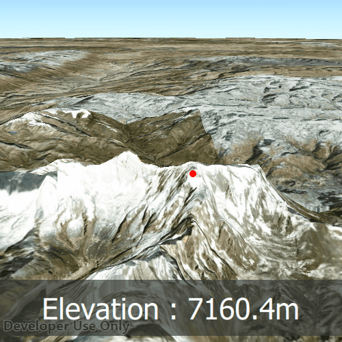
Knowing the elevation at a given point in a landscape can aid in navigation, planning and survey in the field.
How to use the sample
Click anywhere on the surface to get the elevation at that point.
How it works
- Create a
SceneViewandScenewith an imagery base map. - Set an
ArcGISTiledElevationSourceas the elevation source of the scene's base surface. - Use the
screenToBaseSurface(screenPoint)method on the scene view to convert the clicked screen point into a point on surface. - Use the
locationToElevation(surfacePoint)method on the base surface to asynchronously get the elevation.
Relevant API
- ArcGISTiledElevationSource
- BaseSurface
- ElevationSourceListModel
- SceneView
Additional information
Calling locationToElevation(surfacePoint) retrieves the most accurate available elevation value at a given point which requires it to go to the server or local raster file and load the highest level of detail of data for the target location and return the elevation value.
If multiple elevation sources are present in the surface the top most visible elevation source with a valid elevation in the given location is used to determine the result.
Tags
elevation, surface
Sample Code
GetElevationAtPoint.qml
// [WriteFile Name=GetElevationAtPoint, Category=Scenes]
// [Legal]
// Copyright 2019 Esri.
// Licensed under the Apache License, Version 2.0 (the "License");
// you may not use this file except in compliance with the License.
// You may obtain a copy of the License at
// http://www.apache.org/licenses/LICENSE-2.0
// Unless required by applicable law or agreed to in writing, software
// distributed under the License is distributed on an "AS IS" BASIS,
// WITHOUT WARRANTIES OR CONDITIONS OF ANY KIND, either express or implied.
// See the License for the specific language governing permissions and
// limitations under the License.
// [Legal]
import Esri.ArcGISRuntime
import QtQuick
import QtQuick.Controls
Rectangle {
id: rootRectangle
clip: true
width: 800
height: 600
// The position on the surface that was last queried for altitude, so the marker can be set in the onLocationToElevationResultChanged callback.
property Point lastQueriedSurfacePos : null
SceneView {
id: sceneView
anchors.fill: parent
Scene {
id: scene
Basemap {
initStyle: Enums.BasemapStyleArcGISImageryStandard
}
Surface {
id: elevationSurface
ArcGISTiledElevationSource {
url: "https://elevation3d.arcgis.com/arcgis/rest/services/WorldElevation3D/Terrain3D/ImageServer"
}
// When location has changed, set the elevation text to display new elevation, and move the elevationMarker to the queried-for position on the surface.
onLocationToElevationResultChanged:
if(locationToElevationStatus === Enums.TaskStatusCompleted) {
// Display elevation value in meters, round to a single decimal place.
elevationDisplaytext.text = "Elevation : " + Math.round(locationToElevationResult * 10) / 10 + "m"
elevationMarker.geometry = lastQueriedSurfacePos;
}
}
}
// A graphics overlay to display the elevaton marker.
GraphicsOverlay {
id: graphicsOverlay
Graphic {
id: elevationMarker
symbol: elevationMarkerSymbol
}
}
// A simple red dot, displays the point elevation is queried at.
SimpleMarkerSymbol {
id: elevationMarkerSymbol
style: Enums.SimpleMarkerSymbolStyleCircle
color: "red"
size: 10
}
// When the mouse is clicked, convert mouse screen-position to position on surface, then invoke a query for the elevation of that position.
onMouseClicked: mouse => {
lastQueriedSurfacePos = sceneView.screenToBaseSurface(mouse.x, mouse.y)
elevationSurface.locationToElevation(lastQueriedSurfacePos)
}
Component.onCompleted: {
// Set the focus on SceneView to initially enable keyboard navigation
forceActiveFocus();
// Once the scene view has loaded, apply the camera.
setViewpointCameraAndWait(camera);
}
}
// Create the camera to be used as the scene view's viewpoint, looking at the Himalayan mountain range.
Camera {
id: camera
location: Point {
x: 83.9 // Longitude
y: 28.4 // Latitude
z: 10010.0 // Altiude
spatialReference: SpatialReference { wkid: 4326 }
}
heading: 10.0
pitch: 83.9
roll: 0.0
}
// Background rectangle for elevation display
Rectangle {
anchors {
bottom: parent.bottom
left: parent.left
right: parent.right
margins: 30
}
color: Qt.rgba(0.2, 0.2, 0.2, 0.65);
height: childrenRect.height
// Elevation display text
Text {
id: elevationDisplaytext
anchors {
horizontalCenter: parent.horizontalCenter
}
color: "white"
padding: 15
font.pointSize: 32
// For vertical screens, keep the text within the bounding box via scaling down.
scale: Math.min(1, (parent.width - padding) / contentWidth)
// Display elevation value in meters, round to a single decimal place.
text: "Elevation : 0"
}
}
// Display an indictor when the elevation query is running, since it might take a couple of seconds
BusyIndicator {
running: elevationSurface.locationToElevationStatus === Enums.TaskStatusInProgress
anchors.centerIn: parent
width: Math.min(parent.width, parent.height) / 6.0
height: width
}
}