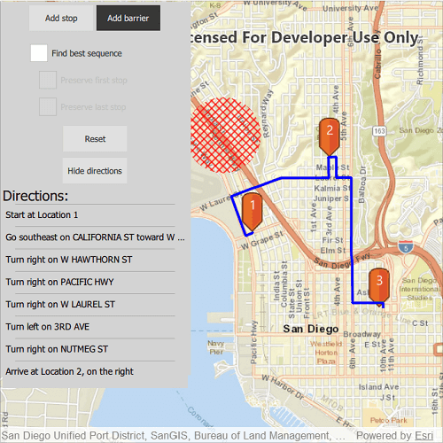
Find a route that reaches all stops without crossing any barriers.
Use case
You can define barriers to avoid unsafe areas, for example flooded roads, when planning the most efficient route to evacuate a hurricane zone. When solving a route, barriers allow you to define portions of the road network that cannot be traversed. You could also use this functionality to plan routes when you know an area will be inaccessible due to a community activity like an organized race or a market night.
In some situations, it is further beneficial to find the most efficient route that reaches all stops, reordering them to reduce travel time. For example, a delivery service may target a number of drop-off addresses, specifically looking to avoid congested areas or closed roads, arranging the stops in the most time-effective order.
How to use the sample
Click 'Add stop' to add stops to the route. Click 'Add barrier' to add areas that can't be crossed by the route. Select 'Find best sequence' to allow stops to be re-ordered in order to find an optimum route. Select 'Preserve first stop' to preserve the first stop. Select 'Preserve last stop' to preserve the last stop.
How it works
- Construct a
RouteTaskwith the URL to a Network Analysis route service. - Get the default
RouteParametersfor the service, and create the desiredStops andPolygonBarriers. - Add the stops and barriers to the route's parameters,
routeParameters.setStops(routeStops)androuteParameters.setPolygonBarriers(routeBarriers). - Set the
returnStopsandreturnDirectionstotrue. - If the user will accept routes with the stops in any order, set
findBestSequencetotrueto find the most optimal route. - If the user has a definite start point, set
preserveFirstStoptotrue. - If the user has a definite final destination, set
preserveLastStoptotrue. - Call
routeTask.solveRoute(routeParameters)to get aRouteResult. - Get the first returned route by calling
solveRouteResult.routes[0]. - Get the geometry from the route to display the route to the map.
Relevant API
- DirectionManeuverListModel
- PolygonBarrier
- Route
- RouteParameters
- RouteResult
- RouteTask
- Stop
About the data
This sample uses an Esri-hosted sample street network for San Diego.
Tags
barriers, best sequence, directions, maneuver, network analysis, routing, sequence, stop order, stops
Sample Code
// [WriteFile Name=RouteAroundBarriers, Category=Routing]
// [Legal]
// Copyright 2020 Esri.
// Licensed under the Apache License, Version 2.0 (the "License");
// you may not use this file except in compliance with the License.
// You may obtain a copy of the License at
// http://www.apache.org/licenses/LICENSE-2.0
// Unless required by applicable law or agreed to in writing, software
// distributed under the License is distributed on an "AS IS" BASIS,
// WITHOUT WARRANTIES OR CONDITIONS OF ANY KIND, either express or implied.
// See the License for the specific language governing permissions and
// limitations under the License.
// [Legal]
import Qt.labs.platform
import QtQuick
import QtQuick.Controls
import Esri.ArcGISRuntime
import QtQuick.Layouts
import QtQuick.Dialogs
Rectangle {
id: rootRectangle
clip: true
width: 800
height: 600
readonly property url pinUrl: "qrc:/Samples/Routing/RouteAroundBarriers/orange_symbol.png"
readonly property url routeTaskUrl: "https://sampleserver6.arcgisonline.com/arcgis/rest/services/NetworkAnalysis/SanDiego/NAServer/Route"
readonly property int checkBoxPadding: 20
property var stopsList: []
property var barriersList: []
property var createAndDisplayRoute
property var routeParameters: null
property var directionListModel: null
property var myRoute: null
property bool addStops: true
property bool addBarriers: false
property bool findBestSeq: false
property bool preserveFirstStp: false
property bool preserveLastStp: false
MessageDialog {
id: messageDialog
text: "No route found."
visible: false
onRejected: {
visible = false;
}
}
ButtonGroup {
id: buttonGroup
buttons: buttonsRow.children
}
MapView {
id: mapView
anchors.fill: parent
Component.onCompleted: {
// Set the focus on MapView to initially enable keyboard navigation
forceActiveFocus();
}
Map {
Basemap {
initStyle: Enums.BasemapStyleArcGISStreets
}
ViewpointCenter {
Point {
x: -117.1750
y: 32.727
SpatialReference {
wkid: 4326
}
}
targetScale: 40000
}
}
GraphicsOverlay {
id: stopsOverlay
}
PictureMarkerSymbol {
id: pinSymbol
url: pinUrl
height: 50
width: 50
offsetY: height/2
}
GraphicsOverlay {
id: routeOverlay
SimpleRenderer {
SimpleLineSymbol {
style: Enums.SimpleLineSymbolStyleSolid
color: "blue"
width: 3
}
}
}
GraphicsOverlay {
id: barriersOverlay
}
SimpleFillSymbol {
id: barrierSymbol
style: Enums.SimpleFillSymbolStyleDiagonalCross
color: "red"
outline: SimpleLineSymbol {
style: Enums.SimpleLineSymbolStyleNull
}
}
RouteTask {
id: routeTask
url: routeTaskUrl
Component.onCompleted: {
load();
}
onLoadStatusChanged: {
if (loadStatus === Enums.LoadStatusLoaded) {
createDefaultParameters();
}
}
onCreateDefaultParametersStatusChanged: {
if (createDefaultParametersStatus === Enums.TaskStatusCompleted) {
routeParameters = createDefaultParametersResult;
// set flags to return stops and directions
routeParameters.returnStops = true;
routeParameters.returnDirections = true;
}
}
function createAndDisplayRoute() {
if (stopsList.length > 1) {
// clear the previous route, if it exists
routeOverlay.graphics.clear();
routeParameters.setStops(stopsList);
routeParameters.setPolygonBarriers(barriersList);
routeParameters.findBestSequence = findBestSeq;
routeParameters.preserveFirstStop = preserveFirstStp;
routeParameters.preserveLastStop = preserveLastStp;
solveRoute(routeParameters);
}
}
onSolveRouteStatusChanged: {
if (solveRouteStatus === Enums.TaskStatusCompleted) {
if (solveRouteResult.routes.length === 0) {
messageDialog.visible = true;
return;
}
// get the first route and add to graphics overlay
myRoute = solveRouteResult.routes[0];
const routeGeometry = myRoute.routeGeometry;
const routeGraphic = ArcGISRuntimeEnvironment.createObject("Graphic", {geometry: routeGeometry});
routeOverlay.graphics.append(routeGraphic);
directionListModel = myRoute.directionManeuvers;
}
}
}
onMouseClicked: mouse => {
const clickedPoint = mapView.screenToLocation(mouse.x, mouse.y);
if (addStops) {
// add stop to list of stops
const stopPoint = ArcGISRuntimeEnvironment.createObject("Stop", {geometry: clickedPoint});
stopsList.push(stopPoint);
// create a marker symbol and graphics, and add the graphics to the graphics overlay
const textSymbol = ArcGISRuntimeEnvironment.createObject("TextSymbol", {
text: stopsList.length,
color: "white",
size: 16,
horizontalAlignment: Enums.HorizontalAlignmentCenter,
verticalAlignment: Enums.VerticalAlignmentBottom
});
textSymbol.offsetY = pinSymbol.height/2;
const stopSymbol = ArcGISRuntimeEnvironment.createObject("CompositeSymbol");
stopSymbol.symbols.append(pinSymbol);
stopSymbol.symbols.append(textSymbol);
const stopGraphic = ArcGISRuntimeEnvironment.createObject("Graphic", {geometry: clickedPoint, symbol: stopSymbol});
stopsOverlay.graphics.append(stopGraphic);
routeTask.createAndDisplayRoute();
} else if (addBarriers) {
// create barrier and add to list of barriers
const barrierPolygon = GeometryEngine.buffer(clickedPoint, 500);
const barrier = ArcGISRuntimeEnvironment.createObject("PolygonBarrier", {geometry: barrierPolygon});
barriersList.push(barrier);
const barrierGraphic = ArcGISRuntimeEnvironment.createObject("Graphic", {geometry: barrierPolygon, symbol: barrierSymbol});
barriersOverlay.graphics.append(barrierGraphic);
routeTask.createAndDisplayRoute();
}
}
ColumnLayout {
spacing: 0
Layout.alignment: Qt.AlignTop
Rectangle {
id: backBox
z: 1
Layout.alignment: Qt.AlignLeft
Layout.margins: 3
Layout.bottomMargin: 0
width: Qt.platform.os === "ios" || Qt.platform.os === "android" ? 200 : 300
height: childrenRect.height
color: "lightgrey"
GridLayout {
id: grid
rows: 3
columns: 1
rowSpacing: 10
columnSpacing: 2
anchors.horizontalCenter: parent.horizontalCenter
Row {
id: buttonsRow
Layout.alignment: Qt.AlignHCenter
spacing: 5
padding: 5
Button {
id: stopButton
text: "Add stop"
checked: true
highlighted: checked
onClicked: {
checked = true;
}
onCheckedChanged: {
addStops = checked;
}
}
Button {
id: barrierButton
text: "Add barrier"
highlighted: checked
onClicked: {
checked = true;
}
onCheckedChanged: {
addBarriers = checked;
}
}
}
Column {
spacing: 2
CheckBox {
id: bestSequenceBox
text: "Find best sequence"
onCheckedChanged: {
findBestSeq = checked;
routeTask.createAndDisplayRoute();
}
}
CheckBox {
id: firstStopBox
text: "Preserve first stop"
leftPadding: checkBoxPadding
enabled: bestSequenceBox.checked
onCheckedChanged: {
preserveFirstStp = checked;
routeTask.createAndDisplayRoute();
}
}
CheckBox {
id: lastStopBox
text: "Preserve last stop"
leftPadding: checkBoxPadding
enabled: bestSequenceBox.checked
onCheckedChanged: {
preserveLastStp = checked;
routeTask.createAndDisplayRoute();
}
}
}
Row {
Layout.alignment: Qt.AlignHCenter
Button {
id: resetButton
text: "Reset"
onClicked: {
// clear stops
routeParameters.clearStops();
stopsList = [];
// clear barriers
routeParameters.clearPolygonBarriers();
barriersList = [];
// clear directions
directionListModel = [];
// clear graphics overlays
routeOverlay.graphics.clear();
stopsOverlay.graphics.clear();
barriersOverlay.graphics.clear();
}
}
}
Row {
Layout.alignment: Qt.AlignHCenter
Button {
id: hideShowDirectionsBtn
text: "Hide directions"
onClicked: {
if (text === "Hide directions") {
text = "Show directions";
} else {
text = "Hide directions";
}
}
}
}
}
}
// Create window for displaying the route directions
Rectangle {
id: directionWindow
Layout.alignment: Qt.AlignBottom
Layout.topMargin: 0
visible: true
Layout.preferredWidth: backBox.width
Layout.preferredHeight: 300
Layout.margins: 3
color: "lightgrey"
ScrollView {
anchors.fill: parent
ListView {
id: directionsView
clip: true
visible: hideShowDirectionsBtn.text === "Hide directions" ? true : false
anchors {
fill: parent
margins: 5
}
header: Text {
text: "Directions:"
font.pixelSize: 22
bottomPadding: 8
}
// set the model to the DirectionManeuverListModel returned from the route
model: directionListModel
delegate: directionDelegate
}
}
}
}
}
Component {
id: directionDelegate
Rectangle {
id: rect
width: parent.width
height: 35
color: directionWindow.color
Rectangle {
anchors {
top: parent.top;
left: parent.left;
right: parent.right;
topMargin: -8
leftMargin: 20
rightMargin: 20
}
color: "darkgrey"
height: 1
}
Text {
text: directionText
anchors {
fill: parent
leftMargin: 5
}
elide: Text.ElideRight
font.pixelSize: 14
}
}
}
}