Open an existing project
-
To launch Unreal Engine, open the Epic Games launcher and click on Library.
-
Choose the correct version and click Launch. Select the project from the project list.

Install the plugin
The ArcGIS Maps SDK for Unreal Engine should be installed in the project directory.
-
Exit Unreal Engine and close Visual Studio. Then create a Plugins folder in the main project directory.

-
Extract the ArcGISMapsSDK folder from the .zip file and copy it to the new Plugins folder.

-
Once your project is open, navigate to Edit -> Plugins in the menu bar to confirm the ArcGIS Maps SDK for Unreal Engine plugin is correctly installed.

For Unreal Engine 5.0
The steps below are for Unreal Engine 5.0 only. You can omit those if you are using Unreal Engine 5.1 or higher.
-
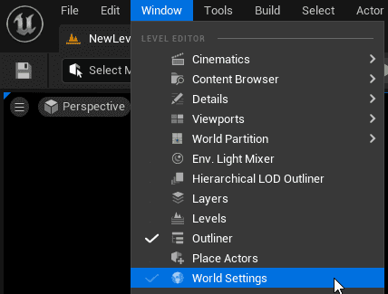
Navigate to Window > World Settings in the menu bar. This will open the World Settings panel.
-
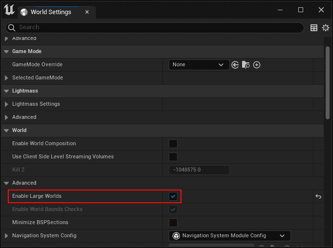
In the World Settings panel, go to the World group and open Advanced settings. Check the Enable Large Worlds option.
Manage existing content
To allow your project's existing Actors to track within an ArcGISMap with geographic coordinates, you can add an ArcGIS Location component.
You can find the script here:
ArcGISMapsSDK for Unreal Engine C++ Classes\ArcGISMapsSDK\Public\ArcGISMapsSDK\Components
To use the ArcGIS Location Component:
-
Click your Actor in the Outliner.
-
Click + Add button in the Details panel and search for ArcGIS Location to add the Component to your Actor. For more information on Components see Unreal Engine's documentation under Components section.
-
Make sure your Actor is selected in the Details panel and change the Mobility to Movable.

-
Click the ArcGIS Location in the Details panel and set the initial position and rotation. The ArcGIS Location Componentuses the pivot of the Actor as the setting point.

- X (Longitude) : Specifies the east–west position of the Actor on the Earth's surface. A projected position value for projected coordinate systems or a longitude value for geographic coordinate systems.
- Y (Latitude) : Specifies the north–south position of the Actor on the Earth's surface. A projected position value for projected coordinate systems or a latitude value for geographic coordinate systems.
- Z (Altitude): Sets the vertical distance of the Actor above the Earth. The units is depending on the spatial reference.
- Spatial Reference WKID: Well-Known ID (WKID) of the spatial reference for the X, Y and Z values. (Specifying the spatial reference with Well-Known Text (WKT) is not supported for the ArcGIS Location Component.)
- Heading: Sets the heading or up axis of the Actor. This is also known as yaw or azimuth. It represents the number of degrees by which the game object will be rotated, measured counterclockwise from the north. To rotate clockwise, use a negative value.
- Pitch: Sets the pitch or right axis of the Actor. Pitch is the equivalent of moving a plane's nose up or down (rotating along the axis that passes through the plane's wings). Positive values, looking forward, are above the horizon (pointing upward) and negative values are below the horizon (pointing downward).
- Roll: Sets the roll or forward axis of the Actor. Roll is the equivalent of tilting a plane's wings up or down (rotating along the axis that passes through the center of the plane from front to back). A zero value is perfectly horizontal. Positive values will tilt the left side upward (or right side downward). Negative values do the opposite.
GeoReferencing Plugin integration
You can use ArcGIS Maps SDK for Unreal Engine in a level that is using the GeoReferencing plugin. When you add ArcGIS Map Actor for the first time, it will pull the Origin Position values of the GeoReferencingSystem Actor to the ArcGIS Map Component. In ArcGIS Map Component, use the Update Geo Referencing System option to push the configuration to GeoReferencingSystem Actor.