Display your location history on the map.
Use case
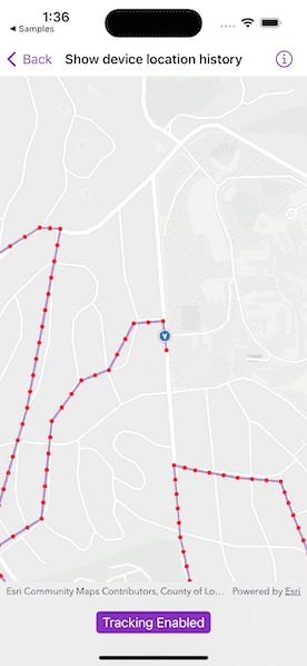
You can track device location history and display it as lines and points on the map. The history can be used to visualize how the user moved through the world, to retrace their steps, or to create new feature geometry. An unmapped trail, for example, could be added to the map using this technique.
How to use the sample
Tap "Start Tracking" to start tracking your location, which will appear as points on the map. A line will connect the points for easier visualization. Tap "Stop Tracking" to stop updating the location history. This sample uses a simulated data source. To track a user's real position, use the default location data source instead.
How it works
- If necessary, request location permission from the operating system.
- Create a graphics overlay to show each point and another graphics overlay for displaying the route line.
- Create an instance of
SimulatedLocationDataSourceand initialize it with a polyline, and start receiving location updates.- To track a user's real position, use the default system location data source for location display instead.
- Use the
for-await-insyntax to get the location updates fromLocationDataSource.locationsasynchronous stream. - Every time the location updates, display a new point on the map, and recreate the route line.
Relevant API
- Graphic
- GraphicsOverlay
- LocationDataSource
- LocationDisplay
- Map
- MapView
- PolylineBuilder
- SimpleLineSymbol
- SimpleMarkerSymbol
- SimpleRenderer
- SimulatedLocationDataSource
About the data
The default system location data source relies on Core Location, which works with device sensors.
A custom set of points is used to create a Polyline and initialize a SimulatedLocationDataSource. This simulated location data source enables easier testing and allows the sample to be used on devices without an actively updating GPS signal.
Tags
bread crumb, breadcrumb, GPS, history, movement, navigation, real-time, trace, track, trail
Sample Code
// Copyright 2023 Esri
//
// Licensed under the Apache License, Version 2.0 (the "License");
// you may not use this file except in compliance with the License.
// You may obtain a copy of the License at
//
// https://www.apache.org/licenses/LICENSE-2.0
//
// Unless required by applicable law or agreed to in writing, software
// distributed under the License is distributed on an "AS IS" BASIS,
// WITHOUT WARRANTIES OR CONDITIONS OF ANY KIND, either express or implied.
// See the License for the specific language governing permissions and
// limitations under the License.
import ArcGIS
import SwiftUI
struct ShowDeviceLocationHistoryView: View {
/// The error shown in the error alert.
@State private var error: Error?
/// A Boolean value indicating whether the tracking button is disabled.
@State private var trackingButtonIsDisabled = true
/// A Boolean value indicating whether to track the simulated location.
@State private var isTracking = false
/// The view model for this sample.
@StateObject private var model = Model()
var body: some View {
MapView(map: model.map, graphicsOverlays: model.graphicsOverlays)
.locationDisplay(model.locationDisplay)
.task {
do {
try await model.startLocationDataSource()
trackingButtonIsDisabled = false
} catch {
// Shows an alert with an error if starting the data source fails.
self.error = error
}
}
.task(id: isTracking) {
guard isTracking else { return }
await model.processingLocationChanges()
}
.onDisappear {
model.stopLocationDataSource()
isTracking = false
}
.toolbar {
ToolbarItem(placement: .bottomBar) {
Toggle(isTracking ? "Tracking Enabled" : "Tracking Disabled", isOn: $isTracking)
.disabled(trackingButtonIsDisabled)
}
}
.errorAlert(presentingError: $error)
}
}
private extension ShowDeviceLocationHistoryView {
/// The model used to store the geo model and other expensive objects
/// used in this view.
class Model: ObservableObject {
/// A map with a light gray basemap style.
let map = Map(basemapStyle: .arcGISLightGrayBase)
/// A location display using a simulated location data source.
let locationDisplay: LocationDisplay
/// The graphics overlays used in this sample.
let graphicsOverlays: [GraphicsOverlay]
/// The markers for traveled location points.
private let locationGraphic = Graphic()
/// The line graphic for traveled path.
private let trackGraphic = Graphic()
/// A polyline builder to make the line graphic.
private let trackBuilder = PolylineBuilder(spatialReference: .webMercator)
/// A multipoint builder to make the point graphics.
private let multipointBuilder = MultipointBuilder(spatialReference: .webMercator)
init() {
locationDisplay = LocationDisplay(dataSource: Self.makeSimulatedLocationDataSource())
locationDisplay.autoPanMode = .recenter
let trackOverlay = GraphicsOverlay(graphics: [trackGraphic])
trackOverlay.renderer = SimpleRenderer(
symbol: SimpleLineSymbol(
style: .solid,
color: .tintColor.withAlphaComponent(0.5),
width: 3
)
)
let locationsOverlay = GraphicsOverlay(graphics: [locationGraphic])
locationsOverlay.renderer = SimpleRenderer(
symbol: SimpleMarkerSymbol(
style: .circle,
color: .red,
size: 5
)
)
graphicsOverlays = [trackOverlay, locationsOverlay]
}
/// Starts the location data source.
func startLocationDataSource() async throws {
guard locationDisplay.dataSource.status != .started else { return }
try await locationDisplay.dataSource.start()
}
/// Stops the location data source.
func stopLocationDataSource() {
Task { [weak self] in
await self?.locationDisplay.dataSource.stop()
}
}
/// A helper method to visualize the traveled path.
/// - Parameter lastPosition: The last location point from the
/// location data source.
private func processLocationUpdate(lastPosition: Point) {
multipointBuilder.points.append(lastPosition)
locationGraphic.geometry = multipointBuilder.toGeometry()
trackBuilder.add(lastPosition)
trackGraphic.geometry = trackBuilder.toGeometry()
}
/// Starts to process location updates produced by the async stream
/// using the `for-await-in` syntax.
func processingLocationChanges() async {
for await location in locationDisplay.dataSource.locations {
processLocationUpdate(lastPosition: location.position)
}
}
/// Makes the simulated location data source for the sample.
/// - Returns: A simulated location data source in Los Angeles, CA.
private static func makeSimulatedLocationDataSource() -> SimulatedLocationDataSource {
// swiftlint:disable:next force_try
let routePolyline = try! Polyline.fromJSON(polylineJSONString)
// Densify the simulated path to make it smoother.
let densifiedRoute = GeometryEngine.geodeticDensify(
routePolyline,
maxSegmentLength: 50.0,
lengthUnit: .meters,
curveType: .geodesic
) as! Polyline
return SimulatedLocationDataSource(polyline: densifiedRoute)
}
/// A JSON for the simulated path.
private static var polylineJSONString: String {
"""
{"paths":[[ [-13185646.046666779,4037971.5966668758],
[-13185586.780000051,4037827.6633333955],[-13185514.813333312,4037709.1299999417],
[-13185569.846666701,4037522.8633330846],[-13185591.01333339,4037378.9299996048],
[-13185629.113333428,4037283.6799995075],[-13185770.93000024,4037425.4966663187],
[-13185821.730000293,4037546.146666442],[-13185880.996667018,4037704.8966666036],
[-13185948.730000421,4037874.2300001099],[-13185974.130000448,4037946.1966668498],
[-13186120.180000596,4037958.896666863],[-13186264.113334076,4037984.296666889],
[-13186336.080000836,4038001.2300002342],[-13186314.91333415,4037757.8133333195],
[-13186272.580000773,4037560.9633331187],[-13186187.913334005,4037463.59666635],
[-13186431.33000092,4037404.3299996229],[-13186676.863334503,4037290.0299995062],
[-13187625.130002158,4038589.6633341513],[-13187333.030001862,4038756.8800009824],
[-13187091.730001617,4038617.1800008402],[-13186791.163334643,4038805.5633343654],
[-13186721.313334571,4038801.3300010278],[-13186833.49666802,4038195.9633337436],
[-13186977.677439401,4037699.8176972247],[-13186784.921301765,4037820.4541915278],
[-13186749.517113185,4038150.8932846226],[-13186649.860878762,4038288.5762400767],
[-13186556.760975549,4038323.9804286221],[-13186472.839936033,4038481.3323777127],
[-13186373.183701571,4038489.1999751539],[-13186344.335844241,4038242.6819215398],
[-13186126.665647998,4038308.245233661],[-13185814.584282301,4038358.0733508728],
[-13185651.987268206,4038116.8003622484],[-13185203.534213299,4038048.6145176427],
[-13184576.748949422,4038150.8932845518],[-13184251.55492135,4037833.5668537691],
[-13184146.653621957,4037524.1080205571],[-13183949.963685593,4037621.1417224966],
[-13183687.71043711,4037781.1162040718],[-13183480.530370807,4037875.5273735262],
[-13182307.629999243,4037859.7460188437],[-13181376.039484169,4037820.9297473822],
[-13180716.162869323,4038364.3575478429],[-13180182.439136729,4038810.7446696493],
[-13178474.523192419,4040237.2426458625],[-13178321.134040033,4039740.6894803117],
[-13177958.020228144,4039140.1550991111],[-13177073.512224896,4037459.5898928214],
[-13177757.842101147,4037589.9384406791],[-13178386.308314031,4037799.427178307],
[-13180095.012208173,4037811.6550856642],[-13180126.165447287,4036845.9046731163],
[-13179806.844746364,4036324.0879179495],[-13180928.361354485,4035887.9425703473],
[-13181598.155995468,4035428.432293402],[-13182984.47513606,4034447.105261297],
[-13182229.264383668,4033222.8051626245],[-13182058.735615831,4033339.8690072047],
[-13181939.035180708,4033691.2477038498],[-13182116.65518121,4033861.1450956347],
[-13181792.305615077,4034085.1007484416],[-13182027.845180977,4034467.3698799671],
[-13181877.254310986,4034644.9898804692],[-13181630.130832028,4034517.5668366305],
[-13181386.868657427,4034424.8955320208],[-13181228.555178719,4034652.7124891868],
[-13181379.14604871,4034942.3103160923],[-13181267.168222306,4035189.4337950516],
[-13181074.103004368,4035015.6750989081],[-13180807.673003616,4034934.5877073747],
[-13180618.469090037,4034814.8872722536],[-13180599.162568243,4035374.7764042714],
[-13181047.073873857,4035494.476839392],[-13181317.365178969,4035413.3894478586],
[-13180765.198655669,4035143.0981427468],[-13180328.871263131,4034892.1133594285],
[-13180270.951697765,4035258.9372735149],[-13180325.009958787,4035718.4324922049],
[-13180707.279090302,4035695.2646660525],[-13181413.897788007,4035536.9511873648],
[-13181618.54691902,4035807.2424924765],[-13181884.976919774,4036065.949884512],
[-13182159.129529245,4035861.3007534989],[-13182174.57474668,4035668.2355355616],
[-13182417.83692128,4035664.374231203],[-13182784.660835361,4035409.5281435261],
[-13182997.032575091,4035255.0759691764],[-13182618.624747934,4034679.7416197238]
]],"spatialReference":{"wkid":102100,"latestWkid":3857}}
"""
}
}
}
#Preview {
NavigationView {
ShowDeviceLocationHistoryView()
}
}