require(["esri/widgets/FeatureTable"], (FeatureTable) => { /* code goes here */ });
import FeatureTable from "@arcgis/core/widgets/FeatureTable.js";
esri/widgets/FeatureTable
This widget provides an interactive tabular view of each feature's attributes in a feature layer. In addition, it also works with standalone tables that are not associated with underlying geometries. When working with a large dataset, the table loads additional features as the user scrolls.
Known Limitations
- Number and date formatting is not yet supported but will be added in a future release.
- Viewing and editing related records is currently not supported. If this functionality is needed, please use the Editor widget. This functionality is planned for a future release.
- Viewing attachments directly within the table's cell is not supported, although if a feature contains attachments, the total count per feature will display.
- SceneLayers are only supported if they have an associated FeatureLayer.
- Editing is disabled for big integer fields that contain a value that falls outside of the max and min whole number threshold of -9007199254740991 and 9007199254740991. Any attempts to edit value higher or lower than these thresholds will not work and those edits will not be saved.
- Date and time field behavior is detailed below under the timeZone documentation.
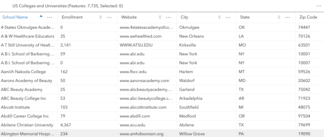
The following image displays the standalone FeatureTable widget
without any associated map.
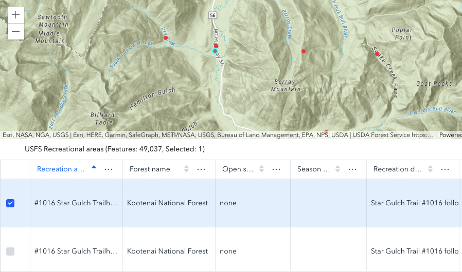
The following image displays the FeatureTable widget with an associated map.
- See also
Constructors
-
Parameterproperties Objectoptional
See the properties for a list of all the properties that may be passed into the constructor.
Example// Typical usage for the FeatureTable widget. This will recognize all fields in the layer if none are set. const featureTable = new FeatureTable({ view: view, // The view property must be set for the select/highlight to work layer: featureLayer, container: "tableDiv" // the table must be assigned to the container via the constructor });
Property Overview
| Name | Type | Summary | Class |
|---|---|---|---|
| Collection<(GeometryFilter|SelectionFilter)> | A read-only property indicating the type of filter used by the table. | FeatureTable | |
| ColumnSortOrder[] | Use this read-only property if needing to query features while retaining a column's sort order. | FeatureTable | |
| Boolean | Indicates whether to display the | FeatureTable | |
| Boolean | Automatically refreshes the table when its associated layer has been updated. | FeatureTable | |
| Boolean | When | FeatureTable | |
| Collection<(FieldColumn|GroupColumn)> | A read-only collection of field columns and/or grouped field columns within the table. | FeatureTable | |
| String|HTMLElement | The ID or node representing the DOM element containing the widget. | FeatureTable | |
| String | The name of the class. | Accessor | |
| Boolean | Indicates whether editing is enabled on the data within the feature table. | FeatureTable | |
| Geometry | Set this property to filter the features displayed in the table. | FeatureTable | |
| Collection<string> | A collection of string field.names that are to remain hidden within the table. | FeatureTable | |
| Boolean | Indicates whether to highlight the associated feature when a row is selected. | FeatureTable | |
| Collection<number> | This property accepts and returns a collection of feature ObjectId's. | FeatureTable | |
| Boolean | Indicates whether to highlight the associated feature when a row is selected. | FeatureTable | |
| String | The unique ID assigned to the widget when the widget is created. | Widget | |
| String | The widget's default label. | FeatureTable | |
| FeatureLayer|SceneLayer|GeoJSONLayer|CSVLayer|WFSLayer|ImageryLayer | The associated FeatureLayer, SceneLayer, GeoJSONLayer, CSVLayer, ImageryLayer, or WFSLayer containing the fields and attributes to display within the widget. | FeatureTable | |
| ButtonMenu | Reference to the FeatureTable's menu. | FeatureTable | |
| ButtonMenuConfig | Set this object to customize the feature table's menu content. | FeatureTable | |
| Boolean | Indicates whether sorting multiple columns is supported within the table. | FeatureTable | |
| Number | The default page size used when displaying features within the table. | FeatureTable | |
| Boolean | Indicates whether to fetch geometries for the corresponding features displayed in the table. | FeatureTable | |
| String | The state of the widget. | FeatureTable | |
| TableTemplate | The associated template used for the feature table. | FeatureTable | |
| String | Dates and times displayed in the widget will be in terms of this time zone. | FeatureTable | |
| MapView|SceneView | FeatureTable | ||
| FeatureTableViewModel | The view model for this widget. | FeatureTable | |
| Boolean | Indicates whether the widget is visible. | Widget | |
| VisibleElements | The visible elements that are displayed within the widget. | FeatureTable |
Property Details
-
activeFilters
PropertyactiveFilters Collection<(GeometryFilter|SelectionFilter)>readonly -
A read-only property indicating the type of filter used by the table. It returns either filters by geometry or selections using a row's ObjectId.
- See also
-
activeSortOrders
PropertyactiveSortOrders ColumnSortOrder[]readonlySince: ArcGIS Maps SDK for JavaScript 4.25FeatureTable since 4.15, activeSortOrders added at 4.25. -
Use this read-only property if needing to query features while retaining a column's sort order. It returns an array of ColumnSortOrder. This contains a column's name and its sort direction. The sort priority is honored in the returned ColumnSortOrder if multiSortEnabled is
truewith a set initialSortPriority.- Default Value:[]
-
attachmentsEnabled
PropertyattachmentsEnabled Boolean -
Indicates whether to display the
Attachmentsfield in the table. This is only applicable if the feature layer supports attachments. Currently, this field only displays the count of attachments per feature.
- Default Value:false
-
autoRefreshEnabled
PropertyautoRefreshEnabled BooleanSince: ArcGIS Maps SDK for JavaScript 4.23FeatureTable since 4.15, autoRefreshEnabled added at 4.23. -
Automatically refreshes the table when its associated layer has been updated.
- Default Value:true
-
columnReorderingEnabled
PropertycolumnReorderingEnabled BooleanSince: ArcGIS Maps SDK for JavaScript 4.16FeatureTable since 4.15, columnReorderingEnabled added at 4.16. -
When
true, columns can be reordered by dragging a column's header.- Default Value:true
-
columns
Propertycolumns Collection<(FieldColumn|GroupColumn)>autocastreadonly -
A read-only collection of field columns and/or grouped field columns within the table.
By default fields such as
CreationDate,Creator,EditDate,Editor, andGlobalIDdo not show. If these fields are needed, set them via TableTemplate.columnTemplates. In this case, it is also required that the column template'svisibleproperty is set totrue.- See also
-
container
Propertycontainer String|HTMLElement -
The ID or node representing the DOM element containing the widget. This property can only be set once. The snippets below provide some examples for setting this.
The FeatureTable widget's container property must be set within its constructor and not via the
view.ui.add()method.Examples// Create the HTML div element programmatically at runtime and set to the widget's container const featureTable = new FeatureTable({ view: view, container: document.createElement("tableDiv") });// Specify an already-defined HTML div element in the widget's container const featureTable = new FeatureTable({ view: view, container: featureTableDiv }); // HTML markup <body> <div id="viewDiv"></div> <div class="container"> <div id="tableDiv"></div> </div> </body>
-
editingEnabled
PropertyeditingEnabled BooleanSince: ArcGIS Maps SDK for JavaScript 4.16FeatureTable since 4.15, editingEnabled added at 4.16. -
Indicates whether editing is enabled on the data within the feature table. Double-clicking in a cell will enable editing for that value.
Editing permissions can be broken down with the following levels of priority:
- Field - This is derived
from the FeatureLayer. It takes what is set in the Field.editable property. This
must always be
truefor editing to be enabled. This can be overridden using a field column template. - Template - The editable permissions on a field can be configured by setting the editable property of the FieldColumnTemplate.
- FeatureTable - The editingEnabled property must be set on the table in order for any type of editing to be enabled.
For example, if table editing is disabled on the widget, i.e.
enableEditingis not set, it is still possible to enable editing for a specific column by setting the FieldColumnTemplate.editable property totrue. In contrast to this, if a table has editing enabled, setting a field column template'seditableproperty tofalsecan disable editing for a specific column.If the service's field is not editable, it is not possible to override its permissions using any of the options above.

- Default Value:false
- See also
- Field - This is derived
from the FeatureLayer. It takes what is set in the Field.editable property. This
must always be
-
Since: ArcGIS Maps SDK for JavaScript 4.19FeatureTable since 4.15, filterGeometry added at 4.19. -
Set this property to filter the features displayed in the table. It accepts a Geometry, e.g. Extent, and uses it as a spatial filter. When modifying this property, the FeatureTable will completely refresh and re-query for all features.
- See also
Example// Listen for when the view is stationary. // If true, check the view's extent and set // the table to display only the attributes // for the features falling within this extent. reactiveUtils.when( () => view.stationary === true, () => { // Get the new extent of view/map whenever map is updated. if (view.extent) { // Filter out and show only the visible features in the feature table. featureTable.filterGeometry = view.extent; } }, { initial: true });
-
hiddenFields
PropertyhiddenFields Collection<string>ArcGIS Maps SDK for JavaScript 4.16FeatureTable since 4.15, hiddenFields added at 4.16. -
A collection of string field.names that are to remain hidden within the table. By default fields such as
CreationDate,Creator,EditDate,Editor, andGlobalIDdo not show. If these fields are needed, set them via TableTemplate.columnTemplates. In this case, it is also required that the column template's visible property is set totrue.- Default Value:true
- See also
Examplesconst featureTable = new FeatureTable({ layer: featureLayer, view: view, hiddenFields: ["Primary_Type", "incident_date"], // will not show these two fields within the table container: document.getElementById("tableDiv") });// Set this syntax if needing to display a default hidden field, e.g. 'CreationDate` const featureTable = new FeatureTable({ layer: featureLayer, view: view, tableTemplate: { // autocastable to TableTemplate columnTemplates: [ // takes an array of FieldColumnTemplate and GroupColumnTemplate { //autocastable to FieldColumnTemplate type: "field", fieldName: "date_created", label: "Date created", visible: true }] } container: document.getElementById("tableDiv") });
-
highlightEnabled
PropertyhighlightEnabled BooleanSince: ArcGIS Maps SDK for JavaScript 4.25FeatureTable since 4.15, highlightEnabled added at 4.25. -
Indicates whether to highlight the associated feature when a row is selected.
- Default Value:true
-
highlightIds
PropertyhighlightIds Collection<number>Since: ArcGIS Maps SDK for JavaScript 4.25FeatureTable since 4.15, highlightIds added at 4.25. -
This property accepts and returns a collection of feature ObjectId's. Use this to access and control which features are currently selected in the table and subsequently highlighted within the map. Once an application sets a collection of ObjectId's, the table will select the corresponding row and highlight its feature within the map.
Example// This example instantiates the table with highlighted features const featureTable = new FeatureTable({ view: view, layer: featureLayer, container: "tableDiv", highlightIds }); // Push the object ids into a collection and select featureTable.highlightIds.push(2, 3, 4); // Listen for changes in the collection of highlighted features featureTable.highlightIds.on("change", (event) => { console.log("features selected", event.added); console.log("features deselected", event.removed); });
-
highlightOnRowSelectEnabled
PropertyhighlightOnRowSelectEnabled BooleanSince: ArcGIS Maps SDK for JavaScript 4.16FeatureTable since 4.15, highlightOnRowSelectEnabled added at 4.16. Deprecated since version 4.25. Use highlightEnabled instead. -
Indicates whether to highlight the associated feature when a row is selected.
- Default Value:true
-
label
Propertylabel String -
The widget's default label.
-
layer
Propertylayer FeatureLayer|SceneLayer|GeoJSONLayer|CSVLayer|WFSLayer|ImageryLayer -
The associated FeatureLayer, SceneLayer, GeoJSONLayer, CSVLayer, ImageryLayer, or WFSLayer containing the fields and attributes to display within the widget. The table's pagination defaults to
50records at a time. If the layer contains less than 50 records, it will use whatever count it has. Note that 0 records do not apply.- Support for GeoJSONLayer, CSVLayer, ImageryLayer, and WFSLayer was added at version 4.21.
- For an ImageryLayer to work with FeatureTable, it must have a mosaic dataset. Currently,
MapandFeatureTableinteraction withImageryLayersare not supported.
- See also
-
menu
Propertymenu ButtonMenureadonlySince: ArcGIS Maps SDK for JavaScript 4.19FeatureTable since 4.15, menu added at 4.19. -
Reference to the FeatureTable's menu.
The menu's items are regenerated when a column's visibility changes. Use the FeatureTable's menuConfig and menuConfig.items to customize menu items. These options are recommended, rather than updating The table's
itemsdirectly off of itsmenu. This helps ensure the menu always shows the correct items.- See also
-
menuConfig
PropertymenuConfig ButtonMenuConfigSince: ArcGIS Maps SDK for JavaScript 4.16FeatureTable since 4.15, menuConfig added at 4.16. -
Set this object to customize the feature table's menu content.
-
multiSortEnabled
PropertymultiSortEnabled BooleanSince: ArcGIS Maps SDK for JavaScript 4.23FeatureTable since 4.15, multiSortEnabled added at 4.23. -
Indicates whether sorting multiple columns is supported within the table. Use this in combination with the FieldColumnTemplate.initialSortPriority and FieldColumnTemplate.direction properties to set sorting functionality for multiple columns.
Exampleconst featureTableVM = new FeatureTableViewModel({ layer: featureLayer, multiSortEnabled: true, tableTemplate: { // autocasts to TableTemplate columnTemplates: [ // takes an array of FieldColumnTemplate and GroupColumnTemplate { // autocasts to FieldColumnTemplate type: "field", fieldName: "ObjectId", direction: "asc", // In order to use initialSortPriority, make sure direction is set initialSortPriority: 1, // This field's sort order takes second-highest priority. }, { type: "field", fieldName: "Name", direction: "asc", // In order to use initialSortPriority, make sure direction is set initialSortPriority: 0, // This field's sort order takes the highest priority. }, { type: "field", fieldName: "Status", direction: "asc", // In order to use initialSortPriority, make sure direction is set initialSortPriority: 2 // This field's sort order is prioritized after Name and ObjectId, respectively. }] }, container: "tableDiv" });
-
pageSize
PropertypageSize NumberSince: ArcGIS Maps SDK for JavaScript 4.19FeatureTable since 4.15, pageSize added at 4.19. -
The default page size used when displaying features within the table. By default, the page loads the first 50 features returned by the service.
It is not possible to overwrite the maximum page size on the server, ie.
maxRecordCount, as this property only applies to set values less than the maximum page size, i.e.maxRecordCount, set on the service.- Default Value:50
- See also
-
returnGeometryEnabled
PropertyreturnGeometryEnabled BooleanSince: ArcGIS Maps SDK for JavaScript 4.27FeatureTable since 4.15, returnGeometryEnabled added at 4.27. -
Indicates whether to fetch geometries for the corresponding features displayed in the table. NOTE: Setting this to true can impact performance of the widget.
- Default Value:false
-
state
Propertystate Stringreadonly -
The state of the widget.
Possible Values:"disabled"|"loading"|"loaded"|"ready"
- Default Value:disabled
-
tableTemplate
PropertytableTemplate TableTemplateSince: ArcGIS Maps SDK for JavaScript 4.24FeatureTable since 4.15, tableTemplate added at 4.24. -
The associated template used for the feature table.
The tableTemplate is where you configure how the feature table should display and set any associated properties for the table and its columns.
Exampleconst tableTemplate = new TableTemplate({ columnTemplates: [ // takes an array of FieldColumnTemplate and GroupColumnTemplate { // autocasts to FieldColumnTemplate type: "field", fieldName: "ObjectId", direction: "asc", // In order to use initialSortPriority, make sure direction is set initialSortPriority: 1 // This field's sort order takes the second-highest priority. }, { type: "field", fieldName: "NAME", label: "Name", direction: "asc", // In order to use initialSortPriority, make sure direction is set initialSortPriority: 0 // This field's sort order takes the highest priority }, { type: "field", fieldName: "STATUS", label: "Status", direction: "asc", // In order to use initialSortPriority, make sure direction is set initialSortPriority: 2 // This field's sort order is prioritized after Name and ObjectId, respectively. }] });
-
timeZone
PropertytimeZone StringSince: ArcGIS Maps SDK for JavaScript 4.28FeatureTable since 4.15, timeZone added at 4.28. -
Dates and times displayed in the widget will be in terms of this time zone. If not supplied, the view's time zone is used (if available). Depending on the field type, individual columns may have their own unique time zone behavior when the time zone itself is
unknown.The following considerations apply when working with date, time, and big integer field types:
- By default, the FeatureTable displays timezones for
dateandtimestamp-offsetfield types reflecting the MapView's timezone. This timezone can be overridden by setting the table's timezone property. - If the table's view isn't set, and the table's esri/widgets/Feature#timeZone timeZone isn't set, the table defaults to
systemtime. The only time that this is not the case is when there is a preferredTimeZone set on the table's layer. If the latter is true, the preferred time zone is used as opposed tosystem.
- By default, the FeatureTable displays timezones for
-
viewModel
PropertyviewModel FeatureTableViewModelautocast -
The view model for this widget. This is a class that contains all the logic, (ie. properties and methods), that controls the widget's behavior. See the FeatureTableViewModel class to access all properties and methods on the widget.
-
visible
InheritedPropertyvisible BooleanInherited from Widget -
Indicates whether the widget is visible.
If
false, the widget will no longer be rendered in the web document. This may affect the layout of other elements or widgets in the document. For example, if this widget is the first of three widgets associated to the upper right hand corner of the view UI, then the other widgets will reposition when this widget is made invisible. For more information, refer to the css display value of"none".- Default Value:true
Example// Hides the widget in the view widget.visible = false;
-
visibleElements
PropertyvisibleElements VisibleElements -
The visible elements that are displayed within the widget. This property provides the ability to turn individual elements of the widget's display on/off.
Example// Default values are displayed below featureTable.visibleElements = { header: true, menu: true, menuItems: { clearSelection: true, deleteSelection: true, // Works if the layer supports deletion and editingEnabled property is true refreshData: true, toggleColumns: true, selectedRecordsShowAllToggle: true, selectedRecordsShowSelectedToggle: true, zoomToSelection: true }, selectionColumn: true, columnMenus: true }
Method Overview
| Name | Return Type | Summary | Class |
|---|---|---|---|
Adds one or more handles which are to be tied to the lifecycle of the object. | Accessor | ||
| String | A utility method used for building the value for a widget's | Widget | |
Clears the current selection within the table. | FeatureTable | ||
Clears the current selection filter within the table. | FeatureTable | ||
| Promise<void> | Deletes all the selected rows from the table. | FeatureTable | |
Unselects the specified rows within the table. | FeatureTable | ||
Destroys the widget instance. | Widget | ||
| Boolean | Emits an event on the instance. | Widget | |
Filters the table by the current selection. | FeatureTable | ||
| Column|GroupColumn | Finds the specified column within the feature table. | FeatureTable | |
| Boolean | Indicates whether there is an event listener on the instance that matches the provided event name. | Widget | |
| Boolean | Returns true if a named group of handles exist. | Accessor | |
Hides the specified column from the feature table. | FeatureTable | ||
| Boolean |
| Widget | |
| Boolean |
| Widget | |
| Boolean |
| Widget | |
| Object | Registers an event handler on the instance. | Widget | |
Adds one or more handles which are to be tied to the lifecycle of the widget. | Widget | ||
This method is primarily used by developers when implementing custom widgets. | Widget | ||
| Promise<void> | Refreshes the table contents while maintaining the current scroll position. | FeatureTable | |
Removes a group of handles owned by the object. | Accessor | ||
| Object | This method is primarily used by developers when implementing custom widgets. | Widget | |
Renders widget to the DOM immediately. | Widget | ||
This method is primarily used by developers when implementing custom widgets. | Widget | ||
Scrolls the table to a row based on a specified index. | FeatureTable | ||
Selects the specified rows within the table. | FeatureTable | ||
Shows all of the columns in the table. | FeatureTable | ||
Shows the specified column within the feature table. | FeatureTable | ||
Sorts the column in either ascending ("asc") or descending ("desc") order. | FeatureTable | ||
| Promise |
| Widget | |
Zooms the view to the extent of the current row selection. | FeatureTable |
Method Details
-
Inherited from Accessor
Since: ArcGIS Maps SDK for JavaScript 4.25Accessor since 4.0, addHandles added at 4.25. -
Adds one or more handles which are to be tied to the lifecycle of the object. The handles will be removed when the object is destroyed.
// Manually manage handles const handle = reactiveUtils.when( () => !view.updating, () => { wkidSelect.disabled = false; }, { once: true } ); this.addHandles(handle); // Destroy the object this.destroy();ParametershandleOrHandles WatchHandle|WatchHandle[]Handles marked for removal once the object is destroyed.
groupKey *optionalKey identifying the group to which the handles should be added. All the handles in the group can later be removed with Accessor.removeHandles(). If no key is provided the handles are added to a default group.
-
classes
InheritedMethodclasses(classNames){String}Inherited from Widget -
A utility method used for building the value for a widget's
classproperty. This aids in simplifying css class setup.ReturnsType Description String The computed class name. Example// .tsx syntax showing how to set css classes while rendering the widget render() { const dynamicIconClasses = { [css.myIcon]: this.showIcon, [css.greyIcon]: !this.showIcon }; return ( <div class={classes(css.root, css.mixin, dynamicIconClasses)} /> ); }
-
Since: ArcGIS Maps SDK for JavaScript 4.16FeatureTable since 4.15, clearSelection added at 4.16. Deprecated since version 4.25. Use highlightIds.removeAll() instead. -
Clears the current selection within the table.
-
Since: ArcGIS Maps SDK for JavaScript 4.23FeatureTable since 4.15, clearSelectionFilter added at 4.23. -
Clears the current selection filter within the table.
-
deleteSelection
MethoddeleteSelection(showWarningPrompt){Promise<void>}Since: ArcGIS Maps SDK for JavaScript 4.25FeatureTable since 4.15, deleteSelection added at 4.25. -
Deletes all the selected rows from the table.
There must be at least one selected row within the table for this to work. Also, make sure that editingEnabled is set to
trueand the underlying service data supports deletion.ParametershowWarningPrompt BooleanoptionalIndicates whether to display a prompt warning that the selected features will be deleted. Default behavior is to show a warning dialog before proceeding.
ReturnsType Description Promise<void> Resolves when the selection is deleted.
-
Since: ArcGIS Maps SDK for JavaScript 4.16FeatureTable since 4.15, deselectRows added at 4.16. Deprecated since 4.25. Use highlightIds.remove() instead. -
Unselects the specified rows within the table.
ParameterThe selection parameters to deselect within the feature table.
-
Inherited from Widget
-
Destroys the widget instance.
-
Since: ArcGIS Maps SDK for JavaScript 4.16FeatureTable since 4.15, filterBySelection added at 4.16. -
Filters the table by the current selection.
-
findColumn
MethodfindColumn(fieldName){Column|GroupColumn}Since: ArcGIS Maps SDK for JavaScript 4.16FeatureTable since 4.15, findColumn added at 4.16. -
Finds the specified column within the feature table.
ParameterfieldName StringThe
fieldNameof the column to find.ReturnsType Description Column | GroupColumn The returned column.
-
hasEventListener
InheritedMethodhasEventListener(type){Boolean}Inherited from Widget -
Indicates whether there is an event listener on the instance that matches the provided event name.
Parametertype StringThe name of the event.
ReturnsType Description Boolean Returns true if the class supports the input event.
-
hasHandles
InheritedMethodhasHandles(groupKey){Boolean}Inherited from AccessorSince: ArcGIS Maps SDK for JavaScript 4.25Accessor since 4.0, hasHandles added at 4.25. -
Returns true if a named group of handles exist.
ParametergroupKey *optionalA group key.
ReturnsType Description Boolean Returns trueif a named group of handles exist.Example// Remove a named group of handles if they exist. if (obj.hasHandles("watch-view-updates")) { obj.removeHandles("watch-view-updates"); }
-
Since: ArcGIS Maps SDK for JavaScript 4.16FeatureTable since 4.15, hideColumn added at 4.16. -
Hides the specified column from the feature table.
ParameterfieldName StringThe
fieldNameof the column to hide.
-
isFulfilled
InheritedMethodisFulfilled(){Boolean}Inherited from WidgetSince: ArcGIS Maps SDK for JavaScript 4.19Widget since 4.2, isFulfilled added at 4.19. -
isFulfilled()may be used to verify if creating an instance of the class is fulfilled (either resolved or rejected). If it is fulfilled,truewill be returned.ReturnsType Description Boolean Indicates whether creating an instance of the class has been fulfilled (either resolved or rejected).
-
isRejected
InheritedMethodisRejected(){Boolean}Inherited from WidgetSince: ArcGIS Maps SDK for JavaScript 4.19Widget since 4.2, isRejected added at 4.19. -
isRejected()may be used to verify if creating an instance of the class is rejected. If it is rejected,truewill be returned.ReturnsType Description Boolean Indicates whether creating an instance of the class has been rejected.
-
isResolved
InheritedMethodisResolved(){Boolean}Inherited from WidgetSince: ArcGIS Maps SDK for JavaScript 4.19Widget since 4.2, isResolved added at 4.19. -
isResolved()may be used to verify if creating an instance of the class is resolved. If it is resolved,truewill be returned.ReturnsType Description Boolean Indicates whether creating an instance of the class has been resolved.
-
on
InheritedMethodon(type, listener){Object}Inherited from Widget -
Registers an event handler on the instance. Call this method to hook an event with a listener.
ParametersAn event or an array of events to listen for.
listener FunctionThe function to call when the event fires.
ReturnsType Description Object Returns an event handler with a remove()method that should be called to stop listening for the event(s).Property Type Description remove Function When called, removes the listener from the event. Exampleview.on("click", function(event){ // event is the event handle returned after the event fires. console.log(event.mapPoint); });
-
Inherited from Widget
Since: ArcGIS Maps SDK for JavaScript 4.24Widget since 4.2, own added at 4.24. Deprecated since 4.28 Use addHandles() instead. -
Adds one or more handles which are to be tied to the lifecycle of the widget. The handles will be removed when the widget is destroyed.
const handle = reactiveUtils.when( () => !view.updating, () => { wkidSelect.disabled = false; }, { once: true} ); this.own(handle); // Handle gets removed when the widget is destroyed.ParameterhandleOrHandles WatchHandle|WatchHandle[]Handles marked for removal once the widget is destroyed.
-
Inherited from Widget
-
This method is primarily used by developers when implementing custom widgets. Executes after widget is ready for rendering.
-
Inherited from Accessor
Since: ArcGIS Maps SDK for JavaScript 4.25Accessor since 4.0, removeHandles added at 4.25. -
Removes a group of handles owned by the object.
ParametergroupKey *optionalA group key or an array or collection of group keys to remove.
Exampleobj.removeHandles(); // removes handles from default group obj.removeHandles("handle-group"); obj.removeHandles("other-handle-group");
-
Inherited from Widget
-
Renders widget to the DOM immediately.
-
Inherited from Widget
-
This method is primarily used by developers when implementing custom widgets. Schedules widget rendering. This method is useful for changes affecting the UI.
-
Since: ArcGIS Maps SDK for JavaScript 4.19FeatureTable since 4.15, scrollToIndex added at 4.19. -
Scrolls the table to a row based on a specified index.
Parameterindex NumberIndex of the row in which the table should scroll.
-
Since: ArcGIS Maps SDK for JavaScript 4.16FeatureTable since 4.15, selectRows added at 4.16. Deprecated since 4.25. Use highlightIds.add() instead. -
Selects the specified rows within the table.
ParameterThe selection parameters to select within the feature table.
-
Since: ArcGIS Maps SDK for JavaScript 4.16FeatureTable since 4.15, showAllColumns added at 4.16. -
Shows all of the columns in the table.
-
Since: ArcGIS Maps SDK for JavaScript 4.16FeatureTable since 4.15, showColumn added at 4.16. -
Shows the specified column within the feature table.
ParameterfieldName StringThe
fieldNameof the column to show.
-
when
InheritedMethodwhen(callback, errback){Promise}Inherited from WidgetSince: ArcGIS Maps SDK for JavaScript 4.19Widget since 4.2, when added at 4.19. -
when()may be leveraged once an instance of the class is created. This method takes two input parameters: acallbackfunction and anerrbackfunction. Thecallbackexecutes when the instance of the class loads. Theerrbackexecutes if the instance of the class fails to load.Parameterscallback FunctionoptionalThe function to call when the promise resolves.
errback FunctionoptionalThe function to execute when the promise fails.
ReturnsExample// Although this example uses the BasemapGallery widget, any class instance that is a promise may use when() in the same way let bmGallery = new BasemapGallery(); bmGallery.when(function(){ // This function will execute once the promise is resolved }, function(error){ // This function will execute if the promise is rejected due to an error });
-
Since: ArcGIS Maps SDK for JavaScript 4.23FeatureTable since 4.15, zoomToSelection added at 4.23. -
Zooms the view to the extent of the current row selection. This can also be triggered as a menu item within the table. This item will display if at least one row is selected and the view is set on the
FeatureTable.
Type Definitions
-
The configurable options to customize either the feature table or column menu via the menuConfig property.
- Properties
-
optionalcontainer HTMLElement
The DOM Element containing the menu.
optionaliconClass StringAdds a CSS class to the menu button's DOM node.
optionalitems ButtonMenuItem[]An array of ButtonMenuItems.
optionalopen BooleanIndicates if the menu content is visible. Default is
false.optionalviewModel ButtonMenuViewModelThe associated viewModel for the ButtonMenu.
- See also
-
The configurable options to customize either the feature table or column menu via the menuConfig item property.
- Properties
-
optionalautoCloseMenu Boolean
Indicates whether to automatically close the menu's item.
optionalclickFunction ButtonMenuItemClickFunctionA function that executes on the ButtonMenuItem's
clickevent.optionaliconClass StringAdds a CSS class to the menu button's DOM node.
optionalitems ButtonMenuItem[]An array of individual menu items.
optionallabel StringThe label of the menu item. This can be used in conjunction with the iconClass property.
optionalopen BooleanIndicates if the menu content is visible.
optionalselectionEnabled BooleanIndicates whether a toggled state should be applied to individual menu items.
optionalselected BooleanIndicates whether the menu item is selected.
- See also
-
The visible elements that are displayed within the widget. This provides the ability to turn individual elements of the widget's display on/off.
- Properties
-
optionalheader Boolean
Indicates whether to display the feature table's header information. Default value is
true.optionalmenu BooleanIndicates whether to display the feature table's menu. Default value is
true.optionalselectionColumn BooleanIndicates whether to display the selection column in the table. Each row has a checkbox that selects its corresponding feature. Default value is
true. If working with a map, make certain to set theFeatureTable.viewproperty as this enables highlighting the corresponding feature.optionalcolumnMenus Boolean(Since 4.23) Indicates whether to display the menu items within the individual columns. Default value is
true.optionalmenuItems ObjectThe menu items within the feature table menu.
- Specification
-
optionalclearSelection Boolean
Indicates whether to display the
Clear selectionmenu item. Default value istrueand will display within the menu if any rows are selected.optionaldeleteSelection Boolean(Since 4.25) Indicates whether to display the
Delete Selectionmenu item. Default value istrueand will display ifeditingEnabledistrueand enabled on the feature service and rows are selected.optionalrefreshData BooleanIndicates whether to display the
Refresh datamenu item. Default value istrue.optionalselectedRecordsShowAllToggle Boolean(Since 4.23) Indicates whether to toggle between showing only selected records in the table to showing all of the records. Default value is
true.optionalselectedRecordsShowSelectedToggle Boolean(Since 4.23) Indicates whether to display the
Show selected recordsmenu item. Default value istrueand will display within the menu if any rows are selected.optionaltoggleColumns toggleColumnsIndicates whether to enable toggling column visibility within the menu. Default value is
true.optionalzoomToSelection zoomToSelection(Since 4.23) Indicates whether to display the
Zoom to selectedmenu item. Default value istrueand will display within the menu if any rows are selected.
Event Overview
| Name | Type | Summary | Class |
|---|---|---|---|
| {added: Object[],added.feature: Graphic,added.attachments: AttachmentInfo[],added.objectId: Number,added.relatedRecords: Graphic[],removed: Object[],removed.feature: Graphic,removed.attachments: AttachmentInfo[],removed.objectId: Number,removed.relatedRecords: Graphic[]} |
Fires when a row selection is added and/or removed within the FeatureTable. |
FeatureTable |
Event Details
-
Deprecated since version 4.25. Listen for changes on highlightIds instead.
-
Fires when a row selection is added and/or removed within the FeatureTable. This functionality can also be achieved by listening for changes on the highlightIds collection.
- Properties
-
An array of objects containing row (feature) data added to the table selection.
- Specification
-
feature Graphic
The associated row (feature) added to the feature table selection.
attachments AttachmentInfo[]If applicable, an array of AttachmentInfo associated with the row (feature) added to the feature table selection.
objectId NumberThe objectId associated with the added item.
(Currently not implemented). If applicable, an array of related features associated with the row (feature) added to the feature table selection.
An array of objects containing row (feature) data removed in the table selection.
- Specification
-
feature Graphic
The associated row (feature) removed from the feature table selection.
attachments AttachmentInfo[]If applicable, an array of AttachmentInfo associated with the row (feature) removed from the feature table selection.
objectId NumberThe objectId associated with the removed item.
(Currently not implemented). If applicable, an array of related features associated with the row (feature) removed from the feature table selection.
Example// This function will fire each time a row (feature) is either added // or removed from the feature table's selection featureTable.on("selection-change", (event) => { let addedRows = event.added; // An array of features added to the selection let removedRows = event.removed; // An array of features removed from the selection });