These functions help you use elevation analysis
profile
-
arcgis.features.elevation.profile(input_line_features={'displayFieldName': '', 'exceededTransferLimit': False, 'features': [], 'fields': [{'name': 'OID', 'type': 'esriFieldTypeOID', 'alias': 'OID'}, {'name': 'Shape_Length', 'type': 'esriFieldTypeDouble', 'alias': 'Shape_Length'}], 'geometryType': 'esriGeometryPolyline', 'spatialReference': {'latestWkid': 3857, 'wkid': 102100}}, profile_id_field=None, dem_resolution=None, maximum_sample_distance=None, maximum_sample_distance_units='Meters', gis=None, future=False)¶ 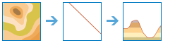
The profile method is used to create profiles along input lines from which a profile graph can be created.
In asynchronous mode, the maximum number of input line features that can be accepted by the task for each request is 1000.
Parameter
Description
input_line_features
Required featureset. The line features that will be profiled over the surface.
profile_id_field
Optional string. A unique identifier to tie profiles to their corresponding input line features.
dem_resolution
Optional string. The approximate spatial resolution (cell size) of the source elevation data used for the calculation. The resolution values are an approximation of the spatial resolution of the digital elevation model. While many elevation sources are distributed in units of arc seconds, the keyword is an approximation of those resolutions in meters for easier understanding.
maximum_sample_distance
Optional float. The maximum sampling distance along the line to sample elevation values.
maximum_sample_distance_units
Optional string. The units for the MaximumSampleDistance.
Choice list:[‘Meters’, ‘Kilometers’, ‘Feet’, ‘Yards’, ‘Miles’]
future
Optional boolean. If True, the result will be a GPJob and results will be returned asynchronously.
- Returns
Output Profile as a FeatureSet
USAGE EXAMPLE: To create profile of mountains feature.
elevation = profile(input_line_features=mountain_fs,
                    dem_resolution='FINEST',
                    maximum_sample_distance=500,
                    maximum_sample_distance_units='Meters')
viewshed
-
arcgis.features.elevation.viewshed(input_points={'displayFieldName': '', 'exceededTransferLimit': False, 'features': [], 'fields': [{'name': 'OID', 'type': 'esriFieldTypeOID', 'alias': 'OID'}, {'name': 'offseta', 'type': 'esriFieldTypeDouble', 'alias': 'offseta'}, {'name': 'offsetb', 'type': 'esriFieldTypeDouble', 'alias': 'offsetb'}], 'geometryType': 'esriGeometryPoint', 'spatialReference': {'latestWkid': 3857, 'wkid': 102100}}, maximum_distance=None, maximum_distance_units='Meters', dem_resolution=None, observer_height=None, observer_height_units='Meters', surface_offset=None, surface_offset_units='Meters', generalize_viewshed_polygons=True, gis=None, future=False)¶ 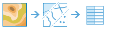
The
viewshedmethod is used to identify visible areas based on observer locations you provide as well as ArcGIS Online Elevation data.Parameter
Description
input_points
Required FeatureSet. The point features to use as the observer locations. See Feature Input.
maximum_distance
Optional float. This is a cutoff distance where the computation of visible areas stops. Beyond this distance, it is unknown whether the analysis points and the other objects can see each other.
It is useful for modeling current weather conditions or a given time of day, such as dusk. Large values increase computation time.
Unless specified, a default maximum distance will be computed based on the resolution and extent of the source DEM. The allowed maximum value is 50 kilometers.
Use
maximum_distance_unitsto set the units formaximum_distance.maximum_distance_units
Optional string. The units for the
maximum_distanceparameter.Choice list:[‘Meters’, ‘Kilometers’, ‘Feet’, ‘Yards’, ‘Miles’].
The default is ‘Meters’.
dem_resolution
Optional string. The approximate spatial resolution (cell size) of the source elevation data used for the calculation. The resolution values are an approximation of the spatial resolution of the digital elevation model. While many elevation sources are distributed in units of arc seconds, the keyword is an approximation of those resolutions in meters for easier understanding.
Choice list:[‘ ‘, ‘FINEST’, ‘10m’, ‘30m’, ‘90m’].
The default is 90m.
observer_height
Optional float. This is the height above the ground of the observer locations.
The default is 1.75 meters, which is approximately the average height of a person. If you are looking from an elevated location, such as an observation tower or a tall building, use that height instead.
Use
observer_height_unitsto set the units forobserver_height.observer_height_units
Optional string. The units for the
observer_heightparameter.Choice list:[‘Meters’, ‘Kilometers’, ‘Feet’, ‘Yards’, ‘Miles’]
surface_offset
Optional float. The height above the surface of the object you are trying to see.
The default value is 0.0. If you are trying to see buildings or wind turbines, use their height here.
surface_offset_units
Optional string. The units for the
surface_offsetparameter.Choice list:[‘Meters’, ‘Kilometers’, ‘Feet’, ‘Yards’, ‘Miles’]
generalize_viewshed_polygons
Optional boolean. Determines whether or not the viewshed polygons are to be generalized.
The viewshed calculation is based on a raster elevation model that creates a result with stair-stepped edges. To create a more pleasing appearance and improve performance, the default behavior is to generalize the polygons. The generalization process smooths the boundary of the visible areas and may remove some single-cell visible areas.
future
Optional boolean. If True, the result will be a GPJob and results will be returned asynchronously.
- Returns
output_viewshed - Output Viewshed as a FeatureSet (polygons of visible areas for a given set of input observation points.)
# USAGE EXAMPLE: To identify visible areas from esri headquarter office.
visible_windfarms = viewshed(input_points=hq_fs,
                             maximum_distance=200,
                             maximum_distance_units='Meters',
                             observer_height=6,
                             observer_height_units='Feet',
                             surface_offset=100,
                             surface_offset_units='Meters',
                             generalize_viewshed_polygons=True)
summarize_elevation
-
arcgis.features.elevation.summarize_elevation(input_features={}, feature_id_field=None, dem_resolution=None, include_slope_aspect=False, gis=None, future=False)¶ 
The
summarize_elevationmethod calculates summary statistics for features you provide based on ArcGIS Online Elevation data. It accepts point, line, or polygon input and returns statistics for the elevation, slope, and aspect of the features.Parameter
Description
input_features
Reqauired FeatureSet. Input features to summarize the elevation for. The features can be point, line, or area. See Feature Input.
feature_id_field
Optional string. The unique ID field to use for the input features.
dem_resolution
Optional string. The approximate spatial resolution (cell size) of the source elevation data used for the calculation.
Choice list:[‘ ‘, ‘FINEST’, ‘10m’, ‘30m’, ‘90m’]
The default value is None.
include_slope_aspect
Optional boolean. Determines if slope and aspect for the input feature(s) will be included in the output. The slope and aspect values in the output are in degrees.
The default value is False.
future
Optional boolean. If True, the result will be a GPJob and results will be returned asynchronously.
- Returns
result_layer : Output Summary as a FeatureSet
# USAGE EXAMPLE: To calculate summary statistics for mountain polyline features.
summarize = summarize_elevation(input_features=mountain_fs,
                   dem_resolution='FINEST',
                   include_slope_aspect=True)