Class GeometryBagClass
[Guid("10B5F5C0-3781-11D2-BCC5-0000F875BCCE")]
[ClassInterface(ClassInterfaceType.None)]
public class GeometryBagClass : GeometryBag, IGeometry5, IGeometry4, IGeometry3, IGeometry2, IGeometryBag, IGeometry, IRelationalOperator, ITopologicalOperator, IGeometryCollection, IEnumGeometry, IConstructGeometryCollection, ISupportErrorInfo, IClone, IPersistStream, IPersist, ITransform2D, ISpatialIndex, IXMLVersionSupport, IXMLSerialize- Inheritance
-
GeometryBagClass
- Implements
- Inherited Members
Constructors
GeometryBagClass()
public GeometryBagClass()Explicit Interface Implementations
AddGeometries(int, ref IGeometry)
Adds references to the specified geometries. This method is intended for internal use only.
virtual void AddGeometries(int Count, ref IGeometry newGeometries)Parameters
Remarks
The geometries are added last in the list. Use an array of geometries (IGeometry) and the exact number (count ) of elements in the array. Exceeding the boundary of the array will cause an application error. If you don't want to place the geometries last in the collection then use the InsertGeometries method.
When using C# you must use the IGeometryBridge interface to call this method.
When using VBNET you must use the IGeometryBridge interface to call this method.
AddGeometry(IGeometry, ref object, ref object)
Adds a reference to the input geometry either at the end, or before, or after the specified index.
virtual void AddGeometry(IGeometry inGeometry, ref object before, ref object after)Parameters
Remarks
When applying the AddGeometry method give either the before or after index and not both. Adding a Geometry to the collection as the first one is done by setting the before index as 0.
The spatial reference of the GeometryCollection is transferred
(objects projected if necessary) to any objects added to
it. However the spatial reference of the added geometry is not
transferred to the GeometryCollection. Always make sure to set
the spatial reference on the object GeometryCollection prior to add
other geometries to it to avoid creating invalid geometry. For
example, adding geometry objects to a GeometryBag that doesn't have
a well-defined spatial reference will set an undefined spatial
reference to all the objects added to the bag. Using this
GeometryBag may cause unexpected behavior with the
ITopologicalOperator::ConstructUnion method.
IPoint pnt = new PointClass();
pnt.PutCoords(x, y);
IGeometryCollection geomColl = new MultipointClass() as IGeometryCollection;
object obj = Type.Missing;
geomColl.AddGeometry(pnt, ref obj, ref obj);
AddGeometryCollection(IGeometryCollection)
Adds references to geometries in the input collection.
virtual void AddGeometryCollection(IGeometryCollection newGeometries)Parameters
newGeometriesIGeometryCollection
AllowIndexing
Indicates whether to allow a spatial index to be created for this geometry.
virtual bool AllowIndexing { get; set; }Returns
Remarks
The SpatialIndex if enabled is used by the IRelationalOperator's methods.
Assign(IClone)
Assigns the properties of src to the receiver.
virtual void Assign(IClone src)Parameters
srcIClone
Boundary
The boundary of this geometry. A polygon's boundary is a polyline. A polyline's boundary is a multipoint. A point or multipoint's boundary is an empty point or multipoint.
virtual IGeometry Boundary { get; }Returns
Remarks
ITopologicalOperator methods must be applied on high-level geometries only. High-Level geometries are point, multipoint, polyline and polygon. To use this method with low-level geometries such as segments (Line, Circular Arc, Elliptic Arc, Bézier Curve), paths or rings, they must be wrapped into high-level geometries types.
This method does not support GeometryBags.

//The following code shows to wrap a line segment into a polyline in C#
//Assume a line (line1 as ILine) is already created
object obj = Type.Missing;
ISegmentCollection segCollection = new PolylineClass() as ISegmentCollection;
segCollection.AddSegment((ISegment)line1, ref obj, ref obj);
//Set the spatial reference on the new polyline
//The spatial reference is not transfered automatically from the segments
IGeometry geom = segCollection as IGeometry;
geom.SpatialReference = spatialRef;
//Can now be used with ITopologicalOperator methods
Buffer(double)
Constructs a polygon that is the locus of points at a distance less than or equal to a specified distance from this geometry.
virtual IGeometry Buffer(double distance)Parameters
distancedouble
Returns
Remarks
The buffer distance is in the same units as the source shape that
is being buffered.
A negative distance can be specified to produce a buffer inside the original polygon. This cannot be used with polyline.
ITopologicalOperator methods must be applied on top-level geometries only. Top-Level geometries are point, multipoint, polyline and polygon. To use this method with segments (Line, Circular Arc, Elliptic Arc, Bézier Curve), paths or rings, they must be wrapped with a top-level type.
A buffer distance of 0 will generate an empty polygon with the input geometry being a polyline and multipoint. However, if the input geometry is a point, the output will be the original point.

//The following code shows to wrap a line segment into a polyline in C#
//Assume a line (line1 as ILine) is already created
object obj = Type.Missing;
ISegmentCollection segCollection = new PolylineClass() as ISegmentCollection;
segCollection.AddSegment((ISegment)line1, ref obj, ref obj);
//Set the spatial reference on the new polyline
//The spatial reference is not transfered automatically from the segments
IGeometry geom = segCollection as IGeometry;
geom.SpatialReference = spatialRef;
//Can now be used with ITopologicalOperator methods
[C#]//This example demonstrates how to use
ITopologicalOperator::Buffer
private void BufferArea()
{
IPoint[] points = new IPoint[5];
//The spatial reference should be set here using
IGeometry::SpatialReference (Code skipped here)
for(int i = 0; i < points.Length; i++)
{
points[i] = new PointClass();
}
points[0].PutCoords(0, 0);
points[1].PutCoords(0, 10);
points[2].PutCoords(10, 10);
points[3].PutCoords(10, 0);
points[4].PutCoords(0, 0);
IPointCollection4 pointCollection = new PolygonClass();
IGeometryBridge geometryBride = new
GeometryEnvironmentClass();
geometryBride.AddPoints(pointCollection, ref points);
IArea area = pointCollection as IArea;
System.Windows.Forms.MessageBox.Show("Area original polygon
: " + area.Area);
ITopologicalOperator topologicalOperator = pointCollection
as ITopologicalOperator;
//Outside buffer
IPolygon polygon = topologicalOperator.Buffer(1) as
IPolygon;
area = polygon as IArea;
System.Windows.Forms.MessageBox.Show( "Area polygon positive
distance : " + area.Area);
//Inside buffer
polygon = topologicalOperator.Buffer(-1) as IPolygon;
area = polygon as IArea;
System.Windows.Forms.MessageBox.Show("Area polygon negative
distance : " + area.Area);
}
Sub exampleITopologicalOperator_Buffer()
Dim ptc As
ESRI.ArcGIS.Geometry.IPointCollection, i As Long, pa As
ESRI.ArcGIS.Geometry.IArea, ptopo As
ESRI.ArcGIS.Geometry.ITopologicalOperator
ptc = New
ESRI.ArcGIS.Geometry.Polygon
Dim pt(4) As
ESRI.ArcGIS.Geometry.IPoint, poutPoly As
ESRI.ArcGIS.Geometry.IPolygon
'The spatial reference
should be set here using IGeometry::SpatialReference (Code skipped
here)
For i = 0 To 4
pt(i) = New ESRI.ArcGIS.Geometry.Point
Next
pt(0).PutCoords(0,
0)
pt(1).PutCoords(0,
10)
pt(2).PutCoords(10,
10)
pt(3).PutCoords(10,
0)
pt(4).PutCoords(0,
0)
Dim geometryBride As
ESRI.ArcGIS.Geometry.IGeometryBridge
geometryBride = New
ESRI.ArcGIS.Geometry.GeometryEnvironmentClass()
geometryBride.AddPoints(ptc, pt)
pa = ptc
Debug.Print("Area
original polygon : " & pa.Area)
ptopo = ptc
poutPoly =
ptopo.Buffer(1) 'Outside buffer
pa = poutPoly
Debug.Print("Area
polygon positive distance : " & pa.Area)
poutPoly =
ptopo.Buffer(-1) 'Inside buffer
pa = poutPoly
Debug.Print("Area
polygon negative distance : " & pa.Area)
End Sub
CentroidEx
The center of gravity (centroid).
virtual IPoint CentroidEx { get; }Returns
Changed
Indicates if a geometry has been changed (edited, projected, etc).
virtual bool Changed { get; set; }Returns
Clip(IEnvelope)
Constructs the intersection of this geometry and the specified envelope.
virtual void Clip(IEnvelope clipperEnvelope)Parameters
clipperEnvelopeIEnvelope
Remarks
Use QueryClipped or QueryClippedDense methods to send the results to a different polygon.
ITopologicalOperator methods must be applied on high-level
geometries only. High-Level geometries are point, multipoint,
polyline and polygon. To use this method with
low-level geometries such as segments (Line, Circular Arc, Elliptic
Arc, Bézier Curve), paths or rings, they must be wrapped
into high-level geometries types.

//The following code shows to wrap a line segment into a polyline in C#
//Assume a line (line1 as ILine) is already created
object obj = Type.Missing;
ISegmentCollection segCollection = new PolylineClass() as ISegmentCollection;
segCollection.AddSegment((ISegment)line1, ref obj, ref obj);
//Set the spatial reference on the new polyline
//The spatial reference is not transfered automatically from the segments
IGeometry geom = segCollection as IGeometry;
geom.SpatialReference = spatialRef;
//Can now be used with ITopologicalOperator methods
ClipDense(IEnvelope, double)
Constructs the intersection of this geometry and the specified envelope; densifies lines in output contributed by the clipping envelope.
virtual void ClipDense(IEnvelope clipperEnvelope, double denseDistance)Parameters
Remarks
ITopologicalOperator methods must be applied on high-level geometries only. High-Level geometries are point, multipoint, polyline and polygon. To use this method with low-level geometries such as segments (Line, Circular Arc, Elliptic Arc, Bézier Curve), paths or rings, they must be wrapped into high-level geometries types.
This method does not support GeometryBags.
Clone()
Clones the receiver and assigns the result to *clone.
virtual IClone Clone()Returns
ConstructDivideEqual(IPolyline, int, esriConstructDivideEnum)
Locates additional points equally spaced along the input polyline, and create either new segments, parts or polylines depending on the value of divideHow.
virtual void ConstructDivideEqual(IPolyline divideSource, int numDivisions, esriConstructDivideEnum divideHow)Parameters
divideSourceIPolylinenumDivisionsintdivideHowesriConstructDivideEnum
ConstructDivideLength(IPolyline, double, bool, esriConstructDivideEnum)
Locates additional points along the input polyline, spaced at a specified interval, and create either new segments, parts, or polylines depending on the value of divideHow.
virtual void ConstructDivideLength(IPolyline divideSource, double Length, bool asRatio, esriConstructDivideEnum divideHow)Parameters
divideSourceIPolylineLengthdoubleasRatiobooldivideHowesriConstructDivideEnum
ConstructUnion(IEnumGeometry)
Defines this geometry to be the union of the inputs. More efficient for unioning multiple geometries than calling Union repeatedly.
virtual void ConstructUnion(IEnumGeometry geometries)Parameters
geometriesIEnumGeometry
Remarks
ITopologicalOperator methods must be applied on high-level geometries only. High-Level geometries are point, multipoint, polyline and polygon. To use this method with low-level geometries such as segments (Line, Circular Arc, Elliptic Arc, Bézier Curve), paths or rings, they must be wrapped into high-level geometries types.
This method does not support GeometryBags.
Temproray files might be created. If environment variable
"ARCTMPDIR" exists, then the files are written to the path,
otherwise written to current directory or system temp
directory.
//The following code shows to wrap a line segment into a polyline in C#
//Assume a line (line1 as ILine) is already created
object obj = Type.Missing;
ISegmentCollection segCollection = new PolylineClass() as ISegmentCollection;
segCollection.AddSegment((ISegment)line1, ref obj, ref obj);
//Set the spatial reference on the new polyline
//The spatial reference is not transfered automatically from the segments
IGeometry geom = segCollection as IGeometry;
geom.SpatialReference = spatialRef;
//Can now be used with ITopologicalOperator methods
Contains(IGeometry)
Indicates if this geometry contains the other geometry.
virtual bool Contains(IGeometry other)Parameters
otherIGeometry
Returns
Remarks
Only geometries that support the IRelationalOperator interface can be used as input geometries.
If geometry1 Contains geometry2, then geometry2 is Within geometry1.
An empty geometry does not contain another geometry. On the other hand, an empty geometry is contained in another geometry, unless the other geometry is empty.
Contains examples. Only "true" relationships are showed in this picture.

ConvexHull()
Constructs the convex hull of this geometry.
virtual IGeometry ConvexHull()Returns
Remarks
ITopologicalOperator methods must be applied on high-level geometries only. High-Level geometries are point, multipoint, polyline and polygon. To use this method with low-level geometries such as segments (Line, Circular Arc, Elliptic Arc, Bézier Curve), paths or rings, they must be wrapped into high-level geometries types.
This method does not support GeometryBags.
ConvexHull method does not deal with Z attribute now.

Count
The number of geometries in the enumeration.
virtual int Count { get; }Returns
Crosses(IGeometry)
Indicates if the two geometries intersect in a geometry of lesser dimension.
virtual bool Crosses(IGeometry other)Parameters
otherIGeometry
Returns
Remarks
Only geometries that support the IRelationalOperator interface can be used as input geometries.
Cross only applies to polyline/polyline, polyline/polygon, or polygon/polyline relations.
If either one of the geometries is empty, the geometries do not cross.
Crosses examples. Only "true" relationships are showed in this picture.

Cut(IPolyline, out IGeometry, out IGeometry)
Splits this geometry into a part left of the cutting polyline, and a part right of it.
virtual void Cut(IPolyline cutter, out IGeometry leftGeom, out IGeometry rightGeom)Parameters
Remarks
ITopologicalOperator methods must be applied on high-level geometries only. High-Level geometries are point, multipoint, polyline and polygon. To use this method with low-level geometries such as segments (Line, Circular Arc, Elliptic Arc, Bézier Curve), paths or rings, they must be wrapped into high-level geometries types.
When a polyline/polygon is cut, it is split where it intersects the cutter polyline. Each piece is classified as ‘left of’ or ‘right of’ the cutter. This classification is based on the orientation of the cutter line. Parts of the target polyline that do not intersect the cutting polyline are returned as part of the ‘right of’ result for that input polyline. If a geometry is not cut, the left geometry will be empty.
When using a multi-part polyline to cut a single ring of a polyline, the orientation of the polyline paths is important. The cut piece of the ring must be on the same side of each cutting path as defined by the orientation of each path.
This method does not support GeometryBags.

//The following code shows to wrap a line segment into a polyline in C#
//Assume a line (line1 as ILine) is already created
object obj = Type.Missing;
ISegmentCollection segCollection = new PolylineClass() as ISegmentCollection;
segCollection.AddSegment((ISegment)line1, ref obj, ref obj);
//Set the spatial reference on the new polyline
//The spatial reference is not transfered automatically from the segments
IGeometry geom = segCollection as IGeometry;
geom.SpatialReference = spatialRef;
//Can now be used with ITopologicalOperator methods
Deserialize(IXMLSerializeData)
Deserializes an object from XML.
virtual void Deserialize(IXMLSerializeData data)Parameters
dataIXMLSerializeData
Difference(IGeometry)
Constructs the geometry containing points from this geometry but not the other geometry.
virtual IGeometry Difference(IGeometry other)Parameters
otherIGeometry
Returns
Remarks
ITopologicalOperator methods must be applied on high-level geometries only. High-Level geometries are point, multipoint, polyline and polygon. To use this method with low-level geometries such as segments (Line, Circular Arc, Elliptic Arc, Bézier Curve), paths or rings, they must be wrapped into high-level geometries types.
This method does not support GeometryBags.
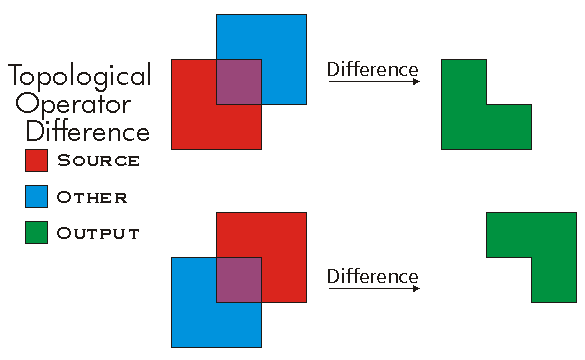
//The following code shows to wrap a line segment into a polyline in C#
//Assume a line (line1 as ILine) is already created
object obj = Type.Missing;
ISegmentCollection segCollection = new PolylineClass() as ISegmentCollection;
segCollection.AddSegment((ISegment)line1, ref obj, ref obj);
//Set the spatial reference on the new polyline
//The spatial reference is not transfered automatically from the segments
IGeometry geom = segCollection as IGeometry;
geom.SpatialReference = spatialRef;
//Can now be used with ITopologicalOperator methods
Dimension
The topological dimension of this geometry.
virtual esriGeometryDimension Dimension { get; }Returns
Remarks
Note: At 9.0, Multipatches are now considered as two dimensional geometry. esriGeometry3Dimension will be used for an upcoming new geometry type.
-1 esriGeometryNoDimension
1 esriGeometry0Dimension
2 esriGeometry1Dimension
4 esriGeometry2Dimension
5 esriGeometry25Dimension
6 esriGeometry3Dimension

Disjoint(IGeometry)
Indicates if the two geometries share no points in common. Negate this result to compute the Intersect relation.
virtual bool Disjoint(IGeometry other)Parameters
otherIGeometry
Returns
Remarks
Only geometries that support the IRelationalOperator interface can be used as input geometries.
Two geometries are disjoint if either one is empty.
Disjoint example. Only "true" relationships are showed in this picture.

Envelope
Creates a copy of this geometry's envelope and returns it.
virtual IEnvelope Envelope { get; }Returns
Examples
<p class="MsoNormal" style=
"MARGIN: 0in 0in 0pt; LINE-HEIGHT: normal; mso-layout-grid-align: none">
<span style=
"FONT-SIZE: 10pt; FONT-FAMILY: 'Courier New'; mso-no-proof: yes"><span style="mso-spacerun: yes">
<img src="./bitmaps/envelope.gif" align=
"baseline"></span></span></p>
<p class="MsoNormal" style=
"MARGIN: 0in 0in 0pt; LINE-HEIGHT: normal; mso-layout-grid-align: none">
 </p>
<p class="MsoNormal" style=
"MARGIN: 0in 0in 0pt; LINE-HEIGHT: normal; mso-layout-grid-align: none">
<span style=
"FONT-SIZE: 10pt; FONT-FAMILY: 'Courier New'; mso-no-proof: yes"><span style="mso-spacerun: yes">
       </span> <span style=
"COLOR: blue">public</span> <span style="COLOR: blue">static</span>
<span style="COLOR: teal">IGeometry</span>
GetEnvelopeGeometry()</span></p>
<p class="MsoNormal" style=
"MARGIN: 0in 0in 0pt; LINE-HEIGHT: normal; mso-layout-grid-align: none">
<span style=
"FONT-SIZE: 10pt; FONT-FAMILY: 'Courier New'; mso-no-proof: yes"><span style="mso-spacerun: yes">
       </span> {</span></p>
<p class="MsoNormal" style=
"MARGIN: 0in 0in 0pt; LINE-HEIGHT: normal; mso-layout-grid-align: none">
<span style=
"FONT-SIZE: 10pt; FONT-FAMILY: 'Courier New'; mso-no-proof: yes"><span style="mso-spacerun: yes">
           </span>
<span style="COLOR: blue">const</span> <span style=
"COLOR: blue">double</span> DeltaX = 2.5;</span></p>
<p class="MsoNormal" style=
"MARGIN: 0in 0in 0pt; LINE-HEIGHT: normal; mso-layout-grid-align: none">
<span style=
"FONT-SIZE: 10pt; FONT-FAMILY: 'Courier New'; mso-no-proof: yes"><span style="mso-spacerun: yes">
           </span>
<span style="COLOR: blue">const</span> <span style=
"COLOR: blue">double</span> DeltaY = 2.5;</span></p>
<p class="MsoNormal" style=
"MARGIN: 0in 0in 0pt; LINE-HEIGHT: normal; mso-layout-grid-align: none">
<span style=
"FONT-SIZE: 10pt; FONT-FAMILY: 'Courier New'; mso-no-proof: yes"><span style="mso-spacerun: yes">
           </span>
<span style="COLOR: blue">const</span> <span style=
"COLOR: blue">double</span> DeltaZ = 2.5;</span></p>
<p class="MsoNormal" style=
"MARGIN: 0in 0in 0pt; LINE-HEIGHT: normal; mso-layout-grid-align: none">
<span style=
"FONT-SIZE: 10pt; FONT-FAMILY: 'Courier New'; mso-no-proof: yes"> </span></p>
<p class="MsoNormal" style=
"MARGIN: 0in 0in 0pt; LINE-HEIGHT: normal; mso-layout-grid-align: none">
<span style=
"FONT-SIZE: 10pt; FONT-FAMILY: 'Courier New'; mso-no-proof: yes"><span style="mso-spacerun: yes">
           </span>
<span style="COLOR: teal">IPoint</span> centerPoint =
GetPoint();</span></p>
<p class="MsoNormal" style=
"MARGIN: 0in 0in 0pt; LINE-HEIGHT: normal; mso-layout-grid-align: none">
<span style=
"FONT-SIZE: 10pt; FONT-FAMILY: 'Courier New'; mso-no-proof: yes"> </span></p>
<p class="MsoNormal" style=
"MARGIN: 0in 0in 0pt; LINE-HEIGHT: normal; mso-layout-grid-align: none">
<span style=
"FONT-SIZE: 10pt; FONT-FAMILY: 'Courier New'; mso-no-proof: yes"><span style="mso-spacerun: yes">
           </span>
<span style="COLOR: teal">IEnvelope</span> envelope = <span style=
"COLOR: blue">new</span> <span style=
"COLOR: teal">EnvelopeClass</span>();</span></p>
<p class="MsoNormal" style=
"MARGIN: 0in 0in 0pt; LINE-HEIGHT: normal; mso-layout-grid-align: none">
<span style=
"FONT-SIZE: 10pt; FONT-FAMILY: 'Courier New'; mso-no-proof: yes"><span style="mso-spacerun: yes">
           </span>
envelope.XMin = centerPoint.X - DeltaX;</span></p>
<p class="MsoNormal" style=
"MARGIN: 0in 0in 0pt; LINE-HEIGHT: normal; mso-layout-grid-align: none">
<span style=
"FONT-SIZE: 10pt; FONT-FAMILY: 'Courier New'; mso-no-proof: yes"><span style="mso-spacerun: yes">
           </span>
envelope.XMax = centerPoint.X + DeltaX;</span></p>
<p class="MsoNormal" style=
"MARGIN: 0in 0in 0pt; LINE-HEIGHT: normal; mso-layout-grid-align: none">
<span style=
"FONT-SIZE: 10pt; FONT-FAMILY: 'Courier New'; mso-no-proof: yes"><span style="mso-spacerun: yes">
           </span>
envelope.YMin = centerPoint.Y - DeltaY;</span></p>
<p class="MsoNormal" style=
"MARGIN: 0in 0in 0pt; LINE-HEIGHT: normal; mso-layout-grid-align: none">
<span style=
"FONT-SIZE: 10pt; FONT-FAMILY: 'Courier New'; mso-no-proof: yes"><span style="mso-spacerun: yes">
           </span>
envelope.YMax = centerPoint.Y + DeltaY;</span></p>
<p class="MsoNormal" style=
"MARGIN: 0in 0in 0pt; LINE-HEIGHT: normal; mso-layout-grid-align: none">
<span style=
"FONT-SIZE: 10pt; FONT-FAMILY: 'Courier New'; mso-no-proof: yes"><span style="mso-spacerun: yes">
           </span>
envelope.ZMin = centerPoint.Z - DeltaZ;</span></p>
<p class="MsoNormal" style=
"MARGIN: 0in 0in 0pt; LINE-HEIGHT: normal; mso-layout-grid-align: none">
<span style=
"FONT-SIZE: 10pt; FONT-FAMILY: 'Courier New'; mso-no-proof: yes"><span style="mso-spacerun: yes">
           </span>
envelope.ZMax = centerPoint.Z + DeltaZ;</span></p>
<p class="MsoNormal" style=
"MARGIN: 0in 0in 0pt; LINE-HEIGHT: normal; mso-layout-grid-align: none">
<span style=
"FONT-SIZE: 10pt; FONT-FAMILY: 'Courier New'; mso-no-proof: yes"> </span></p>
<p class="MsoNormal" style=
"MARGIN: 0in 0in 0pt; LINE-HEIGHT: normal; mso-layout-grid-align: none">
<span style=
"FONT-SIZE: 10pt; FONT-FAMILY: 'Courier New'; mso-no-proof: yes"><span style="mso-spacerun: yes">
           </span>
MakeZAware(envelope <span style="COLOR: blue">as</span>
<span style="COLOR: teal">IGeometry</span>);</span></p>
<p class="MsoNormal" style=
"MARGIN: 0in 0in 0pt; LINE-HEIGHT: normal; mso-layout-grid-align: none">
<span style=
"FONT-SIZE: 10pt; FONT-FAMILY: 'Courier New'; mso-no-proof: yes"> </span></p>
<p class="MsoNormal" style=
"MARGIN: 0in 0in 0pt; LINE-HEIGHT: normal; mso-layout-grid-align: none">
<span style=
"FONT-SIZE: 10pt; FONT-FAMILY: 'Courier New'; mso-no-proof: yes"><span style="mso-spacerun: yes">
           </span>
<span style="COLOR: blue">return</span> envelope <span style=
"COLOR: blue">as</span> <span style=
"COLOR: teal">IGeometry</span>;</span></p>
<p class="MsoNormal" style="MARGIN: 0in 0in 10pt"><span style=
"FONT-SIZE: 10pt; LINE-HEIGHT: 115%; FONT-FAMILY: 'Courier New'; mso-no-proof: yes">
<span style=
"mso-spacerun: yes">       </span>
}</span></p>
<p class="MsoNormal" style=
"MARGIN: 0in 0in 0pt; LINE-HEIGHT: normal; mso-layout-grid-align: none">
<span style=
"FONT-SIZE: 10pt; FONT-FAMILY: 'Courier New'; mso-no-proof: yes"><span style="mso-spacerun: yes">
       </span> <span style=
"COLOR: blue">private</span> <span style=
"COLOR: blue">static</span> <span style="COLOR: teal">IPoint</span>
GetPoint()</span></p>
<p class="MsoNormal" style=
"MARGIN: 0in 0in 0pt; LINE-HEIGHT: normal; mso-layout-grid-align: none">
<span style=
"FONT-SIZE: 10pt; FONT-FAMILY: 'Courier New'; mso-no-proof: yes"><span style="mso-spacerun: yes">
       </span> {</span></p>
<p class="MsoNormal" style=
"MARGIN: 0in 0in 0pt; LINE-HEIGHT: normal; mso-layout-grid-align: none">
<span style=
"FONT-SIZE: 10pt; FONT-FAMILY: 'Courier New'; mso-no-proof: yes"><span style="mso-spacerun: yes">
           </span>
<span style="COLOR: blue">const</span> <span style=
"COLOR: blue">double</span> Min = -10;</span></p>
<p class="MsoNormal" style=
"MARGIN: 0in 0in 0pt; LINE-HEIGHT: normal; mso-layout-grid-align: none">
<span style=
"FONT-SIZE: 10pt; FONT-FAMILY: 'Courier New'; mso-no-proof: yes"><span style="mso-spacerun: yes">
           </span>
<span style="COLOR: blue">const</span> <span style=
"COLOR: blue">double</span> Max = 10;</span></p>
<p class="MsoNormal" style=
"MARGIN: 0in 0in 0pt; LINE-HEIGHT: normal; mso-layout-grid-align: none">
<span style=
"FONT-SIZE: 10pt; FONT-FAMILY: 'Courier New'; mso-no-proof: yes"> </span></p>
<p class="MsoNormal" style=
"MARGIN: 0in 0in 0pt; LINE-HEIGHT: normal; mso-layout-grid-align: none">
<span style=
"FONT-SIZE: 10pt; FONT-FAMILY: 'Courier New'; mso-no-proof: yes"><span style="mso-spacerun: yes">
           </span>
<span style="COLOR: teal">Random</span> random = <span style=
"COLOR: blue">new</span> <span style=
"COLOR: teal">Random</span>();</span></p>
<p class="MsoNormal" style=
"MARGIN: 0in 0in 0pt; LINE-HEIGHT: normal; mso-layout-grid-align: none">
<span style=
"FONT-SIZE: 10pt; FONT-FAMILY: 'Courier New'; mso-no-proof: yes"> </span></p>
<p class="MsoNormal" style=
"MARGIN: 0in 0in 0pt; LINE-HEIGHT: normal; mso-layout-grid-align: none">
<span style=
"FONT-SIZE: 10pt; FONT-FAMILY: 'Courier New'; mso-no-proof: yes"><span style="mso-spacerun: yes">
           </span>
<span style="COLOR: blue">double</span> x = Min + (Max - Min) *
random.NextDouble();</span></p>
<p class="MsoNormal" style=
"MARGIN: 0in 0in 0pt; LINE-HEIGHT: normal; mso-layout-grid-align: none">
<span style=
"FONT-SIZE: 10pt; FONT-FAMILY: 'Courier New'; mso-no-proof: yes"><span style="mso-spacerun: yes">
           </span>
<span style="COLOR: blue">double</span> y = Min + (Max - Min) *
random.NextDouble();</span></p>
<p class="MsoNormal" style=
"MARGIN: 0in 0in 0pt; LINE-HEIGHT: normal; mso-layout-grid-align: none">
<span style=
"FONT-SIZE: 10pt; FONT-FAMILY: 'Courier New'; mso-no-proof: yes"><span style="mso-spacerun: yes">
           </span>
<span style="COLOR: blue">double</span> z = Min + (Max - Min) *
random.NextDouble();</span></p>
<p class="MsoNormal" style=
"MARGIN: 0in 0in 0pt; LINE-HEIGHT: normal; mso-layout-grid-align: none">
<span style=
"FONT-SIZE: 10pt; FONT-FAMILY: 'Courier New'; mso-no-proof: yes"> </span></p>
<p class="MsoNormal" style=
"MARGIN: 0in 0in 0pt; LINE-HEIGHT: normal; mso-layout-grid-align: none">
<span style=
"FONT-SIZE: 10pt; FONT-FAMILY: 'Courier New'; mso-no-proof: yes"><span style="mso-spacerun: yes">
           </span>
<span style="COLOR: blue">return</span> ConstructPoint3D(x, y,
z);</span></p>
<p class="MsoNormal" style=
"MARGIN: 0in 0in 0pt; LINE-HEIGHT: normal; mso-layout-grid-align: none">
<span style=
"FONT-SIZE: 10pt; FONT-FAMILY: 'Courier New'; mso-no-proof: yes"><span style="mso-spacerun: yes">
       </span> }</span></p>
<p class="MsoNormal" style=
"MARGIN: 0in 0in 0pt; LINE-HEIGHT: normal; mso-layout-grid-align: none">
<span style=
"FONT-SIZE: 10pt; FONT-FAMILY: 'Courier New'; mso-no-proof: yes"> </span></p>
<p class="MsoNormal" style=
"MARGIN: 0in 0in 0pt; LINE-HEIGHT: normal; mso-layout-grid-align: none">
<span style=
"FONT-SIZE: 10pt; COLOR: black; FONT-FAMILY: 'Courier New'; mso-no-proof: yes; mso-fareast-font-family: 'Times New Roman'">
<span style=
"mso-spacerun: yes">       </span></span>
<span style=
"FONT-SIZE: 10pt; COLOR: blue; FONT-FAMILY: 'Courier New'; mso-no-proof: yes; mso-fareast-font-family: 'Times New Roman'">
private</span> <span style=
"FONT-SIZE: 10pt; COLOR: blue; FONT-FAMILY: 'Courier New'; mso-no-proof: yes; mso-fareast-font-family: 'Times New Roman'">
static</span> <span style=
"FONT-SIZE: 10pt; COLOR: teal; FONT-FAMILY: 'Courier New'; mso-no-proof: yes; mso-fareast-font-family: 'Times New Roman'">
IPoint</span> <span style=
"FONT-SIZE: 10pt; COLOR: black; FONT-FAMILY: 'Courier New'; mso-no-proof: yes; mso-fareast-font-family: 'Times New Roman'">
ConstructPoint3D(</span><span style=
"FONT-SIZE: 10pt; COLOR: blue; FONT-FAMILY: 'Courier New'; mso-no-proof: yes; mso-fareast-font-family: 'Times New Roman'">double</span>
<span style=
"FONT-SIZE: 10pt; COLOR: black; FONT-FAMILY: 'Courier New'; mso-no-proof: yes; mso-fareast-font-family: 'Times New Roman'">
x,</span> <span style=
"FONT-SIZE: 10pt; COLOR: blue; FONT-FAMILY: 'Courier New'; mso-no-proof: yes; mso-fareast-font-family: 'Times New Roman'">
double</span> <span style=
"FONT-SIZE: 10pt; COLOR: black; FONT-FAMILY: 'Courier New'; mso-no-proof: yes; mso-fareast-font-family: 'Times New Roman'">
y,</span> <span style=
"FONT-SIZE: 10pt; COLOR: blue; FONT-FAMILY: 'Courier New'; mso-no-proof: yes; mso-fareast-font-family: 'Times New Roman'">
double</span> <span style=
"FONT-SIZE: 10pt; COLOR: black; FONT-FAMILY: 'Courier New'; mso-no-proof: yes; mso-fareast-font-family: 'Times New Roman'">
z)</span></p>
<p class="MsoNormal" style=
"MARGIN: 0in 0in 0pt; LINE-HEIGHT: normal; mso-layout-grid-align: none">
<span style=
"FONT-SIZE: 10pt; COLOR: black; FONT-FAMILY: 'Courier New'; mso-no-proof: yes; mso-fareast-font-family: 'Times New Roman'">
<span style=
"mso-spacerun: yes">       </span>
{</span></p>
<p class="MsoNormal" style=
"MARGIN: 0in 0in 0pt; LINE-HEIGHT: normal; mso-layout-grid-align: none">
<span style=
"FONT-SIZE: 10pt; COLOR: black; FONT-FAMILY: 'Courier New'; mso-no-proof: yes; mso-fareast-font-family: 'Times New Roman'">
<span style=
"mso-spacerun: yes">           </span></span>
<span style=
"FONT-SIZE: 10pt; COLOR: teal; FONT-FAMILY: 'Courier New'; mso-no-proof: yes; mso-fareast-font-family: 'Times New Roman'">
IPoint</span> <span style=
"FONT-SIZE: 10pt; COLOR: black; FONT-FAMILY: 'Courier New'; mso-no-proof: yes; mso-fareast-font-family: 'Times New Roman'">
point = ConstructPoint2D(x, y);</span></p>
<p class="MsoNormal" style=
"MARGIN: 0in 0in 0pt; LINE-HEIGHT: normal; mso-layout-grid-align: none">
<span style=
"FONT-SIZE: 10pt; COLOR: black; FONT-FAMILY: 'Courier New'; mso-no-proof: yes; mso-fareast-font-family: 'Times New Roman'">
<span style=
"mso-spacerun: yes">           </span>
point.Z = z;<br>
<br>
<span style=
"mso-spacerun: yes">           </span></span>
<span style=
"FONT-SIZE: 10pt; COLOR: blue; FONT-FAMILY: 'Courier New'; mso-no-proof: yes; mso-fareast-font-family: 'Times New Roman'">
return</span> <span style=
"FONT-SIZE: 10pt; COLOR: black; FONT-FAMILY: 'Courier New'; mso-no-proof: yes; mso-fareast-font-family: 'Times New Roman'">
point;</span></p>
<p class="MsoNormal" style=
"MARGIN: 0in 0in 0pt; LINE-HEIGHT: normal; mso-layout-grid-align: none">
<span style=
"FONT-SIZE: 10pt; COLOR: black; FONT-FAMILY: 'Courier New'; mso-no-proof: yes; mso-fareast-font-family: 'Times New Roman'">
<span style=
"mso-spacerun: yes">       </span>
}<br>
<br style="mso-special-character: line-break">
<br style="mso-special-character: line-break"></span></p>
<p class="MsoNormal" style=
"MARGIN: 0in 0in 0pt; LINE-HEIGHT: normal; mso-layout-grid-align: none">
<span style=
"FONT-SIZE: 10pt; COLOR: black; FONT-FAMILY: 'Courier New'; mso-no-proof: yes; mso-fareast-font-family: 'Times New Roman'">
<span style=
"mso-spacerun: yes">       </span></span>
<span style=
"FONT-SIZE: 10pt; COLOR: blue; FONT-FAMILY: 'Courier New'; mso-no-proof: yes; mso-fareast-font-family: 'Times New Roman'">
private</span> <span style=
"FONT-SIZE: 10pt; COLOR: blue; FONT-FAMILY: 'Courier New'; mso-no-proof: yes; mso-fareast-font-family: 'Times New Roman'">
static</span> <span style=
"FONT-SIZE: 10pt; COLOR: teal; FONT-FAMILY: 'Courier New'; mso-no-proof: yes; mso-fareast-font-family: 'Times New Roman'">
IPoint</span> <span style=
"FONT-SIZE: 10pt; COLOR: black; FONT-FAMILY: 'Courier New'; mso-no-proof: yes; mso-fareast-font-family: 'Times New Roman'">
ConstructPoint2D(</span><span style=
"FONT-SIZE: 10pt; COLOR: blue; FONT-FAMILY: 'Courier New'; mso-no-proof: yes; mso-fareast-font-family: 'Times New Roman'">double</span>
<span style=
"FONT-SIZE: 10pt; COLOR: black; FONT-FAMILY: 'Courier New'; mso-no-proof: yes; mso-fareast-font-family: 'Times New Roman'">
x,</span> <span style=
"FONT-SIZE: 10pt; COLOR: blue; FONT-FAMILY: 'Courier New'; mso-no-proof: yes; mso-fareast-font-family: 'Times New Roman'">
double</span> <span style=
"FONT-SIZE: 10pt; COLOR: black; FONT-FAMILY: 'Courier New'; mso-no-proof: yes; mso-fareast-font-family: 'Times New Roman'">
y)</span></p>
<p class="MsoNormal" style=
"MARGIN: 0in 0in 0pt; LINE-HEIGHT: normal; mso-layout-grid-align: none">
<span style=
"FONT-SIZE: 10pt; COLOR: black; FONT-FAMILY: 'Courier New'; mso-no-proof: yes; mso-fareast-font-family: 'Times New Roman'">
<span style=
"mso-spacerun: yes">       </span>
{</span></p>
<p class="MsoNormal" style=
"MARGIN: 0in 0in 0pt; LINE-HEIGHT: normal; mso-layout-grid-align: none">
<span style=
"FONT-SIZE: 10pt; COLOR: black; FONT-FAMILY: 'Courier New'; mso-no-proof: yes; mso-fareast-font-family: 'Times New Roman'">
<span style=
"mso-spacerun: yes">           </span></span>
<span style=
"FONT-SIZE: 10pt; COLOR: teal; FONT-FAMILY: 'Courier New'; mso-no-proof: yes; mso-fareast-font-family: 'Times New Roman'">
IPoint</span> <span style=
"FONT-SIZE: 10pt; COLOR: black; FONT-FAMILY: 'Courier New'; mso-no-proof: yes; mso-fareast-font-family: 'Times New Roman'">
point =</span> <span style=
"FONT-SIZE: 10pt; COLOR: blue; FONT-FAMILY: 'Courier New'; mso-no-proof: yes; mso-fareast-font-family: 'Times New Roman'">
new</span> <span style=
"FONT-SIZE: 10pt; COLOR: teal; FONT-FAMILY: 'Courier New'; mso-no-proof: yes; mso-fareast-font-family: 'Times New Roman'">
PointClass</span><span style=
"FONT-SIZE: 10pt; COLOR: black; FONT-FAMILY: 'Courier New'; mso-no-proof: yes; mso-fareast-font-family: 'Times New Roman'">();</span></p>
<p class="MsoNormal" style=
"MARGIN: 0in 0in 0pt; LINE-HEIGHT: normal; mso-layout-grid-align: none">
<span style=
"FONT-SIZE: 10pt; COLOR: black; FONT-FAMILY: 'Courier New'; mso-no-proof: yes; mso-fareast-font-family: 'Times New Roman'">
<span style=
"mso-spacerun: yes">           </span>
point.PutCoords(x, y);<br>
<span style="mso-spacerun: yes"> </span></span></p>
<p class="MsoNormal" style=
"MARGIN: 0in 0in 0pt; LINE-HEIGHT: normal; mso-layout-grid-align: none">
<span style=
"FONT-SIZE: 10pt; COLOR: black; FONT-FAMILY: 'Courier New'; mso-no-proof: yes; mso-fareast-font-family: 'Times New Roman'">
<span style=
"mso-spacerun: yes">           </span></span>
<span style=
"FONT-SIZE: 10pt; COLOR: blue; FONT-FAMILY: 'Courier New'; mso-no-proof: yes; mso-fareast-font-family: 'Times New Roman'">
return</span> <span style=
"FONT-SIZE: 10pt; COLOR: black; FONT-FAMILY: 'Courier New'; mso-no-proof: yes; mso-fareast-font-family: 'Times New Roman'">
point;</span></p>
<p class="MsoNormal" style=
"MARGIN: 0in 0in 10pt; LINE-HEIGHT: normal"><span style=
"FONT-SIZE: 10pt; COLOR: black; FONT-FAMILY: 'Courier New'; mso-no-proof: yes; mso-fareast-font-family: 'Times New Roman'">
<span style=
"mso-spacerun: yes">       </span>
}</span></p>
<p class="MsoNormal" style=
"MARGIN: 0in 0in 0pt; LINE-HEIGHT: normal; mso-layout-grid-align: none">
<span style=
"FONT-SIZE: 10pt; FONT-FAMILY: 'Courier New'; mso-no-proof: yes"><span style="mso-spacerun: yes">
       </span> <span style=
"COLOR: blue">private</span> <span style=
"COLOR: blue">static</span> <span style="COLOR: blue">void</span>
MakeZAware(<span style="COLOR: teal">IGeometry</span>
geometry)</span></p>
<p class="MsoNormal" style=
"MARGIN: 0in 0in 0pt; LINE-HEIGHT: normal; mso-layout-grid-align: none">
<span style=
"FONT-SIZE: 10pt; FONT-FAMILY: 'Courier New'; mso-no-proof: yes"><span style="mso-spacerun: yes">
       </span> {</span></p>
<p class="MsoNormal" style=
"MARGIN: 0in 0in 0pt; LINE-HEIGHT: normal; mso-layout-grid-align: none">
<span style=
"FONT-SIZE: 10pt; FONT-FAMILY: 'Courier New'; mso-no-proof: yes"><span style="mso-spacerun: yes">
           </span>
<span style="COLOR: teal">IZAware</span> zAware = geometry
<span style="COLOR: blue">as</span> <span style=
"COLOR: teal">IZAware</span>;</span></p>
<p class="MsoNormal" style=
"MARGIN: 0in 0in 0pt; LINE-HEIGHT: normal; mso-layout-grid-align: none">
<span style=
"FONT-SIZE: 10pt; FONT-FAMILY: 'Courier New'; mso-no-proof: yes"><span style="mso-spacerun: yes">
           </span>
zAware.ZAware = <span style="COLOR: blue">true</span>;</span></p>
<p class="MsoNormal" style=
"MARGIN: 0in 0in 0pt; LINE-HEIGHT: normal; mso-layout-grid-align: none">
<span style=
"FONT-SIZE: 10pt; FONT-FAMILY: 'Courier New'; mso-no-proof: yes"><span style="mso-spacerun: yes">
       </span> }</span></p>
Remarks

Equals(IGeometry)
Indicates if the two geometries are of the same type and define the same set of points in the plane.
virtual bool Equals(IGeometry other)Parameters
otherIGeometry
Returns
Remarks
Only geometries that support the IRelationalOperator interface can be used as input geometries. GeometryBags are not supported. IRelationalOperator::Equals delegates to ITopologicalOperatorSymmetricDifference and returns true when that method returns an empty geometry; M's and Z's are ignored. Please use IClone::IsEqual if M's and Z's need to be compared.
IClone::IsEqual simply iterates over each segment in each geometry, in index order, and compares their types and coordinates (but using the spatial reference's cluster tolerances to determine equality of coordinates).
Only "true" relationships are showed in this picture.

The RCW for the IRelationalOperator inherits from System.Object, as do all reference types in .NET. The System.Object type has a method called Equals, which results in the IRelationalOperator RCW having two overloaded versions of the Equals method. Ensure that you are not using the Equals method inherited from the System.Object class by mistake, by making sure you pass in an IGeometry reference to the Equals method. For example, the following extract of code from a C# console application demonstrates calling Equals correctly.
ESRI.ArcGIS.Geometry.IPoint pt1 = new ESRI.ArcGIS.Geometry.PointClass();
pt1.PutCoords(5, 5);
ESRI.ArcGIS.Geometry.IPoint pt2 = new ESRI.ArcGIS.Geometry.PointClass();
pt2.PutCoords(5, 5);
ESRI.ArcGIS.Geometry.IRelationalOperator rel1 = pt1 as ESRI.ArcGIS.Geometry.IRelationalOperator;
ESRI.ArcGIS.Geometry.IGeometry geom2 = pt2 as ESRI.ArcGIS.Geometry.IGeometry;
bool relEqual = rel1.Equals(pt2); //calling IRelationalOperator::Equals
Console.WriteLine("Equal: " + relEqual.ToString());
bool netEqual =  rel1.Equals(pt2 as object);  //calling Object::Equals
Console.WriteLine("Equal: " + netEqual.ToString());
GeoNormalize()
Shifts longitudes, if need be, into a continuous range of 360 degrees.
virtual void GeoNormalize()Remarks
GeoNormalizeFromLongitude(double)
Normalizes longitudes into a continuous range containing the longitude. This method is obsolete.
virtual void GeoNormalizeFromLongitude(double Longitude)Parameters
Longitudedouble
Remarks
GeometriesChanged()
Tells this geometry collection that some of its geometries have been altered. Use this method on polylines, polygons and multipatches after directly editing one of its parts.
virtual void GeometriesChanged()Geometry[int]
A reference to the ith geometry.
virtual IGeometry Geometry[int Index] { get; }Parameters
Indexint
Returns
Remarks
Note: The GeometryType returned by the Geometry method depends on which object type points the IGeometryCollection pointer.
| IGeometryCollection Object GeometryType | Returned Object GeometryType |
| Polygon |
Rings |
| Polyline |
Paths |
| Multipoint |
Points |
| Multipatch |
TriangleFans or TriangleStrips or Rings |
| TriangleFan |
Points |
| TriangleStrip |
Points |
| Geometry Bag |
Any type of IGeometry |
GeometryCount
The number of geometries in this collection.
virtual int GeometryCount { get; }Returns
GeometryType
The type of this geometry.
virtual esriGeometryType GeometryType { get; }Returns
Remarks
esriGeometryNull          = 0
esriGeometryPoint         = 1
esriGeometryMultipoint    = 2
esriGeometryPolyline      = 3
esriGeometryPolygon       = 4
esriGeometryEnvelope      = 5
esriGeometryPath          = 6
esriGeometryAny           = 7
esriGeometryMultiPatch    = 9
esriGeometryRing          = 11
esriGeometryLine          = 13
esriGeometryCircularArc   = 14
esriGeometryBezier3Curve  = 15
esriGeometryEllipticArc   = 16
esriGeometryBag           = 17
esriGeometryTriangleStrip = 18
esriGeometryTriangleFan   = 19
esriGeometryRay           = 20
esriGeometrySphere        = 21

GetClassID(out Guid)
virtual void GetClassID(out Guid pClassID)Parameters
pClassIDGuid
GetSizeMax(out _ULARGE_INTEGER)
virtual void GetSizeMax(out _ULARGE_INTEGER pcbSize)Parameters
pcbSize_ULARGE_INTEGER
IGeometry2_Dimension
virtual esriGeometryDimension IGeometry2_Dimension { get; }Returns
IGeometry2_Envelope
virtual IEnvelope IGeometry2_Envelope { get; }Returns
IGeometry2_GeoNormalize()
virtual void IGeometry2_GeoNormalize()IGeometry2_GeoNormalizeFromLongitude(double)
virtual void IGeometry2_GeoNormalizeFromLongitude(double Longitude)Parameters
Longitudedouble
IGeometry2_GeometryType
virtual esriGeometryType IGeometry2_GeometryType { get; }Returns
IGeometry2_IsEmpty
virtual bool IGeometry2_IsEmpty { get; }Returns
IGeometry2_Project(ISpatialReference)
virtual void IGeometry2_Project(ISpatialReference newReferenceSystem)Parameters
newReferenceSystemISpatialReference
IGeometry2_QueryEnvelope(IEnvelope)
virtual void IGeometry2_QueryEnvelope(IEnvelope outEnvelope)Parameters
outEnvelopeIEnvelope
IGeometry2_SetEmpty()
virtual void IGeometry2_SetEmpty()IGeometry2_SnapToSpatialReference()
virtual void IGeometry2_SnapToSpatialReference()IGeometry2_SpatialReference
virtual ISpatialReference IGeometry2_SpatialReference { get; set; }Returns
IGeometry3_Dimension
virtual esriGeometryDimension IGeometry3_Dimension { get; }Returns
IGeometry3_Envelope
virtual IEnvelope IGeometry3_Envelope { get; }Returns
IGeometry3_GeoNormalize()
virtual void IGeometry3_GeoNormalize()IGeometry3_GeoNormalizeFromLongitude(double)
virtual void IGeometry3_GeoNormalizeFromLongitude(double Longitude)Parameters
Longitudedouble
IGeometry3_GeometryType
virtual esriGeometryType IGeometry3_GeometryType { get; }Returns
IGeometry3_IsEmpty
virtual bool IGeometry3_IsEmpty { get; }Returns
IGeometry3_Project(ISpatialReference)
virtual void IGeometry3_Project(ISpatialReference newReferenceSystem)Parameters
newReferenceSystemISpatialReference
IGeometry3_ProjectEx(ISpatialReference, esriTransformDirection, IGeoTransformation, bool, double, double)
virtual void IGeometry3_ProjectEx(ISpatialReference newReferenceSystem, esriTransformDirection Direction, IGeoTransformation GeoTransformation, bool bAngularDensify, double maxSegmentLength, double maxDeviation)Parameters
newReferenceSystemISpatialReferenceDirectionesriTransformDirectionGeoTransformationIGeoTransformationbAngularDensifyboolmaxSegmentLengthdoublemaxDeviationdouble
IGeometry3_QueryEnvelope(IEnvelope)
virtual void IGeometry3_QueryEnvelope(IEnvelope outEnvelope)Parameters
outEnvelopeIEnvelope
IGeometry3_SetEmpty()
virtual void IGeometry3_SetEmpty()IGeometry3_SnapToSpatialReference()
virtual void IGeometry3_SnapToSpatialReference()IGeometry3_SpatialReference
virtual ISpatialReference IGeometry3_SpatialReference { get; set; }Returns
IGeometry4_Dimension
virtual esriGeometryDimension IGeometry4_Dimension { get; }Returns
IGeometry4_Envelope
virtual IEnvelope IGeometry4_Envelope { get; }Returns
IGeometry4_GeoNormalize()
virtual void IGeometry4_GeoNormalize()IGeometry4_GeoNormalizeFromLongitude(double)
virtual void IGeometry4_GeoNormalizeFromLongitude(double Longitude)Parameters
Longitudedouble
IGeometry4_GeometryType
virtual esriGeometryType IGeometry4_GeometryType { get; }Returns
IGeometry4_IsEmpty
virtual bool IGeometry4_IsEmpty { get; }Returns
IGeometry4_Project(ISpatialReference)
virtual void IGeometry4_Project(ISpatialReference newReferenceSystem)Parameters
newReferenceSystemISpatialReference
IGeometry4_ProjectEx(ISpatialReference, esriTransformDirection, IGeoTransformation, bool, double, double)
virtual void IGeometry4_ProjectEx(ISpatialReference newReferenceSystem, esriTransformDirection Direction, IGeoTransformation GeoTransformation, bool bAngularDensify, double maxSegmentLength, double maxDeviation)Parameters
newReferenceSystemISpatialReferenceDirectionesriTransformDirectionGeoTransformationIGeoTransformationbAngularDensifyboolmaxSegmentLengthdoublemaxDeviationdouble
IGeometry4_QueryEnvelope(IEnvelope)
virtual void IGeometry4_QueryEnvelope(IEnvelope outEnvelope)Parameters
outEnvelopeIEnvelope
IGeometry4_QueryWKSEnvelope(out WKSEnvelope)
virtual void IGeometry4_QueryWKSEnvelope(out WKSEnvelope e)Parameters
IGeometry4_SetEmpty()
virtual void IGeometry4_SetEmpty()IGeometry4_SnapToSpatialReference()
virtual void IGeometry4_SnapToSpatialReference()IGeometry4_SpatialReference
virtual ISpatialReference IGeometry4_SpatialReference { get; set; }Returns
IGeometry5_Changed
virtual bool IGeometry5_Changed { get; set; }Returns
IGeometry5_Dimension
virtual esriGeometryDimension IGeometry5_Dimension { get; }Returns
IGeometry5_Envelope
virtual IEnvelope IGeometry5_Envelope { get; }Returns
IGeometry5_GeoNormalize()
virtual void IGeometry5_GeoNormalize()IGeometry5_GeoNormalizeFromLongitude(double)
virtual void IGeometry5_GeoNormalizeFromLongitude(double Longitude)Parameters
Longitudedouble
IGeometry5_GeometryType
virtual esriGeometryType IGeometry5_GeometryType { get; }Returns
IGeometry5_IsEmpty
virtual bool IGeometry5_IsEmpty { get; }Returns
IGeometry5_Project(ISpatialReference)
virtual void IGeometry5_Project(ISpatialReference newReferenceSystem)Parameters
newReferenceSystemISpatialReference
IGeometry5_ProjectEx(ISpatialReference, esriTransformDirection, IGeoTransformation, bool, double, double)
virtual void IGeometry5_ProjectEx(ISpatialReference newReferenceSystem, esriTransformDirection Direction, IGeoTransformation GeoTransformation, bool bAngularDensify, double maxSegmentLength, double maxDeviation)Parameters
newReferenceSystemISpatialReferenceDirectionesriTransformDirectionGeoTransformationIGeoTransformationbAngularDensifyboolmaxSegmentLengthdoublemaxDeviationdouble
IGeometry5_QueryEnvelope(IEnvelope)
virtual void IGeometry5_QueryEnvelope(IEnvelope outEnvelope)Parameters
outEnvelopeIEnvelope
IGeometry5_QueryWKSEnvelope(out WKSEnvelope)
virtual void IGeometry5_QueryWKSEnvelope(out WKSEnvelope e)Parameters
IGeometry5_SetEmpty()
virtual void IGeometry5_SetEmpty()IGeometry5_SnapToSpatialReference()
virtual void IGeometry5_SnapToSpatialReference()IGeometry5_SpatialReference
virtual ISpatialReference IGeometry5_SpatialReference { get; set; }Returns
IGeometryBag_Dimension
virtual esriGeometryDimension IGeometryBag_Dimension { get; }Returns
IGeometryBag_Envelope
virtual IEnvelope IGeometryBag_Envelope { get; }Returns
IGeometryBag_GeoNormalize()
virtual void IGeometryBag_GeoNormalize()IGeometryBag_GeoNormalizeFromLongitude(double)
virtual void IGeometryBag_GeoNormalizeFromLongitude(double Longitude)Parameters
Longitudedouble
IGeometryBag_GeometryType
virtual esriGeometryType IGeometryBag_GeometryType { get; }Returns
IGeometryBag_IsEmpty
virtual bool IGeometryBag_IsEmpty { get; }Returns
IGeometryBag_Project(ISpatialReference)
virtual void IGeometryBag_Project(ISpatialReference newReferenceSystem)Parameters
newReferenceSystemISpatialReference
IGeometryBag_QueryEnvelope(IEnvelope)
virtual void IGeometryBag_QueryEnvelope(IEnvelope outEnvelope)Parameters
outEnvelopeIEnvelope
IGeometryBag_SetEmpty()
virtual void IGeometryBag_SetEmpty()IGeometryBag_SnapToSpatialReference()
virtual void IGeometryBag_SnapToSpatialReference()IGeometryBag_SpatialReference
virtual ISpatialReference IGeometryBag_SpatialReference { get; set; }Returns
IPersistStream_GetClassID(out Guid)
virtual void IPersistStream_GetClassID(out Guid pClassID)Parameters
pClassIDGuid
InsertGeometries(int, int, ref IGeometry)
Inserts at the specified index references to some number of geometries in the input array. This method is intended for internal use only.
virtual void InsertGeometries(int Index, int Count, ref IGeometry newGeometries)Parameters
Remarks
The geometries are inserted before the ith (index) element in the list. Use an array of geometries and give the exact number (count ) of elements in the array. A too large value for the count parameter causes exceeding the boundary of the array and will cause an application error. To place the geometries last in the collection then use the addGeometries method.
When using C# you must use the IGeometryBridge interface to call this method.
When using VBNET you must use the IGeometryBridge interface to call this method.
InsertGeometryCollection(int, IGeometryCollection)
Inserts at the specified index references to all if the geometries in the input collection.
virtual void InsertGeometryCollection(int Index, IGeometryCollection newGeometries)Parameters
IndexintnewGeometriesIGeometryCollection
Remarks
InsertGeometryCollection merges one GeometryCollection within another at a specified index.
//C# Example: Insert GeometryCollection geomColl2 within geomColl at index 3.
geomColl.InsertGeometryCollection(3, geomColl2);
InterfaceSupportsErrorInfo(ref Guid)
virtual void InterfaceSupportsErrorInfo(ref Guid riid)Parameters
riidGuid
Intersect(IGeometry, esriGeometryDimension)
Constructs the geometry that is the set-theoretic intersection of the input geometries. Use different resultDimension values to generate results of different dimensions.
virtual IGeometry Intersect(IGeometry other, esriGeometryDimension resultDimension)Parameters
otherIGeometryresultDimensionesriGeometryDimension
Returns
Remarks
Intersection is basically an AND between input geometries.
ITopologicalOperator methods must be applied on high-level geometries only. High-Level geometries are point, multipoint, polyline and polygon. To use this method with low-level geometries such as segments (Line, Circular Arc, Elliptic Arc, Bézier Curve), paths or rings, they must be wrapped into high-level geometries types.
Note that when esriGeometryNoDimension is specified as resultDimension, the output will be in the dimension of the minimum dimension of the input geometries.
This method does not support GeometryBags.
Since ArcGIS 9.2, Intersect has a larger cost - it takes longer to run the method. Therefore, it is a better approach to test if the two geometries are disjoint before calling Intersect.

//The following code shows to wrap a line segment into a polyline in C#
//Assume a line (line1 as ILine) is already created
object obj = Type.Missing;
ISegmentCollection segCollection = new PolylineClass() as ISegmentCollection;
segCollection.AddSegment((ISegment)line1, ref obj, ref obj);
//Set the spatial reference on the new polyline
//The spatial reference is not transfered automatically from the segments
IGeometry geom = segCollection as IGeometry;
geom.SpatialReference = spatialRef;
//Can now be used with ITopologicalOperator methods
Invalidate()
Invalidate the spatial index.
virtual void Invalidate()IsDirty()
virtual void IsDirty()IsEmpty
Indicates whether this geometry contains any points.
virtual bool IsEmpty { get; }Returns
IsEqual(IClone)
Indicates if the receiver and other have the same properties.
virtual bool IsEqual(IClone other)Parameters
otherIClone
Returns
IsIdentical(IClone)
Indicates if the receiver and other are the same object.
virtual bool IsIdentical(IClone other)Parameters
otherIClone
Returns
IsKnownSimple
Indicates whether this geometry is known (or assumed) to be topologically correct.
virtual bool IsKnownSimple { get; }Returns
Remarks
Here is the status of the IsKnownSimple flag in some common situations:
IsKnownSimple = 'False'
- A non-empty newly created geometry. For example, creating a polygon using IPointCollection sets the flag IsKnownSimple = 'false' on that geometry.
- Geometry after projection (IGeometry::Project )
- Geometry after generalization (IPolycurve::Generalize ) or smoothing(IPolycurve::Smooth )
- …
IsKnownSimple = 'True'
- A geometry coming directly from a feature class
- An empty geometry
- Output geometry of any method on ITopologicalOperator
- …
This method does not support GeometryBags.
IsSimple
Indicates whether this geometry is known (or assumed) to be topologically correct, after explicitly determining this if the geometry is not already known (or assumed) to be simple.
virtual bool IsSimple { get; }Returns
Remarks
ITopologicalOperator methods must be applied on high-level geometries only. High-Level geometries are point, multipoint, polyline and polygon. To use this method with low-level geometries such as segments (Line, Circular Arc, Elliptic Arc, Bézier Curve), paths or rings, they must be wrapped into high-level geometries types.
The xy cluster tolerance value of the geometry's associated spatial reference is used by this method. If the goal of this method is to determine if a geometry can be persisted in an sde (or other integer-based) layer without alteration, you may wish to use the minimum xy cluster tolerance value (ISpatialReferenceTolerance::SetMinimumXYTolerance) before applying this method (don't forget to set it back).
This method does not support GeometryBags.


//The following code shows to wrap a line segment into a polyline in C#
//Assume a line (line1 as ILine) is already created
object obj = Type.Missing;
ISegmentCollection segCollection = new PolylineClass() as ISegmentCollection;
segCollection.AddSegment((ISegment)line1, ref obj, ref obj);
//Set the spatial reference on the new polyline
//The spatial reference is not transfered automatically from the segments
IGeometry geom = segCollection as IGeometry;
geom.SpatialReference = spatialRef;
//Can now be used with ITopologicalOperator methods
Load(IStream)
virtual void Load(IStream pstm)Parameters
pstmIStream
LosslessExport
Indicates if this geometry bag exported itself to a shapefile buffer with no loss of information. Currently always returns false.
virtual bool LosslessExport { get; }Returns
Remarks
currently not implemented; always returns FALSE.
MinNamespaceSupported
The minimum namespace the class can serialize to (eg the 90 namespace).
virtual string MinNamespaceSupported { get; }Returns
Move(double, double)
Moves dx units horizontally and dy units vertically.
virtual void Move(double dx, double dy)Parameters
Remarks

MoveVector(ILine)
Moves a direction and distance v. v can be in a different spatial reference than the geometry being moved.
virtual void MoveVector(ILine v)Parameters
vILine
Remarks
Next()
Returns the next geometry in the enumeration.
virtual IGeometry Next()Returns
Overlaps(IGeometry)
Indicates if the intersection of the two geometries has the same dimension as one of the input geometries.
virtual bool Overlaps(IGeometry other)Parameters
otherIGeometry
Returns
Remarks
Only geometries that support the IRelationalOperator interface can be used as input geometries.
Overlaps only applies to polyline/polyline, polygon/polygon and multipoint/multipoint relations.
Two geometries do not overlap if either one is empty.
Overlaps examples. Only "true" relationships are showed in this picture.

Project(ISpatialReference)
Projects this geometry into a new spatial reference.
virtual void Project(ISpatialReference newReferenceSystem)Parameters
newReferenceSystemISpatialReference
Remarks
Note: This method can only be called upon the top level geometries (Points, Multipoints, Polylines and Polygons). If the from/to spatial references have different geographic coordinate systems, the Project method looks for a GeoTransformationsOperationSet. If the set of Geotransformations is present in memory, Project will use it to perform a geographic/datum Transformation. To use a specific geotransformation, use the IGeometry2::ProjectEx method.
//Create Spatial Reference Factory
ISpatialReferenceFactory srFactory = new SpatialReferenceEnvironmentClass();
ISpatialReference sr1;
//GCS to project from
IGeographicCoordinateSystem gcs = srFactory.CreateGeographicCoordinateSystem((int)esriSRGeoCSType.esriSRGeoCS_NAD1983);
sr1 = gcs;
sr1.SetFalseOriginAndUnits(-180, -90, 1000000);
//Projected Coordinate System to project into
IProjectedCoordinateSystem pcs = srFactory.CreateProjectedCoordinateSystem((int)esriSRProjCSType.esriSRProjCS_NAD1983N_AmericaLambert);
pcs.SetFalseOriginAndUnits(0, 0, 1000);
ISpatialReference sr2;
sr2 = pcs;
//Point to project
IPoint point = new PointClass() as IPoint;
point.PutCoords(-117.17, 34.06);
//Geometry Interface to do actual project
IGeometry geometry;
geometry = point;
geometry.SpatialReference = sr1;
geometry.Project(sr2);
point = geometry as IPoint;
double x;
double y;
point.QueryCoords(out x, out y);
Debug.Print("X: " + x.ToString());
Debug.Print("Y: " + y.ToString());
Project5(ISpatialReference, int)
Same as Project, but with additional parameter projectionHint.
virtual void Project5(ISpatialReference newSpatialReference, int ProjectionHint)Parameters
newSpatialReferenceISpatialReferenceProjectionHintint
ProjectEx(ISpatialReference, esriTransformDirection, IGeoTransformation, bool, double, double)
Projects a geometry, optionally applies a GeoTransformation, and optionally densifies the geometry.
virtual void ProjectEx(ISpatialReference newReferenceSystem, esriTransformDirection Direction, IGeoTransformation GeoTransformation, bool bAngularDensify, double maxSegmentLength, double maxDeviation)Parameters
newReferenceSystemISpatialReferenceDirectionesriTransformDirectionGeoTransformationIGeoTransformationbAngularDensifyboolmaxSegmentLengthdoublemaxDeviationdouble
Remarks
By default, ProjectEx will not densify geometries as they are projected. This can lead to the output geometries not reflecting the 'true' shape in the new coordinate system. A straight line in one coordinate system is not necessarily a straight line in a different coordinate system. Set the bAngularDensify parameter if you want to densify the geometries while they are projected.
//This example demonstrates how to use IGeometry2::ProjectEx
public void ProjectExExample()
{
//Create source spatial reference
ISpatialReferenceFactory spatialReferenceFactory = new SpatialReferenceEnvironmentClass();
ISpatialReference spatialReference = spatialReferenceFactory.CreateGeographicCoordinateSystem((int)esriSRGeoCSType.esriSRGeoCS_WGS1984);
spatialReference.SetFalseOriginAndUnits(-80.0000000232831, 39.9999999767169, 42949672.9);
//Create envelope and define its spatial reference
IEnvelope envelope = new EnvelopeClass();
envelope.PutCoords(-68.6076204314651, 49.6186709634653, -68.5531907607304, 49.6530789785679);
envelope.SpatialReference = spatialReference;
//Destination spatial reference
IProjectedCoordinateSystem projectedCoordinateSystem = spatialReferenceFactory.CreateProjectedCoordinateSystem((int)esriSRProjCSType.esriSRProjCS_NAD1927UTM_19N);
//Define the XYDomain equivalent to SetFalseOriginAndUnits
projectedCoordinateSystem.SetDomain(500000, 600000, 5300000, 5600000);
//Create a Geotransformation (Datum transformation)
IGeoTransformation geoTransformation = spatialReferenceFactory.CreateGeoTransformation((int)esriSRGeoTransformationType.esriSRGeoTransformation_NAD1927_To_WGS1984_12) as IGeoTransformation;
String report = "Print envelope coordinates before projection:\n" +
envelope.XMin + " , " + envelope.YMin + " , " + envelope.XMax + " , " + envelope.YMax + "\n\n\n";
//Project envelope
IGeometry2 geometry = envelope as IGeometry2;
geometry.ProjectEx(projectedCoordinateSystem as ISpatialReference, esriTransformDirection.esriTransformReverse, geoTransformation, false, 0, 0);
report = report + "Print envelope coordinates after projection:\n" +
envelope.XMin + " , " + envelope.YMin + " , " + envelope.XMax + " , " + envelope.YMax;
System.Windows.Forms.MessageBox.Show(report);
}
ProjectEx5(ISpatialReference, esriTransformDirection, ITransformation, bool, double, double, int)
Same as ProjectEx, but with additional parameter projectionHint.
virtual void ProjectEx5(ISpatialReference newReferenceSystem, esriTransformDirection Direction, ITransformation Transformation, bool bAngularDensify, double maxSegmentLength, double maxDeviation, int ProjectionHint)Parameters
newReferenceSystemISpatialReferenceDirectionesriTransformDirectionTransformationITransformationbAngularDensifyboolmaxSegmentLengthdoublemaxDeviationdoubleProjectionHintint
Remarks
By default, ProjectEx will not densify geometries as they are projected. This can lead to the output geometries not reflecting the 'true' shape in the new coordinate system. A straight line in one coordinate system is not necessarily a straight line in a different coordinate system. Set the bAngularDensify parameter if you want to densify the geometries while they are projected.
QueryClipped(IEnvelope, IGeometry)
Redefines clippedGeometry to be the intersection of this geometry and the clipping envelope.
virtual void QueryClipped(IEnvelope clipperEnvelope, IGeometry clippedGeometry)Parameters
Remarks
ITopologicalOperator methods must be applied on high-level geometries only. High-Level geometries are point, multipoint, polyline and polygon. To use this method with low-level geometries such as segments (Line, Circular Arc, Elliptic Arc, Bézier Curve), paths or rings, they must be wrapped into high-level geometries types.
The other geometry must be an high-level geometry. High-Level geometries are point, multipoint, polyline and polygon. To use it with low-level geometries such as segments (Line, Circular Arc, Elliptic Arc, Bézier Curve), path or ring they must be wrapped into high-level geometries type. The output geometry must be co-created prior to the query. The output geometry is not co-created by the method; it is populated. This can be used in performance critical situations. For example, creating the geometry only once outside a loop and use the query method could improve performance.
This method does not support GeometryBags.
//The following code shows to wrap a line segment into a polyline in C#
//Assume a line (line1 as ILine) is already created
object obj = Type.Missing;
ISegmentCollection segCollection = new PolylineClass() as ISegmentCollection;
segCollection.AddSegment((ISegment)line1, ref obj, ref obj);
//Set the spatial reference on the new polyline
//The spatial reference is not transfered automatically from the segments
IGeometry geom = segCollection as IGeometry;
geom.SpatialReference = spatialRef;
//Can now be used with ITopologicalOperator methods
QueryClippedDense(IEnvelope, double, IGeometry)
Redefines clippedGeometry to be the intersection of this geometry and the clipping envelope; densifies lines in the output contributed by the clipping envelope.
virtual void QueryClippedDense(IEnvelope clipperEnvelope, double denseDistance, IGeometry clippedGeometry)Parameters
Remarks
ITopologicalOperator methods must be applied on high-level geometries only. High-Level geometries are point, multipoint, polyline and polygon. To use this method with low-level geometries such as segments (Line, Circular Arc, Elliptic Arc, Bézier Curve), paths or rings, they must be wrapped into high-level geometries types.
The other geometry must be an high-level geometry. High-Level geometries are point, multipoint, polyline and polygon. To use it with low-level geometries such as segments (Line, Circular Arc, Elliptic Arc, Bézier Curve), path or ring they must be wrapped into high-level geometries type. The output geometry must be co-created prior to the query. The output geometry is not co-created by the method; it is populated. This can be used in performance critical situations. For example, creating the geometry only once outside a loop and use the query method could improve performance.
This method does not support GeometryBags.
QueryEnvelope(IEnvelope)
Copies this geometry's envelope properties into the specified envelope.
virtual void QueryEnvelope(IEnvelope outEnvelope)Parameters
outEnvelopeIEnvelope
Remarks
Note: The output geometry must be co-created prior to the query. The output geometry is not co-created by the method; it is populated. This can be used in performance critical situations. For example, creating the geometry only once outside a loop and use the query method could improve performance.
QueryGeometries(int, int, out IGeometry)
Populates the array with references to a sub-sequence of geometries. This method is intended for internal use only.
virtual void QueryGeometries(int Index, int Count, out IGeometry geometries)Parameters
Remarks
Note: The GeometryType returned by the QueryGeometries method depends on which object type points the IGeometryCollection pointer.
| IGeometryCollection Object GeometryType | Returned Object GeometryType |
| Polygon |
Rings |
| Polyline |
Paths |
| Multipoint |
Points |
| Multipatch |
TriangleFans or TriangleStrips or Rings |
| TriangleFan |
Points |
| TriangleStrip |
Points |
| Geometry Bag |
Any type of IGeometry |
When using C# you must use the IGeometryBridge interface to call this method.
When using VBNET you must use the IGeometryBridge interface to call this method.
QueryWKSEnvelope(out WKSEnvelope)
Defines the specified wksenvelope to be the current extent of this geometry in the x-y plane.
virtual void QueryWKSEnvelope(out WKSEnvelope e)Parameters
Relation(IGeometry, string)
Indicates if the defined relationship exists.
virtual bool Relation(IGeometry other, string relationDescription)Parameters
Returns
Remarks
Here is a VBA example of using the "RELATE" function to detect overlapping polylines. It assumes two polyline features are selected. G1 and G2 are placeholders for, in this example, the VBA variables r1 and r2.
Option Explicit
Public Sub overlapstest()
Dim ef As IEnumFeature
Dim d As IMxDocument
Set d = ThisDocument
Set ef = d.FocusMap.FeatureSelection
Dim r1 As IRelationalOperator, r2 As IRelationalOperator
Set r1 = ef.Next.Shape
Set r2 = ef.Next.Shape
Debug.Print "relation:", r1.Relation(r2, "RELATE(G1, G2, ""1********"")")
End Sub
RemoveGeometries(int, int)
Removes references to some geometries from this collection.
virtual void RemoveGeometries(int Index, int Count)Parameters
Remarks
Reset()
Starts the enumeration at the beginning.
virtual void Reset()Rotate(IPoint, double)
Rotates about the specified origin point. The angle is in radians. The origin can be in a different spatial reference than the geometry being rotated.
virtual void Rotate(IPoint Origin, double rotationAngle)Parameters
Remarks
An Envelope cannot be Rotated.

Save(IStream, int)
virtual void Save(IStream pstm, int fClearDirty)Parameters
Scale(IPoint, double, double)
Scales about the specified origin using seperate horizonal and vertical scales. The origin point can be in a different spatial reference than the geometry being scaled.
virtual void Scale(IPoint Origin, double sx, double sy)Parameters
Remarks
Note: Caution must be taken when scaling a CircularArc or a geometry containing CircularArc segments. Unless Abs(ScaleX) = Abs(ScaleY), the resulting CircularArcs will not retain the characteristics of the original geometry (since they remain CircularArcs).

//Create Point you wish to scale
IPoint startingPoint = new PointClass() as IPoint;
startingPoint.PutCoords(10, 10);
//Create a point to act as origin
IPoint origin = new PointClass() as IPoint;
origin.PutCoords(15, 15);
//Cast the startingPoint into the correct Interface
ITransform2D transformScalePoint = startingPoint as ITransform2D;
//Perform Scale
transformScalePoint.Scale(origin, .5, .5);
double x;
double y;
startingPoint.QueryCoords(out x, out y);
Debug.Print(x.ToString());
Debug.Print(y.ToString());
Serialize(IXMLSerializeData)
Serializes an object to XML.
virtual void Serialize(IXMLSerializeData data)Parameters
dataIXMLSerializeData
SetEmpty()
Removes all points from this geometry.
virtual void SetEmpty()Remarks
Use the SetEmpty method to clear geometries and release memory. For example, a polygon with 100 rings will have an internal array of 100 pointers to ring objects. That array will go away and Release will be called on each ring. If that polygon had the only reference on those rings, then they'll go away, which releases all their segments, which may also then go away.
{
geometry.SetEmpty();
return geometry.IsEmpty;
}
SetGeometries(int, ref IGeometry)
Replaces all geometries in the collection with the specified number of references to those in the input array. This method is intended for internal use only.
virtual void SetGeometries(int Count, ref IGeometry newGeometries)Parameters
Remarks
SetGeometries is used to reset the references of the geometries within the GeometryCollection . The result is that all references are changed to point only at the geometries contained within the specified array. Note that the GeometryCount changes accordingly also.
When using C# you must use the IGeometryBridge interface to call this method.
When using VBNET you must use the IGeometryBridge interface to call this method.
SetGeometryCollection(IGeometryCollection)
Replaces all geometries in the collection with references to geometries from the input collection.
virtual void SetGeometryCollection(IGeometryCollection newParts)Parameters
newPartsIGeometryCollection
Remarks
SetGeometryCollection copies the geometry references from one GeometryCollection to another.
VB Example: Set GeometryCollection m_pGeoColl_A as m_pGeoColl_B
m_pGeoColl_A.SetGeometryCollection m_pGeoColl_B
Simplify()
Makes this geometry topologically correct.
virtual void Simplify()Remarks
This method first looks at the ITopologicalOperator::IsKnownSimple flag before starting processing. If the flag is 'true' then operation is interrupted and the geometry is considered simple. If the flag is 'false' then the geometry consistency is checked and the geometry is updated as needed.
ITopologicalOperator methods must be applied on high-level geometries only. High-Level geometries are point, multipoint, polyline and polygon. To use this method with low-level geometries such as segments (Line, Circular Arc, Elliptic Arc, Bézier Curve), paths or rings, they must be wrapped into high-level geometries types.
SnapToSpatialReference()
Moves points of this geometry so that they can be represented in the precision of the geometry's associated spatial reference system.
virtual void SnapToSpatialReference()Remarks
SpatialReference
The spatial reference associated with this geometry.
virtual ISpatialReference SpatialReference { get; set; }Returns
SymmetricDifference(IGeometry)
Constructs the geometry that contains points from either but not both input geometries.
virtual IGeometry SymmetricDifference(IGeometry other)Parameters
otherIGeometry
Returns
Remarks
SymmetricDifference is basically an XOR between the input geometries.
SymmetricDifference of G1 and G2 can also be described as the Union(Difference(G1, G2), Difference(G2, G1)).
ITopologicalOperator methods must be applied on high-level geometries only. High-Level geometries are point, multipoint, polyline and polygon. To use this method with low-level geometries such as segments (Line, Circular Arc, Elliptic Arc, Bézier Curve), paths or rings, they must be wrapped into high-level geometries types.
This method does not support GeometryBags.
//The following code shows to wrap a line segment into a polyline in C#
//Assume a line (line1 as ILine) is already created
object obj = Type.Missing;
ISegmentCollection segCollection = new PolylineClass() as ISegmentCollection;
segCollection.AddSegment((ISegment)line1, ref obj, ref obj);
//Set the spatial reference on the new polyline
//The spatial reference is not transfered automatically from the segments
IGeometry geom = segCollection as IGeometry;
geom.SpatialReference = spatialRef;
//Can now be used with ITopologicalOperator methods
TopologyCache(out long)
Provides a handle to the TopologyCache.
virtual void TopologyCache(out long topologyCacheHandle)Parameters
topologyCacheHandlelong
Touches(IGeometry)
Indicates if the boundaries of the geometries intersect.
virtual bool Touches(IGeometry other)Parameters
otherIGeometry
Returns
Remarks
Only geometries that support the IRelationalOperator interface can be used as input geometries.
Touch does not apply for point/point comparison.
If either one of the two geometries is empty, the geometries are not touched.
Transform(esriTransformDirection, ITransformation)
Applies an arbitrary transformation. In particular, the transformation parameter can be either an affine transformation or a geographic transformation (datum shift).
virtual void Transform(esriTransformDirection Direction, ITransformation Transformation)Parameters
DirectionesriTransformDirectionTransformationITransformation
Union(IGeometry)
Constructs the geometry that is the set-theoretic union of the input geometries.
virtual IGeometry Union(IGeometry other)Parameters
otherIGeometry
Returns
Remarks
The Union is basically an OR between the input geometries.
ITopologicalOperator methods must be applied on high-level geometries only. High-Level geometries are point, multipoint, polyline and polygon. To use this method with low-level geometries such as segments (Line, Circular Arc, Elliptic Arc, Bézier Curve), paths or rings, they must be wrapped into high-level geometries types.
This method does not support GeometryBags.
//The following code shows to wrap a line segment into a polyline in C#
//Assume a line (line1 as ILine) is already created
object obj = Type.Missing;
ISegmentCollection segCollection = new PolylineClass() as ISegmentCollection;
segCollection.AddSegment((ISegment)line1, ref obj, ref obj);
//Set the spatial reference on the new polyline
//The spatial reference is not transfered automatically from the segments
IGeometry geom = segCollection as IGeometry;
geom.SpatialReference = spatialRef;
//Can now be used with ITopologicalOperator methods
Within(IGeometry)
Indicates if this geometry is contained (is within) another geometry.
virtual bool Within(IGeometry other)Parameters
otherIGeometry
Returns
Remarks
Only geometries that support the IRelationalOperator interface can be used as input geometries.
If geometry1 is Within geometry2, then geometry2 Contains geometry1.
An empty geometry is within another geometry, unless the other geometry is empty.
Within examples. Only "true" relationships are showed in this picture.
