Class PointClass
[Guid("00A5CB41-52DA-11D0-A8F2-00608C85EDE5")]
[ClassInterface(ClassInterfaceType.None)]
public class PointClass : Point, IPoint, IMAware, IZAware, IPointIDAware, IGeometry5, IGeometry4, IGeometry3, IGeometry2, IGeometry, ITransform2D, ITransform3D, IConstructPoint2, IConstructPoint, IRelationalOperator2, IRelationalOperator, IProximityOperator, ITopologicalOperator, ITopologicalOperator6, IHitTest, IHitTest3D, ISupportErrorInfo, IPersistStream, IPersist, IClone, IXMLSerialize, IConversionNotation, IConversionMGRS, IMSnap, IProximityOperator3D, IRelationalOperator3D2, IRelationalOperator3D, IGeodeticMeasurement, IZ2, IZ, IZCollection- Inheritance
-
PointClass
- Implements
- Inherited Members
Constructors
PointClass()
public PointClass()Explicit Interface Implementations
Assign(IClone)
Assigns the properties of src to the receiver.
virtual void Assign(IClone src)Parameters
srcIClone
Boundary
The boundary of this geometry. A polygon's boundary is a polyline. A polyline's boundary is a multipoint. A point or multipoint's boundary is an empty point or multipoint.
virtual IGeometry Boundary { get; }Returns
Remarks
ITopologicalOperator methods must be applied on high-level geometries only. High-Level geometries are point, multipoint, polyline and polygon. To use this method with low-level geometries such as segments (Line, Circular Arc, Elliptic Arc, Bézier Curve), paths or rings, they must be wrapped into high-level geometries types.
This method does not support GeometryBags.

//The following code shows to wrap a line segment into a polyline in C#
//Assume a line (line1 as ILine) is already created
object obj = Type.Missing;
ISegmentCollection segCollection = new PolylineClass() as ISegmentCollection;
segCollection.AddSegment((ISegment)line1, ref obj, ref obj);
//Set the spatial reference on the new polyline
//The spatial reference is not transfered automatically from the segments
IGeometry geom = segCollection as IGeometry;
geom.SpatialReference = spatialRef;
//Can now be used with ITopologicalOperator methods
Buffer(double)
Constructs a polygon that is the locus of points at a distance less than or equal to a specified distance from this geometry.
virtual IGeometry Buffer(double distance)Parameters
distancedouble
Returns
Remarks
The buffer distance is in the same units as the source shape that
is being buffered.
A negative distance can be specified to produce a buffer inside the original polygon. This cannot be used with polyline.
ITopologicalOperator methods must be applied on top-level geometries only. Top-Level geometries are point, multipoint, polyline and polygon. To use this method with segments (Line, Circular Arc, Elliptic Arc, Bézier Curve), paths or rings, they must be wrapped with a top-level type.
A buffer distance of 0 will generate an empty polygon with the input geometry being a polyline and multipoint. However, if the input geometry is a point, the output will be the original point.

//The following code shows to wrap a line segment into a polyline in C#
//Assume a line (line1 as ILine) is already created
object obj = Type.Missing;
ISegmentCollection segCollection = new PolylineClass() as ISegmentCollection;
segCollection.AddSegment((ISegment)line1, ref obj, ref obj);
//Set the spatial reference on the new polyline
//The spatial reference is not transfered automatically from the segments
IGeometry geom = segCollection as IGeometry;
geom.SpatialReference = spatialRef;
//Can now be used with ITopologicalOperator methods
[C#]//This example demonstrates how to use
ITopologicalOperator::Buffer
private void BufferArea()
{
IPoint[] points = new IPoint[5];
//The spatial reference should be set here using
IGeometry::SpatialReference (Code skipped here)
for(int i = 0; i < points.Length; i++)
{
points[i] = new PointClass();
}
points[0].PutCoords(0, 0);
points[1].PutCoords(0, 10);
points[2].PutCoords(10, 10);
points[3].PutCoords(10, 0);
points[4].PutCoords(0, 0);
IPointCollection4 pointCollection = new PolygonClass();
IGeometryBridge geometryBride = new
GeometryEnvironmentClass();
geometryBride.AddPoints(pointCollection, ref points);
IArea area = pointCollection as IArea;
System.Windows.Forms.MessageBox.Show("Area original polygon
: " + area.Area);
ITopologicalOperator topologicalOperator = pointCollection
as ITopologicalOperator;
//Outside buffer
IPolygon polygon = topologicalOperator.Buffer(1) as
IPolygon;
area = polygon as IArea;
System.Windows.Forms.MessageBox.Show( "Area polygon positive
distance : " + area.Area);
//Inside buffer
polygon = topologicalOperator.Buffer(-1) as IPolygon;
area = polygon as IArea;
System.Windows.Forms.MessageBox.Show("Area polygon negative
distance : " + area.Area);
}
Sub exampleITopologicalOperator_Buffer()
Dim ptc As
ESRI.ArcGIS.Geometry.IPointCollection, i As Long, pa As
ESRI.ArcGIS.Geometry.IArea, ptopo As
ESRI.ArcGIS.Geometry.ITopologicalOperator
ptc = New
ESRI.ArcGIS.Geometry.Polygon
Dim pt(4) As
ESRI.ArcGIS.Geometry.IPoint, poutPoly As
ESRI.ArcGIS.Geometry.IPolygon
'The spatial reference
should be set here using IGeometry::SpatialReference (Code skipped
here)
For i = 0 To 4
pt(i) = New ESRI.ArcGIS.Geometry.Point
Next
pt(0).PutCoords(0,
0)
pt(1).PutCoords(0,
10)
pt(2).PutCoords(10,
10)
pt(3).PutCoords(10,
0)
pt(4).PutCoords(0,
0)
Dim geometryBride As
ESRI.ArcGIS.Geometry.IGeometryBridge
geometryBride = New
ESRI.ArcGIS.Geometry.GeometryEnvironmentClass()
geometryBride.AddPoints(ptc, pt)
pa = ptc
Debug.Print("Area
original polygon : " & pa.Area)
ptopo = ptc
poutPoly =
ptopo.Buffer(1) 'Outside buffer
pa = poutPoly
Debug.Print("Area
polygon positive distance : " & pa.Area)
poutPoly =
ptopo.Buffer(-1) 'Inside buffer
pa = poutPoly
Debug.Print("Area
polygon negative distance : " & pa.Area)
End Sub
CalculateGeodeticDistanceAndAzimuth(IPoint, esriGeodeticType, out double, out double, out double)
Calculates distance(in meters) and azimuths(in radians) on the Spheroid between this and otherPoint using given geodetic curve type.
virtual void CalculateGeodeticDistanceAndAzimuth(IPoint otherPoint, esriGeodeticType curveType, out double distanceMeters, out double azimuth12Radians, out double azimuth21Radians)Parameters
otherPointIPointcurveTypeesriGeodeticTypedistanceMetersdoubleazimuth12Radiansdoubleazimuth21Radiansdouble
CalculateNonSimpleZs()
virtual void CalculateNonSimpleZs()CentroidEx
The center of gravity (centroid).
virtual IPoint CentroidEx { get; }Returns
Changed
Indicates if a geometry has been changed (edited, projected, etc).
virtual bool Changed { get; set; }Returns
Clip(IEnvelope)
Constructs the intersection of this geometry and the specified envelope.
virtual void Clip(IEnvelope clipperEnvelope)Parameters
clipperEnvelopeIEnvelope
Remarks
Use QueryClipped or QueryClippedDense methods to send the results to a different polygon.
ITopologicalOperator methods must be applied on high-level
geometries only. High-Level geometries are point, multipoint,
polyline and polygon. To use this method with
low-level geometries such as segments (Line, Circular Arc, Elliptic
Arc, Bézier Curve), paths or rings, they must be wrapped
into high-level geometries types.

//The following code shows to wrap a line segment into a polyline in C#
//Assume a line (line1 as ILine) is already created
object obj = Type.Missing;
ISegmentCollection segCollection = new PolylineClass() as ISegmentCollection;
segCollection.AddSegment((ISegment)line1, ref obj, ref obj);
//Set the spatial reference on the new polyline
//The spatial reference is not transfered automatically from the segments
IGeometry geom = segCollection as IGeometry;
geom.SpatialReference = spatialRef;
//Can now be used with ITopologicalOperator methods
ClipDense(IEnvelope, double)
Constructs the intersection of this geometry and the specified envelope; densifies lines in output contributed by the clipping envelope.
virtual void ClipDense(IEnvelope clipperEnvelope, double denseDistance)Parameters
Remarks
ITopologicalOperator methods must be applied on high-level geometries only. High-Level geometries are point, multipoint, polyline and polygon. To use this method with low-level geometries such as segments (Line, Circular Arc, Elliptic Arc, Bézier Curve), paths or rings, they must be wrapped into high-level geometries types.
This method does not support GeometryBags.
Clone()
Clones the receiver and assigns the result to *clone.
virtual IClone Clone()Returns
Compare(IPoint)
Compares X, Y, M, Z, ID of this point (in that order) with that of the other point. Returns -1 if this point's value is less, 1 if greater, and 0 otherwise. Useful for sorting a group of points.
virtual int Compare(IPoint otherPoint)Parameters
otherPointIPoint
Returns
Remarks
The method should not be used in order to determine equality of two points. Use IRelationalOperator::Equals or IClone::IsEqual. At 9.2, this method uses the resolution property of the point's spatial reference in order to determine (x,y) coordinate ordering. At 9.1, an untoleranced (exact) comparison was performed.
ConstrainAngle(double, IPoint, bool)
Projects this point to the point on the infinite line defined by anchor and angle (in radians). If allowOpposite is true, then the point can also snap to angle + pi radians.
virtual void ConstrainAngle(double constraintAngle, IPoint anchor, bool allowOpposite)Parameters
Remarks
ContrainAngle
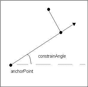
//Finds the closes point to line from (0,0) with angles
//defined by steps of pi/4 (Note all angles in radians)
private void ConstrainAngle()
{
IPoint point = new PointClass();
point.PutCoords(0, 0);
IPoint newPoint = new PointClass();
newPoint.PutCoords(1,0);
for (int i = 0; i < 8; i++)
{
newPoint.ConstrainAngle(i * Math.PI / 4, point,
true);
System.Windows.Forms.MessageBox.Show(newPoint.X + ", " +
newPoint.Y);
}
}
'Finds the closes point to line from (0,0)
with angles
'defined by steps of pi/4 (Note all angles in
radians)
'
Sub TestConstrainAngle()
Dim pApoint As
ESRI.ArcGIS.Geometry.IPoint
Dim pNpoint As
ESRI.ArcGIS.Geometry.IPoint
Dim pi As Double
Dim dAngle As Double
Dim i As Long
pApoint = New
ESRI.ArcGIS.Geometry.Point
pi = 4 *
Math.Atan(1)
dAngle = 0
pApoint.PutCoords(0,
0)
pNpoint = New ESRI.ArcGIS.Geometry.Point
For i = 0 To 7
pNpoint.PutCoords(1, 0)
dAngle = i * pi / 4
pNpoint.ConstrainAngle(dAngle, pApoint, True)
MsgBox("angle = " & i & "*pi/4" & vbCrLf &
pNpoint.X & "," & pNpoint.Y)
Next i
End Sub
ConstrainDistance(double, IPoint)
Projects this point to the perimeter of the circle defined by radius and anchor.
virtual void ConstrainDistance(double constraintRadius, IPoint anchor)Parameters
Remarks
ConstrainDistance

private void ConstrainDistance()
{
  IPoint point = new PointClass();
  point.PutCoords(0, 0);
  IPoint newPoint = new PointClass();
  newPoint.PutCoords(2,2);
  newPoint.ConstrainDistance(Math.PI, point);
  System.Windows.Forms.MessageBox.Show(newPoint.X + ", " + newPoint.Y);
}
Public Sub ConstrainDistanceTest()
Dim pPoint As ESRI.ArcGIS.Geometry.IPoint
Dim pNPoint As ESRI.ArcGIS.Geometry.IPoint
Dim dRadius As Double
pPoint = New ESRI.ArcGIS.Geometry.Point
pPoint.PutCoords(0, 0)
pNPoint = New ESRI.ArcGIS.Geometry.Point
pNPoint.PutCoords(2, 2)
dRadius = 1.4142135623731
pNPoint.ConstrainDistance(dRadius, pPoint)
MsgBox("Radius = " & dRadius & " x,y = " & pNPoint.X & "," & pNPoint.Y)
End Sub
ConstructAlong(ICurve, esriSegmentExtension, double, bool)
Constructs a point distance units along the input curve.
virtual void ConstructAlong(ICurve curve, esriSegmentExtension extension, double distance, bool asRatio)Parameters
curveICurveextensionesriSegmentExtensiondistancedoubleasRatiobool
Remarks
If the Distance parameter is less than zero, or greater than the length of the curve (when asRatio is false), or greater than one (when asRatio is true), then the value of the Extension parameter is used to determine the coordinates of the constructed point. In these cases, the point can be placed somewhere along an embedding geometry, or somewhere along a tangent geometry.
The embedding geometry of a straight line segment is a straight line extending infinitely in both directions. The embedding geometry of a circular arc is a complete circle. The embedding geometry of an elliptic arc is a complete ellipse. A bezier curve has no embedding geometry.
A tangent geometry is always a ray (a straight line extending infinitely in one direction) tangent to the input curve at either its from (start) or to (end) points.
Possible values for the Extension parameter
are:
-------------------------------------------------
esriNoExtension
The constructed point will always be on the input curve. A
distance < 0 will pin the constructed point to the location of
the input curve's from point. A distance > the curve
length (or > 1 when asRatio is true) will pin the location
to the curve's to point.
esriExtendTangentAtFrom If the distance parameter is < 0 then the point is constructed along a ray tangent to the start point of the curve, in a direction away from the curve.
esriExtendTangentAtTo If the distance parameter is greater than the length of the input curve (or > 1 when asRatio is true), then the constructed point is placed along a ray tangent to the end point of the curve, in a direction away from the curve.
esriExtendEmbeddedAtFrom Similar to the tangent option, but uses the embedding geometry instead of the tangent lines.
esriExtendEmbeddedAtTo Similar to the tangent option, but uses the embedding geometry instead of the tangent lines.
esriExtendEmbedded
The point is constructed based on either the start
or end points of the curve.
esriExtendTangents The point is tangential extended from the start or endpoint of the curve.
These values can be combined using the VB Or operator, or the C++ bitwise OR operator.
Example 1:
esriExtendTangentAtFrom Or
esriExtendTangentAtTo
Instead of using
esriExtendTangentsesriExtendTangentAtFrom Or
esriExtendTangentAtTo.

//Select a polyline
in ArcMap and calculate a point along the line
// at 100 distance units
from the start point.
public void
ConstructPointAlongLine(IPolyline pl)
{
ICurve polyLine = pl;
IPoint point1 = ConstructPointAlong(100, polyLine,
esriSegmentExtension.esriNoExtension, false);
System.Windows.Forms.MessageBox.Show("x,y = " + point1.X + "," +
point1.Y);
IPoint point2 = ConstructPointAlong(0.5, polyLine,
esriSegmentExtension.esriNoExtension, true);
System.Windows.Forms.MessageBox.Show("x,y = " + point2.X + "," +
point2.Y);
}
public IPoint
ConstructPointAlong(double distance, ICurve curve,
esriSegmentExtension extension, bool asRatio)
{
IConstructPoint contructionPoint = new PointClass();
contructionPoint.ConstructAlong(curve, extension, distance,
asRatio);
return contructionPoint as IPoint;
}
'+++ Calculate a point along a polyline
'+++ at 100 distance units from the start
point.
Public Sub t_ConstructAlong(ByRef pPolyLine
As ESRI.ArcGIS.Geometry.IPolyline)
On Error GoTo
Errorhandler
Dim pPoint As
ESRI.ArcGIS.Geometry.IPoint
Dim pCrv As
ESRI.ArcGIS.Geometry.ICurve
pCrv = pPolyLine
pPoint =
PtConstructAlong(100, pCrv,
ESRI.ArcGIS.Geometry.esriSegmentExtension.esriNoExtension,
False)
MsgBox("x,y = " &
pPoint.X & "," & pPoint.Y)
pPoint =
PtConstructAlong(0.5, pPolyLine,
ESRI.ArcGIS.Geometry.esriSegmentExtension.esriNoExtension, True) '
Midpoint
MsgBox("x,y = " &
pPoint.X & "," & pPoint.Y)
Exit Sub
Errorhandler:
MsgBox(Err.Number &
"..." & Err.Description)
Exit Sub
End Sub
Public Function PtConstructAlong(ByVal dDist
As Double, ByVal pCurve As ESRI.ArcGIS.Geometry.ICurve, ByVal
extension As ESRI.ArcGIS.Geometry.esriSegmentExtension, ByVal
asRatio As Boolean) As ESRI.ArcGIS.Geometry.IPoint
Dim pCPoint As
ESRI.ArcGIS.Geometry.IConstructPoint
pCPoint = New
ESRI.ArcGIS.Geometry.Point
pCPoint.ConstructAlong(pCurve, extension, dDist, asRatio)
PtConstructAlong =
pCPoint
End Function
ConstructAngleBisector(IPoint, IPoint, IPoint, double, bool)
Constructs a point on the bisector of the angle (from, through, to). When useAcuteAngle is false, the sign of distance will select a point right or left of (from, through, to). Otherwise, the sign of distance will select the acute/obtuse point.
virtual void ConstructAngleBisector(IPoint from, IPoint through, IPoint to, double distance, bool useAcuteAngle)Parameters
Remarks
The method uses a vector geometry to calculate the point. The Smaller Angle is the angle less than PI.
If From , To and Through points are all on a straight line , the point is calculated perpendicular (to the right) of the line.

private void ConstructAngleBisector()
{
IPoint fromPoint = new PointClass();
fromPoint.PutCoords(0, 0);
IPoint throughPoint = new PointClass();
throughPoint.PutCoords(10, 0);
IPoint toPoint = new PointClass();
toPoint.PutCoords(0, 10);
IConstructPoint constructionPoint = new PointClass();
constructionPoint.ConstructAngleBisector(fromPoint, throughPoint, toPoint, 10, true);
IPoint outPutPoint = constructionPoint as IPoint;
System.Windows.Forms.MessageBox.Show("Output point : " + outPutPoint.X + " , " + outPutPoint.Y);
}
Public Sub ConstructAngleBisector()
Dim ptTr As ESRI.ArcGIS.Geometry.IPoint
Dim ptTo As ESRI.ArcGIS.Geometry.IPoint
Dim ptFrom As ESRI.ArcGIS.Geometry.IPoint
Dim pConstructLine As ESRI.ArcGIS.Geometry.IConstructLine
Dim pOutPutLine As ESRI.ArcGIS.Geometry.ILine
Dim Pi As Double
Pi = 4 * Math.Atan(1)
ptTr = New ESRI.ArcGIS.Geometry.Point
ptTo = New ESRI.ArcGIS.Geometry.Point
ptFrom = New ESRI.ArcGIS.Geometry.Point
pConstructLine = New ESRI.ArcGIS.Geometry.Line
ptTr.PutCoords(0, 0)
ptTo.PutCoords(0, 10)
ptFrom.PutCoords(10, 0)
pConstructLine.ConstructAngleBisector(ptFrom, ptTr, ptTo, 10, True)
pOutPutLine = pConstructLine 'QI
Debug.Print(pOutPutLine.Length)
'Angle from the XAxis
Debug.Print((180 * pOutPutLine.Angle) / Pi)
End Sub
ConstructAngleDistance(IPoint, double, double)
Constructs a point at a specified angle (in radians) from the horizontal axis and a specified distance away from the input point.
virtual void ConstructAngleDistance(IPoint p, double inAngle, double distance)Parameters
Remarks
Angle in radians and distance in map units. The angle is measured counter-clockwise from the horizontal line and can be negative. If the distance is negative then the opposite direction is assumed (same as angle + PI). 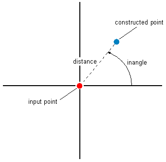
// select a point in ArcMap and calculate a new point with the
// angle of 45 degrees and distance on 250 map units.
public void ConstructAngleDistance()
{
IMxDocument mxDocument = m_application.Document as IMxDocument;
IMap map = mxDocument.FocusMap;
ISelection featureSelection = map.FeatureSelection;
IEnumFeature featureEnumerator = featureSelection as IEnumFeature;
featureEnumerator.Reset();
IFeature currentFeature = featureEnumerator.Next();
double distance = 250;
double angle = 45;
while (currentFeature != null)
{
if (currentFeature.Shape.GeometryType == esriGeometryType.esriGeometryPoint)
{
IPoint startPoint = currentFeature.Shape as IPoint;
System.Windows.Forms.MessageBox.Show("Start Point: " + startPoint.X + ", " + startPoint.Y + "\n" +
"Angle: " + angle + "\n" + "Distance: " + distance);
IPoint point = _ConstructAngleDistance(startPoint, angle, distance);
System.Windows.Forms.MessageBox.Show("x,y = " + point.X + "," + point.Y);
}
currentFeature = featureEnumerator.Next();
}
}
private IPoint _ConstructAngleDistance(IPoint point, double angle, double distance)
{
//Convert the angle degrees to radians
double angleRad = angle * 2 * Math.PI / 360;
IConstructPoint construcionPoint = new PointClass();
construcionPoint.ConstructAngleDistance(point, angleRad, distance);
return construcionPoint as IPoint;
}
'+++ select a point in ArcMap and calculate a new point with the
'+++ angle of 45 degrees and distance on 100 map units.
Public Sub t_ConstructAngleDistance(ByRef pMXDoc As ESRI.ArcGIS.ArcMapUI.IMxDocument)
On Error GoTo Errorhandler
Dim pEnumFeat As ESRI.ArcGIS.Geodatabase.IEnumFeature
Dim pFeature As ESRI.ArcGIS.Geodatabase.IFeature
Dim pSelection As ESRI.ArcGIS.Carto.ISelection
Dim pMap As ESRI.ArcGIS.Carto.IMap
Dim pPoint As ESRI.ArcGIS.Geometry.IPoint
Dim pStart As ESRI.ArcGIS.Geometry.IPoint
Dim dDist As Long
Dim dAngle As Long
pMap = pMXDoc.FocusMap
pSelection = pMap.FeatureSelection
pEnumFeat = pSelection
pEnumFeat.Reset()
pFeature = pEnumFeat.Next
dDist = 250
dAngle = 45
While Not pFeature Is Nothing
If pFeature.Shape.GeometryType = ESRI.ArcGIS.Geometry.esriGeometryType.esriGeometryPoint Then
pStart = pFeature.Shape
Debug.Print(1, "Start Point:" & pStart.X & "," & pStart.Y & vbCrLf & _
"Angle:" & dAngle & vbCrLf & "Distance:" & dDist)
pPoint = PtConstructAngleDistance(pStart, dAngle, dDist)
Debug.Print(1, "x,y = " & pPoint.X & "," & pPoint.Y & vbCrLf)
End If
pFeature = pEnumFeat.Next
End While
Exit Sub
Errorhandler:
MsgBox(Err.Number & "..." & Err.Description)
Exit Sub
End Sub
Public Function PtConstructAngleDistance(ByVal pPoint As ESRI.ArcGIS.Geometry.IPoint, ByVal dAngle As Long, ByVal dDist As Long) As ESRI.ArcGIS.Geometry.IPoint
Const PI = 3.14159265358979
Dim dAngleRad As Double
Dim pCPoint As ESRI.ArcGIS.Geometry.IConstructPoint
pCPoint = New ESRI.ArcGIS.Geometry.Point
dAngleRad = dAngle * 2 * PI / 360 'Convert the angle degrees to radians
pCPoint.ConstructAngleDistance(pPoint, dAngleRad, dDist)
PtConstructAngleDistance = pCPoint
End Function
ConstructAngleIntersection(IPoint, double, IPoint, double)
Constructs the point of intersection between two lines defined by the input points and angles (in radians).
virtual void ConstructAngleIntersection(IPoint p1, double angle1, IPoint p2, double angle2)Parameters
Remarks
Angles are specified as geometric angles measured counterclockwise from the positive x axis of the Cartesian coordinate system. All angles are specified in radians .
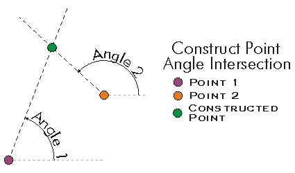
//This method constructs a new point as intersection of 2 lines
public void ConstructAngleIntersection()
{
IPoint fromPoint = new PointClass();
fromPoint.PutCoords(0, 0);
IPoint toPoint = new PointClass();
toPoint.PutCoords(100, 0);
double angle1Rad = 45 * 2 * Math.PI / 360;
double angle2Rad = 135 * 2 * Math.PI / 360;
IConstructPoint constructionPoint = new PointClass();
constructionPoint.ConstructAngleIntersection(fromPoint, angle1Rad, toPoint, angle2Rad);
IPoint outPutPoint = constructionPoint as IPoint;
System.Windows.Forms.MessageBox.Show("Output point : " + outPutPoint.X + " , " + outPutPoint.Y);
}
'+++ Construct a new point as intersection of 2 lines
Public Sub t_ConstructAngleIntersection()
On Error GoTo Errorhandler
Dim pPoint1 As ESRI.ArcGIS.Geometry.IPoint
Dim pPoint2 As ESRI.ArcGIS.Geometry.IPoint
Dim pPoint As ESRI.ArcGIS.Geometry.IPoint
Dim dAngle1 As Long
Dim dAngle2 As Long
pPoint1 = New ESRI.ArcGIS.Geometry.Point
pPoint2 = New ESRI.ArcGIS.Geometry.Point
pPoint1.PutCoords(0, 0)
pPoint2.PutCoords(100, 0)
dAngle1 = 45
dAngle2 = 135
pPoint = ptConstructAngleIntersection(pPoint1, dAngle1, pPoint2, dAngle2)
MsgBox("x,y = " & pPoint.X & "," & pPoint.Y)
Exit Sub
Errorhandler:
MsgBox(Err.Number & "..." & Err.Description)
Exit Sub
End Sub
Public Function ptConstructAngleIntersection(ByVal pPt1 As ESRI.ArcGIS.Geometry.IPoint, ByVal dAngle1 As Long, ByVal pPt2 As ESRI.ArcGIS.Geometry.IPoint, ByVal dAngle2 As Long) As ESRI.ArcGIS.Geometry.IPoint
Const PI As Double = 3.14159265358979
Dim dAngleRad1 As Double
Dim dAngleRad2 As Double
Dim pCPoint As ESRI.ArcGIS.Geometry.IConstructPoint
pCPoint = New ESRI.ArcGIS.Geometry.Point
dAngleRad1 = dAngle1 * 2 * PI / 360 ' Conversion degrees to radians
dAngleRad2 = dAngle2 * 2 * PI / 360
pCPoint.ConstructAngleIntersection(pPt1, dAngleRad1, pPt2, dAngleRad2)
ptConstructAngleIntersection = pCPoint
End Function
ConstructAverage(IPointCollection, esriGeometryAttributes)
Constructs the geometric average of the input point collection. Optionally uses the specified attribute as a source of weights on the locations of the points.
virtual void ConstructAverage(IPointCollection Points, esriGeometryAttributes attributeType)Parameters
PointsIPointCollectionattributeTypeesriGeometryAttributes
Remarks
If attributeType is esriAttributeNone then the average point location is computed; otherwise the attribute specified by attributeType serves as a weight. Points whose weight attribute is NaN are ignored (a weight of 0 has a similar affect). The resulting point will have the (weighted) average for all their attributes. However this does not apply to ID's; no average is calculated for them in any case; but thay can be used as weight.
Only the following attributeType values are permitted: esriAttributeNone, esriAttributeZ, esriAttributeM, esriAttributeID.
//This example demonstrates how to use the ConstructAverage method
private void ConstructAverage_Example()
{
IPointCollection4 pointCollection = new MultipointClass();
object Missing = Type.Missing;
//Create a MAware and a ZAware multipoint
IPoint[] points = new IPoint[4];
for(int i = 0; i < 4; i++)
{
points[i]= new PointClass();
}
points[0].PutCoords(0, 0);
points[0].Z = 10;
points[0].M = 10;
points[1].PutCoords(0, 5);
points[1].Z = 10;
points[1].M = 10;
points[2].PutCoords(5, 5);
points[2].Z = 20;
points[2].M = 20;
points[3].PutCoords(5, 0);
points[3].Z = 10;
points[3].M = 20;
IGeometryBridge geomBridge = new GeometryEnvironmentClass();
geomBridge.AddPoints(pointCollection, ref points);
IZAware zAwareCollection = pointCollection as IZAware;
zAwareCollection.ZAware = true;
IMAware mAwareCollection = pointCollection as IMAware;
mAwareCollection.MAware = true;
IConstructPoint2 constructionPoint = new PointClass();
//Construct the average point with esriAttributeM
constructionPoint.ConstructAverage(pointCollection, esriGeometryAttributes.esriAttributeM);
IPoint outPutPoint1 = constructionPoint as IPoint;
System.Windows.Forms.MessageBox.Show("Output point with esriAttributeM: " + outPutPoint1.X + " , " + outPutPoint1.Y + " , " + outPutPoint1.M);
//Construct the average point with esriAttributeZ
constructionPoint.ConstructAverage(pointCollection, esriGeometryAttributes.esriAttributeZ);
IPoint outPutPoint2 = constructionPoint as IPoint;
System.Windows.Forms.MessageBox.Show("Output point with esriAttributeZ: " + outPutPoint2.X + " , " + outPutPoint2.Y + " , " + outPutPoint2.Z);
}
'This example demonstrates how to use the ConstructAverage method
Sub ConstructAverage_Example()
Dim pPoints(0 To 3) As IPoint, pPointcol As IPointCollection4
Dim pZawareCol As IZAware, pMawareCol As IMAware
Dim pPoint As IPoint, pconstpoint2 As IConstructPoint2
'Create a MAware and a ZAware multipoint
pPoints(0) = New Point
pPoints(1) = New Point
pPoints(2) = New Point
pPoints(3) = New Point
pPoints(0).PutCoords(0, 0)
pPoints(1).PutCoords(0, 5)
pPoints(2).PutCoords(5, 5)
pPoints(3).PutCoords(5, 0)
pPoints(0).Z = 10
pPoints(1).Z = 10
pPoints(2).Z = 20
pPoints(3).Z = 10
pPoints(0).M = 10
pPoints(1).M = 10
pPoints(2).M = 20
pPoints(3).M = 10
pPointcol = New Multipoint
Dim pGeometryBridge As IGeometryBridge
pGeometryBridge = New GeometryEnvironment
pGeometryBridge.AddPoints(pPointcol, pPoints)
pZawareCol = pPointcol
pZawareCol.ZAware = True
pMawareCol = pPointcol
pMawareCol.MAware = True
pconstpoint2 = New Point
'** Construct the average point with esriAttributeM
pconstpoint2.ConstructAverage(pPointcol, esriGeometryAttributes.esriAttributeM)
pPoint = pconstpoint2
Debug.Print("***** esriAttributeM *****")
Debug.Print(pPoint.X & " , " & pPoint.Y & " , " & pPoint.M)
'** Construct the average point with esriAttributeZ
pconstpoint2 = New Point
pconstpoint2.ConstructAverage(pPointcol, esriGeometryAttributes.esriAttributeZ)
pPoint = pconstpoint2
Debug.Print("***** esriAttributeZ *****")
Debug.Print(pPoint.X & " , " & pPoint.Y & " , " & pPoint.Z)
End Sub
ConstructDeflection(ILine, double, double)
Constructs a point in the polar coordinate system defined by baseLine and its 'from' point. The angle is in radians.
virtual void ConstructDeflection(ILine baseLine, double distance, double inAngle)Parameters
Remarks

//Constructs a point from the baseline from (0,0) to (1,1)
// with the deflection angle of 45 degrees (PI/4 radians).
public void ConstructDeflection()
{
IPoint fromPoint = new PointClass();
fromPoint.PutCoords(0, 0);
IPoint toPoint = new PointClass();
toPoint.PutCoords(1, 1);
ILine line = new LineClass();
line.PutCoords(fromPoint, toPoint);
double distance = 1.4142135623731;
double angle = Math.PI / 4;
IConstructPoint constructionPoint = new PointClass();
constructionPoint.ConstructDeflection(line, distance, angle);
IPoint point = constructionPoint as IPoint;
System.Windows.Forms.MessageBox.Show("x,y = " + point.X + ", " + point.Y);
}
'+++ Constructs a point from the baseline from (0,0) to (1,1)
'+++ with the deflection angle of 45 degrees (PI/4 radians).
Public Sub t_ConstructDeflection()
On Error GoTo Errorhandler
Dim pPointFrom As IPoint
Dim pPointTo As IPoint
Dim pLine As ILine
Dim pPoint As IPoint
Dim pCPoint As IConstructPoint
Dim dDist As Double
Dim dAngle As Double
Dim pi As Double
pPointFrom = New Point
pPointTo = New Point
pCPoint = New Point
pPoint = New Point
pLine = New Line
pPointFrom.PutCoords(0, 0)
pPointTo.PutCoords(1, 1)
pLine.PutCoords(pPointFrom, pPointTo)
dDist = 1.4142135623731
pi = 4 * Math.Atan(1)
dAngle = pi / 4
pCPoint.ConstructDeflection(pLine, dDist, dAngle)
pPoint = pCPoint
MsgBox("x,y = " & pPoint.X & "," & pPoint.Y)
Exit Sub
Errorhandler:
MsgBox(Err.Number & "..." & Err.Description)
Exit Sub
End Sub
ConstructDeflectionIntersection(ILine, double, double, bool)
Constructs the point of intersection of two rays with origins at the endpoints of the base line and the specified angles (in radians). If onRightSide is true, this work will be done to the right of the base line, otherwise to the left.
virtual void ConstructDeflectionIntersection(ILine baseLine, double startAngle, double endAngle, bool OnRightSide)Parameters
Remarks
the bRightSide flag can be used to always force the constructed point to be on the right side of the baseline.
The startAngle is the angle (in radians) from the baseline's startpoint of the line to the constructed point. The endAngle is the angle (in radians) from the baseline's endpoint to the constructed point.
Both angles have to be > 0 and < 2 PI radians. Their sum must also be less than PI radians.

//Constructs a point from the baseline from (0,0) to (1,1)
//with the deflection angle of 45 degrees (PI/4 radians).
public void ConstructDeflectionIntersection()
{
  IPoint fromPoint = new PointClass();
  fromPoint.PutCoords(0, 0);
  IPoint toPoint = new PointClass();
  toPoint.PutCoords(1, 1);
  ILine line = new LineClass();
  line.PutCoords(fromPoint, toPoint);
  double startAngle = Math.PI / 4;
  double endAngle = Math.PI / 4;
  IConstructPoint constructionPoint = new PointClass();
  constructionPoint.ConstructDeflectionIntersection(line, startAngle, endAngle, false);
  IPoint point = constructionPoint as IPoint;
  System.Windows.Forms.MessageBox.Show("x,y = " + point.X + ", " + point.Y);
}
'+++ Constructs a point as the intersection
of 2 lines with angles
'+++ dStartAngle (from the startpoint of the
line) and dEndAngle.
'+++ The flag to force the line to the right
side is turned off.
Public Sub
t_ConstructDeflectionIntersection()
Dim pPointFrom As
ESRI.ArcGIS.Geometry.IPoint
Dim pPointTo As
ESRI.ArcGIS.Geometry.IPoint
Dim pLine As
ESRI.ArcGIS.Geometry.ILine
Dim pPoint As
ESRI.ArcGIS.Geometry.IPoint
Dim pCPoint As
ESRI.ArcGIS.Geometry.IConstructPoint
Dim dStartAngle As
Double
Dim dEndAngle As
Double
Dim pi As Double
pPointFrom = New
ESRI.ArcGIS.Geometry.Point
pPointTo = New
ESRI.ArcGIS.Geometry.Point
pCPoint = New
ESRI.ArcGIS.Geometry.Point
pPoint = New
ESRI.ArcGIS.Geometry.Point
pLine = New
ESRI.ArcGIS.Geometry.Line
pPointFrom.PutCoords(0, 0)
pPointTo.PutCoords(1,
0)
pLine.PutCoords(pPointFrom, pPointTo)
pi = 4 *
Math.Atan(1)
dStartAngle = pi / 4
dEndAngle = pi / 4
pCPoint.ConstructDeflectionIntersection(pLine, dStartAngle,
dEndAngle, False)
pPoint = pCPoint
MsgBox("x,y = " &
pPoint.X & "," & pPoint.Y)
End Sub
ConstructOffset(ICurve, esriSegmentExtension, double, bool, double)
Constructs a point distance units along the input curve and offset units perpendicularly away from it.
virtual void ConstructOffset(ICurve curve, esriSegmentExtension extension, double distance, bool asRatio, double Offset)Parameters
curveICurveextensionesriSegmentExtensiondistancedoubleasRatioboolOffsetdouble
Remarks
A positive Offset distance will create a point on the right side of the curve and a negative offset will create a point on the left side of the curve. 
Set the asRatio flag to be True if you want the distance to be a ratio of the curve length. If set to True, then a distance of 0.5 will be equal to half of the curve length (i.e. 50%).
//This example demonstrates how to use IConstructPoint.ConstructOffset method
private void ConstructOffset()
{
IPoint[] points = new IPoint[4];
for (int i = 0; i < 4; i++)
{
points[i] = new PointClass();
}
points[0].PutCoords(0, 0);
points[1].PutCoords(10, 0);
points[2].PutCoords(20, 0);
points[3].PutCoords(30, 0);
IPointCollection polyline = new Polyline();
//helper class to solve C-Style Array usage in COM classes
IGeometryBridge geometryBride = new GeometryEnvironmentClass();
geometryBride.AddPoints(polyline as IPointCollection4, ref points);
IConstructPoint constructionPoint = new PointClass();
//The spatial reference should be set on the new point here (Code skipped)
//Example 1: Distance No ratio, Positive offset
constructionPoint.ConstructOffset(polyline as ICurve, esriSegmentExtension.esriNoExtension, 15, false, 5);
IPoint outPutPoint1 = constructionPoint as IPoint;
System.Windows.Forms.MessageBox.Show("Output point : " + outPutPoint1.X + " , " + outPutPoint1.Y);
//Output point : 15 , -5
//*********************************************
//Example 2: Distance as ratio, Positive offset
constructionPoint.ConstructOffset(polyline as ICurve, esriSegmentExtension.esriNoExtension, 0.5, true, 5);
IPoint outPutPoint2 = constructionPoint as IPoint;
System.Windows.Forms.MessageBox.Show("Output point : " + outPutPoint2.X + " , " + outPutPoint2.Y);
//Output point : 15 , -5
//*********************************************
//Example 3: Distance No ratio, Negative offset
constructionPoint.ConstructOffset(polyline as ICurve, esriSegmentExtension.esriNoExtension, 15, false, -5);
IPoint outPutPoint3 = constructionPoint as IPoint;
System.Windows.Forms.MessageBox.Show("Output point : " + outPutPoint3.X + " , " + outPutPoint3.Y);
//Output point : 15 , 5
}
'This example demonstrates how to use IConstructPoint::ConstructOffset
Sub ConstructOffset()
Dim ptc As IPointCollection, pt(3) As IPoint, i As Long
Dim pconsPoint As IConstructPoint, ptout As IPoint
ptc = New Polyline
'The spatial reference should be set on the polyline here (Code skipped)
For i = 0 To 3
pt(i) = New Point
Next
pt(0).PutCoords(0, 0)
pt(1).PutCoords(10, 0)
pt(2).PutCoords(20, 0)
pt(3).PutCoords(30, 0)
ptc.AddPoints(4, pt(0))
'The spatial reference should be set on the new point here (Code skipped)
'*********************************************
'Example 1: Distance No ratio, Positive offset
pconsPoint = New Point
pconsPoint.ConstructOffset(ptc, esriSegmentExtension.esriNoExtension, 15, False, 5)
ptout = pconsPoint
Debug.Print("Output point : " & ptout.X & " , " & ptout.Y)
'Output point : 15 , -5
'*********************************************
'Example 2: Distance as ratio, Positive offset
pconsPoint = New Point
pconsPoint.ConstructOffset(ptc, esriSegmentExtension.esriNoExtension, 0.5, True, 5)
ptout = pconsPoint
Debug.Print("Output point : " & ptout.X & " , " & ptout.Y)
'Output point : 15 , -5
'*********************************************
'Example 3: Distance No ratio, Negative offset
pconsPoint = New Point
pconsPoint.ConstructOffset(ptc, esriSegmentExtension.esriNoExtension, 15, False, -5)
ptout = pconsPoint
Debug.Print("Output point : " & ptout.X & " , " & ptout.Y)
'Output point : 15 , 5
End Sub
ConstructParallel(ISegment, esriSegmentExtension, IPoint, double)
Constructs a point distance units from start, parallel to the tangent at the point nearest to start on the (extended) segment.
virtual void ConstructParallel(ISegment Segment, esriSegmentExtension extension, IPoint start, double distance)Parameters
SegmentISegmentextensionesriSegmentExtensionstartIPointdistancedouble
Remarks

//The example shows how to construct a point parallel to the first segment
//of a selected polyline. Use ArcMap and the Object Editor to select the
//polyline.
public void ConstructPointParallelToLine(IMxDocument mxDocument)
{
IMap map = mxDocument.FocusMap;
IEnumFeature selectedFeatures = map.FeatureSelection as IEnumFeature;
selectedFeatures.Reset();
IFeature currentFeature = selectedFeatures.Next();
IConstructPoint constructionPoint = new PointClass();
while (currentFeature != null)
{
if (currentFeature.Shape.GeometryType == esriGeometryType.esriGeometryPolyline)
{
IGeometryCollection geometryCollection = currentFeature.Shape as IGeometryCollection;
ISegmentCollection segmentCollection = geometryCollection.get_Geometry(0) as ISegmentCollection;
ISegment segment = segmentCollection.get_Segment(0);
IPoint fromPoint = new PointClass();
segment.QueryFromPoint(fromPoint);
//add 10 to the x coordinate in order to get a diffrent point for this example
fromPoint.X = fromPoint.X + 10;
constructionPoint.ConstructParallel(segment, esriSegmentExtension.esriNoExtension, fromPoint, segment.Length / 2);
IPoint outPutPoint = constructionPoint as IPoint;
System.Windows.Forms.MessageBox.Show("Output point : " + outPutPoint.X + " , " + outPutPoint.Y);
}
currentFeature = selectedFeatures.Next();
}
}
' The example shows how to construct a point parallel to the first segment
' of a selected polyline. Use ArcMap and the Object Editor to select the
' polyline.
Public Sub t_constructParallel(ByVal pApp As ESRI.ArcGIS.Framework.IApplication)
Dim pID As New ESRI.ArcGIS.esriSystem.UID
pID = "esriEditor.editor"
Dim pEditor As ESRI.ArcGIS.Editor.IEditor
pEditor = pApp.FindExtensionByCLSID(pID)
If pEditor.SelectionCount > 1 Then
MsgBox("select one polyline")
Exit Sub
End If
Dim pEnumFeat As ESRI.ArcGIS.Geodatabase.IEnumFeature
Dim pFeature As ESRI.ArcGIS.Geodatabase.IFeature
Dim i As Long
pEnumFeat = pEditor.EditSelection
Dim pSeg As ESRI.ArcGIS.Geometry.ISegment
Dim pGeoColl As ESRI.ArcGIS.Geometry.IGeometryCollection
Dim pPoint As ESRI.ArcGIS.Geometry.IPoint
pPoint = New ESRI.ArcGIS.Geometry.Point
Dim pCPoint As ESRI.ArcGIS.Geometry.IConstructPoint
pCPoint = New ESRI.ArcGIS.Geometry.Point
Dim pThroughPoint As ESRI.ArcGIS.Geometry.IPoint
pThroughPoint = New ESRI.ArcGIS.Geometry.Point
pFeature = pEnumFeat.Next
While Not pFeature Is Nothing
If pFeature.Shape.GeometryType = ESRI.ArcGIS.Geometry.esriGeometryType.esriGeometryPolyline Then
pGeoColl = pFeature.Shape
Dim pSegColl As ESRI.ArcGIS.Geometry.ISegmentCollection
pSegColl = pGeoColl.Geometry(0)
pSeg = pSegColl.Segment(0)
pSeg.QueryFromPoint(pThroughPoint)
pThroughPoint.X = pThroughPoint.X + 10
pCPoint.ConstructParallel(pSeg, ESRI.ArcGIS.Geometry.esriSegmentExtension.esriNoExtension, pThroughPoint, pSeg.Length / 2)
pPoint = pCPoint
MsgBox(pPoint.X & "," & pPoint.Y)
End If
pFeature = pEnumFeat.Next
End While
End Sub
ConstructPerpendicular(ISegment, esriSegmentExtension, IPoint, double, bool)
Constructs a point 'distance' units from p and lying along the line normal to base and passing through p.
virtual void ConstructPerpendicular(ISegment @base, esriSegmentExtension extension, IPoint p, double distance, bool bUseLineOrientation)Parameters
baseISegmentextensionesriSegmentExtensionpIPointdistancedoublebUseLineOrientationbool
Remarks

ConstructThreePointResection(IPoint, double, IPoint, double, IPoint, out double)
Constructs the point of observation from which two signed angles between three points were measured; returns an angle which can help establish the confidence of the observation location: A small angle indicates greater uncertainty in the location.
virtual void ConstructThreePointResection(IPoint point1, double angleP1P2, IPoint point2, double angleP2P3, IPoint point3, out double arcAngle)Parameters
Remarks
Given three points and two angles measured
from the constructed point.

Note that there is no unique solution if all three points are on
the same circle.
Private Shared Sub t_ConstructThreePointResection()
On Error GoTo Errorhandler
Dim pPoint As IPoint
Dim pCPoint As IConstructPoint
Dim pPoint1 As IPoint
Dim pPoint2 As IPoint
Dim pPoint3 As IPoint
Dim dAngle1 As Double
Dim dAngle2 As Double
pCPoint = New Point
pPoint = New Point
pPoint1 = New Point
pPoint2 = New Point
pPoint3 = New Point
pPoint1.PutCoords(0, 1)
pPoint2.PutCoords(2, 2)
pPoint3.PutCoords(1, 0)
dAngle1 = Math.PI / 4
dAngle2 = Math.PI / 4
pCPoint.ConstructThreePointResection(pPoint1, dAngle1, pPoint2, dAngle2, pPoint3, Math.PI / 2)
pPoint = pCPoint
MsgBox("x,y = " & pPoint.X & "," & pPoint.Y)
Exit Sub
Errorhandler:
MsgBox(Err.Number & "..." & Err.Description)
Exit Sub
End Sub
ConstructUnion(IEnumGeometry)
Defines this geometry to be the union of the inputs. More efficient for unioning multiple geometries than calling Union repeatedly.
virtual void ConstructUnion(IEnumGeometry geometries)Parameters
geometriesIEnumGeometry
Remarks
ITopologicalOperator methods must be applied on high-level geometries only. High-Level geometries are point, multipoint, polyline and polygon. To use this method with low-level geometries such as segments (Line, Circular Arc, Elliptic Arc, Bézier Curve), paths or rings, they must be wrapped into high-level geometries types.
This method does not support GeometryBags.
Temproray files might be created. If environment variable
"ARCTMPDIR" exists, then the files are written to the path,
otherwise written to current directory or system temp
directory.
//The following code shows to wrap a line segment into a polyline in C#
//Assume a line (line1 as ILine) is already created
object obj = Type.Missing;
ISegmentCollection segCollection = new PolylineClass() as ISegmentCollection;
segCollection.AddSegment((ISegment)line1, ref obj, ref obj);
//Set the spatial reference on the new polyline
//The spatial reference is not transfered automatically from the segments
IGeometry geom = segCollection as IGeometry;
geom.SpatialReference = spatialRef;
//Can now be used with ITopologicalOperator methods
ConstructUnionEx(IEnumGeometry, bool)
Defines this geometry to be the union of the inputs, with the option for non-planary result.
virtual void ConstructUnionEx(IEnumGeometry pEnum, bool bNonPlanar)Parameters
pEnumIEnumGeometrybNonPlanarbool
Contains(IGeometry)
Indicates if this geometry contains the other geometry.
virtual bool Contains(IGeometry other)Parameters
otherIGeometry
Returns
Remarks
Only geometries that support the IRelationalOperator interface can be used as input geometries.
If geometry1 Contains geometry2, then geometry2 is Within geometry1.
An empty geometry does not contain another geometry. On the other hand, an empty geometry is contained in another geometry, unless the other geometry is empty.
Contains examples. Only "true" relationships are showed in this picture.

ContainsEx(IGeometry, esriSpatialRelationExEnum)
Indicates if this geometry contains the other geometry, optionally using Celementini's definition.
virtual bool ContainsEx(IGeometry pOther, esriSpatialRelationExEnum Relation)Parameters
pOtherIGeometryRelationesriSpatialRelationExEnum
Returns
ConvexHull()
Constructs the convex hull of this geometry.
virtual IGeometry ConvexHull()Returns
Remarks
ITopologicalOperator methods must be applied on high-level geometries only. High-Level geometries are point, multipoint, polyline and polygon. To use this method with low-level geometries such as segments (Line, Circular Arc, Elliptic Arc, Bézier Curve), paths or rings, they must be wrapped into high-level geometries types.
This method does not support GeometryBags.
ConvexHull method does not deal with Z attribute now.

CreateMGRS(int, bool, esriMGRSModeEnum)
Returns the MGRS/USNG description of a point.
virtual string CreateMGRS(int numDigits, bool round, esriMGRSModeEnum mode)Parameters
numDigitsintroundboolmodeesriMGRSModeEnum
Returns
Crosses(IGeometry)
Indicates if the two geometries intersect in a geometry of lesser dimension.
virtual bool Crosses(IGeometry other)Parameters
otherIGeometry
Returns
Remarks
Only geometries that support the IRelationalOperator interface can be used as input geometries.
Cross only applies to polyline/polyline, polyline/polygon, or polygon/polyline relations.
If either one of the geometries is empty, the geometries do not cross.
Crosses examples. Only "true" relationships are showed in this picture.

Cut(IPolyline, out IGeometry, out IGeometry)
Splits this geometry into a part left of the cutting polyline, and a part right of it.
virtual void Cut(IPolyline cutter, out IGeometry leftGeom, out IGeometry rightGeom)Parameters
Remarks
ITopologicalOperator methods must be applied on high-level geometries only. High-Level geometries are point, multipoint, polyline and polygon. To use this method with low-level geometries such as segments (Line, Circular Arc, Elliptic Arc, Bézier Curve), paths or rings, they must be wrapped into high-level geometries types.
When a polyline/polygon is cut, it is split where it intersects the cutter polyline. Each piece is classified as ‘left of’ or ‘right of’ the cutter. This classification is based on the orientation of the cutter line. Parts of the target polyline that do not intersect the cutting polyline are returned as part of the ‘right of’ result for that input polyline. If a geometry is not cut, the left geometry will be empty.
When using a multi-part polyline to cut a single ring of a polyline, the orientation of the polyline paths is important. The cut piece of the ring must be on the same side of each cutting path as defined by the orientation of each path.
This method does not support GeometryBags.

//The following code shows to wrap a line segment into a polyline in C#
//Assume a line (line1 as ILine) is already created
object obj = Type.Missing;
ISegmentCollection segCollection = new PolylineClass() as ISegmentCollection;
segCollection.AddSegment((ISegment)line1, ref obj, ref obj);
//Set the spatial reference on the new polyline
//The spatial reference is not transfered automatically from the segments
IGeometry geom = segCollection as IGeometry;
geom.SpatialReference = spatialRef;
//Can now be used with ITopologicalOperator methods
Deserialize(IXMLSerializeData)
Deserializes an object from XML.
virtual void Deserialize(IXMLSerializeData data)Parameters
dataIXMLSerializeData
Difference(IGeometry)
Constructs the geometry containing points from this geometry but not the other geometry.
virtual IGeometry Difference(IGeometry other)Parameters
otherIGeometry
Returns
Remarks
ITopologicalOperator methods must be applied on high-level geometries only. High-Level geometries are point, multipoint, polyline and polygon. To use this method with low-level geometries such as segments (Line, Circular Arc, Elliptic Arc, Bézier Curve), paths or rings, they must be wrapped into high-level geometries types.
This method does not support GeometryBags.
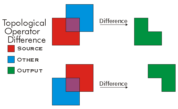
//The following code shows to wrap a line segment into a polyline in C#
//Assume a line (line1 as ILine) is already created
object obj = Type.Missing;
ISegmentCollection segCollection = new PolylineClass() as ISegmentCollection;
segCollection.AddSegment((ISegment)line1, ref obj, ref obj);
//Set the spatial reference on the new polyline
//The spatial reference is not transfered automatically from the segments
IGeometry geom = segCollection as IGeometry;
geom.SpatialReference = spatialRef;
//Can now be used with ITopologicalOperator methods
DifferenceEx(IGeometry, bool)
defined for (multi)points and polylines.
virtual IGeometry DifferenceEx(IGeometry other, bool bNonPlanar)Parameters
Returns
Dimension
virtual esriGeometryDimension Dimension { get; }Returns
Disjoint(IGeometry)
Indicates if the two geometries share no points in common. Negate this result to compute the Intersect relation.
virtual bool Disjoint(IGeometry other)Parameters
otherIGeometry
Returns
Remarks
Only geometries that support the IRelationalOperator interface can be used as input geometries.
Two geometries are disjoint if either one is empty.
Disjoint example. Only "true" relationships are showed in this picture.

Disjoint3D(IGeometry)
Indicates if the two geometries share no points in common. Negate this result to compute the Intersect relation.
virtual bool Disjoint3D(IGeometry pOther)Parameters
pOtherIGeometry
Returns
DropMs()
Sets all the M values to a non-valid number (NaN).
virtual void DropMs()DropPointIDs()
Unsets all PointID values without changing awareness. Only works if geometry is aware of PointIDs.
virtual void DropPointIDs()DropZs()
Sets all the Z values to a non-valid number (NaN).
virtual void DropZs()Envelope
virtual IEnvelope Envelope { get; }Returns
Equals(IGeometry)
Indicates if the two geometries are of the same type and define the same set of points in the plane.
virtual bool Equals(IGeometry other)Parameters
otherIGeometry
Returns
Remarks
Only geometries that support the IRelationalOperator interface can be used as input geometries. GeometryBags are not supported. IRelationalOperator::Equals delegates to ITopologicalOperatorSymmetricDifference and returns true when that method returns an empty geometry; M's and Z's are ignored. Please use IClone::IsEqual if M's and Z's need to be compared.
IClone::IsEqual simply iterates over each segment in each geometry, in index order, and compares their types and coordinates (but using the spatial reference's cluster tolerances to determine equality of coordinates).
Only "true" relationships are showed in this picture.

The RCW for the IRelationalOperator inherits from System.Object, as do all reference types in .NET. The System.Object type has a method called Equals, which results in the IRelationalOperator RCW having two overloaded versions of the Equals method. Ensure that you are not using the Equals method inherited from the System.Object class by mistake, by making sure you pass in an IGeometry reference to the Equals method. For example, the following extract of code from a C# console application demonstrates calling Equals correctly.
ESRI.ArcGIS.Geometry.IPoint pt1 = new ESRI.ArcGIS.Geometry.PointClass();
pt1.PutCoords(5, 5);
ESRI.ArcGIS.Geometry.IPoint pt2 = new ESRI.ArcGIS.Geometry.PointClass();
pt2.PutCoords(5, 5);
ESRI.ArcGIS.Geometry.IRelationalOperator rel1 = pt1 as ESRI.ArcGIS.Geometry.IRelationalOperator;
ESRI.ArcGIS.Geometry.IGeometry geom2 = pt2 as ESRI.ArcGIS.Geometry.IGeometry;
bool relEqual = rel1.Equals(pt2); //calling IRelationalOperator::Equals
Console.WriteLine("Equal: " + relEqual.ToString());
bool netEqual =  rel1.Equals(pt2 as object);  //calling Object::Equals
Console.WriteLine("Equal: " + netEqual.ToString());
GeoNormalize()
virtual void GeoNormalize()GeoNormalizeFromLongitude(double)
virtual void GeoNormalizeFromLongitude(double Longitude)Parameters
Longitudedouble
GeometryType
virtual esriGeometryType GeometryType { get; }Returns
GetClassID(out Guid)
virtual void GetClassID(out Guid pClassID)Parameters
pClassIDGuid
GetDDFromCoords(int)
Returns the decimal degrees description of a point.
virtual string GetDDFromCoords(int precision)Parameters
precisionint
Returns
GetDDMFromCoords(int)
Returns the degrees decimal minutes description of a point.
virtual string GetDDMFromCoords(int precision)Parameters
precisionint
Returns
GetDMSFromCoords(int)
Returns the degrees/minutes/seconds description of a point.
virtual string GetDMSFromCoords(int precision)Parameters
precisionint
Returns
GetGARSFromCoords()
Returns the GARS description of a point.
virtual string GetGARSFromCoords()Returns
GetGeoRefFromCoords(int, bool)
Returns the GeoRef description of a point.
virtual string GetGeoRefFromCoords(int numDigits, bool numericRounding)Parameters
Returns
GetSizeMax(out _ULARGE_INTEGER)
virtual void GetSizeMax(out _ULARGE_INTEGER pcbSize)Parameters
pcbSize_ULARGE_INTEGER
GetUSNGFromCoords(int, bool, bool)
Returns the USNG description of a point.
virtual string GetUSNGFromCoords(int numDigits, bool numericRounding, bool addSpaces)Parameters
Returns
GetUTMFromCoords(esriUTMConversionOptionsEnum)
Returns the UTM description of a point.
virtual string GetUTMFromCoords(esriUTMConversionOptionsEnum utmOptions)Parameters
utmOptionsesriUTMConversionOptionsEnum
Returns
HitTest(IPoint, double, esriGeometryHitPartType, IPoint, ref double, ref int, ref int, ref bool)
Locates a part of a geometry closest to a query point. Any located part must be within searchRadius units from the query point.
virtual bool HitTest(IPoint QueryPoint, double searchRadius, esriGeometryHitPartType geometryPart, IPoint hitPoint, ref double hitDistance, ref int hitPartIndex, ref int hitSegmentIndex, ref bool bRightSide)Parameters
QueryPointIPointsearchRadiusdoublegeometryPartesriGeometryHitPartTypehitPointIPointhitDistancedoublehitPartIndexinthitSegmentIndexintbRightSidebool
Returns
Remarks
The segment index returned has different meanings depending on the esriGeometryHitPartType used (Please see the example for more details).
EsriGeometryPartVertex: returns a vertex index
EsriGeometryPartBoundary, esriGeometryPartMidpoint and esriGeometryPartEndpoint: return a segment index
EsriGeometryPartCentroid: Always returns 0 for the part index and the segment index.
brightside: Indicates if the input point is on the right side of the input geometry
Note: The distance units use in this method are the units of the input geometry. No conversion is performed. esriGeometryHitPartType parameter cannot be a combination of several esriGeometryHitPartTypes.
HitTest3D(IPoint, double, esriGeometryHitPartType, IPoint, ref double, ref int, ref int)
Locates a part of a geometry closest to a query point. Any located part must be within searchRadius units from the query point.
virtual bool HitTest3D(IPoint QueryPoint, double searchRadius, esriGeometryHitPartType geometryPart, IPoint hitPoint, ref double hitDistance, ref int hitPartIndex, ref int hitSegmentIndex)Parameters
QueryPointIPointsearchRadiusdoublegeometryPartesriGeometryHitPartTypehitPointIPointhitDistancedoublehitPartIndexinthitSegmentIndexint
Returns
HitTestCone(IRay, double, esriGeometryHitPartType, IPoint, ref double, ref int, ref int)
Locates a part of a geometry closest to a query ray.
virtual bool HitTestCone(IRay pQueryRay, double minAngle, esriGeometryHitPartType geometryPart, IPoint pHitPoint, ref double pHitDistance, ref int pHitPartIndex, ref int pHitSegmentIndex)Parameters
pQueryRayIRayminAngledoublegeometryPartesriGeometryHitPartTypepHitPointIPointpHitDistancedoublepHitPartIndexintpHitSegmentIndexint
Returns
IConstructPoint2_ConstructAlong(ICurve, esriSegmentExtension, double, bool)
virtual void IConstructPoint2_ConstructAlong(ICurve curve, esriSegmentExtension extension, double distance, bool asRatio)Parameters
curveICurveextensionesriSegmentExtensiondistancedoubleasRatiobool
IConstructPoint2_ConstructAngleBisector(IPoint, IPoint, IPoint, double, bool)
virtual void IConstructPoint2_ConstructAngleBisector(IPoint from, IPoint through, IPoint to, double distance, bool useAcuteAngle)Parameters
IConstructPoint2_ConstructAngleDistance(IPoint, double, double)
virtual void IConstructPoint2_ConstructAngleDistance(IPoint p, double inAngle, double distance)Parameters
IConstructPoint2_ConstructAngleIntersection(IPoint, double, IPoint, double)
virtual void IConstructPoint2_ConstructAngleIntersection(IPoint p1, double angle1, IPoint p2, double angle2)Parameters
IConstructPoint2_ConstructDeflection(ILine, double, double)
virtual void IConstructPoint2_ConstructDeflection(ILine baseLine, double distance, double inAngle)Parameters
IConstructPoint2_ConstructDeflectionIntersection(ILine, double, double, bool)
virtual void IConstructPoint2_ConstructDeflectionIntersection(ILine baseLine, double startAngle, double endAngle, bool OnRightSide)Parameters
IConstructPoint2_ConstructOffset(ICurve, esriSegmentExtension, double, bool, double)
virtual void IConstructPoint2_ConstructOffset(ICurve curve, esriSegmentExtension extension, double distance, bool asRatio, double Offset)Parameters
curveICurveextensionesriSegmentExtensiondistancedoubleasRatioboolOffsetdouble
IConstructPoint2_ConstructParallel(ISegment, esriSegmentExtension, IPoint, double)
virtual void IConstructPoint2_ConstructParallel(ISegment Segment, esriSegmentExtension extension, IPoint start, double distance)Parameters
SegmentISegmentextensionesriSegmentExtensionstartIPointdistancedouble
IConstructPoint2_ConstructPerpendicular(ISegment, esriSegmentExtension, IPoint, double, bool)
virtual void IConstructPoint2_ConstructPerpendicular(ISegment @base, esriSegmentExtension extension, IPoint p, double distance, bool bUseLineOrientation)Parameters
baseISegmentextensionesriSegmentExtensionpIPointdistancedoublebUseLineOrientationbool
IConstructPoint2_ConstructThreePointResection(IPoint, double, IPoint, double, IPoint, out double)
virtual void IConstructPoint2_ConstructThreePointResection(IPoint point1, double angleP1P2, IPoint point2, double angleP2P3, IPoint point3, out double arcAngle)Parameters
IConversionNotation_CreateMGRS(int, bool, esriMGRSModeEnum)
virtual string IConversionNotation_CreateMGRS(int numDigits, bool round, esriMGRSModeEnum mode)Parameters
numDigitsintroundboolmodeesriMGRSModeEnum
Returns
IConversionNotation_PutCoordsFromMGRS(string, esriMGRSModeEnum)
virtual void IConversionNotation_PutCoordsFromMGRS(string mgrs, esriMGRSModeEnum mode)Parameters
mgrsstringmodeesriMGRSModeEnum
ID
The Point ID attribute.
virtual int ID { get; set; }Returns
Remarks
The following C# code explains how to do it:
IPoint pnt = new PointClass();
pnt.PutCoords(100, 100);
IPointIDAware pntIDA = pnt as IPointIDAware;
pntIDA.PointIDAware = true;
pnt.ID = 10;
IGeometry2_Dimension
virtual esriGeometryDimension IGeometry2_Dimension { get; }Returns
IGeometry2_Envelope
virtual IEnvelope IGeometry2_Envelope { get; }Returns
IGeometry2_GeoNormalize()
virtual void IGeometry2_GeoNormalize()IGeometry2_GeoNormalizeFromLongitude(double)
virtual void IGeometry2_GeoNormalizeFromLongitude(double Longitude)Parameters
Longitudedouble
IGeometry2_GeometryType
virtual esriGeometryType IGeometry2_GeometryType { get; }Returns
IGeometry2_IsEmpty
virtual bool IGeometry2_IsEmpty { get; }Returns
IGeometry2_Project(ISpatialReference)
virtual void IGeometry2_Project(ISpatialReference newReferenceSystem)Parameters
newReferenceSystemISpatialReference
IGeometry2_QueryEnvelope(IEnvelope)
virtual void IGeometry2_QueryEnvelope(IEnvelope outEnvelope)Parameters
outEnvelopeIEnvelope
IGeometry2_SetEmpty()
virtual void IGeometry2_SetEmpty()IGeometry2_SnapToSpatialReference()
virtual void IGeometry2_SnapToSpatialReference()IGeometry2_SpatialReference
virtual ISpatialReference IGeometry2_SpatialReference { get; set; }Returns
IGeometry3_Dimension
virtual esriGeometryDimension IGeometry3_Dimension { get; }Returns
IGeometry3_Envelope
virtual IEnvelope IGeometry3_Envelope { get; }Returns
IGeometry3_GeoNormalize()
virtual void IGeometry3_GeoNormalize()IGeometry3_GeoNormalizeFromLongitude(double)
virtual void IGeometry3_GeoNormalizeFromLongitude(double Longitude)Parameters
Longitudedouble
IGeometry3_GeometryType
virtual esriGeometryType IGeometry3_GeometryType { get; }Returns
IGeometry3_IsEmpty
virtual bool IGeometry3_IsEmpty { get; }Returns
IGeometry3_Project(ISpatialReference)
virtual void IGeometry3_Project(ISpatialReference newReferenceSystem)Parameters
newReferenceSystemISpatialReference
IGeometry3_ProjectEx(ISpatialReference, esriTransformDirection, IGeoTransformation, bool, double, double)
virtual void IGeometry3_ProjectEx(ISpatialReference newReferenceSystem, esriTransformDirection Direction, IGeoTransformation GeoTransformation, bool bAngularDensify, double maxSegmentLength, double maxDeviation)Parameters
newReferenceSystemISpatialReferenceDirectionesriTransformDirectionGeoTransformationIGeoTransformationbAngularDensifyboolmaxSegmentLengthdoublemaxDeviationdouble
IGeometry3_QueryEnvelope(IEnvelope)
virtual void IGeometry3_QueryEnvelope(IEnvelope outEnvelope)Parameters
outEnvelopeIEnvelope
IGeometry3_SetEmpty()
virtual void IGeometry3_SetEmpty()IGeometry3_SnapToSpatialReference()
virtual void IGeometry3_SnapToSpatialReference()IGeometry3_SpatialReference
virtual ISpatialReference IGeometry3_SpatialReference { get; set; }Returns
IGeometry4_Dimension
virtual esriGeometryDimension IGeometry4_Dimension { get; }Returns
IGeometry4_Envelope
virtual IEnvelope IGeometry4_Envelope { get; }Returns
IGeometry4_GeoNormalize()
virtual void IGeometry4_GeoNormalize()IGeometry4_GeoNormalizeFromLongitude(double)
virtual void IGeometry4_GeoNormalizeFromLongitude(double Longitude)Parameters
Longitudedouble
IGeometry4_GeometryType
virtual esriGeometryType IGeometry4_GeometryType { get; }Returns
IGeometry4_IsEmpty
virtual bool IGeometry4_IsEmpty { get; }Returns
IGeometry4_Project(ISpatialReference)
virtual void IGeometry4_Project(ISpatialReference newReferenceSystem)Parameters
newReferenceSystemISpatialReference
IGeometry4_ProjectEx(ISpatialReference, esriTransformDirection, IGeoTransformation, bool, double, double)
virtual void IGeometry4_ProjectEx(ISpatialReference newReferenceSystem, esriTransformDirection Direction, IGeoTransformation GeoTransformation, bool bAngularDensify, double maxSegmentLength, double maxDeviation)Parameters
newReferenceSystemISpatialReferenceDirectionesriTransformDirectionGeoTransformationIGeoTransformationbAngularDensifyboolmaxSegmentLengthdoublemaxDeviationdouble
IGeometry4_QueryEnvelope(IEnvelope)
virtual void IGeometry4_QueryEnvelope(IEnvelope outEnvelope)Parameters
outEnvelopeIEnvelope
IGeometry4_QueryWKSEnvelope(out WKSEnvelope)
virtual void IGeometry4_QueryWKSEnvelope(out WKSEnvelope e)Parameters
IGeometry4_SetEmpty()
virtual void IGeometry4_SetEmpty()IGeometry4_SnapToSpatialReference()
virtual void IGeometry4_SnapToSpatialReference()IGeometry4_SpatialReference
virtual ISpatialReference IGeometry4_SpatialReference { get; set; }Returns
IGeometry5_Changed
virtual bool IGeometry5_Changed { get; set; }Returns
IGeometry5_Dimension
virtual esriGeometryDimension IGeometry5_Dimension { get; }Returns
IGeometry5_Envelope
virtual IEnvelope IGeometry5_Envelope { get; }Returns
IGeometry5_GeoNormalize()
virtual void IGeometry5_GeoNormalize()IGeometry5_GeoNormalizeFromLongitude(double)
virtual void IGeometry5_GeoNormalizeFromLongitude(double Longitude)Parameters
Longitudedouble
IGeometry5_GeometryType
virtual esriGeometryType IGeometry5_GeometryType { get; }Returns
IGeometry5_IsEmpty
virtual bool IGeometry5_IsEmpty { get; }Returns
IGeometry5_Project(ISpatialReference)
virtual void IGeometry5_Project(ISpatialReference newReferenceSystem)Parameters
newReferenceSystemISpatialReference
IGeometry5_ProjectEx(ISpatialReference, esriTransformDirection, IGeoTransformation, bool, double, double)
virtual void IGeometry5_ProjectEx(ISpatialReference newReferenceSystem, esriTransformDirection Direction, IGeoTransformation GeoTransformation, bool bAngularDensify, double maxSegmentLength, double maxDeviation)Parameters
newReferenceSystemISpatialReferenceDirectionesriTransformDirectionGeoTransformationIGeoTransformationbAngularDensifyboolmaxSegmentLengthdoublemaxDeviationdouble
IGeometry5_QueryEnvelope(IEnvelope)
virtual void IGeometry5_QueryEnvelope(IEnvelope outEnvelope)Parameters
outEnvelopeIEnvelope
IGeometry5_QueryWKSEnvelope(out WKSEnvelope)
virtual void IGeometry5_QueryWKSEnvelope(out WKSEnvelope e)Parameters
IGeometry5_SetEmpty()
virtual void IGeometry5_SetEmpty()IGeometry5_SnapToSpatialReference()
virtual void IGeometry5_SnapToSpatialReference()IGeometry5_SpatialReference
virtual ISpatialReference IGeometry5_SpatialReference { get; set; }Returns
IGeometry_Dimension
The topological dimension of this geometry.
virtual esriGeometryDimension IGeometry_Dimension { get; }Returns
Remarks
Note: At 9.0, Multipatches are now considered as two dimensional geometry. esriGeometry3Dimension will be used for an upcoming new geometry type.
-1 esriGeometryNoDimension
1 esriGeometry0Dimension
2 esriGeometry1Dimension
4 esriGeometry2Dimension
5 esriGeometry25Dimension
6 esriGeometry3Dimension

IGeometry_Envelope
Creates a copy of this geometry's envelope and returns it.
virtual IEnvelope IGeometry_Envelope { get; }Returns
Examples
<p class="MsoNormal" style=
"MARGIN: 0in 0in 0pt; LINE-HEIGHT: normal; mso-layout-grid-align: none">
<span style=
"FONT-SIZE: 10pt; FONT-FAMILY: 'Courier New'; mso-no-proof: yes"><span style="mso-spacerun: yes">
<img src="./bitmaps/envelope.gif" align=
"baseline"></span></span></p>
<p class="MsoNormal" style=
"MARGIN: 0in 0in 0pt; LINE-HEIGHT: normal; mso-layout-grid-align: none">
 </p>
<p class="MsoNormal" style=
"MARGIN: 0in 0in 0pt; LINE-HEIGHT: normal; mso-layout-grid-align: none">
<span style=
"FONT-SIZE: 10pt; FONT-FAMILY: 'Courier New'; mso-no-proof: yes"><span style="mso-spacerun: yes">
       </span> <span style=
"COLOR: blue">public</span> <span style="COLOR: blue">static</span>
<span style="COLOR: teal">IGeometry</span>
GetEnvelopeGeometry()</span></p>
<p class="MsoNormal" style=
"MARGIN: 0in 0in 0pt; LINE-HEIGHT: normal; mso-layout-grid-align: none">
<span style=
"FONT-SIZE: 10pt; FONT-FAMILY: 'Courier New'; mso-no-proof: yes"><span style="mso-spacerun: yes">
       </span> {</span></p>
<p class="MsoNormal" style=
"MARGIN: 0in 0in 0pt; LINE-HEIGHT: normal; mso-layout-grid-align: none">
<span style=
"FONT-SIZE: 10pt; FONT-FAMILY: 'Courier New'; mso-no-proof: yes"><span style="mso-spacerun: yes">
           </span>
<span style="COLOR: blue">const</span> <span style=
"COLOR: blue">double</span> DeltaX = 2.5;</span></p>
<p class="MsoNormal" style=
"MARGIN: 0in 0in 0pt; LINE-HEIGHT: normal; mso-layout-grid-align: none">
<span style=
"FONT-SIZE: 10pt; FONT-FAMILY: 'Courier New'; mso-no-proof: yes"><span style="mso-spacerun: yes">
           </span>
<span style="COLOR: blue">const</span> <span style=
"COLOR: blue">double</span> DeltaY = 2.5;</span></p>
<p class="MsoNormal" style=
"MARGIN: 0in 0in 0pt; LINE-HEIGHT: normal; mso-layout-grid-align: none">
<span style=
"FONT-SIZE: 10pt; FONT-FAMILY: 'Courier New'; mso-no-proof: yes"><span style="mso-spacerun: yes">
           </span>
<span style="COLOR: blue">const</span> <span style=
"COLOR: blue">double</span> DeltaZ = 2.5;</span></p>
<p class="MsoNormal" style=
"MARGIN: 0in 0in 0pt; LINE-HEIGHT: normal; mso-layout-grid-align: none">
<span style=
"FONT-SIZE: 10pt; FONT-FAMILY: 'Courier New'; mso-no-proof: yes"> </span></p>
<p class="MsoNormal" style=
"MARGIN: 0in 0in 0pt; LINE-HEIGHT: normal; mso-layout-grid-align: none">
<span style=
"FONT-SIZE: 10pt; FONT-FAMILY: 'Courier New'; mso-no-proof: yes"><span style="mso-spacerun: yes">
           </span>
<span style="COLOR: teal">IPoint</span> centerPoint =
GetPoint();</span></p>
<p class="MsoNormal" style=
"MARGIN: 0in 0in 0pt; LINE-HEIGHT: normal; mso-layout-grid-align: none">
<span style=
"FONT-SIZE: 10pt; FONT-FAMILY: 'Courier New'; mso-no-proof: yes"> </span></p>
<p class="MsoNormal" style=
"MARGIN: 0in 0in 0pt; LINE-HEIGHT: normal; mso-layout-grid-align: none">
<span style=
"FONT-SIZE: 10pt; FONT-FAMILY: 'Courier New'; mso-no-proof: yes"><span style="mso-spacerun: yes">
           </span>
<span style="COLOR: teal">IEnvelope</span> envelope = <span style=
"COLOR: blue">new</span> <span style=
"COLOR: teal">EnvelopeClass</span>();</span></p>
<p class="MsoNormal" style=
"MARGIN: 0in 0in 0pt; LINE-HEIGHT: normal; mso-layout-grid-align: none">
<span style=
"FONT-SIZE: 10pt; FONT-FAMILY: 'Courier New'; mso-no-proof: yes"><span style="mso-spacerun: yes">
           </span>
envelope.XMin = centerPoint.X - DeltaX;</span></p>
<p class="MsoNormal" style=
"MARGIN: 0in 0in 0pt; LINE-HEIGHT: normal; mso-layout-grid-align: none">
<span style=
"FONT-SIZE: 10pt; FONT-FAMILY: 'Courier New'; mso-no-proof: yes"><span style="mso-spacerun: yes">
           </span>
envelope.XMax = centerPoint.X + DeltaX;</span></p>
<p class="MsoNormal" style=
"MARGIN: 0in 0in 0pt; LINE-HEIGHT: normal; mso-layout-grid-align: none">
<span style=
"FONT-SIZE: 10pt; FONT-FAMILY: 'Courier New'; mso-no-proof: yes"><span style="mso-spacerun: yes">
           </span>
envelope.YMin = centerPoint.Y - DeltaY;</span></p>
<p class="MsoNormal" style=
"MARGIN: 0in 0in 0pt; LINE-HEIGHT: normal; mso-layout-grid-align: none">
<span style=
"FONT-SIZE: 10pt; FONT-FAMILY: 'Courier New'; mso-no-proof: yes"><span style="mso-spacerun: yes">
           </span>
envelope.YMax = centerPoint.Y + DeltaY;</span></p>
<p class="MsoNormal" style=
"MARGIN: 0in 0in 0pt; LINE-HEIGHT: normal; mso-layout-grid-align: none">
<span style=
"FONT-SIZE: 10pt; FONT-FAMILY: 'Courier New'; mso-no-proof: yes"><span style="mso-spacerun: yes">
           </span>
envelope.ZMin = centerPoint.Z - DeltaZ;</span></p>
<p class="MsoNormal" style=
"MARGIN: 0in 0in 0pt; LINE-HEIGHT: normal; mso-layout-grid-align: none">
<span style=
"FONT-SIZE: 10pt; FONT-FAMILY: 'Courier New'; mso-no-proof: yes"><span style="mso-spacerun: yes">
           </span>
envelope.ZMax = centerPoint.Z + DeltaZ;</span></p>
<p class="MsoNormal" style=
"MARGIN: 0in 0in 0pt; LINE-HEIGHT: normal; mso-layout-grid-align: none">
<span style=
"FONT-SIZE: 10pt; FONT-FAMILY: 'Courier New'; mso-no-proof: yes"> </span></p>
<p class="MsoNormal" style=
"MARGIN: 0in 0in 0pt; LINE-HEIGHT: normal; mso-layout-grid-align: none">
<span style=
"FONT-SIZE: 10pt; FONT-FAMILY: 'Courier New'; mso-no-proof: yes"><span style="mso-spacerun: yes">
           </span>
MakeZAware(envelope <span style="COLOR: blue">as</span>
<span style="COLOR: teal">IGeometry</span>);</span></p>
<p class="MsoNormal" style=
"MARGIN: 0in 0in 0pt; LINE-HEIGHT: normal; mso-layout-grid-align: none">
<span style=
"FONT-SIZE: 10pt; FONT-FAMILY: 'Courier New'; mso-no-proof: yes"> </span></p>
<p class="MsoNormal" style=
"MARGIN: 0in 0in 0pt; LINE-HEIGHT: normal; mso-layout-grid-align: none">
<span style=
"FONT-SIZE: 10pt; FONT-FAMILY: 'Courier New'; mso-no-proof: yes"><span style="mso-spacerun: yes">
           </span>
<span style="COLOR: blue">return</span> envelope <span style=
"COLOR: blue">as</span> <span style=
"COLOR: teal">IGeometry</span>;</span></p>
<p class="MsoNormal" style="MARGIN: 0in 0in 10pt"><span style=
"FONT-SIZE: 10pt; LINE-HEIGHT: 115%; FONT-FAMILY: 'Courier New'; mso-no-proof: yes">
<span style=
"mso-spacerun: yes">       </span>
}</span></p>
<p class="MsoNormal" style=
"MARGIN: 0in 0in 0pt; LINE-HEIGHT: normal; mso-layout-grid-align: none">
<span style=
"FONT-SIZE: 10pt; FONT-FAMILY: 'Courier New'; mso-no-proof: yes"><span style="mso-spacerun: yes">
       </span> <span style=
"COLOR: blue">private</span> <span style=
"COLOR: blue">static</span> <span style="COLOR: teal">IPoint</span>
GetPoint()</span></p>
<p class="MsoNormal" style=
"MARGIN: 0in 0in 0pt; LINE-HEIGHT: normal; mso-layout-grid-align: none">
<span style=
"FONT-SIZE: 10pt; FONT-FAMILY: 'Courier New'; mso-no-proof: yes"><span style="mso-spacerun: yes">
       </span> {</span></p>
<p class="MsoNormal" style=
"MARGIN: 0in 0in 0pt; LINE-HEIGHT: normal; mso-layout-grid-align: none">
<span style=
"FONT-SIZE: 10pt; FONT-FAMILY: 'Courier New'; mso-no-proof: yes"><span style="mso-spacerun: yes">
           </span>
<span style="COLOR: blue">const</span> <span style=
"COLOR: blue">double</span> Min = -10;</span></p>
<p class="MsoNormal" style=
"MARGIN: 0in 0in 0pt; LINE-HEIGHT: normal; mso-layout-grid-align: none">
<span style=
"FONT-SIZE: 10pt; FONT-FAMILY: 'Courier New'; mso-no-proof: yes"><span style="mso-spacerun: yes">
           </span>
<span style="COLOR: blue">const</span> <span style=
"COLOR: blue">double</span> Max = 10;</span></p>
<p class="MsoNormal" style=
"MARGIN: 0in 0in 0pt; LINE-HEIGHT: normal; mso-layout-grid-align: none">
<span style=
"FONT-SIZE: 10pt; FONT-FAMILY: 'Courier New'; mso-no-proof: yes"> </span></p>
<p class="MsoNormal" style=
"MARGIN: 0in 0in 0pt; LINE-HEIGHT: normal; mso-layout-grid-align: none">
<span style=
"FONT-SIZE: 10pt; FONT-FAMILY: 'Courier New'; mso-no-proof: yes"><span style="mso-spacerun: yes">
           </span>
<span style="COLOR: teal">Random</span> random = <span style=
"COLOR: blue">new</span> <span style=
"COLOR: teal">Random</span>();</span></p>
<p class="MsoNormal" style=
"MARGIN: 0in 0in 0pt; LINE-HEIGHT: normal; mso-layout-grid-align: none">
<span style=
"FONT-SIZE: 10pt; FONT-FAMILY: 'Courier New'; mso-no-proof: yes"> </span></p>
<p class="MsoNormal" style=
"MARGIN: 0in 0in 0pt; LINE-HEIGHT: normal; mso-layout-grid-align: none">
<span style=
"FONT-SIZE: 10pt; FONT-FAMILY: 'Courier New'; mso-no-proof: yes"><span style="mso-spacerun: yes">
           </span>
<span style="COLOR: blue">double</span> x = Min + (Max - Min) *
random.NextDouble();</span></p>
<p class="MsoNormal" style=
"MARGIN: 0in 0in 0pt; LINE-HEIGHT: normal; mso-layout-grid-align: none">
<span style=
"FONT-SIZE: 10pt; FONT-FAMILY: 'Courier New'; mso-no-proof: yes"><span style="mso-spacerun: yes">
           </span>
<span style="COLOR: blue">double</span> y = Min + (Max - Min) *
random.NextDouble();</span></p>
<p class="MsoNormal" style=
"MARGIN: 0in 0in 0pt; LINE-HEIGHT: normal; mso-layout-grid-align: none">
<span style=
"FONT-SIZE: 10pt; FONT-FAMILY: 'Courier New'; mso-no-proof: yes"><span style="mso-spacerun: yes">
           </span>
<span style="COLOR: blue">double</span> z = Min + (Max - Min) *
random.NextDouble();</span></p>
<p class="MsoNormal" style=
"MARGIN: 0in 0in 0pt; LINE-HEIGHT: normal; mso-layout-grid-align: none">
<span style=
"FONT-SIZE: 10pt; FONT-FAMILY: 'Courier New'; mso-no-proof: yes"> </span></p>
<p class="MsoNormal" style=
"MARGIN: 0in 0in 0pt; LINE-HEIGHT: normal; mso-layout-grid-align: none">
<span style=
"FONT-SIZE: 10pt; FONT-FAMILY: 'Courier New'; mso-no-proof: yes"><span style="mso-spacerun: yes">
           </span>
<span style="COLOR: blue">return</span> ConstructPoint3D(x, y,
z);</span></p>
<p class="MsoNormal" style=
"MARGIN: 0in 0in 0pt; LINE-HEIGHT: normal; mso-layout-grid-align: none">
<span style=
"FONT-SIZE: 10pt; FONT-FAMILY: 'Courier New'; mso-no-proof: yes"><span style="mso-spacerun: yes">
       </span> }</span></p>
<p class="MsoNormal" style=
"MARGIN: 0in 0in 0pt; LINE-HEIGHT: normal; mso-layout-grid-align: none">
<span style=
"FONT-SIZE: 10pt; FONT-FAMILY: 'Courier New'; mso-no-proof: yes"> </span></p>
<p class="MsoNormal" style=
"MARGIN: 0in 0in 0pt; LINE-HEIGHT: normal; mso-layout-grid-align: none">
<span style=
"FONT-SIZE: 10pt; COLOR: black; FONT-FAMILY: 'Courier New'; mso-no-proof: yes; mso-fareast-font-family: 'Times New Roman'">
<span style=
"mso-spacerun: yes">       </span></span>
<span style=
"FONT-SIZE: 10pt; COLOR: blue; FONT-FAMILY: 'Courier New'; mso-no-proof: yes; mso-fareast-font-family: 'Times New Roman'">
private</span> <span style=
"FONT-SIZE: 10pt; COLOR: blue; FONT-FAMILY: 'Courier New'; mso-no-proof: yes; mso-fareast-font-family: 'Times New Roman'">
static</span> <span style=
"FONT-SIZE: 10pt; COLOR: teal; FONT-FAMILY: 'Courier New'; mso-no-proof: yes; mso-fareast-font-family: 'Times New Roman'">
IPoint</span> <span style=
"FONT-SIZE: 10pt; COLOR: black; FONT-FAMILY: 'Courier New'; mso-no-proof: yes; mso-fareast-font-family: 'Times New Roman'">
ConstructPoint3D(</span><span style=
"FONT-SIZE: 10pt; COLOR: blue; FONT-FAMILY: 'Courier New'; mso-no-proof: yes; mso-fareast-font-family: 'Times New Roman'">double</span>
<span style=
"FONT-SIZE: 10pt; COLOR: black; FONT-FAMILY: 'Courier New'; mso-no-proof: yes; mso-fareast-font-family: 'Times New Roman'">
x,</span> <span style=
"FONT-SIZE: 10pt; COLOR: blue; FONT-FAMILY: 'Courier New'; mso-no-proof: yes; mso-fareast-font-family: 'Times New Roman'">
double</span> <span style=
"FONT-SIZE: 10pt; COLOR: black; FONT-FAMILY: 'Courier New'; mso-no-proof: yes; mso-fareast-font-family: 'Times New Roman'">
y,</span> <span style=
"FONT-SIZE: 10pt; COLOR: blue; FONT-FAMILY: 'Courier New'; mso-no-proof: yes; mso-fareast-font-family: 'Times New Roman'">
double</span> <span style=
"FONT-SIZE: 10pt; COLOR: black; FONT-FAMILY: 'Courier New'; mso-no-proof: yes; mso-fareast-font-family: 'Times New Roman'">
z)</span></p>
<p class="MsoNormal" style=
"MARGIN: 0in 0in 0pt; LINE-HEIGHT: normal; mso-layout-grid-align: none">
<span style=
"FONT-SIZE: 10pt; COLOR: black; FONT-FAMILY: 'Courier New'; mso-no-proof: yes; mso-fareast-font-family: 'Times New Roman'">
<span style=
"mso-spacerun: yes">       </span>
{</span></p>
<p class="MsoNormal" style=
"MARGIN: 0in 0in 0pt; LINE-HEIGHT: normal; mso-layout-grid-align: none">
<span style=
"FONT-SIZE: 10pt; COLOR: black; FONT-FAMILY: 'Courier New'; mso-no-proof: yes; mso-fareast-font-family: 'Times New Roman'">
<span style=
"mso-spacerun: yes">           </span></span>
<span style=
"FONT-SIZE: 10pt; COLOR: teal; FONT-FAMILY: 'Courier New'; mso-no-proof: yes; mso-fareast-font-family: 'Times New Roman'">
IPoint</span> <span style=
"FONT-SIZE: 10pt; COLOR: black; FONT-FAMILY: 'Courier New'; mso-no-proof: yes; mso-fareast-font-family: 'Times New Roman'">
point = ConstructPoint2D(x, y);</span></p>
<p class="MsoNormal" style=
"MARGIN: 0in 0in 0pt; LINE-HEIGHT: normal; mso-layout-grid-align: none">
<span style=
"FONT-SIZE: 10pt; COLOR: black; FONT-FAMILY: 'Courier New'; mso-no-proof: yes; mso-fareast-font-family: 'Times New Roman'">
<span style=
"mso-spacerun: yes">           </span>
point.Z = z;<br>
<br>
<span style=
"mso-spacerun: yes">           </span></span>
<span style=
"FONT-SIZE: 10pt; COLOR: blue; FONT-FAMILY: 'Courier New'; mso-no-proof: yes; mso-fareast-font-family: 'Times New Roman'">
return</span> <span style=
"FONT-SIZE: 10pt; COLOR: black; FONT-FAMILY: 'Courier New'; mso-no-proof: yes; mso-fareast-font-family: 'Times New Roman'">
point;</span></p>
<p class="MsoNormal" style=
"MARGIN: 0in 0in 0pt; LINE-HEIGHT: normal; mso-layout-grid-align: none">
<span style=
"FONT-SIZE: 10pt; COLOR: black; FONT-FAMILY: 'Courier New'; mso-no-proof: yes; mso-fareast-font-family: 'Times New Roman'">
<span style=
"mso-spacerun: yes">       </span>
}<br>
<br style="mso-special-character: line-break">
<br style="mso-special-character: line-break"></span></p>
<p class="MsoNormal" style=
"MARGIN: 0in 0in 0pt; LINE-HEIGHT: normal; mso-layout-grid-align: none">
<span style=
"FONT-SIZE: 10pt; COLOR: black; FONT-FAMILY: 'Courier New'; mso-no-proof: yes; mso-fareast-font-family: 'Times New Roman'">
<span style=
"mso-spacerun: yes">       </span></span>
<span style=
"FONT-SIZE: 10pt; COLOR: blue; FONT-FAMILY: 'Courier New'; mso-no-proof: yes; mso-fareast-font-family: 'Times New Roman'">
private</span> <span style=
"FONT-SIZE: 10pt; COLOR: blue; FONT-FAMILY: 'Courier New'; mso-no-proof: yes; mso-fareast-font-family: 'Times New Roman'">
static</span> <span style=
"FONT-SIZE: 10pt; COLOR: teal; FONT-FAMILY: 'Courier New'; mso-no-proof: yes; mso-fareast-font-family: 'Times New Roman'">
IPoint</span> <span style=
"FONT-SIZE: 10pt; COLOR: black; FONT-FAMILY: 'Courier New'; mso-no-proof: yes; mso-fareast-font-family: 'Times New Roman'">
ConstructPoint2D(</span><span style=
"FONT-SIZE: 10pt; COLOR: blue; FONT-FAMILY: 'Courier New'; mso-no-proof: yes; mso-fareast-font-family: 'Times New Roman'">double</span>
<span style=
"FONT-SIZE: 10pt; COLOR: black; FONT-FAMILY: 'Courier New'; mso-no-proof: yes; mso-fareast-font-family: 'Times New Roman'">
x,</span> <span style=
"FONT-SIZE: 10pt; COLOR: blue; FONT-FAMILY: 'Courier New'; mso-no-proof: yes; mso-fareast-font-family: 'Times New Roman'">
double</span> <span style=
"FONT-SIZE: 10pt; COLOR: black; FONT-FAMILY: 'Courier New'; mso-no-proof: yes; mso-fareast-font-family: 'Times New Roman'">
y)</span></p>
<p class="MsoNormal" style=
"MARGIN: 0in 0in 0pt; LINE-HEIGHT: normal; mso-layout-grid-align: none">
<span style=
"FONT-SIZE: 10pt; COLOR: black; FONT-FAMILY: 'Courier New'; mso-no-proof: yes; mso-fareast-font-family: 'Times New Roman'">
<span style=
"mso-spacerun: yes">       </span>
{</span></p>
<p class="MsoNormal" style=
"MARGIN: 0in 0in 0pt; LINE-HEIGHT: normal; mso-layout-grid-align: none">
<span style=
"FONT-SIZE: 10pt; COLOR: black; FONT-FAMILY: 'Courier New'; mso-no-proof: yes; mso-fareast-font-family: 'Times New Roman'">
<span style=
"mso-spacerun: yes">           </span></span>
<span style=
"FONT-SIZE: 10pt; COLOR: teal; FONT-FAMILY: 'Courier New'; mso-no-proof: yes; mso-fareast-font-family: 'Times New Roman'">
IPoint</span> <span style=
"FONT-SIZE: 10pt; COLOR: black; FONT-FAMILY: 'Courier New'; mso-no-proof: yes; mso-fareast-font-family: 'Times New Roman'">
point =</span> <span style=
"FONT-SIZE: 10pt; COLOR: blue; FONT-FAMILY: 'Courier New'; mso-no-proof: yes; mso-fareast-font-family: 'Times New Roman'">
new</span> <span style=
"FONT-SIZE: 10pt; COLOR: teal; FONT-FAMILY: 'Courier New'; mso-no-proof: yes; mso-fareast-font-family: 'Times New Roman'">
PointClass</span><span style=
"FONT-SIZE: 10pt; COLOR: black; FONT-FAMILY: 'Courier New'; mso-no-proof: yes; mso-fareast-font-family: 'Times New Roman'">();</span></p>
<p class="MsoNormal" style=
"MARGIN: 0in 0in 0pt; LINE-HEIGHT: normal; mso-layout-grid-align: none">
<span style=
"FONT-SIZE: 10pt; COLOR: black; FONT-FAMILY: 'Courier New'; mso-no-proof: yes; mso-fareast-font-family: 'Times New Roman'">
<span style=
"mso-spacerun: yes">           </span>
point.PutCoords(x, y);<br>
<span style="mso-spacerun: yes"> </span></span></p>
<p class="MsoNormal" style=
"MARGIN: 0in 0in 0pt; LINE-HEIGHT: normal; mso-layout-grid-align: none">
<span style=
"FONT-SIZE: 10pt; COLOR: black; FONT-FAMILY: 'Courier New'; mso-no-proof: yes; mso-fareast-font-family: 'Times New Roman'">
<span style=
"mso-spacerun: yes">           </span></span>
<span style=
"FONT-SIZE: 10pt; COLOR: blue; FONT-FAMILY: 'Courier New'; mso-no-proof: yes; mso-fareast-font-family: 'Times New Roman'">
return</span> <span style=
"FONT-SIZE: 10pt; COLOR: black; FONT-FAMILY: 'Courier New'; mso-no-proof: yes; mso-fareast-font-family: 'Times New Roman'">
point;</span></p>
<p class="MsoNormal" style=
"MARGIN: 0in 0in 10pt; LINE-HEIGHT: normal"><span style=
"FONT-SIZE: 10pt; COLOR: black; FONT-FAMILY: 'Courier New'; mso-no-proof: yes; mso-fareast-font-family: 'Times New Roman'">
<span style=
"mso-spacerun: yes">       </span>
}</span></p>
<p class="MsoNormal" style=
"MARGIN: 0in 0in 0pt; LINE-HEIGHT: normal; mso-layout-grid-align: none">
<span style=
"FONT-SIZE: 10pt; FONT-FAMILY: 'Courier New'; mso-no-proof: yes"><span style="mso-spacerun: yes">
       </span> <span style=
"COLOR: blue">private</span> <span style=
"COLOR: blue">static</span> <span style="COLOR: blue">void</span>
MakeZAware(<span style="COLOR: teal">IGeometry</span>
geometry)</span></p>
<p class="MsoNormal" style=
"MARGIN: 0in 0in 0pt; LINE-HEIGHT: normal; mso-layout-grid-align: none">
<span style=
"FONT-SIZE: 10pt; FONT-FAMILY: 'Courier New'; mso-no-proof: yes"><span style="mso-spacerun: yes">
       </span> {</span></p>
<p class="MsoNormal" style=
"MARGIN: 0in 0in 0pt; LINE-HEIGHT: normal; mso-layout-grid-align: none">
<span style=
"FONT-SIZE: 10pt; FONT-FAMILY: 'Courier New'; mso-no-proof: yes"><span style="mso-spacerun: yes">
           </span>
<span style="COLOR: teal">IZAware</span> zAware = geometry
<span style="COLOR: blue">as</span> <span style=
"COLOR: teal">IZAware</span>;</span></p>
<p class="MsoNormal" style=
"MARGIN: 0in 0in 0pt; LINE-HEIGHT: normal; mso-layout-grid-align: none">
<span style=
"FONT-SIZE: 10pt; FONT-FAMILY: 'Courier New'; mso-no-proof: yes"><span style="mso-spacerun: yes">
           </span>
zAware.ZAware = <span style="COLOR: blue">true</span>;</span></p>
<p class="MsoNormal" style=
"MARGIN: 0in 0in 0pt; LINE-HEIGHT: normal; mso-layout-grid-align: none">
<span style=
"FONT-SIZE: 10pt; FONT-FAMILY: 'Courier New'; mso-no-proof: yes"><span style="mso-spacerun: yes">
       </span> }</span></p>
Remarks

IGeometry_GeoNormalize()
Shifts longitudes, if need be, into a continuous range of 360 degrees.
virtual void IGeometry_GeoNormalize()Remarks
IGeometry_GeoNormalizeFromLongitude(double)
Normalizes longitudes into a continuous range containing the longitude. This method is obsolete.
virtual void IGeometry_GeoNormalizeFromLongitude(double Longitude)Parameters
Longitudedouble
Remarks
IGeometry_GeometryType
The type of this geometry.
virtual esriGeometryType IGeometry_GeometryType { get; }Returns
Remarks
esriGeometryNull          = 0
esriGeometryPoint         = 1
esriGeometryMultipoint    = 2
esriGeometryPolyline      = 3
esriGeometryPolygon       = 4
esriGeometryEnvelope      = 5
esriGeometryPath          = 6
esriGeometryAny           = 7
esriGeometryMultiPatch    = 9
esriGeometryRing          = 11
esriGeometryLine          = 13
esriGeometryCircularArc   = 14
esriGeometryBezier3Curve  = 15
esriGeometryEllipticArc   = 16
esriGeometryBag           = 17
esriGeometryTriangleStrip = 18
esriGeometryTriangleFan   = 19
esriGeometryRay           = 20
esriGeometrySphere        = 21

IGeometry_IsEmpty
Indicates whether this geometry contains any points.
virtual bool IGeometry_IsEmpty { get; }Returns
IGeometry_Project(ISpatialReference)
Projects this geometry into a new spatial reference.
virtual void IGeometry_Project(ISpatialReference newReferenceSystem)Parameters
newReferenceSystemISpatialReference
Remarks
Note: This method can only be called upon the top level geometries (Points, Multipoints, Polylines and Polygons). If the from/to spatial references have different geographic coordinate systems, the Project method looks for a GeoTransformationsOperationSet. If the set of Geotransformations is present in memory, Project will use it to perform a geographic/datum Transformation. To use a specific geotransformation, use the IGeometry2::ProjectEx method.
//Create Spatial Reference Factory
ISpatialReferenceFactory srFactory = new SpatialReferenceEnvironmentClass();
ISpatialReference sr1;
//GCS to project from
IGeographicCoordinateSystem gcs = srFactory.CreateGeographicCoordinateSystem((int)esriSRGeoCSType.esriSRGeoCS_NAD1983);
sr1 = gcs;
sr1.SetFalseOriginAndUnits(-180, -90, 1000000);
//Projected Coordinate System to project into
IProjectedCoordinateSystem pcs = srFactory.CreateProjectedCoordinateSystem((int)esriSRProjCSType.esriSRProjCS_NAD1983N_AmericaLambert);
pcs.SetFalseOriginAndUnits(0, 0, 1000);
ISpatialReference sr2;
sr2 = pcs;
//Point to project
IPoint point = new PointClass() as IPoint;
point.PutCoords(-117.17, 34.06);
//Geometry Interface to do actual project
IGeometry geometry;
geometry = point;
geometry.SpatialReference = sr1;
geometry.Project(sr2);
point = geometry as IPoint;
double x;
double y;
point.QueryCoords(out x, out y);
Debug.Print("X: " + x.ToString());
Debug.Print("Y: " + y.ToString());
IGeometry_QueryEnvelope(IEnvelope)
Copies this geometry's envelope properties into the specified envelope.
virtual void IGeometry_QueryEnvelope(IEnvelope outEnvelope)Parameters
outEnvelopeIEnvelope
Remarks
Note: The output geometry must be co-created prior to the query. The output geometry is not co-created by the method; it is populated. This can be used in performance critical situations. For example, creating the geometry only once outside a loop and use the query method could improve performance.
IGeometry_SetEmpty()
Removes all points from this geometry.
virtual void IGeometry_SetEmpty()Remarks
Use the SetEmpty method to clear geometries and release memory. For example, a polygon with 100 rings will have an internal array of 100 pointers to ring objects. That array will go away and Release will be called on each ring. If that polygon had the only reference on those rings, then they'll go away, which releases all their segments, which may also then go away.
{
geometry.SetEmpty();
return geometry.IsEmpty;
}
IGeometry_SnapToSpatialReference()
Moves points of this geometry so that they can be represented in the precision of the geometry's associated spatial reference system.
virtual void IGeometry_SnapToSpatialReference()Remarks
IGeometry_SpatialReference
The spatial reference associated with this geometry.
virtual ISpatialReference IGeometry_SpatialReference { get; set; }Returns
IPersistStream_GetClassID(out Guid)
virtual void IPersistStream_GetClassID(out Guid pClassID)Parameters
pClassIDGuid
IRelationalOperator2_Contains(IGeometry)
virtual bool IRelationalOperator2_Contains(IGeometry other)Parameters
otherIGeometry
Returns
IRelationalOperator2_Crosses(IGeometry)
virtual bool IRelationalOperator2_Crosses(IGeometry other)Parameters
otherIGeometry
Returns
IRelationalOperator2_Disjoint(IGeometry)
virtual bool IRelationalOperator2_Disjoint(IGeometry other)Parameters
otherIGeometry
Returns
IRelationalOperator2_Equals(IGeometry)
virtual bool IRelationalOperator2_Equals(IGeometry other)Parameters
otherIGeometry
Returns
IRelationalOperator2_Overlaps(IGeometry)
virtual bool IRelationalOperator2_Overlaps(IGeometry other)Parameters
otherIGeometry
Returns
IRelationalOperator2_Relation(IGeometry, string)
virtual bool IRelationalOperator2_Relation(IGeometry other, string relationDescription)Parameters
Returns
IRelationalOperator2_Touches(IGeometry)
virtual bool IRelationalOperator2_Touches(IGeometry other)Parameters
otherIGeometry
Returns
IRelationalOperator2_Within(IGeometry)
virtual bool IRelationalOperator2_Within(IGeometry other)Parameters
otherIGeometry
Returns
IRelationalOperator3D2_Disjoint3D(IGeometry)
virtual bool IRelationalOperator3D2_Disjoint3D(IGeometry pOther)Parameters
pOtherIGeometry
Returns
InterfaceSupportsErrorInfo(ref Guid)
virtual void InterfaceSupportsErrorInfo(ref Guid riid)Parameters
riidGuid
InterpolateFromSurface(IFunctionalSurface)
virtual void InterpolateFromSurface(IFunctionalSurface interpolationSurface)Parameters
interpolationSurfaceIFunctionalSurface
InterpolateZsBetween(int, int, int, int)
virtual void InterpolateZsBetween(int startPart, int startPoint, int endPart, int endPoint)Parameters
Intersect(IGeometry, esriGeometryDimension)
Constructs the geometry that is the set-theoretic intersection of the input geometries. Use different resultDimension values to generate results of different dimensions.
virtual IGeometry Intersect(IGeometry other, esriGeometryDimension resultDimension)Parameters
otherIGeometryresultDimensionesriGeometryDimension
Returns
Remarks
Intersection is basically an AND between input geometries.
ITopologicalOperator methods must be applied on high-level geometries only. High-Level geometries are point, multipoint, polyline and polygon. To use this method with low-level geometries such as segments (Line, Circular Arc, Elliptic Arc, Bézier Curve), paths or rings, they must be wrapped into high-level geometries types.
Note that when esriGeometryNoDimension is specified as resultDimension, the output will be in the dimension of the minimum dimension of the input geometries.
This method does not support GeometryBags.
Since ArcGIS 9.2, Intersect has a larger cost - it takes longer to run the method. Therefore, it is a better approach to test if the two geometries are disjoint before calling Intersect.

//The following code shows to wrap a line segment into a polyline in C#
//Assume a line (line1 as ILine) is already created
object obj = Type.Missing;
ISegmentCollection segCollection = new PolylineClass() as ISegmentCollection;
segCollection.AddSegment((ISegment)line1, ref obj, ref obj);
//Set the spatial reference on the new polyline
//The spatial reference is not transfered automatically from the segments
IGeometry geom = segCollection as IGeometry;
geom.SpatialReference = spatialRef;
//Can now be used with ITopologicalOperator methods
IntersectEx(IGeometry, bool, esriGeometryDimension)
Constructs the set-theoretic intersection of the inputs in the specified result dimension, , with the option for non-planary result.
virtual IGeometry IntersectEx(IGeometry other, bool bNonPlanar, esriGeometryDimension resultDimension)Parameters
otherIGeometrybNonPlanarboolresultDimensionesriGeometryDimension
Returns
IntersectMultidimensionEx(IGeometry, bool)
Constructs the set-theoretic intersection of the inputs. The results are returned in a geometry bag with one element per result dimension.
virtual IGeometry IntersectMultidimensionEx(IGeometry other, bool bNonPlanar)Parameters
Returns
IsDirty()
virtual void IsDirty()IsEmpty
virtual bool IsEmpty { get; }Returns
IsEqual(IClone)
Indicates if the receiver and other have the same properties.
virtual bool IsEqual(IClone other)Parameters
otherIClone
Returns
IsIdentical(IClone)
Indicates if the receiver and other are the same object.
virtual bool IsIdentical(IClone other)Parameters
otherIClone
Returns
IsKnownSimple
Indicates whether this geometry is known (or assumed) to be topologically correct.
virtual bool IsKnownSimple { get; }Returns
Remarks
Here is the status of the IsKnownSimple flag in some common situations:
IsKnownSimple = 'False'
- A non-empty newly created geometry. For example, creating a polygon using IPointCollection sets the flag IsKnownSimple = 'false' on that geometry.
- Geometry after projection (IGeometry::Project )
- Geometry after generalization (IPolycurve::Generalize ) or smoothing(IPolycurve::Smooth )
- …
IsKnownSimple = 'True'
- A geometry coming directly from a feature class
- An empty geometry
- Output geometry of any method on ITopologicalOperator
- …
This method does not support GeometryBags.
IsNear(IGeometry, double)
Indicates if this geometry is within distance from the other geometry.
virtual bool IsNear(IGeometry pOther, double distance)Parameters
Returns
IsNear3D(IGeometry, double)
Indicates if this geometry is within distance from the other geometry; both geometries must have Zs.
virtual bool IsNear3D(IGeometry pOther, double distance)Parameters
Returns
IsSimple
Indicates whether this geometry is known (or assumed) to be topologically correct, after explicitly determining this if the geometry is not already known (or assumed) to be simple.
virtual bool IsSimple { get; }Returns
Remarks
ITopologicalOperator methods must be applied on high-level geometries only. High-Level geometries are point, multipoint, polyline and polygon. To use this method with low-level geometries such as segments (Line, Circular Arc, Elliptic Arc, Bézier Curve), paths or rings, they must be wrapped into high-level geometries types.
The xy cluster tolerance value of the geometry's associated spatial reference is used by this method. If the goal of this method is to determine if a geometry can be persisted in an sde (or other integer-based) layer without alteration, you may wish to use the minimum xy cluster tolerance value (ISpatialReferenceTolerance::SetMinimumXYTolerance) before applying this method (don't forget to set it back).
This method does not support GeometryBags.


//The following code shows to wrap a line segment into a polyline in C#
//Assume a line (line1 as ILine) is already created
object obj = Type.Missing;
ISegmentCollection segCollection = new PolylineClass() as ISegmentCollection;
segCollection.AddSegment((ISegment)line1, ref obj, ref obj);
//Set the spatial reference on the new polyline
//The spatial reference is not transfered automatically from the segments
IGeometry geom = segCollection as IGeometry;
geom.SpatialReference = spatialRef;
//Can now be used with ITopologicalOperator methods
Load(IStream)
virtual void Load(IStream pstm)Parameters
pstmIStream
M
The measure attribute.
virtual double M { get; set; }Returns
Remarks
// The following example shows how to set the x,y,z,m properties
// for a point. Note that you need to tell the point to be
// M- and Z-aware.
public void DisplayCoordinates()
{
IPoint point = new PointClass();
point.PutCoords(100, 100);
IMAware mAware = point as IMAware;
mAware.MAware = true;
IZAware zAware = point as IZAware;
zAware.ZAware = true;
point.Z = 50;
point.M = 10;
System.Windows.Forms.MessageBox.Show(point.X + "," + point.Y + "," + point.Z + "," + point.M);
}
MAware
Indicates whether or not the geometry is aware of and capable of handling Ms.
virtual bool MAware { get; set; }Returns
MSimple
Indicates if all the Ms are valid numbers.
virtual bool MSimple { get; }Returns
Move(double, double)
Moves dx units horizontally and dy units vertically.
virtual void Move(double dx, double dy)Parameters
Remarks

Move3D(double, double, double)
Moves the object by dx, dy and dz along the x, y, and z axes respectively.
virtual void Move3D(double dx, double dy, double dz)Parameters
MovePointByGeodeticDistance(esriGeodeticType, double, double, IPoint)
Move point by given distance in meters on the Spheroid in the direction of the given azimuth(given in radians).
virtual void MovePointByGeodeticDistance(esriGeodeticType curveType, double distanceMeters, double azimuthRadians, IPoint resultPoint)Parameters
curveTypeesriGeodeticTypedistanceMetersdoubleazimuthRadiansdoubleresultPointIPoint
MoveVector(ILine)
Moves a direction and distance v. v can be in a different spatial reference than the geometry being moved.
virtual void MoveVector(ILine v)Parameters
vILine
Remarks
MoveVector3D(IVector3D)
Moves the object by an offset defined by a 3D vector.
virtual void MoveVector3D(IVector3D v)Parameters
MultiplyZs(double)
virtual void MultiplyZs(double factor)Parameters
factordouble
OffsetZs(double)
virtual void OffsetZs(double Offset)Parameters
Offsetdouble
Overlaps(IGeometry)
Indicates if the intersection of the two geometries has the same dimension as one of the input geometries.
virtual bool Overlaps(IGeometry other)Parameters
otherIGeometry
Returns
Remarks
Only geometries that support the IRelationalOperator interface can be used as input geometries.
Overlaps only applies to polyline/polyline, polygon/polygon and multipoint/multipoint relations.
Two geometries do not overlap if either one is empty.
Overlaps examples. Only "true" relationships are showed in this picture.

PointIDAware
Indicates whether or not the geometry is aware of and capable of handling PointIDs.
virtual bool PointIDAware { get; set; }Returns
PointIDSimple
Indicates if all PointID values for this geometry are well-defined. Only works if geometry is aware of PointIDs.
virtual bool PointIDSimple { get; }Returns
Project(ISpatialReference)
virtual void Project(ISpatialReference newReferenceSystem)Parameters
newReferenceSystemISpatialReference
Project5(ISpatialReference, int)
Same as Project, but with additional parameter projectionHint.
virtual void Project5(ISpatialReference newSpatialReference, int ProjectionHint)Parameters
newSpatialReferenceISpatialReferenceProjectionHintint
ProjectEx(ISpatialReference, esriTransformDirection, IGeoTransformation, bool, double, double)
Projects a geometry, optionally applies a GeoTransformation, and optionally densifies the geometry.
virtual void ProjectEx(ISpatialReference newReferenceSystem, esriTransformDirection Direction, IGeoTransformation GeoTransformation, bool bAngularDensify, double maxSegmentLength, double maxDeviation)Parameters
newReferenceSystemISpatialReferenceDirectionesriTransformDirectionGeoTransformationIGeoTransformationbAngularDensifyboolmaxSegmentLengthdoublemaxDeviationdouble
Remarks
By default, ProjectEx will not densify geometries as they are projected. This can lead to the output geometries not reflecting the 'true' shape in the new coordinate system. A straight line in one coordinate system is not necessarily a straight line in a different coordinate system. Set the bAngularDensify parameter if you want to densify the geometries while they are projected.
//This example demonstrates how to use IGeometry2::ProjectEx
public void ProjectExExample()
{
//Create source spatial reference
ISpatialReferenceFactory spatialReferenceFactory = new SpatialReferenceEnvironmentClass();
ISpatialReference spatialReference = spatialReferenceFactory.CreateGeographicCoordinateSystem((int)esriSRGeoCSType.esriSRGeoCS_WGS1984);
spatialReference.SetFalseOriginAndUnits(-80.0000000232831, 39.9999999767169, 42949672.9);
//Create envelope and define its spatial reference
IEnvelope envelope = new EnvelopeClass();
envelope.PutCoords(-68.6076204314651, 49.6186709634653, -68.5531907607304, 49.6530789785679);
envelope.SpatialReference = spatialReference;
//Destination spatial reference
IProjectedCoordinateSystem projectedCoordinateSystem = spatialReferenceFactory.CreateProjectedCoordinateSystem((int)esriSRProjCSType.esriSRProjCS_NAD1927UTM_19N);
//Define the XYDomain equivalent to SetFalseOriginAndUnits
projectedCoordinateSystem.SetDomain(500000, 600000, 5300000, 5600000);
//Create a Geotransformation (Datum transformation)
IGeoTransformation geoTransformation = spatialReferenceFactory.CreateGeoTransformation((int)esriSRGeoTransformationType.esriSRGeoTransformation_NAD1927_To_WGS1984_12) as IGeoTransformation;
String report = "Print envelope coordinates before projection:\n" +
envelope.XMin + " , " + envelope.YMin + " , " + envelope.XMax + " , " + envelope.YMax + "\n\n\n";
//Project envelope
IGeometry2 geometry = envelope as IGeometry2;
geometry.ProjectEx(projectedCoordinateSystem as ISpatialReference, esriTransformDirection.esriTransformReverse, geoTransformation, false, 0, 0);
report = report + "Print envelope coordinates after projection:\n" +
envelope.XMin + " , " + envelope.YMin + " , " + envelope.XMax + " , " + envelope.YMax;
System.Windows.Forms.MessageBox.Show(report);
}
ProjectEx5(ISpatialReference, esriTransformDirection, ITransformation, bool, double, double, int)
Same as ProjectEx, but with additional parameter projectionHint.
virtual void ProjectEx5(ISpatialReference newReferenceSystem, esriTransformDirection Direction, ITransformation Transformation, bool bAngularDensify, double maxSegmentLength, double maxDeviation, int ProjectionHint)Parameters
newReferenceSystemISpatialReferenceDirectionesriTransformDirectionTransformationITransformationbAngularDensifyboolmaxSegmentLengthdoublemaxDeviationdoubleProjectionHintint
Remarks
By default, ProjectEx will not densify geometries as they are projected. This can lead to the output geometries not reflecting the 'true' shape in the new coordinate system. A straight line in one coordinate system is not necessarily a straight line in a different coordinate system. Set the bAngularDensify parameter if you want to densify the geometries while they are projected.
ProjectToPlane(IPoint, IVector3D, IVector3D)
Generates a polygon footprint for the object in an arbitrary plane. The footprint may have multiple parts.
virtual IGeometry ProjectToPlane(IPoint planarOrigin, IVector3D planarPositiveX, IVector3D planarNorm)Parameters
Returns
Remarks
This method can be used to get the xy-footprint of a multipatch if set all the parameters to Null.


public static void TransformMultiPatchGeometry()
{
//Transform3D: Cylinder Projected To XY Plane Via ProjectToPlane()
//Define Origin At Which ProjectToPlane Operation Should Be Performed
IPoint
planarOriginPoint = ConstructPoint3D(0, 0,
0);
//Construct A Vector3D Corresponding To The Positive X Vector
IVector3D planarPositiveXVector3D = ConstructVector3D(10, 0, 0);
//Construct A Vector3D Corresponding To The Normal Vector
IVector3D planarNormalVector3D = ConstructVector3D(0, 0, 10);
IGeometry geometry = GetMultiPatchGeometry();
ITransform3D transform3D = geometry as ITransform3D;
IGeometry
transform3D.ProjectToPlane(
planarOriginPoint,
planarPositiveXVector3D,
planarNormalVector3D
);
}
private static IVector3D ConstructVector3D(double xComponent, double yComponent, double zComponent)
{
IVector3D vector3D = new Vector3DClass();
vector3D.SetComponents(xComponent, yComponent, zComponent);
return vector3D;
}
PutCoords(double, double)
Sets the X and Y coordinates.
virtual void PutCoords(double X, double Y)Parameters
Remarks
{
IPoint point = new PointClass();
point.PutCoords(0, 0);
System.Windows.Forms.MessageBox.Show(point.X + ", " + point.Y);
}
PutCoordsFromDD(string)
Creates the coordinates of a point from the decimal degrees description.
virtual void PutCoordsFromDD(string DDString)Parameters
DDStringstring
PutCoordsFromDDM(string)
Creates the coordinates of a point from the degrees decimal minutes description.
virtual void PutCoordsFromDDM(string DDMString)Parameters
DDMStringstring
PutCoordsFromDMS(string)
Creates the coordinates of a point from the degrees/minutes/seconds description.
virtual void PutCoordsFromDMS(string DMSString)Parameters
DMSStringstring
PutCoordsFromGARS(esriGARSModeEnum, string)
Creates the coordinates of a point from the GARS description.
virtual void PutCoordsFromGARS(esriGARSModeEnum mode, string GARSString)Parameters
modeesriGARSModeEnumGARSStringstring
PutCoordsFromGeoRef(string)
Creates the coordinates of a point from the GeoRef description.
virtual void PutCoordsFromGeoRef(string GeoRefString)Parameters
GeoRefStringstring
PutCoordsFromMGRS(string, esriMGRSModeEnum)
Creates the coordinates of a point from the MGRS/USNG description.
virtual void PutCoordsFromMGRS(string mgrs, esriMGRSModeEnum mode)Parameters
mgrsstringmodeesriMGRSModeEnum
PutCoordsFromUSNG(string)
Creates the coordinates of a point from the USNG description.
virtual void PutCoordsFromUSNG(string USNGString)Parameters
USNGStringstring
PutCoordsFromUTM(esriUTMConversionOptionsEnum, string)
Creates the coordinates of a point from the UTM description.
virtual void PutCoordsFromUTM(esriUTMConversionOptionsEnum utmOptions, string UTMString)Parameters
utmOptionsesriUTMConversionOptionsEnumUTMStringstring
QueryClipped(IEnvelope, IGeometry)
Redefines clippedGeometry to be the intersection of this geometry and the clipping envelope.
virtual void QueryClipped(IEnvelope clipperEnvelope, IGeometry clippedGeometry)Parameters
Remarks
ITopologicalOperator methods must be applied on high-level geometries only. High-Level geometries are point, multipoint, polyline and polygon. To use this method with low-level geometries such as segments (Line, Circular Arc, Elliptic Arc, Bézier Curve), paths or rings, they must be wrapped into high-level geometries types.
The other geometry must be an high-level geometry. High-Level geometries are point, multipoint, polyline and polygon. To use it with low-level geometries such as segments (Line, Circular Arc, Elliptic Arc, Bézier Curve), path or ring they must be wrapped into high-level geometries type. The output geometry must be co-created prior to the query. The output geometry is not co-created by the method; it is populated. This can be used in performance critical situations. For example, creating the geometry only once outside a loop and use the query method could improve performance.
This method does not support GeometryBags.
//The following code shows to wrap a line segment into a polyline in C#
//Assume a line (line1 as ILine) is already created
object obj = Type.Missing;
ISegmentCollection segCollection = new PolylineClass() as ISegmentCollection;
segCollection.AddSegment((ISegment)line1, ref obj, ref obj);
//Set the spatial reference on the new polyline
//The spatial reference is not transfered automatically from the segments
IGeometry geom = segCollection as IGeometry;
geom.SpatialReference = spatialRef;
//Can now be used with ITopologicalOperator methods
QueryClippedDense(IEnvelope, double, IGeometry)
Redefines clippedGeometry to be the intersection of this geometry and the clipping envelope; densifies lines in the output contributed by the clipping envelope.
virtual void QueryClippedDense(IEnvelope clipperEnvelope, double denseDistance, IGeometry clippedGeometry)Parameters
Remarks
ITopologicalOperator methods must be applied on high-level geometries only. High-Level geometries are point, multipoint, polyline and polygon. To use this method with low-level geometries such as segments (Line, Circular Arc, Elliptic Arc, Bézier Curve), paths or rings, they must be wrapped into high-level geometries types.
The other geometry must be an high-level geometry. High-Level geometries are point, multipoint, polyline and polygon. To use it with low-level geometries such as segments (Line, Circular Arc, Elliptic Arc, Bézier Curve), path or ring they must be wrapped into high-level geometries type. The output geometry must be co-created prior to the query. The output geometry is not co-created by the method; it is populated. This can be used in performance critical situations. For example, creating the geometry only once outside a loop and use the query method could improve performance.
This method does not support GeometryBags.
QueryCoords(out double, out double)
Returns the X and Y coordinates.
virtual void QueryCoords(out double X, out double Y)Parameters
QueryEnvelope(IEnvelope)
virtual void QueryEnvelope(IEnvelope outEnvelope)Parameters
outEnvelopeIEnvelope
QueryNearestPoint(IPoint, esriSegmentExtension, IPoint)
Copies into 'nearest' a point on this geometry nearest to the input point.
virtual void QueryNearestPoint(IPoint p, esriSegmentExtension extension, IPoint nearest)Parameters
pIPointextensionesriSegmentExtensionnearestIPoint
Remarks

QueryNearestPoint3D(IPoint, esriSegmentExtension, IPoint)
Copies into 'nearest' a point on this geometry nearest to the input point.
virtual void QueryNearestPoint3D(IPoint pInP, esriSegmentExtension extension, IPoint pNearest)Parameters
pInPIPointextensionesriSegmentExtensionpNearestIPoint
Remarks
If the geometry is an Envelope and the input point is located within the bounds of the Envelope, QueryNearestPoint3D will return a point on the exterior of the Envelope nearest the input point.

public static void QueryNearestPoint3D()
{
IGeometry pointGeometry = GetPointGeometry();
IGeometry envelopeGeometry = GetEnvelopeGeometry();
IProximityOperator3DÂ proximityOperator3D = envelopeGeometry as IProximityOperator3D;
IPoint nearestPoint3D = new PointClass();
proximityOperator3D.QueryNearestPoint3D(pointGeometry as IPoint, esriSegmentExtension.esriNoExtension, nearestPoint3D);
//nearestPoint3D =Â (5.393, -0.583, -6.043)
}
QueryWKSEnvelope(out WKSEnvelope)
Defines the specified wksenvelope to be the current extent of this geometry in the x-y plane.
virtual void QueryWKSEnvelope(out WKSEnvelope e)Parameters
Relation(IGeometry, string)
Indicates if the defined relationship exists.
virtual bool Relation(IGeometry other, string relationDescription)Parameters
Returns
Remarks
Here is a VBA example of using the "RELATE" function to detect overlapping polylines. It assumes two polyline features are selected. G1 and G2 are placeholders for, in this example, the VBA variables r1 and r2.
Option Explicit
Public Sub overlapstest()
Dim ef As IEnumFeature
Dim d As IMxDocument
Set d = ThisDocument
Set ef = d.FocusMap.FeatureSelection
Dim r1 As IRelationalOperator, r2 As IRelationalOperator
Set r1 = ef.Next.Shape
Set r2 = ef.Next.Shape
Debug.Print "relation:", r1.Relation(r2, "RELATE(G1, G2, ""1********"")")
End Sub
ReturnDistance(IGeometry)
Returns the minimum distance between two geometries.
virtual double ReturnDistance(IGeometry other)Parameters
otherIGeometry
Returns
Remarks

The geometry combinations which can be used with ReturnDistance are:
Point: Point, MultiPoint, Envelope, Polyline, Polygon, Line, CircularArc, EllipticArc, BezierCurve.
Multipoint: Point, MultiPoint, Envelope, Polyline, Polygon.
Envelope: Point, MultiPoint, Envelope, Line, CircularArc, EllipticArc, BezierCurve, PolyLine, Polygon.
PolyLine: Point, Multipoint, Envelope, PolyLine, Polygon.
Polygon: Point, Multipoint, Envelope, PolyLine, Polygon.
Line: Point, Envelope, Line, CircularArc, EllipticArc, BezierCurve.
CircularArc: Point, Envelope, Line, CircularArc, EllipticArc (not implemented yet), BezierCurve.
EllipticArc: Point, Envelope, Line, CircularArc (not implemented yet), EllipticArc (not implemented yet), BezierCurve (not implemented yet).
BezierCurve: Point, Envelope, Line, CircularArc, EllipticArc (not implemented yet), BezierCurve.
Note: To get the distance between a segment (Line, CircularArc, EllipticArc, BezierCurve) and a MultiPoint, PolyLine or Polygon, add that segment to a PolyLine.
ReturnDistance3D(IGeometry)
Returns the minimal distance between two geometries.
virtual double ReturnDistance3D(IGeometry pOther)Parameters
pOtherIGeometry
Returns
ReturnNearestPoint(IPoint, esriSegmentExtension)
Creates and returns a point on this geometry nearest to the input point.
virtual IPoint ReturnNearestPoint(IPoint p, esriSegmentExtension extension)Parameters
pIPointextensionesriSegmentExtension
Returns
Remarks
ReturnNearestPoint3D(IPoint, esriSegmentExtension)
Creates and returns a point on this geometry nearest to the input point.
virtual IPoint ReturnNearestPoint3D(IPoint pInP, esriSegmentExtension extension)Parameters
pInPIPointextensionesriSegmentExtension
Returns
Remarks
If the geometry is an Envelope and the input point is located within the bounds of the Envelope, QueryNearestPoint3D will return a point on the exterior of the Envelope nearest the input point.

public static void ReturnNearestPoint3D()
{
IGeometry
IGeometry
envelopeGeometry =
GetEnvelopeGeometry();
IProximityOperator3D
IPoint
nearestPoint3D = proximityOperator3D.ReturnNearestPoint3D(pointGeometry
as IPoint, esriSegmentExtension.esriNoExtension);
//nearestPoint3D = (5.393, -0.583,
-6.043)
}
Rotate(IPoint, double)
Rotates about the specified origin point. The angle is in radians. The origin can be in a different spatial reference than the geometry being rotated.
virtual void Rotate(IPoint Origin, double rotationAngle)Parameters
Remarks
An Envelope cannot be Rotated.

RotateVector3D(IVector3D, double)
Rotates the object about axis defined by the specified vector through an angle measured in radians.
virtual void RotateVector3D(IVector3D axis, double rotationAngle)Parameters
Remarks
The angle of rotation must be in radians. To convert to radians from decimal degrees, multiply by PI/180.

public static void TransformMultiPatchGeometry()
{
const double DegreesOfRotation = 45;
//Transform3D: Cylinder Rotated Around An Axis Via RotateVector3D()
//Construct A Vector3D Corresponding To The Desired Axis Of Rotation
IVector3D axisOfRotationVector3D = ConstructVector3D(0, 10, 0);
//Obtain Angle Of Rotation In Radians
double angleOfRotationInRadians = GetRadians(DegreesOfRotation);
IGeometry geometry = GetMultiPatchGeometry();
ITransform3D transform3D = geometry as ITransform3D;
transform3D.RotateVector3D(axisOfRotationVector3D, angleOfRotationInRadians);
}
private static IVector3D ConstructVector3D(double xComponent, double yComponent, double zComponent)
{
IVector3D vector3D = new Vector3DClass();
vector3D.SetComponents(xComponent, yComponent, zComponent);
return vector3D;
}
private static double GetRadians(double decimalDegrees)
{
return decimalDegrees * (Math.PI / 180);
}
Save(IStream, int)
virtual void Save(IStream pstm, int fClearDirty)Parameters
Scale(IPoint, double, double)
Scales about the specified origin using seperate horizonal and vertical scales. The origin point can be in a different spatial reference than the geometry being scaled.
virtual void Scale(IPoint Origin, double sx, double sy)Parameters
Remarks
Note: Caution must be taken when scaling a CircularArc or a geometry containing CircularArc segments. Unless Abs(ScaleX) = Abs(ScaleY), the resulting CircularArcs will not retain the characteristics of the original geometry (since they remain CircularArcs).

//Create Point you wish to scale
IPoint startingPoint = new PointClass() as IPoint;
startingPoint.PutCoords(10, 10);
//Create a point to act as origin
IPoint origin = new PointClass() as IPoint;
origin.PutCoords(15, 15);
//Cast the startingPoint into the correct Interface
ITransform2D transformScalePoint = startingPoint as ITransform2D;
//Perform Scale
transformScalePoint.Scale(origin, .5, .5);
double x;
double y;
startingPoint.QueryCoords(out x, out y);
Debug.Print(x.ToString());
Debug.Print(y.ToString());
Scale3D(IPoint, double, double, double)
Scales the object about the specified origin point. sx, sy, and sz are the scaling factors for the x, y, and z dimensions repectively.
virtual void Scale3D(IPoint Origin, double sx, double sy, double sz)Parameters
Serialize(IXMLSerializeData)
Serializes an object to XML.
virtual void Serialize(IXMLSerializeData data)Parameters
dataIXMLSerializeData
SetConstantZ(double)
virtual void SetConstantZ(double zLevel)Parameters
zLeveldouble
SetEmpty()
virtual void SetEmpty()SetNonSimpleZs(double)
Replaces undefined (nonsimple) Z values with the specified constant value.
virtual void SetNonSimpleZs(double zLevel)Parameters
zLeveldouble
Simplify()
Makes this geometry topologically correct.
virtual void Simplify()Remarks
This method first looks at the ITopologicalOperator::IsKnownSimple flag before starting processing. If the flag is 'true' then operation is interrupted and the geometry is considered simple. If the flag is 'false' then the geometry consistency is checked and the geometry is updated as needed.
ITopologicalOperator methods must be applied on high-level geometries only. High-Level geometries are point, multipoint, polyline and polygon. To use this method with low-level geometries such as segments (Line, Circular Arc, Elliptic Arc, Bézier Curve), paths or rings, they must be wrapped into high-level geometries types.
SimplifyAsFeature()
Simplifies the geometry using the rules appropriate for this feature.
virtual void SimplifyAsFeature()Snap()
Snaps ms to the precision of the spatial reference associated with the geometry. M snapping does not happen automatically as part of calling IGeometry::SnapToSpatialReference.
virtual void Snap()SnapToSpatialReference()
virtual void SnapToSpatialReference()SpatialReference
virtual ISpatialReference SpatialReference { get; set; }Returns
SymmetricDifference(IGeometry)
Constructs the geometry that contains points from either but not both input geometries.
virtual IGeometry SymmetricDifference(IGeometry other)Parameters
otherIGeometry
Returns
Remarks
SymmetricDifference is basically an XOR between the input geometries.
SymmetricDifference of G1 and G2 can also be described as the Union(Difference(G1, G2), Difference(G2, G1)).
ITopologicalOperator methods must be applied on high-level geometries only. High-Level geometries are point, multipoint, polyline and polygon. To use this method with low-level geometries such as segments (Line, Circular Arc, Elliptic Arc, Bézier Curve), paths or rings, they must be wrapped into high-level geometries types.
This method does not support GeometryBags.
//The following code shows to wrap a line segment into a polyline in C#
//Assume a line (line1 as ILine) is already created
object obj = Type.Missing;
ISegmentCollection segCollection = new PolylineClass() as ISegmentCollection;
segCollection.AddSegment((ISegment)line1, ref obj, ref obj);
//Set the spatial reference on the new polyline
//The spatial reference is not transfered automatically from the segments
IGeometry geom = segCollection as IGeometry;
geom.SpatialReference = spatialRef;
//Can now be used with ITopologicalOperator methods
SymmetricDifferenceEx(IGeometry, bool)
defined for (multi)points and polylines.
virtual IGeometry SymmetricDifferenceEx(IGeometry other, bool bNonPlanar)Parameters
Returns
TopologyCache(out long)
Provides a handle to the TopologyCache.
virtual void TopologyCache(out long topologyCacheHandle)Parameters
topologyCacheHandlelong
Touches(IGeometry)
Indicates if the boundaries of the geometries intersect.
virtual bool Touches(IGeometry other)Parameters
otherIGeometry
Returns
Remarks
Only geometries that support the IRelationalOperator interface can be used as input geometries.
Touch does not apply for point/point comparison.
If either one of the two geometries is empty, the geometries are not touched.
Transform(esriTransformDirection, ITransformation)
Applies an arbitrary transformation. In particular, the transformation parameter can be either an affine transformation or a geographic transformation (datum shift).
virtual void Transform(esriTransformDirection Direction, ITransformation Transformation)Parameters
DirectionesriTransformDirectionTransformationITransformation
Transform3D(esriTransformDirection, ITransformation3D)
Applies an arbitrary 3D transformation.
virtual void Transform3D(esriTransformDirection Direction, ITransformation3D Transformation)Parameters
DirectionesriTransformDirectionTransformationITransformation3D
Union(IGeometry)
Constructs the geometry that is the set-theoretic union of the input geometries.
virtual IGeometry Union(IGeometry other)Parameters
otherIGeometry
Returns
Remarks
The Union is basically an OR between the input geometries.
ITopologicalOperator methods must be applied on high-level geometries only. High-Level geometries are point, multipoint, polyline and polygon. To use this method with low-level geometries such as segments (Line, Circular Arc, Elliptic Arc, Bézier Curve), paths or rings, they must be wrapped into high-level geometries types.
This method does not support GeometryBags.
//The following code shows to wrap a line segment into a polyline in C#
//Assume a line (line1 as ILine) is already created
object obj = Type.Missing;
ISegmentCollection segCollection = new PolylineClass() as ISegmentCollection;
segCollection.AddSegment((ISegment)line1, ref obj, ref obj);
//Set the spatial reference on the new polyline
//The spatial reference is not transfered automatically from the segments
IGeometry geom = segCollection as IGeometry;
geom.SpatialReference = spatialRef;
//Can now be used with ITopologicalOperator methods
UnionEx(IGeometry, bool)
Constructs the set-theoretic union of the inputs, with the option for non-planary result.
virtual IGeometry UnionEx(IGeometry other, bool bNonPlanar)Parameters
Returns
VertexAttribute[esriGeometryAttributes]
Any attribute (coordinate), except X or Y.
virtual double VertexAttribute[esriGeometryAttributes attributeType] { get; set; }Parameters
attributeTypeesriGeometryAttributes
Returns
Within(IGeometry)
Indicates if this geometry is contained (is within) another geometry.
virtual bool Within(IGeometry other)Parameters
otherIGeometry
Returns
Remarks
Only geometries that support the IRelationalOperator interface can be used as input geometries.
If geometry1 is Within geometry2, then geometry2 Contains geometry1.
An empty geometry is within another geometry, unless the other geometry is empty.
Within examples. Only "true" relationships are showed in this picture.

WithinEx(IGeometry, esriSpatialRelationExEnum)
Indicates if this geometry contains the other geometry, optionally using Celementini's definition.
virtual bool WithinEx(IGeometry pOther, esriSpatialRelationExEnum Relation)Parameters
pOtherIGeometryRelationesriSpatialRelationExEnum
Returns
X
The X coordinate.
virtual double X { get; set; }Returns
Y
The Y coordinate.
virtual double Y { get; set; }Returns
Remarks

// The following example shows how to set the x,y,z,m properties
// for a point. Note that you need to tell the point to be
// M- and Z-aware.
public void DisplayCoordinates()
{
IPoint point = new PointClass();
point.PutCoords(100, 100);
IMAware mAware = point as IMAware;
mAware.MAware = true;
IZAware zAware = point as IZAware;
zAware.ZAware = true;
point.Z = 50;
point.M = 10;
System.Windows.Forms.MessageBox.Show(point.X + "," + point.Y + "," + point.Z + "," + point.M);
}
Z
The Z attribute.
virtual double Z { get; set; }Returns
ZAware
Indicates whether or not the geometry is aware of and capable of handling Zs.
virtual bool ZAware { get; set; }Returns
Remarks
Use ZAware = True when you want geometries to retain Z values during geometry operations.
private Double getZFromPoint(IPoint
point)
{
return point.Z;
}
ZMax
virtual double ZMax { get; }Returns
ZMin
virtual double ZMin { get; }Returns
ZSimple
Indicates if all the Zs are valid numbers.
virtual bool ZSimple { get; }Returns
ZVertical
virtual bool ZVertical { get; }