Class PolygonClass
[ClassInterface(ClassInterfaceType.None)]
[Guid("00A5CB42-52DA-11D0-A8F2-00608C85EDE5")]
public class PolygonClass : Polygon, IPointCollection4, IPointCollection3, IPointCollection2, IPointCollection, IGeometry5, IGeometry4, IGeometry3, IGeometry2, ISegmentCollection, IGeometryCollection, IPolycurve2, IPolycurveGeodetic, IPolycurve4, IArea, IAreaGeodetic, IArea3D, IPolygon5, IPolygon4, IPolygon3, IPolygon2, IPolygon, IPolycurve, ICurve, IGeometry, IMAware, IMSegmentation, IMCollection, IZAware, IZ2, IZ, IZCollection, IPointIDAware, ISpatialIndex2, ISpatialIndex, IProximityOperator, IRelationalOperator2, IRelationalOperator, ITopologicalOperator4, ITopologicalOperator3, ITopologicalOperator2, ITopologicalOperator, ITopologicalOperator6, IHitTest, IHitTest3D, IConstructCurve2, IConstructCurve, ISupportErrorInfo, IPersistStream, IPersist, IClone, ITransform2D, ITransform3D, IXMLSerialize, IMSnap, IPolycurve3D, ICurve3D, IProximityOperator3D, IRelationalOperator3D2, IRelationalOperator3D- Inheritance
-
PolygonClass
- Implements
- Inherited Members
Constructors
PolygonClass()
public PolygonClass()Explicit Interface Implementations
AddGeometries(int, ref IGeometry)
Adds references to the specified geometries. This method is intended for internal use only.
virtual void AddGeometries(int Count, ref IGeometry newGeometries)Parameters
Remarks
The geometries are added last in the list. Use an array of geometries (IGeometry) and the exact number (count ) of elements in the array. Exceeding the boundary of the array will cause an application error. If you don't want to place the geometries last in the collection then use the InsertGeometries method.
When using C# you must use the IGeometryBridge interface to call this method.
When using VBNET you must use the IGeometryBridge interface to call this method.
AddGeometry(IGeometry, ref object, ref object)
Adds a reference to the input geometry either at the end, or before, or after the specified index.
virtual void AddGeometry(IGeometry inGeometry, ref object before, ref object after)Parameters
Remarks
When applying the AddGeometry method give either the before or after index and not both. Adding a Geometry to the collection as the first one is done by setting the before index as 0.
The spatial reference of the GeometryCollection is transferred
(objects projected if necessary) to any objects added to
it. However the spatial reference of the added geometry is not
transferred to the GeometryCollection. Always make sure to set
the spatial reference on the object GeometryCollection prior to add
other geometries to it to avoid creating invalid geometry. For
example, adding geometry objects to a GeometryBag that doesn't have
a well-defined spatial reference will set an undefined spatial
reference to all the objects added to the bag. Using this
GeometryBag may cause unexpected behavior with the
ITopologicalOperator::ConstructUnion method.
IPoint pnt = new PointClass();
pnt.PutCoords(x, y);
IGeometryCollection geomColl = new MultipointClass() as IGeometryCollection;
object obj = Type.Missing;
geomColl.AddGeometry(pnt, ref obj, ref obj);
AddGeometryCollection(IGeometryCollection)
Adds references to geometries in the input collection.
virtual void AddGeometryCollection(IGeometryCollection newGeometries)Parameters
newGeometriesIGeometryCollection
AddPoint(IPoint, ref object, ref object)
Adds a vertex to a Path, Ring, Polyline, or Polygon; or adds a reference to the input point to a Multipoint, TriangleFan, or TriangleStrip.
virtual void AddPoint(IPoint inPoint, ref object before, ref object after)Parameters
AddPointCollection(IPointCollection)
Adds copies of points in the input point collection to this Path, Ring, Polyline, or Polygon; or adds references to the points in the collection to this Multipoint, TriangleFan, or TriangleStrip.
virtual void AddPointCollection(IPointCollection newPoints)Parameters
newPointsIPointCollection
AddPoints(int, ref IPoint)
Adds copies of the input points as vertices to this Path, Ring, Polyline, or Polygon; or references to the input points to this Multipoint, TriangleFan, or TriangleStrip. This method is intended for internal use only.
virtual void AddPoints(int Count, ref IPoint newPoints)Parameters
AddSegment(ISegment, ref object, ref object)
Adds a reference to the input segment at the end, or before or after a specified index.
virtual void AddSegment(ISegment inSegment, ref object before, ref object after)Parameters
AddSegmentCollection(ISegmentCollection)
Adds references to the segments from the specified segment collection.
virtual void AddSegmentCollection(ISegmentCollection segments)Parameters
segmentsISegmentCollection
Remarks
AddSegmentCollection add the other geometry to the last part of the current geometry.
For example, adding a polyline (with one part) to another polyline (with one part)
is adding the second polyline segments into the first part of the other polyline
even if the polylines are disjoint.
AddSegments(int, ref ISegment)
Adds references to segments. This method is intended for internal use only.
virtual void AddSegments(int Count, ref ISegment newSegments)Parameters
Remarks
Note: the array must contains only ISegment pointers, otherwise it night crash the application.
When using C# you must use the IGeometryBridge interface to call this method.
When using VBNET you must use the IGeometryBridge interface to call this method.
AddWKSPointZs(int, ref WKSPointZ)
Adds vertices/points to this Path, Ring, Polyline, Polygon, Multipoint, TriangleFan, Triangles, TriangleStrip, or MultiPatch.
virtual void AddWKSPointZs(int Count, ref WKSPointZ pointStructures)Parameters
AddWKSPoints(int, ref WKSPoint)
Adds vertices to this Path, Ring, Polyline, or Polygon, or adds new points to this Multipoint, TriangleFan, or TriangleStrip.
virtual void AddWKSPoints(int Count, ref WKSPoint pointStructures)Parameters
AllowIndexing
virtual bool AllowIndexing { get; set; }Returns
ApproximateByBeziers(IPolycurve, ref object, ref object)
Constructs a curve which approximates the input curve by a small number of Bezier segments.
virtual void ApproximateByBeziers(IPolycurve pInCurve, ref object pMaxDistance, ref object smoothClosedParts)Parameters
pInCurveIPolycurvepMaxDistanceobjectsmoothClosedPartsobject
Area
The area.
virtual double Area { get; }Returns
Remarks

Area3D
The 3D surface area.
virtual double Area3D { get; }Returns
Remarks
If Patches comprising a MultiPatch geometry have improperly ordered vertices such that positive faces are not pointing outwards, a negative 3D surface area will be returned. To ensure proper orientation, add vertices in a clockwise manner relative to an observer situated outside of the MultiPatch geometry.

public static void CalculateArea3D()
{
IGeometry
IArea3D area3D
= multiPatchGeometry as
IArea3D;
double calculatedArea3D =
area3D.Area3D;
//calculatedArea3D
= 480
}
AreaGeodetic[esriGeodeticType, ILinearUnit]
The area.
virtual double AreaGeodetic[esriGeodeticType lineType, ILinearUnit pAreaUnit] { get; }Parameters
lineTypeesriGeodeticTypepAreaUnitILinearUnit
Returns
Assign(IClone)
Assigns the properties of src to the receiver.
virtual void Assign(IClone src)Parameters
srcIClone
Boundary
The boundary of this geometry. A polygon's boundary is a polyline. A polyline's boundary is a multipoint. A point or multipoint's boundary is an empty point or multipoint.
virtual IGeometry Boundary { get; }Returns
Remarks
ITopologicalOperator methods must be applied on high-level geometries only. High-Level geometries are point, multipoint, polyline and polygon. To use this method with low-level geometries such as segments (Line, Circular Arc, Elliptic Arc, Bézier Curve), paths or rings, they must be wrapped into high-level geometries types.
This method does not support GeometryBags.

//The following code shows to wrap a line segment into a polyline in C#
//Assume a line (line1 as ILine) is already created
object obj = Type.Missing;
ISegmentCollection segCollection = new PolylineClass() as ISegmentCollection;
segCollection.AddSegment((ISegment)line1, ref obj, ref obj);
//Set the spatial reference on the new polyline
//The spatial reference is not transfered automatically from the segments
IGeometry geom = segCollection as IGeometry;
geom.SpatialReference = spatialRef;
//Can now be used with ITopologicalOperator methods
Buffer(double)
Constructs a polygon that is the locus of points at a distance less than or equal to a specified distance from this geometry.
virtual IGeometry Buffer(double distance)Parameters
distancedouble
Returns
Remarks
The buffer distance is in the same units as the source shape that
is being buffered.
A negative distance can be specified to produce a buffer inside the original polygon. This cannot be used with polyline.
ITopologicalOperator methods must be applied on top-level geometries only. Top-Level geometries are point, multipoint, polyline and polygon. To use this method with segments (Line, Circular Arc, Elliptic Arc, Bézier Curve), paths or rings, they must be wrapped with a top-level type.
A buffer distance of 0 will generate an empty polygon with the input geometry being a polyline and multipoint. However, if the input geometry is a point, the output will be the original point.

//The following code shows to wrap a line segment into a polyline in C#
//Assume a line (line1 as ILine) is already created
object obj = Type.Missing;
ISegmentCollection segCollection = new PolylineClass() as ISegmentCollection;
segCollection.AddSegment((ISegment)line1, ref obj, ref obj);
//Set the spatial reference on the new polyline
//The spatial reference is not transfered automatically from the segments
IGeometry geom = segCollection as IGeometry;
geom.SpatialReference = spatialRef;
//Can now be used with ITopologicalOperator methods
[C#]//This example demonstrates how to use
ITopologicalOperator::Buffer
private void BufferArea()
{
IPoint[] points = new IPoint[5];
//The spatial reference should be set here using
IGeometry::SpatialReference (Code skipped here)
for(int i = 0; i < points.Length; i++)
{
points[i] = new PointClass();
}
points[0].PutCoords(0, 0);
points[1].PutCoords(0, 10);
points[2].PutCoords(10, 10);
points[3].PutCoords(10, 0);
points[4].PutCoords(0, 0);
IPointCollection4 pointCollection = new PolygonClass();
IGeometryBridge geometryBride = new
GeometryEnvironmentClass();
geometryBride.AddPoints(pointCollection, ref points);
IArea area = pointCollection as IArea;
System.Windows.Forms.MessageBox.Show("Area original polygon
: " + area.Area);
ITopologicalOperator topologicalOperator = pointCollection
as ITopologicalOperator;
//Outside buffer
IPolygon polygon = topologicalOperator.Buffer(1) as
IPolygon;
area = polygon as IArea;
System.Windows.Forms.MessageBox.Show( "Area polygon positive
distance : " + area.Area);
//Inside buffer
polygon = topologicalOperator.Buffer(-1) as IPolygon;
area = polygon as IArea;
System.Windows.Forms.MessageBox.Show("Area polygon negative
distance : " + area.Area);
}
Sub exampleITopologicalOperator_Buffer()
Dim ptc As
ESRI.ArcGIS.Geometry.IPointCollection, i As Long, pa As
ESRI.ArcGIS.Geometry.IArea, ptopo As
ESRI.ArcGIS.Geometry.ITopologicalOperator
ptc = New
ESRI.ArcGIS.Geometry.Polygon
Dim pt(4) As
ESRI.ArcGIS.Geometry.IPoint, poutPoly As
ESRI.ArcGIS.Geometry.IPolygon
'The spatial reference
should be set here using IGeometry::SpatialReference (Code skipped
here)
For i = 0 To 4
pt(i) = New ESRI.ArcGIS.Geometry.Point
Next
pt(0).PutCoords(0,
0)
pt(1).PutCoords(0,
10)
pt(2).PutCoords(10,
10)
pt(3).PutCoords(10,
0)
pt(4).PutCoords(0,
0)
Dim geometryBride As
ESRI.ArcGIS.Geometry.IGeometryBridge
geometryBride = New
ESRI.ArcGIS.Geometry.GeometryEnvironmentClass()
geometryBride.AddPoints(ptc, pt)
pa = ptc
Debug.Print("Area
original polygon : " & pa.Area)
ptopo = ptc
poutPoly =
ptopo.Buffer(1) 'Outside buffer
pa = poutPoly
Debug.Print("Area
polygon positive distance : " & pa.Area)
poutPoly =
ptopo.Buffer(-1) 'Inside buffer
pa = poutPoly
Debug.Print("Area
polygon negative distance : " & pa.Area)
End Sub
CalculateNonSimpleMs()
Redefines the non-simple Ms to be values obtained from interpolation of surrounding defined Ms, or extrapolation of Ms.
virtual void CalculateNonSimpleMs()CalculateNonSimpleZs()
Calculates the non-simple Z values by extrapolation/interpolation for polylines and interpolation for polygons.
virtual void CalculateNonSimpleZs()Centroid
The center of gravity (centroid).
virtual IPoint Centroid { get; }Returns
Remarks
The Centroid does not always occur inside the Area of the geometry. The Centroid is not the same as the center of the geometry or the Envelope binding the geometry (but it may be if and only if that is also the center of the weighted area).

Centroid3D
A 3D point whose XY coordinates are set to the center of gravity of the shape'ss 2D footprint and Z set to the shape's ZMax.
virtual IPoint Centroid3D { get; }Returns
CentroidEx
The center of gravity (centroid).
virtual IPoint CentroidEx { get; }Returns
Changed
Indicates if a geometry has been changed (edited, projected, etc).
virtual bool Changed { get; set; }Returns
CheckInvalidate()
Invalidates the spatial index if the geometry has been changed since the index was last constructed.
virtual void CheckInvalidate()Clip(IEnvelope)
Constructs the intersection of this geometry and the specified envelope.
virtual void Clip(IEnvelope clipperEnvelope)Parameters
clipperEnvelopeIEnvelope
Remarks
Use QueryClipped or QueryClippedDense methods to send the results to a different polygon.
ITopologicalOperator methods must be applied on high-level
geometries only. High-Level geometries are point, multipoint,
polyline and polygon. To use this method with
low-level geometries such as segments (Line, Circular Arc, Elliptic
Arc, Bézier Curve), paths or rings, they must be wrapped
into high-level geometries types.

//The following code shows to wrap a line segment into a polyline in C#
//Assume a line (line1 as ILine) is already created
object obj = Type.Missing;
ISegmentCollection segCollection = new PolylineClass() as ISegmentCollection;
segCollection.AddSegment((ISegment)line1, ref obj, ref obj);
//Set the spatial reference on the new polyline
//The spatial reference is not transfered automatically from the segments
IGeometry geom = segCollection as IGeometry;
geom.SpatialReference = spatialRef;
//Can now be used with ITopologicalOperator methods
ClipDense(IEnvelope, double)
Constructs the intersection of this geometry and the specified envelope; densifies lines in output contributed by the clipping envelope.
virtual void ClipDense(IEnvelope clipperEnvelope, double denseDistance)Parameters
Remarks
ITopologicalOperator methods must be applied on high-level geometries only. High-Level geometries are point, multipoint, polyline and polygon. To use this method with low-level geometries such as segments (Line, Circular Arc, Elliptic Arc, Bézier Curve), paths or rings, they must be wrapped into high-level geometries types.
This method does not support GeometryBags.
ClipToDomain()
Clips the geometry to the domain of the spatial reference. Useful for ensuring that buffers can be fit within the spatial domain of the feature class to which they are being added.
virtual void ClipToDomain()Clone()
Clones the receiver and assigns the result to *clone.
virtual IClone Clone()Returns
Close()
Closes all rings in this polygon. The resulting polygon may not be simple.
virtual void Close()ConnectedComponentBag
Creates and returns a geometry bag containing polygons that represent connected components of the original. The rings of the output polygons are references to rings in the original.
virtual IGeometryBag ConnectedComponentBag { get; }Returns
ConstructBuffers(int, ref double)
Constructs a set of buffers at various distances. More efficient than calling Buffer repeatedly on the same geometry. This method is intended for internal use only.
virtual IEnumGeometry ConstructBuffers(int numBuffers, ref double distances)Parameters
Returns
Remarks
use the generic version of this method accesible through the GeometryEnvironment singleton object via the IGeometryBridge interface.
This method is only implemented for polygons and polylines.
When using C# you must use the IGeometryBridge interface to call this method.
When using VBNET you must use the IGeometryBridge interface to call this method.
ConstructExtended(ICurve, ICurve, int, ref bool)
Constructs an extended version of the 'from' curve that goes to the 'to' curve. The flags are bit-wise combined esriCurveExtension values.
virtual void ConstructExtended(ICurve fromCurve, ICurve toCurve, int extensionFlags, ref bool extensionsPerformed)Parameters
Remarks
This method will return an empty geometry if you attempt to create a polygon from two linear
geometries as input. This is not a way to create a polygon from two polylines.
If the input curve is a polygon the result will be a copy of the polygon.
The flags are bit-wise combined esriCurveExtension values.

private void ConstructExtended()
{
   //Segment 0
   IPoint point0 = new PointClass();
   point0.PutCoords(0, 0);
   IPoint point1 = new PointClass();
   point1.PutCoords(10, 10);
ILine segment0 = new LineClass();
segment0.PutCoords(point0, point1);
//Segment 1
IPoint point2 = new PointClass();
point2.PutCoords(10, 10);
IPoint point3 = new PointClass();
point3.PutCoords(10, 0);
ILine segment1 = new LineClass();
segment1.PutCoords(point2, point3);
//Segment 2
IPoint point4 = new PointClass();
point4.PutCoords(10, 0);
IPoint point5 = new PointClass();
point5.PutCoords(0, 0);
ILine segment2 = new LineClass();
segment2.PutCoords(point4, point5);
//Polygon
object Missing = Type.Missing;
ISegmentCollection segmentCollection = new PolygonClass();
segmentCollection.AddSegment(segment0 as ISegment, ref Missing, ref Missing);
segmentCollection.AddSegment(segment1 as ISegment, ref Missing, ref Missing);
segmentCollection.AddSegment(segment2 as ISegment, ref Missing, ref Missing);
ICurve curve = segmentCollection as ICurve;
//Line
IPoint point6 = new PointClass();
point6.PutCoords(-10, 20);
IPoint point7= new PointClass();
point7.PutCoords(0, 5);
ILine line = new Line();
line.PutCoords(point6, point7);
//Polyline
ISegmentCollection polyLineSegmentCollection = new PolylineClass();
polyLineSegmentCollection.AddSegment(line as ISegment, ref Missing, ref Missing);
ICurve curve1 = polyLineSegmentCollection as ICurve;
//Construct the extend
IConstructCurve constructCurve = new PolylineClass();
bool isExtensionPerfomed = false;
constructCurve.ConstructExtended(curve, curve1, (int) esriCurveExtension.esriDefaultCurveExtension, ref isExtensionPerfomed);
}
Private Sub ConstructExtended()
Dim pConstructCurve As ESRI.ArcGIS.Geometry.IConstructCurve
Dim pCurve1 As ESRI.ArcGIS.Geometry.ICurve
Dim pCurve2 As ESRI.ArcGIS.Geometry.ICurve
Dim pPolyLineGeoColl As ESRI.ArcGIS.Geometry.ISegmentCollection
Dim pPolygonGeoColl As ESRI.ArcGIS.Geometry.ISegmentCollection
Dim pSeg0 As ESRI.ArcGIS.Geometry.ILine
Dim pSeg1 As ESRI.ArcGIS.Geometry.ILine
Dim pSeg2 As ESRI.ArcGIS.Geometry.ILine
Dim pLine As ESRI.ArcGIS.Geometry.ILine
Dim pPt0 As ESRI.ArcGIS.Geometry.IPoint
Dim pPt1 As ESRI.ArcGIS.Geometry.IPoint
Dim bExtensionPerformed As Boolean
'Points
pPt0 = New ESRI.ArcGIS.Geometry.Point
pPt1 = New ESRI.ArcGIS.Geometry.Point
'Segment 0
pSeg0 = New ESRI.ArcGIS.Geometry.Line
pPt0.PutCoords(0, 0)
pPt1.PutCoords(10, 10)
pSeg0.PutCoords(pPt0, pPt1)
'Segment 1
pSeg1 = New ESRI.ArcGIS.Geometry.Line
pPt0.PutCoords(10, 10)
pPt1.PutCoords(10, 0)
pSeg1.PutCoords(pPt0, pPt1)
'Segment 2
pSeg2 = New ESRI.ArcGIS.Geometry.Line
pPt0.PutCoords(10, 0)
pPt1.PutCoords(0, 0)
pSeg2.PutCoords(pPt0, pPt1)
'Polygon
pPolygonGeoColl = New ESRI.ArcGIS.Geometry.Polygon
pPolygonGeoColl.AddSegment(pSeg0)
pPolygonGeoColl.AddSegment(pSeg1)
pPolygonGeoColl.AddSegment(pSeg2)
pCurve2 = pPolygonGeoColl
'Line
pLine = New ESRI.ArcGIS.Geometry.Line
pPt0.PutCoords(-10, 20)
pPt1.PutCoords(0, 5)
pLine.PutCoords(pPt0, pPt1)
'Polyline
pPolyLineGeoColl = New ESRI.ArcGIS.Geometry.Polyline
pPolyLineGeoColl.AddSegment(pLine)
pCurve1 = pPolyLineGeoColl
'Construct the extend
pConstructCurve = New ESRI.ArcGIS.Geometry.Polyline
pConstructCurve.ConstructExtended(pCurve1, pCurve2, ESRI.ArcGIS.Geometry.esriCurveExtension.esriDefaultCurveExtension, bExtensionPerformed)
End Sub
ConstructKoch(IPolycurve, double, int)
Constructs a Koch snowflake fractal using the input polycurve as the generator. 'r' is not used. Do not use a value for recursionLevel > 10.
virtual void ConstructKoch(IPolycurve p, double r, int recursionLevel)Parameters
pIPolycurverdoublerecursionLevelint
Remarks

ConstructOffset(IPolycurve, double, ref object, ref object)
Constructs a curve being the locus of points offset a given distance from another curve. See the enumeration esriConstructOffsetEnum to information on different ways that offset curve can be generated.
virtual void ConstructOffset(IPolycurve inCurve, double Offset, ref object offsetHow, ref object bevelRatio)Parameters
inCurveIPolycurveOffsetdoubleoffsetHowobjectbevelRatioobject
Remarks
This results produced by this method are sensitive to large offset distances, particularly when the offset distance is larger than the length of the segments in the reference geometry. The remove self intersecting arcs feature is particularly problematic when extremely large offsets are involved.
The sides of the curve are determined from the order of the vertices of the curve. Tracing the curve from the first vertex to the last will give you a direction along the curve it is to the right and left of this direction that the positive and negative parameters will dictate where the offset is constructed. In these terms it is simple to infer where the offset will be constructed.
One alternative is to use buffer to generate the offsets.
//This example demonstrate how to use
IConstructCurve::ConstructOffset
private IPolyline ConstructOffset(IPolyline inPolyline, double
offset)
{
if (inPolyline == null ||
inPolyline.IsEmpty)
{
return null;
}
object Missing = Type.Missing;
IConstructCurve constructCurve = new
PolylineClass();
constructCurve.ConstructOffset(inPolyline,
offset, ref Missing, ref Missing);
return constructCurve as IPolyline;
}
'This example demonstrate how to use
IConstructCurve::ConstructOffset
Private Function ConstructOffset(ByVal
pInPolyline As IPolyline, ByVal dOffset As Double) As IPolyline
Dim pConstructCurve As
IConstructCurve
On Error GoTo
ErrorHandler
If pInPolyline Is
Nothing Or pInPolyline.IsEmpty Then
ConstructOffset = Nothing
Exit Function
End If
pConstructCurve = New
Polyline
pConstructCurve.ConstructOffset(pInPolyline, dOffset,
esriConstructOffsetEnum.esriConstructOffsetRounded +
esriConstructOffsetEnum.esriConstructOffsetSimple)
ConstructOffset =
pConstructCurve
Exit Function
ErrorHandler:
ConstructOffset =
Nothing
End Function
ConstructUnion(IEnumGeometry)
Defines this geometry to be the union of the inputs. More efficient for unioning multiple geometries than calling Union repeatedly.
virtual void ConstructUnion(IEnumGeometry geometries)Parameters
geometriesIEnumGeometry
Remarks
ITopologicalOperator methods must be applied on high-level geometries only. High-Level geometries are point, multipoint, polyline and polygon. To use this method with low-level geometries such as segments (Line, Circular Arc, Elliptic Arc, Bézier Curve), paths or rings, they must be wrapped into high-level geometries types.
This method does not support GeometryBags.
Temproray files might be created. If environment variable
"ARCTMPDIR" exists, then the files are written to the path,
otherwise written to current directory or system temp
directory.
//The following code shows to wrap a line segment into a polyline in C#
//Assume a line (line1 as ILine) is already created
object obj = Type.Missing;
ISegmentCollection segCollection = new PolylineClass() as ISegmentCollection;
segCollection.AddSegment((ISegment)line1, ref obj, ref obj);
//Set the spatial reference on the new polyline
//The spatial reference is not transfered automatically from the segments
IGeometry geom = segCollection as IGeometry;
geom.SpatialReference = spatialRef;
//Can now be used with ITopologicalOperator methods
ConstructUnionEx(IEnumGeometry, bool)
Defines this geometry to be the union of the inputs, with the option for non-planary result.
virtual void ConstructUnionEx(IEnumGeometry pEnum, bool bNonPlanar)Parameters
pEnumIEnumGeometrybNonPlanarbool
Contains(IGeometry)
Indicates if this geometry contains the other geometry.
virtual bool Contains(IGeometry other)Parameters
otherIGeometry
Returns
Remarks
Only geometries that support the IRelationalOperator interface can be used as input geometries.
If geometry1 Contains geometry2, then geometry2 is Within geometry1.
An empty geometry does not contain another geometry. On the other hand, an empty geometry is contained in another geometry, unless the other geometry is empty.
Contains examples. Only "true" relationships are showed in this picture.

ContainsEx(IGeometry, esriSpatialRelationExEnum)
Indicates if this geometry contains the other geometry, optionally using Celementini's definition.
virtual bool ContainsEx(IGeometry pOther, esriSpatialRelationExEnum Relation)Parameters
pOtherIGeometryRelationesriSpatialRelationExEnum
Returns
ConvexHull()
Constructs the convex hull of this geometry.
virtual IGeometry ConvexHull()Returns
Remarks
ITopologicalOperator methods must be applied on high-level geometries only. High-Level geometries are point, multipoint, polyline and polygon. To use this method with low-level geometries such as segments (Line, Circular Arc, Elliptic Arc, Bézier Curve), paths or rings, they must be wrapped into high-level geometries types.
This method does not support GeometryBags.
ConvexHull method does not deal with Z attribute now.

Crosses(IGeometry)
Indicates if the two geometries intersect in a geometry of lesser dimension.
virtual bool Crosses(IGeometry other)Parameters
otherIGeometry
Returns
Remarks
Only geometries that support the IRelationalOperator interface can be used as input geometries.
Cross only applies to polyline/polyline, polyline/polygon, or polygon/polyline relations.
If either one of the geometries is empty, the geometries do not cross.
Crosses examples. Only "true" relationships are showed in this picture.

Cut(IPolyline, out IGeometry, out IGeometry)
Splits this geometry into a part left of the cutting polyline, and a part right of it.
virtual void Cut(IPolyline cutter, out IGeometry leftGeom, out IGeometry rightGeom)Parameters
Remarks
ITopologicalOperator methods must be applied on high-level geometries only. High-Level geometries are point, multipoint, polyline and polygon. To use this method with low-level geometries such as segments (Line, Circular Arc, Elliptic Arc, Bézier Curve), paths or rings, they must be wrapped into high-level geometries types.
When a polyline/polygon is cut, it is split where it intersects the cutter polyline. Each piece is classified as ‘left of’ or ‘right of’ the cutter. This classification is based on the orientation of the cutter line. Parts of the target polyline that do not intersect the cutting polyline are returned as part of the ‘right of’ result for that input polyline. If a geometry is not cut, the left geometry will be empty.
When using a multi-part polyline to cut a single ring of a polyline, the orientation of the polyline paths is important. The cut piece of the ring must be on the same side of each cutting path as defined by the orientation of each path.
This method does not support GeometryBags.

//The following code shows to wrap a line segment into a polyline in C#
//Assume a line (line1 as ILine) is already created
object obj = Type.Missing;
ISegmentCollection segCollection = new PolylineClass() as ISegmentCollection;
segCollection.AddSegment((ISegment)line1, ref obj, ref obj);
//Set the spatial reference on the new polyline
//The spatial reference is not transfered automatically from the segments
IGeometry geom = segCollection as IGeometry;
geom.SpatialReference = spatialRef;
//Can now be used with ITopologicalOperator methods
Cut2(IPolyline)
Divides a geometry into multiple parts
virtual IGeometryCollection Cut2(IPolyline pCutter)Parameters
pCutterIPolyline
Returns
Remarks
This method provides a more robust alternative to ITopologicalOperator::Cut. It does not classify the cut polygon pieces as left or right of the cutting polyline. Cut2 is now only available in polygons.
Densify(double, double)
Converts this polycurve into a piecewise linear approximation of itself.
virtual void Densify(double maxSegmentLength, double maxDeviation)Parameters
Remarks
If the maxSegmentLength is negative IGeometryEnvironment::AutoDensifyTolerance is used. IGeometryEnvironment::AutoDensifyTolerance default value is 0. This value can be explicitly set via IGeometryEnvironment::AutoDensifyTolerance.
If the maxDeviation is negative IGeometryEnvironment::DeviationAutoDensifyTolerance is used. The default value is 2*XYResolution * 100 (2/XYUnits * 100). This value can be explicitly set via IGeometryEnvironment::DeviationAutoDensifyTolerance.
In order to avoid the creation of too many segments, the geometry system uses a maxdeviation = 2*xyResolution * 100 as default value if maxSegmentLength is 0 and the maxDeviation is 0.
If the maxDeviation is positive but smaller than 2*XYResolution of the spatial reference then the maxDeviation used is 2*XYResolution * 100
NOTE: The default values given in this topic are subject to change without notice. If specific values want to be maintained we recommend using the methods on IGeometryEnvironment to set those explicitly.
The start and end points are always honored and remain the same as for the original feature.

Densify3D(double, double)
Converts this Polycurve into a piecewise linear approximation of itself.
virtual void Densify3D(double maxSegmentLength, double maxDeviation)Parameters
DensifyByAngle(double, double)
Converts this polycurve into a piecewise linear approximation of itself. Vertices are introduced at points where the included angle between tangents at those point is maxAngleDeviation.
virtual void DensifyByAngle(double maxSegmentLength, double maxAngleDeviation)Parameters
Remarks
If the maxSegmentLength is negative IGeometryEnvironment::AutoDensifyTolerance is used. IGeometryEnvironment::AutoDensifyTolerance default value is 0. This value can be explicitly set via IGeometryEnvironment::AutoDensifyTolerance.
If the maxDeviation is negative IGeometryEnvironment::AngularAutoDensifyTolerance is used. The default value is Pi / 18.0. That value can be explicitly set via IGeometryEnvironment::AngularAutoDensifyTolerance.
In order to avoid the creation of too many segments, the geometry system uses a maxDeviation = 2*XYresolution * 100 (or 2/XYUnits * 100) as the default value if maxSegmentLength is 0 and the maxDeviation is 0.
The maximum number of segments that can be produced is 2000, an external user cannot modify that value.
NOTE: The default values given in this topic are subject to change without notice. If you have specific values that you want to be maintained, we recommend using the methods on IGeometryEnvironment to set them explicitly.
The start and end points are always honored and remain the same as for the original feature.
DensifyGeodetic(esriGeodeticType, ILinearUnit, esriCurveDensifyMethod, double)
Constructs different types of geodetic curves. The 'by length' and 'by deviation' densification methods are supported.
virtual void DensifyGeodetic(esriGeodeticType geodeticLineType, ILinearUnit pLU, esriCurveDensifyMethod densifyMethod, double densifyParameter)Parameters
geodeticLineTypeesriGeodeticTypepLUILinearUnitdensifyMethodesriCurveDensifyMethoddensifyParameterdouble
Deserialize(IXMLSerializeData)
Deserializes an object from XML.
virtual void Deserialize(IXMLSerializeData data)Parameters
dataIXMLSerializeData
Difference(IGeometry)
Constructs the geometry containing points from this geometry but not the other geometry.
virtual IGeometry Difference(IGeometry other)Parameters
otherIGeometry
Returns
Remarks
ITopologicalOperator methods must be applied on high-level geometries only. High-Level geometries are point, multipoint, polyline and polygon. To use this method with low-level geometries such as segments (Line, Circular Arc, Elliptic Arc, Bézier Curve), paths or rings, they must be wrapped into high-level geometries types.
This method does not support GeometryBags.
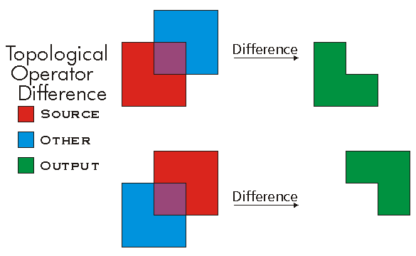
//The following code shows to wrap a line segment into a polyline in C#
//Assume a line (line1 as ILine) is already created
object obj = Type.Missing;
ISegmentCollection segCollection = new PolylineClass() as ISegmentCollection;
segCollection.AddSegment((ISegment)line1, ref obj, ref obj);
//Set the spatial reference on the new polyline
//The spatial reference is not transfered automatically from the segments
IGeometry geom = segCollection as IGeometry;
geom.SpatialReference = spatialRef;
//Can now be used with ITopologicalOperator methods
DifferenceEx(IGeometry, bool)
defined for (multi)points and polylines.
virtual IGeometry DifferenceEx(IGeometry other, bool bNonPlanar)Parameters
Returns
Dimension
The topological dimension of this geometry.
virtual esriGeometryDimension Dimension { get; }Returns
Remarks
Note: At 9.0, Multipatches are now considered as two dimensional geometry. esriGeometry3Dimension will be used for an upcoming new geometry type.
-1 esriGeometryNoDimension
1 esriGeometry0Dimension
2 esriGeometry1Dimension
4 esriGeometry2Dimension
5 esriGeometry25Dimension
6 esriGeometry3Dimension

Disjoint(IGeometry)
Indicates if the two geometries share no points in common. Negate this result to compute the Intersect relation.
virtual bool Disjoint(IGeometry other)Parameters
otherIGeometry
Returns
Remarks
Only geometries that support the IRelationalOperator interface can be used as input geometries.
Two geometries are disjoint if either one is empty.
Disjoint example. Only "true" relationships are showed in this picture.

Disjoint3D(IGeometry)
Indicates if the two geometries share no points in common. Negate this result to compute the Intersect relation.
virtual bool Disjoint3D(IGeometry pOther)Parameters
pOtherIGeometry
Returns
DropMs()
Sets all the M values to a non-valid number (NaN).
virtual void DropMs()DropPointIDs()
Unsets all PointID values without changing awareness. Only works if geometry is aware of PointIDs.
virtual void DropPointIDs()DropZs()
Sets all the Z values to a non-valid number (NaN).
virtual void DropZs()EnumCurve
A new curve enumerator for this segment collection.
virtual IEnumCurve EnumCurve { get; }Returns
EnumSegments
A new enumerator for this segment collection.
virtual IEnumSegment EnumSegments { get; }Returns
EnumVertices
A new enumerator for this point collection.
virtual IEnumVertex EnumVertices { get; }Returns
Envelope
Creates a copy of this geometry's envelope and returns it.
virtual IEnvelope Envelope { get; }Returns
Examples
<p class="MsoNormal" style=
"MARGIN: 0in 0in 0pt; LINE-HEIGHT: normal; mso-layout-grid-align: none">
<span style=
"FONT-SIZE: 10pt; FONT-FAMILY: 'Courier New'; mso-no-proof: yes"><span style="mso-spacerun: yes">
<img src="./bitmaps/envelope.gif" align=
"baseline"></span></span></p>
<p class="MsoNormal" style=
"MARGIN: 0in 0in 0pt; LINE-HEIGHT: normal; mso-layout-grid-align: none">
 </p>
<p class="MsoNormal" style=
"MARGIN: 0in 0in 0pt; LINE-HEIGHT: normal; mso-layout-grid-align: none">
<span style=
"FONT-SIZE: 10pt; FONT-FAMILY: 'Courier New'; mso-no-proof: yes"><span style="mso-spacerun: yes">
       </span> <span style=
"COLOR: blue">public</span> <span style="COLOR: blue">static</span>
<span style="COLOR: teal">IGeometry</span>
GetEnvelopeGeometry()</span></p>
<p class="MsoNormal" style=
"MARGIN: 0in 0in 0pt; LINE-HEIGHT: normal; mso-layout-grid-align: none">
<span style=
"FONT-SIZE: 10pt; FONT-FAMILY: 'Courier New'; mso-no-proof: yes"><span style="mso-spacerun: yes">
       </span> {</span></p>
<p class="MsoNormal" style=
"MARGIN: 0in 0in 0pt; LINE-HEIGHT: normal; mso-layout-grid-align: none">
<span style=
"FONT-SIZE: 10pt; FONT-FAMILY: 'Courier New'; mso-no-proof: yes"><span style="mso-spacerun: yes">
           </span>
<span style="COLOR: blue">const</span> <span style=
"COLOR: blue">double</span> DeltaX = 2.5;</span></p>
<p class="MsoNormal" style=
"MARGIN: 0in 0in 0pt; LINE-HEIGHT: normal; mso-layout-grid-align: none">
<span style=
"FONT-SIZE: 10pt; FONT-FAMILY: 'Courier New'; mso-no-proof: yes"><span style="mso-spacerun: yes">
           </span>
<span style="COLOR: blue">const</span> <span style=
"COLOR: blue">double</span> DeltaY = 2.5;</span></p>
<p class="MsoNormal" style=
"MARGIN: 0in 0in 0pt; LINE-HEIGHT: normal; mso-layout-grid-align: none">
<span style=
"FONT-SIZE: 10pt; FONT-FAMILY: 'Courier New'; mso-no-proof: yes"><span style="mso-spacerun: yes">
           </span>
<span style="COLOR: blue">const</span> <span style=
"COLOR: blue">double</span> DeltaZ = 2.5;</span></p>
<p class="MsoNormal" style=
"MARGIN: 0in 0in 0pt; LINE-HEIGHT: normal; mso-layout-grid-align: none">
<span style=
"FONT-SIZE: 10pt; FONT-FAMILY: 'Courier New'; mso-no-proof: yes"> </span></p>
<p class="MsoNormal" style=
"MARGIN: 0in 0in 0pt; LINE-HEIGHT: normal; mso-layout-grid-align: none">
<span style=
"FONT-SIZE: 10pt; FONT-FAMILY: 'Courier New'; mso-no-proof: yes"><span style="mso-spacerun: yes">
           </span>
<span style="COLOR: teal">IPoint</span> centerPoint =
GetPoint();</span></p>
<p class="MsoNormal" style=
"MARGIN: 0in 0in 0pt; LINE-HEIGHT: normal; mso-layout-grid-align: none">
<span style=
"FONT-SIZE: 10pt; FONT-FAMILY: 'Courier New'; mso-no-proof: yes"> </span></p>
<p class="MsoNormal" style=
"MARGIN: 0in 0in 0pt; LINE-HEIGHT: normal; mso-layout-grid-align: none">
<span style=
"FONT-SIZE: 10pt; FONT-FAMILY: 'Courier New'; mso-no-proof: yes"><span style="mso-spacerun: yes">
           </span>
<span style="COLOR: teal">IEnvelope</span> envelope = <span style=
"COLOR: blue">new</span> <span style=
"COLOR: teal">EnvelopeClass</span>();</span></p>
<p class="MsoNormal" style=
"MARGIN: 0in 0in 0pt; LINE-HEIGHT: normal; mso-layout-grid-align: none">
<span style=
"FONT-SIZE: 10pt; FONT-FAMILY: 'Courier New'; mso-no-proof: yes"><span style="mso-spacerun: yes">
           </span>
envelope.XMin = centerPoint.X - DeltaX;</span></p>
<p class="MsoNormal" style=
"MARGIN: 0in 0in 0pt; LINE-HEIGHT: normal; mso-layout-grid-align: none">
<span style=
"FONT-SIZE: 10pt; FONT-FAMILY: 'Courier New'; mso-no-proof: yes"><span style="mso-spacerun: yes">
           </span>
envelope.XMax = centerPoint.X + DeltaX;</span></p>
<p class="MsoNormal" style=
"MARGIN: 0in 0in 0pt; LINE-HEIGHT: normal; mso-layout-grid-align: none">
<span style=
"FONT-SIZE: 10pt; FONT-FAMILY: 'Courier New'; mso-no-proof: yes"><span style="mso-spacerun: yes">
           </span>
envelope.YMin = centerPoint.Y - DeltaY;</span></p>
<p class="MsoNormal" style=
"MARGIN: 0in 0in 0pt; LINE-HEIGHT: normal; mso-layout-grid-align: none">
<span style=
"FONT-SIZE: 10pt; FONT-FAMILY: 'Courier New'; mso-no-proof: yes"><span style="mso-spacerun: yes">
           </span>
envelope.YMax = centerPoint.Y + DeltaY;</span></p>
<p class="MsoNormal" style=
"MARGIN: 0in 0in 0pt; LINE-HEIGHT: normal; mso-layout-grid-align: none">
<span style=
"FONT-SIZE: 10pt; FONT-FAMILY: 'Courier New'; mso-no-proof: yes"><span style="mso-spacerun: yes">
           </span>
envelope.ZMin = centerPoint.Z - DeltaZ;</span></p>
<p class="MsoNormal" style=
"MARGIN: 0in 0in 0pt; LINE-HEIGHT: normal; mso-layout-grid-align: none">
<span style=
"FONT-SIZE: 10pt; FONT-FAMILY: 'Courier New'; mso-no-proof: yes"><span style="mso-spacerun: yes">
           </span>
envelope.ZMax = centerPoint.Z + DeltaZ;</span></p>
<p class="MsoNormal" style=
"MARGIN: 0in 0in 0pt; LINE-HEIGHT: normal; mso-layout-grid-align: none">
<span style=
"FONT-SIZE: 10pt; FONT-FAMILY: 'Courier New'; mso-no-proof: yes"> </span></p>
<p class="MsoNormal" style=
"MARGIN: 0in 0in 0pt; LINE-HEIGHT: normal; mso-layout-grid-align: none">
<span style=
"FONT-SIZE: 10pt; FONT-FAMILY: 'Courier New'; mso-no-proof: yes"><span style="mso-spacerun: yes">
           </span>
MakeZAware(envelope <span style="COLOR: blue">as</span>
<span style="COLOR: teal">IGeometry</span>);</span></p>
<p class="MsoNormal" style=
"MARGIN: 0in 0in 0pt; LINE-HEIGHT: normal; mso-layout-grid-align: none">
<span style=
"FONT-SIZE: 10pt; FONT-FAMILY: 'Courier New'; mso-no-proof: yes"> </span></p>
<p class="MsoNormal" style=
"MARGIN: 0in 0in 0pt; LINE-HEIGHT: normal; mso-layout-grid-align: none">
<span style=
"FONT-SIZE: 10pt; FONT-FAMILY: 'Courier New'; mso-no-proof: yes"><span style="mso-spacerun: yes">
           </span>
<span style="COLOR: blue">return</span> envelope <span style=
"COLOR: blue">as</span> <span style=
"COLOR: teal">IGeometry</span>;</span></p>
<p class="MsoNormal" style="MARGIN: 0in 0in 10pt"><span style=
"FONT-SIZE: 10pt; LINE-HEIGHT: 115%; FONT-FAMILY: 'Courier New'; mso-no-proof: yes">
<span style=
"mso-spacerun: yes">       </span>
}</span></p>
<p class="MsoNormal" style=
"MARGIN: 0in 0in 0pt; LINE-HEIGHT: normal; mso-layout-grid-align: none">
<span style=
"FONT-SIZE: 10pt; FONT-FAMILY: 'Courier New'; mso-no-proof: yes"><span style="mso-spacerun: yes">
       </span> <span style=
"COLOR: blue">private</span> <span style=
"COLOR: blue">static</span> <span style="COLOR: teal">IPoint</span>
GetPoint()</span></p>
<p class="MsoNormal" style=
"MARGIN: 0in 0in 0pt; LINE-HEIGHT: normal; mso-layout-grid-align: none">
<span style=
"FONT-SIZE: 10pt; FONT-FAMILY: 'Courier New'; mso-no-proof: yes"><span style="mso-spacerun: yes">
       </span> {</span></p>
<p class="MsoNormal" style=
"MARGIN: 0in 0in 0pt; LINE-HEIGHT: normal; mso-layout-grid-align: none">
<span style=
"FONT-SIZE: 10pt; FONT-FAMILY: 'Courier New'; mso-no-proof: yes"><span style="mso-spacerun: yes">
           </span>
<span style="COLOR: blue">const</span> <span style=
"COLOR: blue">double</span> Min = -10;</span></p>
<p class="MsoNormal" style=
"MARGIN: 0in 0in 0pt; LINE-HEIGHT: normal; mso-layout-grid-align: none">
<span style=
"FONT-SIZE: 10pt; FONT-FAMILY: 'Courier New'; mso-no-proof: yes"><span style="mso-spacerun: yes">
           </span>
<span style="COLOR: blue">const</span> <span style=
"COLOR: blue">double</span> Max = 10;</span></p>
<p class="MsoNormal" style=
"MARGIN: 0in 0in 0pt; LINE-HEIGHT: normal; mso-layout-grid-align: none">
<span style=
"FONT-SIZE: 10pt; FONT-FAMILY: 'Courier New'; mso-no-proof: yes"> </span></p>
<p class="MsoNormal" style=
"MARGIN: 0in 0in 0pt; LINE-HEIGHT: normal; mso-layout-grid-align: none">
<span style=
"FONT-SIZE: 10pt; FONT-FAMILY: 'Courier New'; mso-no-proof: yes"><span style="mso-spacerun: yes">
           </span>
<span style="COLOR: teal">Random</span> random = <span style=
"COLOR: blue">new</span> <span style=
"COLOR: teal">Random</span>();</span></p>
<p class="MsoNormal" style=
"MARGIN: 0in 0in 0pt; LINE-HEIGHT: normal; mso-layout-grid-align: none">
<span style=
"FONT-SIZE: 10pt; FONT-FAMILY: 'Courier New'; mso-no-proof: yes"> </span></p>
<p class="MsoNormal" style=
"MARGIN: 0in 0in 0pt; LINE-HEIGHT: normal; mso-layout-grid-align: none">
<span style=
"FONT-SIZE: 10pt; FONT-FAMILY: 'Courier New'; mso-no-proof: yes"><span style="mso-spacerun: yes">
           </span>
<span style="COLOR: blue">double</span> x = Min + (Max - Min) *
random.NextDouble();</span></p>
<p class="MsoNormal" style=
"MARGIN: 0in 0in 0pt; LINE-HEIGHT: normal; mso-layout-grid-align: none">
<span style=
"FONT-SIZE: 10pt; FONT-FAMILY: 'Courier New'; mso-no-proof: yes"><span style="mso-spacerun: yes">
           </span>
<span style="COLOR: blue">double</span> y = Min + (Max - Min) *
random.NextDouble();</span></p>
<p class="MsoNormal" style=
"MARGIN: 0in 0in 0pt; LINE-HEIGHT: normal; mso-layout-grid-align: none">
<span style=
"FONT-SIZE: 10pt; FONT-FAMILY: 'Courier New'; mso-no-proof: yes"><span style="mso-spacerun: yes">
           </span>
<span style="COLOR: blue">double</span> z = Min + (Max - Min) *
random.NextDouble();</span></p>
<p class="MsoNormal" style=
"MARGIN: 0in 0in 0pt; LINE-HEIGHT: normal; mso-layout-grid-align: none">
<span style=
"FONT-SIZE: 10pt; FONT-FAMILY: 'Courier New'; mso-no-proof: yes"> </span></p>
<p class="MsoNormal" style=
"MARGIN: 0in 0in 0pt; LINE-HEIGHT: normal; mso-layout-grid-align: none">
<span style=
"FONT-SIZE: 10pt; FONT-FAMILY: 'Courier New'; mso-no-proof: yes"><span style="mso-spacerun: yes">
           </span>
<span style="COLOR: blue">return</span> ConstructPoint3D(x, y,
z);</span></p>
<p class="MsoNormal" style=
"MARGIN: 0in 0in 0pt; LINE-HEIGHT: normal; mso-layout-grid-align: none">
<span style=
"FONT-SIZE: 10pt; FONT-FAMILY: 'Courier New'; mso-no-proof: yes"><span style="mso-spacerun: yes">
       </span> }</span></p>
<p class="MsoNormal" style=
"MARGIN: 0in 0in 0pt; LINE-HEIGHT: normal; mso-layout-grid-align: none">
<span style=
"FONT-SIZE: 10pt; FONT-FAMILY: 'Courier New'; mso-no-proof: yes"> </span></p>
<p class="MsoNormal" style=
"MARGIN: 0in 0in 0pt; LINE-HEIGHT: normal; mso-layout-grid-align: none">
<span style=
"FONT-SIZE: 10pt; COLOR: black; FONT-FAMILY: 'Courier New'; mso-no-proof: yes; mso-fareast-font-family: 'Times New Roman'">
<span style=
"mso-spacerun: yes">       </span></span>
<span style=
"FONT-SIZE: 10pt; COLOR: blue; FONT-FAMILY: 'Courier New'; mso-no-proof: yes; mso-fareast-font-family: 'Times New Roman'">
private</span> <span style=
"FONT-SIZE: 10pt; COLOR: blue; FONT-FAMILY: 'Courier New'; mso-no-proof: yes; mso-fareast-font-family: 'Times New Roman'">
static</span> <span style=
"FONT-SIZE: 10pt; COLOR: teal; FONT-FAMILY: 'Courier New'; mso-no-proof: yes; mso-fareast-font-family: 'Times New Roman'">
IPoint</span> <span style=
"FONT-SIZE: 10pt; COLOR: black; FONT-FAMILY: 'Courier New'; mso-no-proof: yes; mso-fareast-font-family: 'Times New Roman'">
ConstructPoint3D(</span><span style=
"FONT-SIZE: 10pt; COLOR: blue; FONT-FAMILY: 'Courier New'; mso-no-proof: yes; mso-fareast-font-family: 'Times New Roman'">double</span>
<span style=
"FONT-SIZE: 10pt; COLOR: black; FONT-FAMILY: 'Courier New'; mso-no-proof: yes; mso-fareast-font-family: 'Times New Roman'">
x,</span> <span style=
"FONT-SIZE: 10pt; COLOR: blue; FONT-FAMILY: 'Courier New'; mso-no-proof: yes; mso-fareast-font-family: 'Times New Roman'">
double</span> <span style=
"FONT-SIZE: 10pt; COLOR: black; FONT-FAMILY: 'Courier New'; mso-no-proof: yes; mso-fareast-font-family: 'Times New Roman'">
y,</span> <span style=
"FONT-SIZE: 10pt; COLOR: blue; FONT-FAMILY: 'Courier New'; mso-no-proof: yes; mso-fareast-font-family: 'Times New Roman'">
double</span> <span style=
"FONT-SIZE: 10pt; COLOR: black; FONT-FAMILY: 'Courier New'; mso-no-proof: yes; mso-fareast-font-family: 'Times New Roman'">
z)</span></p>
<p class="MsoNormal" style=
"MARGIN: 0in 0in 0pt; LINE-HEIGHT: normal; mso-layout-grid-align: none">
<span style=
"FONT-SIZE: 10pt; COLOR: black; FONT-FAMILY: 'Courier New'; mso-no-proof: yes; mso-fareast-font-family: 'Times New Roman'">
<span style=
"mso-spacerun: yes">       </span>
{</span></p>
<p class="MsoNormal" style=
"MARGIN: 0in 0in 0pt; LINE-HEIGHT: normal; mso-layout-grid-align: none">
<span style=
"FONT-SIZE: 10pt; COLOR: black; FONT-FAMILY: 'Courier New'; mso-no-proof: yes; mso-fareast-font-family: 'Times New Roman'">
<span style=
"mso-spacerun: yes">           </span></span>
<span style=
"FONT-SIZE: 10pt; COLOR: teal; FONT-FAMILY: 'Courier New'; mso-no-proof: yes; mso-fareast-font-family: 'Times New Roman'">
IPoint</span> <span style=
"FONT-SIZE: 10pt; COLOR: black; FONT-FAMILY: 'Courier New'; mso-no-proof: yes; mso-fareast-font-family: 'Times New Roman'">
point = ConstructPoint2D(x, y);</span></p>
<p class="MsoNormal" style=
"MARGIN: 0in 0in 0pt; LINE-HEIGHT: normal; mso-layout-grid-align: none">
<span style=
"FONT-SIZE: 10pt; COLOR: black; FONT-FAMILY: 'Courier New'; mso-no-proof: yes; mso-fareast-font-family: 'Times New Roman'">
<span style=
"mso-spacerun: yes">           </span>
point.Z = z;<br>
<br>
<span style=
"mso-spacerun: yes">           </span></span>
<span style=
"FONT-SIZE: 10pt; COLOR: blue; FONT-FAMILY: 'Courier New'; mso-no-proof: yes; mso-fareast-font-family: 'Times New Roman'">
return</span> <span style=
"FONT-SIZE: 10pt; COLOR: black; FONT-FAMILY: 'Courier New'; mso-no-proof: yes; mso-fareast-font-family: 'Times New Roman'">
point;</span></p>
<p class="MsoNormal" style=
"MARGIN: 0in 0in 0pt; LINE-HEIGHT: normal; mso-layout-grid-align: none">
<span style=
"FONT-SIZE: 10pt; COLOR: black; FONT-FAMILY: 'Courier New'; mso-no-proof: yes; mso-fareast-font-family: 'Times New Roman'">
<span style=
"mso-spacerun: yes">       </span>
}<br>
<br style="mso-special-character: line-break">
<br style="mso-special-character: line-break"></span></p>
<p class="MsoNormal" style=
"MARGIN: 0in 0in 0pt; LINE-HEIGHT: normal; mso-layout-grid-align: none">
<span style=
"FONT-SIZE: 10pt; COLOR: black; FONT-FAMILY: 'Courier New'; mso-no-proof: yes; mso-fareast-font-family: 'Times New Roman'">
<span style=
"mso-spacerun: yes">       </span></span>
<span style=
"FONT-SIZE: 10pt; COLOR: blue; FONT-FAMILY: 'Courier New'; mso-no-proof: yes; mso-fareast-font-family: 'Times New Roman'">
private</span> <span style=
"FONT-SIZE: 10pt; COLOR: blue; FONT-FAMILY: 'Courier New'; mso-no-proof: yes; mso-fareast-font-family: 'Times New Roman'">
static</span> <span style=
"FONT-SIZE: 10pt; COLOR: teal; FONT-FAMILY: 'Courier New'; mso-no-proof: yes; mso-fareast-font-family: 'Times New Roman'">
IPoint</span> <span style=
"FONT-SIZE: 10pt; COLOR: black; FONT-FAMILY: 'Courier New'; mso-no-proof: yes; mso-fareast-font-family: 'Times New Roman'">
ConstructPoint2D(</span><span style=
"FONT-SIZE: 10pt; COLOR: blue; FONT-FAMILY: 'Courier New'; mso-no-proof: yes; mso-fareast-font-family: 'Times New Roman'">double</span>
<span style=
"FONT-SIZE: 10pt; COLOR: black; FONT-FAMILY: 'Courier New'; mso-no-proof: yes; mso-fareast-font-family: 'Times New Roman'">
x,</span> <span style=
"FONT-SIZE: 10pt; COLOR: blue; FONT-FAMILY: 'Courier New'; mso-no-proof: yes; mso-fareast-font-family: 'Times New Roman'">
double</span> <span style=
"FONT-SIZE: 10pt; COLOR: black; FONT-FAMILY: 'Courier New'; mso-no-proof: yes; mso-fareast-font-family: 'Times New Roman'">
y)</span></p>
<p class="MsoNormal" style=
"MARGIN: 0in 0in 0pt; LINE-HEIGHT: normal; mso-layout-grid-align: none">
<span style=
"FONT-SIZE: 10pt; COLOR: black; FONT-FAMILY: 'Courier New'; mso-no-proof: yes; mso-fareast-font-family: 'Times New Roman'">
<span style=
"mso-spacerun: yes">       </span>
{</span></p>
<p class="MsoNormal" style=
"MARGIN: 0in 0in 0pt; LINE-HEIGHT: normal; mso-layout-grid-align: none">
<span style=
"FONT-SIZE: 10pt; COLOR: black; FONT-FAMILY: 'Courier New'; mso-no-proof: yes; mso-fareast-font-family: 'Times New Roman'">
<span style=
"mso-spacerun: yes">           </span></span>
<span style=
"FONT-SIZE: 10pt; COLOR: teal; FONT-FAMILY: 'Courier New'; mso-no-proof: yes; mso-fareast-font-family: 'Times New Roman'">
IPoint</span> <span style=
"FONT-SIZE: 10pt; COLOR: black; FONT-FAMILY: 'Courier New'; mso-no-proof: yes; mso-fareast-font-family: 'Times New Roman'">
point =</span> <span style=
"FONT-SIZE: 10pt; COLOR: blue; FONT-FAMILY: 'Courier New'; mso-no-proof: yes; mso-fareast-font-family: 'Times New Roman'">
new</span> <span style=
"FONT-SIZE: 10pt; COLOR: teal; FONT-FAMILY: 'Courier New'; mso-no-proof: yes; mso-fareast-font-family: 'Times New Roman'">
PointClass</span><span style=
"FONT-SIZE: 10pt; COLOR: black; FONT-FAMILY: 'Courier New'; mso-no-proof: yes; mso-fareast-font-family: 'Times New Roman'">();</span></p>
<p class="MsoNormal" style=
"MARGIN: 0in 0in 0pt; LINE-HEIGHT: normal; mso-layout-grid-align: none">
<span style=
"FONT-SIZE: 10pt; COLOR: black; FONT-FAMILY: 'Courier New'; mso-no-proof: yes; mso-fareast-font-family: 'Times New Roman'">
<span style=
"mso-spacerun: yes">           </span>
point.PutCoords(x, y);<br>
<span style="mso-spacerun: yes"> </span></span></p>
<p class="MsoNormal" style=
"MARGIN: 0in 0in 0pt; LINE-HEIGHT: normal; mso-layout-grid-align: none">
<span style=
"FONT-SIZE: 10pt; COLOR: black; FONT-FAMILY: 'Courier New'; mso-no-proof: yes; mso-fareast-font-family: 'Times New Roman'">
<span style=
"mso-spacerun: yes">           </span></span>
<span style=
"FONT-SIZE: 10pt; COLOR: blue; FONT-FAMILY: 'Courier New'; mso-no-proof: yes; mso-fareast-font-family: 'Times New Roman'">
return</span> <span style=
"FONT-SIZE: 10pt; COLOR: black; FONT-FAMILY: 'Courier New'; mso-no-proof: yes; mso-fareast-font-family: 'Times New Roman'">
point;</span></p>
<p class="MsoNormal" style=
"MARGIN: 0in 0in 10pt; LINE-HEIGHT: normal"><span style=
"FONT-SIZE: 10pt; COLOR: black; FONT-FAMILY: 'Courier New'; mso-no-proof: yes; mso-fareast-font-family: 'Times New Roman'">
<span style=
"mso-spacerun: yes">       </span>
}</span></p>
<p class="MsoNormal" style=
"MARGIN: 0in 0in 0pt; LINE-HEIGHT: normal; mso-layout-grid-align: none">
<span style=
"FONT-SIZE: 10pt; FONT-FAMILY: 'Courier New'; mso-no-proof: yes"><span style="mso-spacerun: yes">
       </span> <span style=
"COLOR: blue">private</span> <span style=
"COLOR: blue">static</span> <span style="COLOR: blue">void</span>
MakeZAware(<span style="COLOR: teal">IGeometry</span>
geometry)</span></p>
<p class="MsoNormal" style=
"MARGIN: 0in 0in 0pt; LINE-HEIGHT: normal; mso-layout-grid-align: none">
<span style=
"FONT-SIZE: 10pt; FONT-FAMILY: 'Courier New'; mso-no-proof: yes"><span style="mso-spacerun: yes">
       </span> {</span></p>
<p class="MsoNormal" style=
"MARGIN: 0in 0in 0pt; LINE-HEIGHT: normal; mso-layout-grid-align: none">
<span style=
"FONT-SIZE: 10pt; FONT-FAMILY: 'Courier New'; mso-no-proof: yes"><span style="mso-spacerun: yes">
           </span>
<span style="COLOR: teal">IZAware</span> zAware = geometry
<span style="COLOR: blue">as</span> <span style=
"COLOR: teal">IZAware</span>;</span></p>
<p class="MsoNormal" style=
"MARGIN: 0in 0in 0pt; LINE-HEIGHT: normal; mso-layout-grid-align: none">
<span style=
"FONT-SIZE: 10pt; FONT-FAMILY: 'Courier New'; mso-no-proof: yes"><span style="mso-spacerun: yes">
           </span>
zAware.ZAware = <span style="COLOR: blue">true</span>;</span></p>
<p class="MsoNormal" style=
"MARGIN: 0in 0in 0pt; LINE-HEIGHT: normal; mso-layout-grid-align: none">
<span style=
"FONT-SIZE: 10pt; FONT-FAMILY: 'Courier New'; mso-no-proof: yes"><span style="mso-spacerun: yes">
       </span> }</span></p>
Remarks

Equals(IGeometry)
Indicates if the two geometries are of the same type and define the same set of points in the plane.
virtual bool Equals(IGeometry other)Parameters
otherIGeometry
Returns
Remarks
Only geometries that support the IRelationalOperator interface can be used as input geometries. GeometryBags are not supported. IRelationalOperator::Equals delegates to ITopologicalOperatorSymmetricDifference and returns true when that method returns an empty geometry; M's and Z's are ignored. Please use IClone::IsEqual if M's and Z's need to be compared.
IClone::IsEqual simply iterates over each segment in each geometry, in index order, and compares their types and coordinates (but using the spatial reference's cluster tolerances to determine equality of coordinates).
Only "true" relationships are showed in this picture.

The RCW for the IRelationalOperator inherits from System.Object, as do all reference types in .NET. The System.Object type has a method called Equals, which results in the IRelationalOperator RCW having two overloaded versions of the Equals method. Ensure that you are not using the Equals method inherited from the System.Object class by mistake, by making sure you pass in an IGeometry reference to the Equals method. For example, the following extract of code from a C# console application demonstrates calling Equals correctly.
ESRI.ArcGIS.Geometry.IPoint pt1 = new ESRI.ArcGIS.Geometry.PointClass();
pt1.PutCoords(5, 5);
ESRI.ArcGIS.Geometry.IPoint pt2 = new ESRI.ArcGIS.Geometry.PointClass();
pt2.PutCoords(5, 5);
ESRI.ArcGIS.Geometry.IRelationalOperator rel1 = pt1 as ESRI.ArcGIS.Geometry.IRelationalOperator;
ESRI.ArcGIS.Geometry.IGeometry geom2 = pt2 as ESRI.ArcGIS.Geometry.IGeometry;
bool relEqual = rel1.Equals(pt2); //calling IRelationalOperator::Equals
Console.WriteLine("Equal: " + relEqual.ToString());
bool netEqual =  rel1.Equals(pt2 as object);  //calling Object::Equals
Console.WriteLine("Equal: " + netEqual.ToString());
ExteriorRingBag
Creates and returns a geometry bag that contains references to all exterior rings.
virtual IGeometryBag ExteriorRingBag { get; }Returns
ExteriorRingCount
The number of exterior rings.
virtual int ExteriorRingCount { get; }Returns
Remarks

ExtrapolateMs(esriExtrapolationEnum, int, int, int, int)
Extrapolates the Ms at one or both ends of the geometry based on the M interval between the fromIndex and the toIndex.
virtual void ExtrapolateMs(esriExtrapolationEnum extrapolationStyle, int fromPart, int FromPoint, int toPart, int ToPoint)Parameters
extrapolationStyleesriExtrapolationEnumfromPartintFromPointinttoPartintToPointint
FindExteriorRing(IRing)
Returns the exterior ring containing the specified interior ring.
virtual IRing FindExteriorRing(IRing interiorRing)Parameters
interiorRingIRing
Returns
Remarks
FromPoint
The 'from' point of the curve.
virtual IPoint FromPoint { get; set; }Returns
Remarks

Generalize(double)
Generalizes this polycurve using the Douglas-Peucker algorithm.
virtual void Generalize(double maxAllowableOffset)Parameters
maxAllowableOffsetdouble
Remarks
For polycurve with non-linear segments, the output curve may contain more vertices than the input curve, but all output segments will be linear.

Generalize3D(double)
Generalizes this polycurve using the Douglas-Peucker algorithm.
virtual void Generalize3D(double maxAllowableOffset)Parameters
maxAllowableOffsetdouble
GeoNormalize()
Shifts longitudes, if need be, into a continuous range of 360 degrees.
virtual void GeoNormalize()Remarks
GeoNormalizeEx(ISpatialReference, double)
Shifts longitudes, if need be, into a continuous range of 360 degrees.
virtual void GeoNormalizeEx(ISpatialReference SR, double denseDistance)Parameters
SRISpatialReferencedenseDistancedouble
Remarks
Not implemented for Multipatches.
GeoNormalizeFromLongitude(double)
Normalizes longitudes into a continuous range containing the longitude. This method is obsolete.
virtual void GeoNormalizeFromLongitude(double Longitude)Parameters
Longitudedouble
Remarks
GeodesicDensify(double)
virtual void GeodesicDensify(double maxSegmentLength)Parameters
maxSegmentLengthdouble
GeometriesChanged()
Tells this geometry collection that some of its geometries have been altered. Use this method on polylines, polygons and multipatches after directly editing one of its parts.
virtual void GeometriesChanged()Geometry[int]
A reference to the ith geometry.
virtual IGeometry Geometry[int Index] { get; }Parameters
Indexint
Returns
Remarks
Note: The GeometryType returned by the Geometry method depends on which object type points the IGeometryCollection pointer.
| IGeometryCollection Object GeometryType | Returned Object GeometryType |
| Polygon |
Rings |
| Polyline |
Paths |
| Multipoint |
Points |
| Multipatch |
TriangleFans or TriangleStrips or Rings |
| TriangleFan |
Points |
| TriangleStrip |
Points |
| Geometry Bag |
Any type of IGeometry |
GeometryCount
The number of geometries in this collection.
virtual int GeometryCount { get; }Returns
GeometryType
The type of this geometry.
virtual esriGeometryType GeometryType { get; }Returns
Remarks
esriGeometryNull          = 0
esriGeometryPoint         = 1
esriGeometryMultipoint    = 2
esriGeometryPolyline      = 3
esriGeometryPolygon       = 4
esriGeometryEnvelope      = 5
esriGeometryPath          = 6
esriGeometryAny           = 7
esriGeometryMultiPatch    = 9
esriGeometryRing          = 11
esriGeometryLine          = 13
esriGeometryCircularArc   = 14
esriGeometryBezier3Curve  = 15
esriGeometryEllipticArc   = 16
esriGeometryBag           = 17
esriGeometryTriangleStrip = 18
esriGeometryTriangleFan   = 19
esriGeometryRay           = 20
esriGeometrySphere        = 21

GetClassID(out Guid)
virtual void GetClassID(out Guid pClassID)Parameters
pClassIDGuid
GetConnectedComponents(int, out IPolygon)
Populates an array with polygons that represent connected components of the original. The rings of the output polygons are references to rings in the original.
virtual void GetConnectedComponents(int numComponentsRequested, out IPolygon components)Parameters
Remarks
The method returns an error in the following cases:
1. Number of components requested is smaller than 0
2. Number of components requested larger than the number of exterior rings
3. If the array is not dimensionned
4. If the polygon is not simple

Does not work in .NET. Use IPolygon4.get_ConnectedComponentBag instead.
GetConnectedComponents2(out IPolygon[])
Populates an array with polygons that represent connected components of the original. The rings of the output polygons are references to rings in the original.
virtual void GetConnectedComponents2(out IPolygon[] components)Parameters
componentsIPolygon[]
GetDistancesAtM(bool, double)
Returns an array of distances along the polyline at which is located the specified M. If the geometry's M's are monotonic along the geometry then the array will only have one element.
virtual object GetDistancesAtM(bool asRatio, double M)Parameters
Returns
GetMsAtDistance(double, bool)
Returns M values at the distance along the geometry. An array of one or two Ms is returned. Two Ms can be returned if the given distance is exactly at the beginning or ending of a part.
virtual object GetMsAtDistance(double distance, bool asRatio)Parameters
Returns
GetOutermostComponents(int, out int, out IPolygon, out bool)
Populates an array with polygons that represent outermost components of the original and all components within (islands within lakes). The rings of the output polygons are references to rings in the original.
virtual void GetOutermostComponents(int numComponentsRequested, out int numComponentsReturned, out IPolygon components, out bool moreComponentsExist)Parameters
Remarks
The method returns an error in the following cases:
1. Number of components requested is smaller than 0
2. If the array is not dimensionned
3. If the polygon is not simple

Does not work in .NET. Use IPolygon4.get_OutermostComponentBag instead.
GetOutermostComponents2(out IPolygon[], out bool)
Populates an array with polygons that represent outermost components of the original and all components within (islands within lakes). The rings of the output polygons are references to rings in the original.
virtual void GetOutermostComponents2(out IPolygon[] components, out bool moreComponentsExist)Parameters
GetPoints(int, int, out IPoint)
virtual void GetPoints(int Index, int Count, out IPoint Points)Parameters
GetPointsAtM(double, double)
Returns a multipoint geometry corresponding to the locations along the geometry where the specified M occurs.
virtual IGeometryCollection GetPointsAtM(double M, double lateralOffset)Parameters
Returns
GetSizeMax(out _ULARGE_INTEGER)
virtual void GetSizeMax(out _ULARGE_INTEGER pcbSize)Parameters
pcbSize_ULARGE_INTEGER
GetSubcurve(double, double, bool, out ICurve)
Extracts a portion of this curve into a new curve.
virtual void GetSubcurve(double fromDistance, double toDistance, bool asRatio, out ICurve outSubcurve)Parameters
Remarks

GetSubcurve3D(double, double, bool, out ICurve3D)
Extracts a portion of this curve into a new curve.
virtual void GetSubcurve3D(double fromDistance, double toDistance, bool bAsRatio, out ICurve3D ppOutSubCurve)Parameters
GetSubcurveBetweenMs(double, double)
Returns a polyline geometry corresponding to the subcurve(s) between the fromM and the toM.
virtual IGeometryCollection GetSubcurveBetweenMs(double fromM, double toM)Parameters
Returns
HasNonLinearSegments(ref bool)
Indicates if this segment collection contains segments other than lines.
virtual void HasNonLinearSegments(ref bool nonLinearSegments)Parameters
nonLinearSegmentsbool
HitTest(IPoint, double, esriGeometryHitPartType, IPoint, ref double, ref int, ref int, ref bool)
Locates a part of a geometry closest to a query point. Any located part must be within searchRadius units from the query point.
virtual bool HitTest(IPoint QueryPoint, double searchRadius, esriGeometryHitPartType geometryPart, IPoint hitPoint, ref double hitDistance, ref int hitPartIndex, ref int hitSegmentIndex, ref bool bRightSide)Parameters
QueryPointIPointsearchRadiusdoublegeometryPartesriGeometryHitPartTypehitPointIPointhitDistancedoublehitPartIndexinthitSegmentIndexintbRightSidebool
Returns
Remarks
The segment index returned has different meanings depending on the esriGeometryHitPartType used (Please see the example for more details).
EsriGeometryPartVertex: returns a vertex index
EsriGeometryPartBoundary, esriGeometryPartMidpoint and esriGeometryPartEndpoint: return a segment index
EsriGeometryPartCentroid: Always returns 0 for the part index and the segment index.
brightside: Indicates if the input point is on the right side of the input geometry
Note: The distance units use in this method are the units of the input geometry. No conversion is performed. esriGeometryHitPartType parameter cannot be a combination of several esriGeometryHitPartTypes.
HitTest3D(IPoint, double, esriGeometryHitPartType, IPoint, ref double, ref int, ref int)
Locates a part of a geometry closest to a query point. Any located part must be within searchRadius units from the query point.
virtual bool HitTest3D(IPoint QueryPoint, double searchRadius, esriGeometryHitPartType geometryPart, IPoint hitPoint, ref double hitDistance, ref int hitPartIndex, ref int hitSegmentIndex)Parameters
QueryPointIPointsearchRadiusdoublegeometryPartesriGeometryHitPartTypehitPointIPointhitDistancedoublehitPartIndexinthitSegmentIndexint
Returns
HitTestCone(IRay, double, esriGeometryHitPartType, IPoint, ref double, ref int, ref int)
Locates a part of a geometry closest to a query ray.
virtual bool HitTestCone(IRay pQueryRay, double minAngle, esriGeometryHitPartType geometryPart, IPoint pHitPoint, ref double pHitDistance, ref int pHitPartIndex, ref int pHitSegmentIndex)Parameters
pQueryRayIRayminAngledoublegeometryPartesriGeometryHitPartTypepHitPointIPointpHitDistancedoublepHitPartIndexintpHitSegmentIndexint
Returns
IConstructCurve2_ConstructExtended(ICurve, ICurve, int, ref bool)
virtual void IConstructCurve2_ConstructExtended(ICurve fromCurve, ICurve toCurve, int extensionFlags, ref bool extensionsPerformed)Parameters
IConstructCurve2_ConstructKoch(IPolycurve, double, int)
virtual void IConstructCurve2_ConstructKoch(IPolycurve p, double r, int recursionLevel)Parameters
pIPolycurverdoublerecursionLevelint
IConstructCurve2_ConstructOffset(IPolycurve, double, ref object, ref object)
virtual void IConstructCurve2_ConstructOffset(IPolycurve inCurve, double Offset, ref object offsetHow, ref object bevelRatio)Parameters
inCurveIPolycurveOffsetdoubleoffsetHowobjectbevelRatioobject
ICurve_Dimension
virtual esriGeometryDimension ICurve_Dimension { get; }Returns
ICurve_Envelope
virtual IEnvelope ICurve_Envelope { get; }Returns
ICurve_GeoNormalize()
virtual void ICurve_GeoNormalize()ICurve_GeoNormalizeFromLongitude(double)
virtual void ICurve_GeoNormalizeFromLongitude(double Longitude)Parameters
Longitudedouble
ICurve_GeometryType
virtual esriGeometryType ICurve_GeometryType { get; }Returns
ICurve_IsEmpty
virtual bool ICurve_IsEmpty { get; }Returns
ICurve_Project(ISpatialReference)
virtual void ICurve_Project(ISpatialReference newReferenceSystem)Parameters
newReferenceSystemISpatialReference
ICurve_QueryEnvelope(IEnvelope)
virtual void ICurve_QueryEnvelope(IEnvelope outEnvelope)Parameters
outEnvelopeIEnvelope
ICurve_SetEmpty()
virtual void ICurve_SetEmpty()ICurve_SnapToSpatialReference()
virtual void ICurve_SnapToSpatialReference()ICurve_SpatialReference
virtual ISpatialReference ICurve_SpatialReference { get; set; }Returns
IGeometry2_Dimension
virtual esriGeometryDimension IGeometry2_Dimension { get; }Returns
IGeometry2_Envelope
virtual IEnvelope IGeometry2_Envelope { get; }Returns
IGeometry2_GeoNormalize()
virtual void IGeometry2_GeoNormalize()IGeometry2_GeoNormalizeFromLongitude(double)
virtual void IGeometry2_GeoNormalizeFromLongitude(double Longitude)Parameters
Longitudedouble
IGeometry2_GeometryType
virtual esriGeometryType IGeometry2_GeometryType { get; }Returns
IGeometry2_IsEmpty
virtual bool IGeometry2_IsEmpty { get; }Returns
IGeometry2_Project(ISpatialReference)
virtual void IGeometry2_Project(ISpatialReference newReferenceSystem)Parameters
newReferenceSystemISpatialReference
IGeometry2_QueryEnvelope(IEnvelope)
virtual void IGeometry2_QueryEnvelope(IEnvelope outEnvelope)Parameters
outEnvelopeIEnvelope
IGeometry2_SetEmpty()
virtual void IGeometry2_SetEmpty()IGeometry2_SnapToSpatialReference()
virtual void IGeometry2_SnapToSpatialReference()IGeometry2_SpatialReference
virtual ISpatialReference IGeometry2_SpatialReference { get; set; }Returns
IGeometry3_Dimension
virtual esriGeometryDimension IGeometry3_Dimension { get; }Returns
IGeometry3_Envelope
virtual IEnvelope IGeometry3_Envelope { get; }Returns
IGeometry3_GeoNormalize()
virtual void IGeometry3_GeoNormalize()IGeometry3_GeoNormalizeFromLongitude(double)
virtual void IGeometry3_GeoNormalizeFromLongitude(double Longitude)Parameters
Longitudedouble
IGeometry3_GeometryType
virtual esriGeometryType IGeometry3_GeometryType { get; }Returns
IGeometry3_IsEmpty
virtual bool IGeometry3_IsEmpty { get; }Returns
IGeometry3_Project(ISpatialReference)
virtual void IGeometry3_Project(ISpatialReference newReferenceSystem)Parameters
newReferenceSystemISpatialReference
IGeometry3_ProjectEx(ISpatialReference, esriTransformDirection, IGeoTransformation, bool, double, double)
virtual void IGeometry3_ProjectEx(ISpatialReference newReferenceSystem, esriTransformDirection Direction, IGeoTransformation GeoTransformation, bool bAngularDensify, double maxSegmentLength, double maxDeviation)Parameters
newReferenceSystemISpatialReferenceDirectionesriTransformDirectionGeoTransformationIGeoTransformationbAngularDensifyboolmaxSegmentLengthdoublemaxDeviationdouble
IGeometry3_QueryEnvelope(IEnvelope)
virtual void IGeometry3_QueryEnvelope(IEnvelope outEnvelope)Parameters
outEnvelopeIEnvelope
IGeometry3_SetEmpty()
virtual void IGeometry3_SetEmpty()IGeometry3_SnapToSpatialReference()
virtual void IGeometry3_SnapToSpatialReference()IGeometry3_SpatialReference
virtual ISpatialReference IGeometry3_SpatialReference { get; set; }Returns
IGeometry4_Dimension
virtual esriGeometryDimension IGeometry4_Dimension { get; }Returns
IGeometry4_Envelope
virtual IEnvelope IGeometry4_Envelope { get; }Returns
IGeometry4_GeoNormalize()
virtual void IGeometry4_GeoNormalize()IGeometry4_GeoNormalizeFromLongitude(double)
virtual void IGeometry4_GeoNormalizeFromLongitude(double Longitude)Parameters
Longitudedouble
IGeometry4_GeometryType
virtual esriGeometryType IGeometry4_GeometryType { get; }Returns
IGeometry4_IsEmpty
virtual bool IGeometry4_IsEmpty { get; }Returns
IGeometry4_Project(ISpatialReference)
virtual void IGeometry4_Project(ISpatialReference newReferenceSystem)Parameters
newReferenceSystemISpatialReference
IGeometry4_ProjectEx(ISpatialReference, esriTransformDirection, IGeoTransformation, bool, double, double)
virtual void IGeometry4_ProjectEx(ISpatialReference newReferenceSystem, esriTransformDirection Direction, IGeoTransformation GeoTransformation, bool bAngularDensify, double maxSegmentLength, double maxDeviation)Parameters
newReferenceSystemISpatialReferenceDirectionesriTransformDirectionGeoTransformationIGeoTransformationbAngularDensifyboolmaxSegmentLengthdoublemaxDeviationdouble
IGeometry4_QueryEnvelope(IEnvelope)
virtual void IGeometry4_QueryEnvelope(IEnvelope outEnvelope)Parameters
outEnvelopeIEnvelope
IGeometry4_QueryWKSEnvelope(out WKSEnvelope)
virtual void IGeometry4_QueryWKSEnvelope(out WKSEnvelope e)Parameters
IGeometry4_SetEmpty()
virtual void IGeometry4_SetEmpty()IGeometry4_SnapToSpatialReference()
virtual void IGeometry4_SnapToSpatialReference()IGeometry4_SpatialReference
virtual ISpatialReference IGeometry4_SpatialReference { get; set; }Returns
IGeometry5_Changed
virtual bool IGeometry5_Changed { get; set; }Returns
IGeometry5_Dimension
virtual esriGeometryDimension IGeometry5_Dimension { get; }Returns
IGeometry5_Envelope
virtual IEnvelope IGeometry5_Envelope { get; }Returns
IGeometry5_GeoNormalize()
virtual void IGeometry5_GeoNormalize()IGeometry5_GeoNormalizeFromLongitude(double)
virtual void IGeometry5_GeoNormalizeFromLongitude(double Longitude)Parameters
Longitudedouble
IGeometry5_GeometryType
virtual esriGeometryType IGeometry5_GeometryType { get; }Returns
IGeometry5_IsEmpty
virtual bool IGeometry5_IsEmpty { get; }Returns
IGeometry5_Project(ISpatialReference)
virtual void IGeometry5_Project(ISpatialReference newReferenceSystem)Parameters
newReferenceSystemISpatialReference
IGeometry5_ProjectEx(ISpatialReference, esriTransformDirection, IGeoTransformation, bool, double, double)
virtual void IGeometry5_ProjectEx(ISpatialReference newReferenceSystem, esriTransformDirection Direction, IGeoTransformation GeoTransformation, bool bAngularDensify, double maxSegmentLength, double maxDeviation)Parameters
newReferenceSystemISpatialReferenceDirectionesriTransformDirectionGeoTransformationIGeoTransformationbAngularDensifyboolmaxSegmentLengthdoublemaxDeviationdouble
IGeometry5_QueryEnvelope(IEnvelope)
virtual void IGeometry5_QueryEnvelope(IEnvelope outEnvelope)Parameters
outEnvelopeIEnvelope
IGeometry5_QueryWKSEnvelope(out WKSEnvelope)
virtual void IGeometry5_QueryWKSEnvelope(out WKSEnvelope e)Parameters
IGeometry5_SetEmpty()
virtual void IGeometry5_SetEmpty()IGeometry5_SnapToSpatialReference()
virtual void IGeometry5_SnapToSpatialReference()IGeometry5_SpatialReference
virtual ISpatialReference IGeometry5_SpatialReference { get; set; }Returns
IMSegmentation_MMax
virtual double IMSegmentation_MMax { get; }Returns
IMSegmentation_MMin
virtual double IMSegmentation_MMin { get; }Returns
IMSegmentation_MultiplyMs(double)
virtual void IMSegmentation_MultiplyMs(double factor)Parameters
factordouble
IMSegmentation_OffsetMs(double)
virtual void IMSegmentation_OffsetMs(double Offset)Parameters
Offsetdouble
IPersistStream_GetClassID(out Guid)
virtual void IPersistStream_GetClassID(out Guid pClassID)Parameters
pClassIDGuid
IPointCollection4_AddPoint(IPoint, ref object, ref object)
virtual void IPointCollection4_AddPoint(IPoint inPoint, ref object before, ref object after)Parameters
IPointCollection4_AddPointCollection(IPointCollection)
virtual void IPointCollection4_AddPointCollection(IPointCollection newPoints)Parameters
newPointsIPointCollection
IPointCollection4_AddPoints(int, ref IPoint)
virtual void IPointCollection4_AddPoints(int Count, ref IPoint newPoints)Parameters
IPointCollection4_AddWKSPoints(int, ref WKSPoint)
virtual void IPointCollection4_AddWKSPoints(int Count, ref WKSPoint pointStructures)Parameters
IPointCollection4_EnumVertices
virtual IEnumVertex IPointCollection4_EnumVertices { get; }Returns
IPointCollection4_InsertPointCollection(int, IPointCollection)
virtual void IPointCollection4_InsertPointCollection(int Index, IPointCollection newPoints)Parameters
IndexintnewPointsIPointCollection
IPointCollection4_InsertPoints(int, int, ref IPoint)
virtual void IPointCollection4_InsertPoints(int Index, int Count, ref IPoint newPoints)Parameters
IPointCollection4_InsertWKSPoints(int, int, ref WKSPoint)
virtual void IPointCollection4_InsertWKSPoints(int Index, int Count, ref WKSPoint newPoints)Parameters
IPointCollection4_Point[int]
virtual IPoint IPointCollection4_Point[int i] { get; }Parameters
iint
Returns
IPointCollection4_PointCount
virtual int IPointCollection4_PointCount { get; }Returns
IPointCollection4_QueryPoint(int, IPoint)
virtual void IPointCollection4_QueryPoint(int Index, IPoint Point)Parameters
IPointCollection4_QueryPoints(int, int, ref IPoint)
virtual void IPointCollection4_QueryPoints(int Index, int Count, ref IPoint Points)Parameters
IPointCollection4_QueryWKSPoints(int, int, out WKSPoint)
virtual void IPointCollection4_QueryWKSPoints(int Index, int Count, out WKSPoint pointStructures)Parameters
IPointCollection4_RemovePoints(int, int)
virtual void IPointCollection4_RemovePoints(int Index, int Count)Parameters
IPointCollection4_ReplacePointCollection(int, int, IPointCollection)
virtual void IPointCollection4_ReplacePointCollection(int Index, int goingAway, IPointCollection newPoints)Parameters
IndexintgoingAwayintnewPointsIPointCollection
IPointCollection4_ReplacePoints(int, int, int, ref IPoint)
virtual void IPointCollection4_ReplacePoints(int Index, int comingIn, int goingAway, ref IPoint newPoints)Parameters
IPointCollection4_SetPointCollection(IPointCollection)
virtual void IPointCollection4_SetPointCollection(IPointCollection newPoints)Parameters
newPointsIPointCollection
IPointCollection4_SetPoints(int, ref IPoint)
virtual void IPointCollection4_SetPoints(int Count, ref IPoint newPoints)Parameters
IPointCollection4_SetWKSPoints(int, ref WKSPoint)
virtual void IPointCollection4_SetWKSPoints(int Count, ref WKSPoint pointStructures)Parameters
IPointCollection4_UpdatePoint(int, IPoint)
virtual void IPointCollection4_UpdatePoint(int i, IPoint p)Parameters
IPolycurve2_Densify(double, double)
virtual void IPolycurve2_Densify(double maxSegmentLength, double maxDeviation)Parameters
IPolycurve2_Dimension
virtual esriGeometryDimension IPolycurve2_Dimension { get; }Returns
IPolycurve2_Envelope
virtual IEnvelope IPolycurve2_Envelope { get; }Returns
IPolycurve2_FromPoint
virtual IPoint IPolycurve2_FromPoint { get; set; }Returns
IPolycurve2_Generalize(double)
virtual void IPolycurve2_Generalize(double maxAllowableOffset)Parameters
maxAllowableOffsetdouble
IPolycurve2_GeoNormalize()
virtual void IPolycurve2_GeoNormalize()IPolycurve2_GeoNormalizeFromLongitude(double)
virtual void IPolycurve2_GeoNormalizeFromLongitude(double Longitude)Parameters
Longitudedouble
IPolycurve2_GeometryType
virtual esriGeometryType IPolycurve2_GeometryType { get; }Returns
IPolycurve2_GetSubcurve(double, double, bool, out ICurve)
virtual void IPolycurve2_GetSubcurve(double fromDistance, double toDistance, bool asRatio, out ICurve outSubcurve)Parameters
IPolycurve2_IsClosed
virtual bool IPolycurve2_IsClosed { get; }Returns
IPolycurve2_IsEmpty
virtual bool IPolycurve2_IsEmpty { get; }Returns
IPolycurve2_Length
virtual double IPolycurve2_Length { get; }Returns
IPolycurve2_Project(ISpatialReference)
virtual void IPolycurve2_Project(ISpatialReference newReferenceSystem)Parameters
newReferenceSystemISpatialReference
IPolycurve2_QueryEnvelope(IEnvelope)
virtual void IPolycurve2_QueryEnvelope(IEnvelope outEnvelope)Parameters
outEnvelopeIEnvelope
IPolycurve2_QueryFromPoint(IPoint)
virtual void IPolycurve2_QueryFromPoint(IPoint from)Parameters
fromIPoint
IPolycurve2_QueryNormal(esriSegmentExtension, double, bool, double, ILine)
virtual void IPolycurve2_QueryNormal(esriSegmentExtension extension, double DistanceAlongCurve, bool asRatio, double Length, ILine normal)Parameters
extensionesriSegmentExtensionDistanceAlongCurvedoubleasRatioboolLengthdoublenormalILine
IPolycurve2_QueryPoint(esriSegmentExtension, double, bool, IPoint)
virtual void IPolycurve2_QueryPoint(esriSegmentExtension extension, double DistanceAlongCurve, bool asRatio, IPoint outPoint)Parameters
extensionesriSegmentExtensionDistanceAlongCurvedoubleasRatiobooloutPointIPoint
IPolycurve2_QueryPointAndDistance(esriSegmentExtension, IPoint, bool, IPoint, ref double, ref double, ref bool)
virtual void IPolycurve2_QueryPointAndDistance(esriSegmentExtension extension, IPoint inPoint, bool asRatio, IPoint outPoint, ref double DistanceAlongCurve, ref double distanceFromCurve, ref bool bRightSide)Parameters
extensionesriSegmentExtensioninPointIPointasRatiobooloutPointIPointDistanceAlongCurvedoubledistanceFromCurvedoublebRightSidebool
IPolycurve2_QueryTangent(esriSegmentExtension, double, bool, double, ILine)
virtual void IPolycurve2_QueryTangent(esriSegmentExtension extension, double DistanceAlongCurve, bool asRatio, double Length, ILine tangent)Parameters
extensionesriSegmentExtensionDistanceAlongCurvedoubleasRatioboolLengthdoubletangentILine
IPolycurve2_QueryToPoint(IPoint)
virtual void IPolycurve2_QueryToPoint(IPoint to)Parameters
toIPoint
IPolycurve2_ReverseOrientation()
virtual void IPolycurve2_ReverseOrientation()IPolycurve2_SetEmpty()
virtual void IPolycurve2_SetEmpty()IPolycurve2_Smooth(double)
virtual void IPolycurve2_Smooth(double maxAllowableOffset)Parameters
maxAllowableOffsetdouble
IPolycurve2_SnapToSpatialReference()
virtual void IPolycurve2_SnapToSpatialReference()IPolycurve2_SpatialReference
virtual ISpatialReference IPolycurve2_SpatialReference { get; set; }Returns
IPolycurve2_SplitAtDistance(double, bool, bool, out bool, out int, out int)
virtual void IPolycurve2_SplitAtDistance(double distance, bool asRatio, bool createPart, out bool SplitHappened, out int newPartIndex, out int newSegmentIndex)Parameters
distancedoubleasRatioboolcreatePartboolSplitHappenedboolnewPartIndexintnewSegmentIndexint
IPolycurve2_SplitAtPoint(IPoint, bool, bool, out bool, out int, out int)
virtual void IPolycurve2_SplitAtPoint(IPoint splitPoint, bool projectOnto, bool createPart, out bool SplitHappened, out int newPartIndex, out int newSegmentIndex)Parameters
splitPointIPointprojectOntoboolcreatePartboolSplitHappenedboolnewPartIndexintnewSegmentIndexint
IPolycurve2_ToPoint
virtual IPoint IPolycurve2_ToPoint { get; set; }Returns
IPolycurve2_Weed(double)
virtual void IPolycurve2_Weed(double maxAllowableOffsetFactor)Parameters
maxAllowableOffsetFactordouble
IPolycurve_Dimension
virtual esriGeometryDimension IPolycurve_Dimension { get; }Returns
IPolycurve_Envelope
virtual IEnvelope IPolycurve_Envelope { get; }Returns
IPolycurve_FromPoint
virtual IPoint IPolycurve_FromPoint { get; set; }Returns
IPolycurve_GeoNormalize()
virtual void IPolycurve_GeoNormalize()IPolycurve_GeoNormalizeFromLongitude(double)
virtual void IPolycurve_GeoNormalizeFromLongitude(double Longitude)Parameters
Longitudedouble
IPolycurve_GeometryType
virtual esriGeometryType IPolycurve_GeometryType { get; }Returns
IPolycurve_GetSubcurve(double, double, bool, out ICurve)
virtual void IPolycurve_GetSubcurve(double fromDistance, double toDistance, bool asRatio, out ICurve outSubcurve)Parameters
IPolycurve_IsClosed
virtual bool IPolycurve_IsClosed { get; }Returns
IPolycurve_IsEmpty
virtual bool IPolycurve_IsEmpty { get; }Returns
IPolycurve_Length
virtual double IPolycurve_Length { get; }Returns
IPolycurve_Project(ISpatialReference)
virtual void IPolycurve_Project(ISpatialReference newReferenceSystem)Parameters
newReferenceSystemISpatialReference
IPolycurve_QueryEnvelope(IEnvelope)
virtual void IPolycurve_QueryEnvelope(IEnvelope outEnvelope)Parameters
outEnvelopeIEnvelope
IPolycurve_QueryFromPoint(IPoint)
virtual void IPolycurve_QueryFromPoint(IPoint from)Parameters
fromIPoint
IPolycurve_QueryNormal(esriSegmentExtension, double, bool, double, ILine)
virtual void IPolycurve_QueryNormal(esriSegmentExtension extension, double DistanceAlongCurve, bool asRatio, double Length, ILine normal)Parameters
extensionesriSegmentExtensionDistanceAlongCurvedoubleasRatioboolLengthdoublenormalILine
IPolycurve_QueryPoint(esriSegmentExtension, double, bool, IPoint)
virtual void IPolycurve_QueryPoint(esriSegmentExtension extension, double DistanceAlongCurve, bool asRatio, IPoint outPoint)Parameters
extensionesriSegmentExtensionDistanceAlongCurvedoubleasRatiobooloutPointIPoint
IPolycurve_QueryPointAndDistance(esriSegmentExtension, IPoint, bool, IPoint, ref double, ref double, ref bool)
virtual void IPolycurve_QueryPointAndDistance(esriSegmentExtension extension, IPoint inPoint, bool asRatio, IPoint outPoint, ref double DistanceAlongCurve, ref double distanceFromCurve, ref bool bRightSide)Parameters
extensionesriSegmentExtensioninPointIPointasRatiobooloutPointIPointDistanceAlongCurvedoubledistanceFromCurvedoublebRightSidebool
IPolycurve_QueryTangent(esriSegmentExtension, double, bool, double, ILine)
virtual void IPolycurve_QueryTangent(esriSegmentExtension extension, double DistanceAlongCurve, bool asRatio, double Length, ILine tangent)Parameters
extensionesriSegmentExtensionDistanceAlongCurvedoubleasRatioboolLengthdoubletangentILine
IPolycurve_QueryToPoint(IPoint)
virtual void IPolycurve_QueryToPoint(IPoint to)Parameters
toIPoint
IPolycurve_ReverseOrientation()
virtual void IPolycurve_ReverseOrientation()IPolycurve_SetEmpty()
virtual void IPolycurve_SetEmpty()IPolycurve_SnapToSpatialReference()
virtual void IPolycurve_SnapToSpatialReference()IPolycurve_SpatialReference
virtual ISpatialReference IPolycurve_SpatialReference { get; set; }Returns
IPolycurve_ToPoint
virtual IPoint IPolycurve_ToPoint { get; set; }Returns
IPolygon2_Close()
virtual void IPolygon2_Close()IPolygon2_Densify(double, double)
virtual void IPolygon2_Densify(double maxSegmentLength, double maxDeviation)Parameters
IPolygon2_Dimension
virtual esriGeometryDimension IPolygon2_Dimension { get; }Returns
IPolygon2_Envelope
virtual IEnvelope IPolygon2_Envelope { get; }Returns
IPolygon2_ExteriorRingCount
virtual int IPolygon2_ExteriorRingCount { get; }Returns
IPolygon2_FindExteriorRing(IRing)
virtual IRing IPolygon2_FindExteriorRing(IRing interiorRing)Parameters
interiorRingIRing
Returns
IPolygon2_FromPoint
virtual IPoint IPolygon2_FromPoint { get; set; }Returns
IPolygon2_Generalize(double)
virtual void IPolygon2_Generalize(double maxAllowableOffset)Parameters
maxAllowableOffsetdouble
IPolygon2_GeoNormalize()
virtual void IPolygon2_GeoNormalize()IPolygon2_GeoNormalizeFromLongitude(double)
virtual void IPolygon2_GeoNormalizeFromLongitude(double Longitude)Parameters
Longitudedouble
IPolygon2_GeometryType
virtual esriGeometryType IPolygon2_GeometryType { get; }Returns
IPolygon2_GetSubcurve(double, double, bool, out ICurve)
virtual void IPolygon2_GetSubcurve(double fromDistance, double toDistance, bool asRatio, out ICurve outSubcurve)Parameters
IPolygon2_InteriorRingCount[IRing]
virtual int IPolygon2_InteriorRingCount[IRing exteriorRing] { get; }Parameters
exteriorRingIRing
Returns
IPolygon2_IsClosed
virtual bool IPolygon2_IsClosed { get; }Returns
IPolygon2_IsEmpty
virtual bool IPolygon2_IsEmpty { get; }Returns
IPolygon2_Length
virtual double IPolygon2_Length { get; }Returns
IPolygon2_Project(ISpatialReference)
virtual void IPolygon2_Project(ISpatialReference newReferenceSystem)Parameters
newReferenceSystemISpatialReference
IPolygon2_QueryEnvelope(IEnvelope)
virtual void IPolygon2_QueryEnvelope(IEnvelope outEnvelope)Parameters
outEnvelopeIEnvelope
IPolygon2_QueryExteriorRings(ref IRing)
virtual void IPolygon2_QueryExteriorRings(ref IRing exteriorRings)Parameters
exteriorRingsIRing
IPolygon2_QueryFromPoint(IPoint)
virtual void IPolygon2_QueryFromPoint(IPoint from)Parameters
fromIPoint
IPolygon2_QueryInteriorRings(IRing, ref IRing)
virtual void IPolygon2_QueryInteriorRings(IRing exteriorRing, ref IRing interiorRings)Parameters
IPolygon2_QueryNormal(esriSegmentExtension, double, bool, double, ILine)
virtual void IPolygon2_QueryNormal(esriSegmentExtension extension, double DistanceAlongCurve, bool asRatio, double Length, ILine normal)Parameters
extensionesriSegmentExtensionDistanceAlongCurvedoubleasRatioboolLengthdoublenormalILine
IPolygon2_QueryPoint(esriSegmentExtension, double, bool, IPoint)
virtual void IPolygon2_QueryPoint(esriSegmentExtension extension, double DistanceAlongCurve, bool asRatio, IPoint outPoint)Parameters
extensionesriSegmentExtensionDistanceAlongCurvedoubleasRatiobooloutPointIPoint
IPolygon2_QueryPointAndDistance(esriSegmentExtension, IPoint, bool, IPoint, ref double, ref double, ref bool)
virtual void IPolygon2_QueryPointAndDistance(esriSegmentExtension extension, IPoint inPoint, bool asRatio, IPoint outPoint, ref double DistanceAlongCurve, ref double distanceFromCurve, ref bool bRightSide)Parameters
extensionesriSegmentExtensioninPointIPointasRatiobooloutPointIPointDistanceAlongCurvedoubledistanceFromCurvedoublebRightSidebool
IPolygon2_QueryTangent(esriSegmentExtension, double, bool, double, ILine)
virtual void IPolygon2_QueryTangent(esriSegmentExtension extension, double DistanceAlongCurve, bool asRatio, double Length, ILine tangent)Parameters
extensionesriSegmentExtensionDistanceAlongCurvedoubleasRatioboolLengthdoubletangentILine
IPolygon2_QueryToPoint(IPoint)
virtual void IPolygon2_QueryToPoint(IPoint to)Parameters
toIPoint
IPolygon2_ReverseOrientation()
virtual void IPolygon2_ReverseOrientation()IPolygon2_SetEmpty()
virtual void IPolygon2_SetEmpty()IPolygon2_SimplifyPreserveFromTo()
virtual void IPolygon2_SimplifyPreserveFromTo()IPolygon2_Smooth(double)
virtual void IPolygon2_Smooth(double maxAllowableOffset)Parameters
maxAllowableOffsetdouble
IPolygon2_SnapToSpatialReference()
virtual void IPolygon2_SnapToSpatialReference()IPolygon2_SpatialReference
virtual ISpatialReference IPolygon2_SpatialReference { get; set; }Returns
IPolygon2_SplitAtDistance(double, bool, bool, out bool, out int, out int)
virtual void IPolygon2_SplitAtDistance(double distance, bool asRatio, bool createPart, out bool SplitHappened, out int newPartIndex, out int newSegmentIndex)Parameters
distancedoubleasRatioboolcreatePartboolSplitHappenedboolnewPartIndexintnewSegmentIndexint
IPolygon2_SplitAtPoint(IPoint, bool, bool, out bool, out int, out int)
virtual void IPolygon2_SplitAtPoint(IPoint splitPoint, bool projectOnto, bool createPart, out bool SplitHappened, out int newPartIndex, out int newSegmentIndex)Parameters
splitPointIPointprojectOntoboolcreatePartboolSplitHappenedboolnewPartIndexintnewSegmentIndexint
IPolygon2_ToPoint
virtual IPoint IPolygon2_ToPoint { get; set; }Returns
IPolygon2_Weed(double)
virtual void IPolygon2_Weed(double maxAllowableOffsetFactor)Parameters
maxAllowableOffsetFactordouble
IPolygon3_Close()
virtual void IPolygon3_Close()IPolygon3_Densify(double, double)
virtual void IPolygon3_Densify(double maxSegmentLength, double maxDeviation)Parameters
IPolygon3_Dimension
virtual esriGeometryDimension IPolygon3_Dimension { get; }Returns
IPolygon3_Envelope
virtual IEnvelope IPolygon3_Envelope { get; }Returns
IPolygon3_ExteriorRingCount
virtual int IPolygon3_ExteriorRingCount { get; }Returns
IPolygon3_FindExteriorRing(IRing)
virtual IRing IPolygon3_FindExteriorRing(IRing interiorRing)Parameters
interiorRingIRing
Returns
IPolygon3_FromPoint
virtual IPoint IPolygon3_FromPoint { get; set; }Returns
IPolygon3_Generalize(double)
virtual void IPolygon3_Generalize(double maxAllowableOffset)Parameters
maxAllowableOffsetdouble
IPolygon3_GeoNormalize()
virtual void IPolygon3_GeoNormalize()IPolygon3_GeoNormalizeFromLongitude(double)
virtual void IPolygon3_GeoNormalizeFromLongitude(double Longitude)Parameters
Longitudedouble
IPolygon3_GeometryType
virtual esriGeometryType IPolygon3_GeometryType { get; }Returns
IPolygon3_GetConnectedComponents(int, out IPolygon)
virtual void IPolygon3_GetConnectedComponents(int numComponentsRequested, out IPolygon components)Parameters
IPolygon3_GetConnectedComponents2(out IPolygon[])
virtual void IPolygon3_GetConnectedComponents2(out IPolygon[] components)Parameters
componentsIPolygon[]
IPolygon3_GetOutermostComponents(int, out int, out IPolygon, out bool)
virtual void IPolygon3_GetOutermostComponents(int numComponentsRequested, out int numComponentsReturned, out IPolygon components, out bool moreComponentsExist)Parameters
IPolygon3_GetOutermostComponents2(out IPolygon[], out bool)
virtual void IPolygon3_GetOutermostComponents2(out IPolygon[] components, out bool moreComponentsExist)Parameters
IPolygon3_GetSubcurve(double, double, bool, out ICurve)
virtual void IPolygon3_GetSubcurve(double fromDistance, double toDistance, bool asRatio, out ICurve outSubcurve)Parameters
IPolygon3_InteriorRingCount[IRing]
virtual int IPolygon3_InteriorRingCount[IRing exteriorRing] { get; }Parameters
exteriorRingIRing
Returns
IPolygon3_IsClosed
virtual bool IPolygon3_IsClosed { get; }Returns
IPolygon3_IsEmpty
virtual bool IPolygon3_IsEmpty { get; }Returns
IPolygon3_Length
virtual double IPolygon3_Length { get; }Returns
IPolygon3_Project(ISpatialReference)
virtual void IPolygon3_Project(ISpatialReference newReferenceSystem)Parameters
newReferenceSystemISpatialReference
IPolygon3_QueryEnvelope(IEnvelope)
virtual void IPolygon3_QueryEnvelope(IEnvelope outEnvelope)Parameters
outEnvelopeIEnvelope
IPolygon3_QueryExteriorRings(ref IRing)
virtual void IPolygon3_QueryExteriorRings(ref IRing exteriorRings)Parameters
exteriorRingsIRing
IPolygon3_QueryExteriorRingsEx(int, out IRing)
virtual void IPolygon3_QueryExteriorRingsEx(int numExteriorRingsRequested, out IRing exteriorRings)Parameters
IPolygon3_QueryExteriorRingsEx2(out IRing[])
virtual void IPolygon3_QueryExteriorRingsEx2(out IRing[] exteriorRings)Parameters
exteriorRingsIRing[]
IPolygon3_QueryFromPoint(IPoint)
virtual void IPolygon3_QueryFromPoint(IPoint from)Parameters
fromIPoint
IPolygon3_QueryInteriorRings(IRing, ref IRing)
virtual void IPolygon3_QueryInteriorRings(IRing exteriorRing, ref IRing interiorRings)Parameters
IPolygon3_QueryInteriorRingsEx(IRing, int, out IRing)
virtual void IPolygon3_QueryInteriorRingsEx(IRing exteriorRing, int numInteriorRingsRequested, out IRing interiorRings)Parameters
IPolygon3_QueryInteriorRingsEx2(int, out IRing[])
virtual void IPolygon3_QueryInteriorRingsEx2(int exteriorRingIndex, out IRing[] interiorRings)Parameters
IPolygon3_QueryNormal(esriSegmentExtension, double, bool, double, ILine)
virtual void IPolygon3_QueryNormal(esriSegmentExtension extension, double DistanceAlongCurve, bool asRatio, double Length, ILine normal)Parameters
extensionesriSegmentExtensionDistanceAlongCurvedoubleasRatioboolLengthdoublenormalILine
IPolygon3_QueryPoint(esriSegmentExtension, double, bool, IPoint)
virtual void IPolygon3_QueryPoint(esriSegmentExtension extension, double DistanceAlongCurve, bool asRatio, IPoint outPoint)Parameters
extensionesriSegmentExtensionDistanceAlongCurvedoubleasRatiobooloutPointIPoint
IPolygon3_QueryPointAndDistance(esriSegmentExtension, IPoint, bool, IPoint, ref double, ref double, ref bool)
virtual void IPolygon3_QueryPointAndDistance(esriSegmentExtension extension, IPoint inPoint, bool asRatio, IPoint outPoint, ref double DistanceAlongCurve, ref double distanceFromCurve, ref bool bRightSide)Parameters
extensionesriSegmentExtensioninPointIPointasRatiobooloutPointIPointDistanceAlongCurvedoubledistanceFromCurvedoublebRightSidebool
IPolygon3_QueryTangent(esriSegmentExtension, double, bool, double, ILine)
virtual void IPolygon3_QueryTangent(esriSegmentExtension extension, double DistanceAlongCurve, bool asRatio, double Length, ILine tangent)Parameters
extensionesriSegmentExtensionDistanceAlongCurvedoubleasRatioboolLengthdoubletangentILine
IPolygon3_QueryToPoint(IPoint)
virtual void IPolygon3_QueryToPoint(IPoint to)Parameters
toIPoint
IPolygon3_ReverseOrientation()
virtual void IPolygon3_ReverseOrientation()IPolygon3_SetEmpty()
virtual void IPolygon3_SetEmpty()IPolygon3_SimplifyPreserveFromTo()
virtual void IPolygon3_SimplifyPreserveFromTo()IPolygon3_Smooth(double)
virtual void IPolygon3_Smooth(double maxAllowableOffset)Parameters
maxAllowableOffsetdouble
IPolygon3_SnapToSpatialReference()
virtual void IPolygon3_SnapToSpatialReference()IPolygon3_SpatialReference
virtual ISpatialReference IPolygon3_SpatialReference { get; set; }Returns
IPolygon3_SplitAtDistance(double, bool, bool, out bool, out int, out int)
virtual void IPolygon3_SplitAtDistance(double distance, bool asRatio, bool createPart, out bool SplitHappened, out int newPartIndex, out int newSegmentIndex)Parameters
distancedoubleasRatioboolcreatePartboolSplitHappenedboolnewPartIndexintnewSegmentIndexint
IPolygon3_SplitAtPoint(IPoint, bool, bool, out bool, out int, out int)
virtual void IPolygon3_SplitAtPoint(IPoint splitPoint, bool projectOnto, bool createPart, out bool SplitHappened, out int newPartIndex, out int newSegmentIndex)Parameters
splitPointIPointprojectOntoboolcreatePartboolSplitHappenedboolnewPartIndexintnewSegmentIndexint
IPolygon3_ToPoint
virtual IPoint IPolygon3_ToPoint { get; set; }Returns
IPolygon3_Weed(double)
virtual void IPolygon3_Weed(double maxAllowableOffsetFactor)Parameters
maxAllowableOffsetFactordouble
IPolygon4_Close()
virtual void IPolygon4_Close()IPolygon4_Densify(double, double)
virtual void IPolygon4_Densify(double maxSegmentLength, double maxDeviation)Parameters
IPolygon4_Dimension
virtual esriGeometryDimension IPolygon4_Dimension { get; }Returns
IPolygon4_Envelope
virtual IEnvelope IPolygon4_Envelope { get; }Returns
IPolygon4_ExteriorRingCount
virtual int IPolygon4_ExteriorRingCount { get; }Returns
IPolygon4_FindExteriorRing(IRing)
virtual IRing IPolygon4_FindExteriorRing(IRing interiorRing)Parameters
interiorRingIRing
Returns
IPolygon4_FromPoint
virtual IPoint IPolygon4_FromPoint { get; set; }Returns
IPolygon4_Generalize(double)
virtual void IPolygon4_Generalize(double maxAllowableOffset)Parameters
maxAllowableOffsetdouble
IPolygon4_GeoNormalize()
virtual void IPolygon4_GeoNormalize()IPolygon4_GeoNormalizeFromLongitude(double)
virtual void IPolygon4_GeoNormalizeFromLongitude(double Longitude)Parameters
Longitudedouble
IPolygon4_GeometryType
virtual esriGeometryType IPolygon4_GeometryType { get; }Returns
IPolygon4_GetConnectedComponents(int, out IPolygon)
virtual void IPolygon4_GetConnectedComponents(int numComponentsRequested, out IPolygon components)Parameters
IPolygon4_GetConnectedComponents2(out IPolygon[])
virtual void IPolygon4_GetConnectedComponents2(out IPolygon[] components)Parameters
componentsIPolygon[]
IPolygon4_GetOutermostComponents(int, out int, out IPolygon, out bool)
virtual void IPolygon4_GetOutermostComponents(int numComponentsRequested, out int numComponentsReturned, out IPolygon components, out bool moreComponentsExist)Parameters
IPolygon4_GetOutermostComponents2(out IPolygon[], out bool)
virtual void IPolygon4_GetOutermostComponents2(out IPolygon[] components, out bool moreComponentsExist)Parameters
IPolygon4_GetSubcurve(double, double, bool, out ICurve)
virtual void IPolygon4_GetSubcurve(double fromDistance, double toDistance, bool asRatio, out ICurve outSubcurve)Parameters
IPolygon4_InteriorRingCount[IRing]
virtual int IPolygon4_InteriorRingCount[IRing exteriorRing] { get; }Parameters
exteriorRingIRing
Returns
IPolygon4_IsClosed
virtual bool IPolygon4_IsClosed { get; }Returns
IPolygon4_IsEmpty
virtual bool IPolygon4_IsEmpty { get; }Returns
IPolygon4_Length
virtual double IPolygon4_Length { get; }Returns
IPolygon4_Project(ISpatialReference)
virtual void IPolygon4_Project(ISpatialReference newReferenceSystem)Parameters
newReferenceSystemISpatialReference
IPolygon4_QueryEnvelope(IEnvelope)
virtual void IPolygon4_QueryEnvelope(IEnvelope outEnvelope)Parameters
outEnvelopeIEnvelope
IPolygon4_QueryExteriorRings(ref IRing)
virtual void IPolygon4_QueryExteriorRings(ref IRing exteriorRings)Parameters
exteriorRingsIRing
IPolygon4_QueryExteriorRingsEx(int, out IRing)
virtual void IPolygon4_QueryExteriorRingsEx(int numExteriorRingsRequested, out IRing exteriorRings)Parameters
IPolygon4_QueryExteriorRingsEx2(out IRing[])
virtual void IPolygon4_QueryExteriorRingsEx2(out IRing[] exteriorRings)Parameters
exteriorRingsIRing[]
IPolygon4_QueryFromPoint(IPoint)
virtual void IPolygon4_QueryFromPoint(IPoint from)Parameters
fromIPoint
IPolygon4_QueryInteriorRings(IRing, ref IRing)
virtual void IPolygon4_QueryInteriorRings(IRing exteriorRing, ref IRing interiorRings)Parameters
IPolygon4_QueryInteriorRingsEx(IRing, int, out IRing)
virtual void IPolygon4_QueryInteriorRingsEx(IRing exteriorRing, int numInteriorRingsRequested, out IRing interiorRings)Parameters
IPolygon4_QueryInteriorRingsEx2(int, out IRing[])
virtual void IPolygon4_QueryInteriorRingsEx2(int exteriorRingIndex, out IRing[] interiorRings)Parameters
IPolygon4_QueryNormal(esriSegmentExtension, double, bool, double, ILine)
virtual void IPolygon4_QueryNormal(esriSegmentExtension extension, double DistanceAlongCurve, bool asRatio, double Length, ILine normal)Parameters
extensionesriSegmentExtensionDistanceAlongCurvedoubleasRatioboolLengthdoublenormalILine
IPolygon4_QueryPoint(esriSegmentExtension, double, bool, IPoint)
virtual void IPolygon4_QueryPoint(esriSegmentExtension extension, double DistanceAlongCurve, bool asRatio, IPoint outPoint)Parameters
extensionesriSegmentExtensionDistanceAlongCurvedoubleasRatiobooloutPointIPoint
IPolygon4_QueryPointAndDistance(esriSegmentExtension, IPoint, bool, IPoint, ref double, ref double, ref bool)
virtual void IPolygon4_QueryPointAndDistance(esriSegmentExtension extension, IPoint inPoint, bool asRatio, IPoint outPoint, ref double DistanceAlongCurve, ref double distanceFromCurve, ref bool bRightSide)Parameters
extensionesriSegmentExtensioninPointIPointasRatiobooloutPointIPointDistanceAlongCurvedoubledistanceFromCurvedoublebRightSidebool
IPolygon4_QueryTangent(esriSegmentExtension, double, bool, double, ILine)
virtual void IPolygon4_QueryTangent(esriSegmentExtension extension, double DistanceAlongCurve, bool asRatio, double Length, ILine tangent)Parameters
extensionesriSegmentExtensionDistanceAlongCurvedoubleasRatioboolLengthdoubletangentILine
IPolygon4_QueryToPoint(IPoint)
virtual void IPolygon4_QueryToPoint(IPoint to)Parameters
toIPoint
IPolygon4_ReverseOrientation()
virtual void IPolygon4_ReverseOrientation()IPolygon4_SetEmpty()
virtual void IPolygon4_SetEmpty()IPolygon4_SimplifyPreserveFromTo()
virtual void IPolygon4_SimplifyPreserveFromTo()IPolygon4_SimplifySpaghetti()
virtual void IPolygon4_SimplifySpaghetti()IPolygon4_Smooth(double)
virtual void IPolygon4_Smooth(double maxAllowableOffset)Parameters
maxAllowableOffsetdouble
IPolygon4_SnapToSpatialReference()
virtual void IPolygon4_SnapToSpatialReference()IPolygon4_SpatialReference
virtual ISpatialReference IPolygon4_SpatialReference { get; set; }Returns
IPolygon4_SplitAtDistance(double, bool, bool, out bool, out int, out int)
virtual void IPolygon4_SplitAtDistance(double distance, bool asRatio, bool createPart, out bool SplitHappened, out int newPartIndex, out int newSegmentIndex)Parameters
distancedoubleasRatioboolcreatePartboolSplitHappenedboolnewPartIndexintnewSegmentIndexint
IPolygon4_SplitAtPoint(IPoint, bool, bool, out bool, out int, out int)
virtual void IPolygon4_SplitAtPoint(IPoint splitPoint, bool projectOnto, bool createPart, out bool SplitHappened, out int newPartIndex, out int newSegmentIndex)Parameters
splitPointIPointprojectOntoboolcreatePartboolSplitHappenedboolnewPartIndexintnewSegmentIndexint
IPolygon4_ToPoint
virtual IPoint IPolygon4_ToPoint { get; set; }Returns
IPolygon4_Weed(double)
virtual void IPolygon4_Weed(double maxAllowableOffsetFactor)Parameters
maxAllowableOffsetFactordouble
IPolygon5_Close()
virtual void IPolygon5_Close()IPolygon5_ConnectedComponentBag
virtual IGeometryBag IPolygon5_ConnectedComponentBag { get; }Returns
IPolygon5_Densify(double, double)
virtual void IPolygon5_Densify(double maxSegmentLength, double maxDeviation)Parameters
IPolygon5_Dimension
virtual esriGeometryDimension IPolygon5_Dimension { get; }Returns
IPolygon5_Envelope
virtual IEnvelope IPolygon5_Envelope { get; }Returns
IPolygon5_ExteriorRingBag
virtual IGeometryBag IPolygon5_ExteriorRingBag { get; }Returns
IPolygon5_ExteriorRingCount
virtual int IPolygon5_ExteriorRingCount { get; }Returns
IPolygon5_FindExteriorRing(IRing)
virtual IRing IPolygon5_FindExteriorRing(IRing interiorRing)Parameters
interiorRingIRing
Returns
IPolygon5_FromPoint
virtual IPoint IPolygon5_FromPoint { get; set; }Returns
IPolygon5_Generalize(double)
virtual void IPolygon5_Generalize(double maxAllowableOffset)Parameters
maxAllowableOffsetdouble
IPolygon5_GeoNormalize()
virtual void IPolygon5_GeoNormalize()IPolygon5_GeoNormalizeFromLongitude(double)
virtual void IPolygon5_GeoNormalizeFromLongitude(double Longitude)Parameters
Longitudedouble
IPolygon5_GeometryType
virtual esriGeometryType IPolygon5_GeometryType { get; }Returns
IPolygon5_GetConnectedComponents(int, out IPolygon)
virtual void IPolygon5_GetConnectedComponents(int numComponentsRequested, out IPolygon components)Parameters
IPolygon5_GetConnectedComponents2(out IPolygon[])
virtual void IPolygon5_GetConnectedComponents2(out IPolygon[] components)Parameters
componentsIPolygon[]
IPolygon5_GetOutermostComponents(int, out int, out IPolygon, out bool)
virtual void IPolygon5_GetOutermostComponents(int numComponentsRequested, out int numComponentsReturned, out IPolygon components, out bool moreComponentsExist)Parameters
IPolygon5_GetOutermostComponents2(out IPolygon[], out bool)
virtual void IPolygon5_GetOutermostComponents2(out IPolygon[] components, out bool moreComponentsExist)Parameters
IPolygon5_GetSubcurve(double, double, bool, out ICurve)
virtual void IPolygon5_GetSubcurve(double fromDistance, double toDistance, bool asRatio, out ICurve outSubcurve)Parameters
IPolygon5_InteriorRingBag[IRing]
virtual IGeometryBag IPolygon5_InteriorRingBag[IRing exteriorRing] { get; }Parameters
exteriorRingIRing
Returns
IPolygon5_InteriorRingCount[IRing]
virtual int IPolygon5_InteriorRingCount[IRing exteriorRing] { get; }Parameters
exteriorRingIRing
Returns
IPolygon5_IsClosed
virtual bool IPolygon5_IsClosed { get; }Returns
IPolygon5_IsEmpty
virtual bool IPolygon5_IsEmpty { get; }Returns
IPolygon5_Length
virtual double IPolygon5_Length { get; }Returns
IPolygon5_OutermostComponentBag
virtual IGeometryBag IPolygon5_OutermostComponentBag { get; }Returns
IPolygon5_Project(ISpatialReference)
virtual void IPolygon5_Project(ISpatialReference newReferenceSystem)Parameters
newReferenceSystemISpatialReference
IPolygon5_QueryEnvelope(IEnvelope)
virtual void IPolygon5_QueryEnvelope(IEnvelope outEnvelope)Parameters
outEnvelopeIEnvelope
IPolygon5_QueryExteriorRings(ref IRing)
virtual void IPolygon5_QueryExteriorRings(ref IRing exteriorRings)Parameters
exteriorRingsIRing
IPolygon5_QueryExteriorRingsEx(int, out IRing)
virtual void IPolygon5_QueryExteriorRingsEx(int numExteriorRingsRequested, out IRing exteriorRings)Parameters
IPolygon5_QueryExteriorRingsEx2(out IRing[])
virtual void IPolygon5_QueryExteriorRingsEx2(out IRing[] exteriorRings)Parameters
exteriorRingsIRing[]
IPolygon5_QueryFromPoint(IPoint)
virtual void IPolygon5_QueryFromPoint(IPoint from)Parameters
fromIPoint
IPolygon5_QueryInteriorRings(IRing, ref IRing)
virtual void IPolygon5_QueryInteriorRings(IRing exteriorRing, ref IRing interiorRings)Parameters
IPolygon5_QueryInteriorRingsEx(IRing, int, out IRing)
virtual void IPolygon5_QueryInteriorRingsEx(IRing exteriorRing, int numInteriorRingsRequested, out IRing interiorRings)Parameters
IPolygon5_QueryInteriorRingsEx2(int, out IRing[])
virtual void IPolygon5_QueryInteriorRingsEx2(int exteriorRingIndex, out IRing[] interiorRings)Parameters
IPolygon5_QueryNormal(esriSegmentExtension, double, bool, double, ILine)
virtual void IPolygon5_QueryNormal(esriSegmentExtension extension, double DistanceAlongCurve, bool asRatio, double Length, ILine normal)Parameters
extensionesriSegmentExtensionDistanceAlongCurvedoubleasRatioboolLengthdoublenormalILine
IPolygon5_QueryPoint(esriSegmentExtension, double, bool, IPoint)
virtual void IPolygon5_QueryPoint(esriSegmentExtension extension, double DistanceAlongCurve, bool asRatio, IPoint outPoint)Parameters
extensionesriSegmentExtensionDistanceAlongCurvedoubleasRatiobooloutPointIPoint
IPolygon5_QueryPointAndDistance(esriSegmentExtension, IPoint, bool, IPoint, ref double, ref double, ref bool)
virtual void IPolygon5_QueryPointAndDistance(esriSegmentExtension extension, IPoint inPoint, bool asRatio, IPoint outPoint, ref double DistanceAlongCurve, ref double distanceFromCurve, ref bool bRightSide)Parameters
extensionesriSegmentExtensioninPointIPointasRatiobooloutPointIPointDistanceAlongCurvedoubledistanceFromCurvedoublebRightSidebool
IPolygon5_QueryTangent(esriSegmentExtension, double, bool, double, ILine)
virtual void IPolygon5_QueryTangent(esriSegmentExtension extension, double DistanceAlongCurve, bool asRatio, double Length, ILine tangent)Parameters
extensionesriSegmentExtensionDistanceAlongCurvedoubleasRatioboolLengthdoubletangentILine
IPolygon5_QueryToPoint(IPoint)
virtual void IPolygon5_QueryToPoint(IPoint to)Parameters
toIPoint
IPolygon5_ReverseOrientation()
virtual void IPolygon5_ReverseOrientation()IPolygon5_SetEmpty()
virtual void IPolygon5_SetEmpty()IPolygon5_SimplifyEx(bool, bool, bool)
virtual void IPolygon5_SimplifyEx(bool preserveFromToPoints, bool closeRings, bool useXORRule)Parameters
IPolygon5_SimplifyPreserveFromTo()
virtual void IPolygon5_SimplifyPreserveFromTo()IPolygon5_SimplifySpaghetti()
virtual void IPolygon5_SimplifySpaghetti()IPolygon5_Smooth(double)
virtual void IPolygon5_Smooth(double maxAllowableOffset)Parameters
maxAllowableOffsetdouble
IPolygon5_SnapToSpatialReference()
virtual void IPolygon5_SnapToSpatialReference()IPolygon5_SpatialReference
virtual ISpatialReference IPolygon5_SpatialReference { get; set; }Returns
IPolygon5_SplitAtDistance(double, bool, bool, out bool, out int, out int)
virtual void IPolygon5_SplitAtDistance(double distance, bool asRatio, bool createPart, out bool SplitHappened, out int newPartIndex, out int newSegmentIndex)Parameters
distancedoubleasRatioboolcreatePartboolSplitHappenedboolnewPartIndexintnewSegmentIndexint
IPolygon5_SplitAtPoint(IPoint, bool, bool, out bool, out int, out int)
virtual void IPolygon5_SplitAtPoint(IPoint splitPoint, bool projectOnto, bool createPart, out bool SplitHappened, out int newPartIndex, out int newSegmentIndex)Parameters
splitPointIPointprojectOntoboolcreatePartboolSplitHappenedboolnewPartIndexintnewSegmentIndexint
IPolygon5_ToPoint
virtual IPoint IPolygon5_ToPoint { get; set; }Returns
IPolygon5_Weed(double)
virtual void IPolygon5_Weed(double maxAllowableOffsetFactor)Parameters
maxAllowableOffsetFactordouble
IPolygon_Densify(double, double)
virtual void IPolygon_Densify(double maxSegmentLength, double maxDeviation)Parameters
IPolygon_Dimension
virtual esriGeometryDimension IPolygon_Dimension { get; }Returns
IPolygon_Envelope
virtual IEnvelope IPolygon_Envelope { get; }Returns
IPolygon_FromPoint
virtual IPoint IPolygon_FromPoint { get; set; }Returns
IPolygon_Generalize(double)
virtual void IPolygon_Generalize(double maxAllowableOffset)Parameters
maxAllowableOffsetdouble
IPolygon_GeoNormalize()
virtual void IPolygon_GeoNormalize()IPolygon_GeoNormalizeFromLongitude(double)
virtual void IPolygon_GeoNormalizeFromLongitude(double Longitude)Parameters
Longitudedouble
IPolygon_GeometryType
virtual esriGeometryType IPolygon_GeometryType { get; }Returns
IPolygon_GetSubcurve(double, double, bool, out ICurve)
virtual void IPolygon_GetSubcurve(double fromDistance, double toDistance, bool asRatio, out ICurve outSubcurve)Parameters
IPolygon_IsClosed
virtual bool IPolygon_IsClosed { get; }Returns
IPolygon_IsEmpty
virtual bool IPolygon_IsEmpty { get; }Returns
IPolygon_Length
virtual double IPolygon_Length { get; }Returns
IPolygon_Project(ISpatialReference)
virtual void IPolygon_Project(ISpatialReference newReferenceSystem)Parameters
newReferenceSystemISpatialReference
IPolygon_QueryEnvelope(IEnvelope)
virtual void IPolygon_QueryEnvelope(IEnvelope outEnvelope)Parameters
outEnvelopeIEnvelope
IPolygon_QueryFromPoint(IPoint)
virtual void IPolygon_QueryFromPoint(IPoint from)Parameters
fromIPoint
IPolygon_QueryNormal(esriSegmentExtension, double, bool, double, ILine)
virtual void IPolygon_QueryNormal(esriSegmentExtension extension, double DistanceAlongCurve, bool asRatio, double Length, ILine normal)Parameters
extensionesriSegmentExtensionDistanceAlongCurvedoubleasRatioboolLengthdoublenormalILine
IPolygon_QueryPoint(esriSegmentExtension, double, bool, IPoint)
virtual void IPolygon_QueryPoint(esriSegmentExtension extension, double DistanceAlongCurve, bool asRatio, IPoint outPoint)Parameters
extensionesriSegmentExtensionDistanceAlongCurvedoubleasRatiobooloutPointIPoint
IPolygon_QueryPointAndDistance(esriSegmentExtension, IPoint, bool, IPoint, ref double, ref double, ref bool)
virtual void IPolygon_QueryPointAndDistance(esriSegmentExtension extension, IPoint inPoint, bool asRatio, IPoint outPoint, ref double DistanceAlongCurve, ref double distanceFromCurve, ref bool bRightSide)Parameters
extensionesriSegmentExtensioninPointIPointasRatiobooloutPointIPointDistanceAlongCurvedoubledistanceFromCurvedoublebRightSidebool
IPolygon_QueryTangent(esriSegmentExtension, double, bool, double, ILine)
virtual void IPolygon_QueryTangent(esriSegmentExtension extension, double DistanceAlongCurve, bool asRatio, double Length, ILine tangent)Parameters
extensionesriSegmentExtensionDistanceAlongCurvedoubleasRatioboolLengthdoubletangentILine
IPolygon_QueryToPoint(IPoint)
virtual void IPolygon_QueryToPoint(IPoint to)Parameters
toIPoint
IPolygon_ReverseOrientation()
virtual void IPolygon_ReverseOrientation()IPolygon_SetEmpty()
virtual void IPolygon_SetEmpty()IPolygon_Smooth(double)
virtual void IPolygon_Smooth(double maxAllowableOffset)Parameters
maxAllowableOffsetdouble
IPolygon_SnapToSpatialReference()
virtual void IPolygon_SnapToSpatialReference()IPolygon_SpatialReference
virtual ISpatialReference IPolygon_SpatialReference { get; set; }Returns
IPolygon_SplitAtDistance(double, bool, bool, out bool, out int, out int)
virtual void IPolygon_SplitAtDistance(double distance, bool asRatio, bool createPart, out bool SplitHappened, out int newPartIndex, out int newSegmentIndex)Parameters
distancedoubleasRatioboolcreatePartboolSplitHappenedboolnewPartIndexintnewSegmentIndexint
IPolygon_SplitAtPoint(IPoint, bool, bool, out bool, out int, out int)
virtual void IPolygon_SplitAtPoint(IPoint splitPoint, bool projectOnto, bool createPart, out bool SplitHappened, out int newPartIndex, out int newSegmentIndex)Parameters
splitPointIPointprojectOntoboolcreatePartboolSplitHappenedboolnewPartIndexintnewSegmentIndexint
IPolygon_ToPoint
virtual IPoint IPolygon_ToPoint { get; set; }Returns
IPolygon_Weed(double)
virtual void IPolygon_Weed(double maxAllowableOffsetFactor)Parameters
maxAllowableOffsetFactordouble
IRelationalOperator2_Contains(IGeometry)
virtual bool IRelationalOperator2_Contains(IGeometry other)Parameters
otherIGeometry
Returns
IRelationalOperator2_Crosses(IGeometry)
virtual bool IRelationalOperator2_Crosses(IGeometry other)Parameters
otherIGeometry
Returns
IRelationalOperator2_Disjoint(IGeometry)
virtual bool IRelationalOperator2_Disjoint(IGeometry other)Parameters
otherIGeometry
Returns
IRelationalOperator2_Equals(IGeometry)
virtual bool IRelationalOperator2_Equals(IGeometry other)Parameters
otherIGeometry
Returns
IRelationalOperator2_Overlaps(IGeometry)
virtual bool IRelationalOperator2_Overlaps(IGeometry other)Parameters
otherIGeometry
Returns
IRelationalOperator2_Relation(IGeometry, string)
virtual bool IRelationalOperator2_Relation(IGeometry other, string relationDescription)Parameters
Returns
IRelationalOperator2_Touches(IGeometry)
virtual bool IRelationalOperator2_Touches(IGeometry other)Parameters
otherIGeometry
Returns
IRelationalOperator2_Within(IGeometry)
virtual bool IRelationalOperator2_Within(IGeometry other)Parameters
otherIGeometry
Returns
IRelationalOperator3D2_Disjoint3D(IGeometry)
virtual bool IRelationalOperator3D2_Disjoint3D(IGeometry pOther)Parameters
pOtherIGeometry
Returns
ITopologicalOperator2_Boundary
virtual IGeometry ITopologicalOperator2_Boundary { get; }Returns
ITopologicalOperator2_Buffer(double)
virtual IGeometry ITopologicalOperator2_Buffer(double distance)Parameters
distancedouble
Returns
ITopologicalOperator2_Clip(IEnvelope)
virtual void ITopologicalOperator2_Clip(IEnvelope clipperEnvelope)Parameters
clipperEnvelopeIEnvelope
ITopologicalOperator2_ClipDense(IEnvelope, double)
virtual void ITopologicalOperator2_ClipDense(IEnvelope clipperEnvelope, double denseDistance)Parameters
ITopologicalOperator2_ConstructUnion(IEnumGeometry)
virtual void ITopologicalOperator2_ConstructUnion(IEnumGeometry geometries)Parameters
geometriesIEnumGeometry
ITopologicalOperator2_ConvexHull()
virtual IGeometry ITopologicalOperator2_ConvexHull()Returns
ITopologicalOperator2_Cut(IPolyline, out IGeometry, out IGeometry)
virtual void ITopologicalOperator2_Cut(IPolyline cutter, out IGeometry leftGeom, out IGeometry rightGeom)Parameters
ITopologicalOperator2_Difference(IGeometry)
virtual IGeometry ITopologicalOperator2_Difference(IGeometry other)Parameters
otherIGeometry
Returns
ITopologicalOperator2_Intersect(IGeometry, esriGeometryDimension)
virtual IGeometry ITopologicalOperator2_Intersect(IGeometry other, esriGeometryDimension resultDimension)Parameters
otherIGeometryresultDimensionesriGeometryDimension
Returns
ITopologicalOperator2_IsKnownSimple
virtual bool ITopologicalOperator2_IsKnownSimple { get; }Returns
ITopologicalOperator2_IsKnownSimple_2
Indicates whether this geometry is known (or assumed) to be topologically correct.
virtual bool ITopologicalOperator2_IsKnownSimple_2 { set; }Returns
ITopologicalOperator2_IsSimple
virtual bool ITopologicalOperator2_IsSimple { get; }Returns
ITopologicalOperator2_QueryClipped(IEnvelope, IGeometry)
virtual void ITopologicalOperator2_QueryClipped(IEnvelope clipperEnvelope, IGeometry clippedGeometry)Parameters
ITopologicalOperator2_QueryClippedDense(IEnvelope, double, IGeometry)
virtual void ITopologicalOperator2_QueryClippedDense(IEnvelope clipperEnvelope, double denseDistance, IGeometry clippedGeometry)Parameters
ITopologicalOperator2_Simplify()
virtual void ITopologicalOperator2_Simplify()ITopologicalOperator2_SymmetricDifference(IGeometry)
virtual IGeometry ITopologicalOperator2_SymmetricDifference(IGeometry other)Parameters
otherIGeometry
Returns
ITopologicalOperator2_TopologyCache(out long)
virtual void ITopologicalOperator2_TopologyCache(out long topologyCacheHandle)Parameters
topologyCacheHandlelong
ITopologicalOperator2_Union(IGeometry)
virtual IGeometry ITopologicalOperator2_Union(IGeometry other)Parameters
otherIGeometry
Returns
ITopologicalOperator3_Boundary
virtual IGeometry ITopologicalOperator3_Boundary { get; }Returns
ITopologicalOperator3_Buffer(double)
virtual IGeometry ITopologicalOperator3_Buffer(double distance)Parameters
distancedouble
Returns
ITopologicalOperator3_Clip(IEnvelope)
virtual void ITopologicalOperator3_Clip(IEnvelope clipperEnvelope)Parameters
clipperEnvelopeIEnvelope
ITopologicalOperator3_ClipDense(IEnvelope, double)
virtual void ITopologicalOperator3_ClipDense(IEnvelope clipperEnvelope, double denseDistance)Parameters
ITopologicalOperator3_ClipToDomain()
virtual void ITopologicalOperator3_ClipToDomain()ITopologicalOperator3_ConstructBuffers(int, ref double)
virtual IEnumGeometry ITopologicalOperator3_ConstructBuffers(int numBuffers, ref double distances)Parameters
Returns
ITopologicalOperator3_ConstructUnion(IEnumGeometry)
virtual void ITopologicalOperator3_ConstructUnion(IEnumGeometry geometries)Parameters
geometriesIEnumGeometry
ITopologicalOperator3_ConvexHull()
virtual IGeometry ITopologicalOperator3_ConvexHull()Returns
ITopologicalOperator3_Cut(IPolyline, out IGeometry, out IGeometry)
virtual void ITopologicalOperator3_Cut(IPolyline cutter, out IGeometry leftGeom, out IGeometry rightGeom)Parameters
ITopologicalOperator3_Difference(IGeometry)
virtual IGeometry ITopologicalOperator3_Difference(IGeometry other)Parameters
otherIGeometry
Returns
ITopologicalOperator3_Intersect(IGeometry, esriGeometryDimension)
virtual IGeometry ITopologicalOperator3_Intersect(IGeometry other, esriGeometryDimension resultDimension)Parameters
otherIGeometryresultDimensionesriGeometryDimension
Returns
ITopologicalOperator3_IntersectMultidimension(IGeometry)
virtual IGeometry ITopologicalOperator3_IntersectMultidimension(IGeometry other)Parameters
otherIGeometry
Returns
ITopologicalOperator3_IsKnownSimple
virtual bool ITopologicalOperator3_IsKnownSimple { get; }Returns
ITopologicalOperator3_IsKnownSimple_2
virtual bool ITopologicalOperator3_IsKnownSimple_2 { set; }Returns
ITopologicalOperator3_IsSimple
virtual bool ITopologicalOperator3_IsSimple { get; }Returns
ITopologicalOperator3_QueryClipped(IEnvelope, IGeometry)
virtual void ITopologicalOperator3_QueryClipped(IEnvelope clipperEnvelope, IGeometry clippedGeometry)Parameters
ITopologicalOperator3_QueryClippedDense(IEnvelope, double, IGeometry)
virtual void ITopologicalOperator3_QueryClippedDense(IEnvelope clipperEnvelope, double denseDistance, IGeometry clippedGeometry)Parameters
ITopologicalOperator3_Simplify()
virtual void ITopologicalOperator3_Simplify()ITopologicalOperator3_SymmetricDifference(IGeometry)
virtual IGeometry ITopologicalOperator3_SymmetricDifference(IGeometry other)Parameters
otherIGeometry
Returns
ITopologicalOperator3_TopologyCache(out long)
virtual void ITopologicalOperator3_TopologyCache(out long topologyCacheHandle)Parameters
topologyCacheHandlelong
ITopologicalOperator3_Union(IGeometry)
virtual IGeometry ITopologicalOperator3_Union(IGeometry other)Parameters
otherIGeometry
Returns
ITopologicalOperator4_Boundary
virtual IGeometry ITopologicalOperator4_Boundary { get; }Returns
ITopologicalOperator4_Buffer(double)
virtual IGeometry ITopologicalOperator4_Buffer(double distance)Parameters
distancedouble
Returns
ITopologicalOperator4_Clip(IEnvelope)
virtual void ITopologicalOperator4_Clip(IEnvelope clipperEnvelope)Parameters
clipperEnvelopeIEnvelope
ITopologicalOperator4_ClipDense(IEnvelope, double)
virtual void ITopologicalOperator4_ClipDense(IEnvelope clipperEnvelope, double denseDistance)Parameters
ITopologicalOperator4_ClipToDomain()
virtual void ITopologicalOperator4_ClipToDomain()ITopologicalOperator4_ConstructBuffers(int, ref double)
virtual IEnumGeometry ITopologicalOperator4_ConstructBuffers(int numBuffers, ref double distances)Parameters
Returns
ITopologicalOperator4_ConstructUnion(IEnumGeometry)
virtual void ITopologicalOperator4_ConstructUnion(IEnumGeometry geometries)Parameters
geometriesIEnumGeometry
ITopologicalOperator4_ConvexHull()
virtual IGeometry ITopologicalOperator4_ConvexHull()Returns
ITopologicalOperator4_Cut(IPolyline, out IGeometry, out IGeometry)
virtual void ITopologicalOperator4_Cut(IPolyline cutter, out IGeometry leftGeom, out IGeometry rightGeom)Parameters
ITopologicalOperator4_Difference(IGeometry)
virtual IGeometry ITopologicalOperator4_Difference(IGeometry other)Parameters
otherIGeometry
Returns
ITopologicalOperator4_GeoNormalizeEx(ISpatialReference, double)
virtual void ITopologicalOperator4_GeoNormalizeEx(ISpatialReference SR, double denseDistance)Parameters
SRISpatialReferencedenseDistancedouble
ITopologicalOperator4_Intersect(IGeometry, esriGeometryDimension)
virtual IGeometry ITopologicalOperator4_Intersect(IGeometry other, esriGeometryDimension resultDimension)Parameters
otherIGeometryresultDimensionesriGeometryDimension
Returns
ITopologicalOperator4_IntersectMultidimension(IGeometry)
virtual IGeometry ITopologicalOperator4_IntersectMultidimension(IGeometry other)Parameters
otherIGeometry
Returns
ITopologicalOperator4_IsKnownSimple
virtual bool ITopologicalOperator4_IsKnownSimple { get; }Returns
ITopologicalOperator4_IsKnownSimple_2
virtual bool ITopologicalOperator4_IsKnownSimple_2 { set; }Returns
ITopologicalOperator4_IsSimple
virtual bool ITopologicalOperator4_IsSimple { get; }Returns
ITopologicalOperator4_IsSimpleEx[esriNonSimpleReasonEnum]
virtual bool ITopologicalOperator4_IsSimpleEx[out esriNonSimpleReasonEnum reason] { get; }Parameters
reasonesriNonSimpleReasonEnum
Returns
ITopologicalOperator4_QueryClipped(IEnvelope, IGeometry)
virtual void ITopologicalOperator4_QueryClipped(IEnvelope clipperEnvelope, IGeometry clippedGeometry)Parameters
ITopologicalOperator4_QueryClippedDense(IEnvelope, double, IGeometry)
virtual void ITopologicalOperator4_QueryClippedDense(IEnvelope clipperEnvelope, double denseDistance, IGeometry clippedGeometry)Parameters
ITopologicalOperator4_Simplify()
virtual void ITopologicalOperator4_Simplify()ITopologicalOperator4_SymmetricDifference(IGeometry)
virtual IGeometry ITopologicalOperator4_SymmetricDifference(IGeometry other)Parameters
otherIGeometry
Returns
ITopologicalOperator4_TopologyCache(out long)
virtual void ITopologicalOperator4_TopologyCache(out long topologyCacheHandle)Parameters
topologyCacheHandlelong
ITopologicalOperator4_Union(IGeometry)
virtual IGeometry ITopologicalOperator4_Union(IGeometry other)Parameters
otherIGeometry
Returns
IZ2_CalculateNonSimpleZs()
virtual void IZ2_CalculateNonSimpleZs()IZ2_InterpolateFromSurface(IFunctionalSurface)
virtual void IZ2_InterpolateFromSurface(IFunctionalSurface interpolationSurface)Parameters
interpolationSurfaceIFunctionalSurface
IZ2_InterpolateZsBetween(int, int, int, int)
virtual void IZ2_InterpolateZsBetween(int startPart, int startPoint, int endPart, int endPoint)Parameters
IZ2_MultiplyZs(double)
virtual void IZ2_MultiplyZs(double factor)Parameters
factordouble
IZ2_OffsetZs(double)
virtual void IZ2_OffsetZs(double Offset)Parameters
Offsetdouble
IZ2_SetConstantZ(double)
virtual void IZ2_SetConstantZ(double zLevel)Parameters
zLeveldouble
IZ2_ZMax
virtual double IZ2_ZMax { get; }Returns
IZ2_ZMin
virtual double IZ2_ZMin { get; }Returns
IZ2_ZVertical
virtual bool IZ2_ZVertical { get; }Returns
IZ_MultiplyZs(double)
virtual void IZ_MultiplyZs(double factor)Parameters
factordouble
IZ_OffsetZs(double)
virtual void IZ_OffsetZs(double Offset)Parameters
Offsetdouble
IZ_ZMax
virtual double IZ_ZMax { get; }Returns
IZ_ZMin
virtual double IZ_ZMin { get; }Returns
IndexedEnumSegments[IGeometry]
A new indexed segment enumerator for this segment collection.
virtual IEnumSegment IndexedEnumSegments[IGeometry queryGeometry] { get; }Parameters
queryGeometryIGeometry
Returns
Remarks
Note: In order to have this method returning an indexed segment enumerator the ISpatialIndex::AllowIndexing property must be set to 'true' on the geometry.
IndexedEnumVertices[IGeometry]
virtual IEnumVertex IndexedEnumVertices[IGeometry queryGeometry] { get; }Parameters
queryGeometryIGeometry
Returns
InsertGeometries(int, int, ref IGeometry)
Inserts at the specified index references to some number of geometries in the input array. This method is intended for internal use only.
virtual void InsertGeometries(int Index, int Count, ref IGeometry newGeometries)Parameters
Remarks
The geometries are inserted before the ith (index) element in the list. Use an array of geometries and give the exact number (count ) of elements in the array. A too large value for the count parameter causes exceeding the boundary of the array and will cause an application error. To place the geometries last in the collection then use the addGeometries method.
When using C# you must use the IGeometryBridge interface to call this method.
When using VBNET you must use the IGeometryBridge interface to call this method.
InsertGeometryCollection(int, IGeometryCollection)
Inserts at the specified index references to all if the geometries in the input collection.
virtual void InsertGeometryCollection(int Index, IGeometryCollection newGeometries)Parameters
IndexintnewGeometriesIGeometryCollection
Remarks
InsertGeometryCollection merges one GeometryCollection within another at a specified index.
//C# Example: Insert GeometryCollection geomColl2 within geomColl at index 3.
geomColl.InsertGeometryCollection(3, geomColl2);
InsertMAtDistance(double, double, bool, bool, out bool, out int, out int)
Sets the M value at the given distance along the geometry; creates a point at that distance if no point exists there.
virtual void InsertMAtDistance(double M, double distance, bool asRatio, bool createPart, out bool SplitHappened, out int newPartIndex, out int newSegmentIndex)Parameters
MdoubledistancedoubleasRatioboolcreatePartboolSplitHappenedboolnewPartIndexintnewSegmentIndexint
InsertPointCollection(int, IPointCollection)
Inserts copies of points, from the input point collection, as vertices into this Path, Ring, Polyline, or Polygon; or references to points in the input point collection into this Multipoint, TriangleFan, or TriangleStrip.
virtual void InsertPointCollection(int Index, IPointCollection newPoints)Parameters
IndexintnewPointsIPointCollection
InsertPoints(int, int, ref IPoint)
Inserts copies of the input points as vertices into a Path, Ring, Polyline, or Polygon; or references to the input points into a Multipoint, TriangleFan, or TriangleStrip. This method is intended for internal use only.
virtual void InsertPoints(int Index, int Count, ref IPoint newPoints)Parameters
InsertSegmentCollection(int, ISegmentCollection)
Inserts references to the segments in the input collectoin.
virtual void InsertSegmentCollection(int Index, ISegmentCollection newSegments)Parameters
IndexintnewSegmentsISegmentCollection
InsertSegmentCollectionEx(int, int, int, ISegmentCollection)
Inserts references to some of the segments from the input collection.
virtual void InsertSegmentCollectionEx(int Index, int start, int Count, ISegmentCollection newSegments)Parameters
IndexintstartintCountintnewSegmentsISegmentCollection
InsertSegments(int, int, ref ISegment)
Inserts references to the input segments. This method is intended for internal use only.
virtual void InsertSegments(int Index, int Count, ref ISegment newSegments)Parameters
InsertWKSPointZs(int, int, ref WKSPointZ)
Inserts new vertices/points into this Path, Ring, Polyline, Polygon, Multipoint, TriangleFan, Triangles, TriangleStrip, or MultiPatch.
virtual void InsertWKSPointZs(int Index, int Count, ref WKSPointZ newPoints)Parameters
InsertWKSPoints(int, int, ref WKSPoint)
Inserts new vertices/points into this Path, Ring, Polyline, Polygon, Multipoint, TriangleFan, TriangleStrip, or MultiPatch.
virtual void InsertWKSPoints(int Index, int Count, ref WKSPoint newPoints)Parameters
InterfaceSupportsErrorInfo(ref Guid)
virtual void InterfaceSupportsErrorInfo(ref Guid riid)Parameters
riidGuid
InteriorRingBag[IRing]
Creates and returns a geometry bag that contains references to all rings that are interior to the specified exterior ring.
virtual IGeometryBag InteriorRingBag[IRing exteriorRing] { get; }Parameters
exteriorRingIRing
Returns
InteriorRingCount[IRing]
The number of rings interior to the specified exterior ring.
virtual int InteriorRingCount[IRing exteriorRing] { get; }Parameters
exteriorRingIRing
Returns
Remarks
Does not work in .NET. Use IPolygon4.get_InteriorRingCount instead.
InterpolateFromSurface(IFunctionalSurface)
Use the specified functional surface to generate Z values for the vertices of this object.
virtual void InterpolateFromSurface(IFunctionalSurface interpolationSurface)Parameters
interpolationSurfaceIFunctionalSurface
InterpolateMsBetween(int, int, int, int)
Generates Ms by linear interpolation of segment distances for all vertices in the range [start+1, end-1].
virtual void InterpolateMsBetween(int fromPart, int FromPoint, int toPart, int ToPoint)Parameters
InterpolateZsBetween(int, int, int, int)
Generate Z values by linear interpolation for all vertices in the range [start+1, end-1].
virtual void InterpolateZsBetween(int startPart, int startPoint, int endPart, int endPoint)Parameters
Intersect(IGeometry, esriGeometryDimension)
Constructs the geometry that is the set-theoretic intersection of the input geometries. Use different resultDimension values to generate results of different dimensions.
virtual IGeometry Intersect(IGeometry other, esriGeometryDimension resultDimension)Parameters
otherIGeometryresultDimensionesriGeometryDimension
Returns
Remarks
Intersection is basically an AND between input geometries.
ITopologicalOperator methods must be applied on high-level geometries only. High-Level geometries are point, multipoint, polyline and polygon. To use this method with low-level geometries such as segments (Line, Circular Arc, Elliptic Arc, Bézier Curve), paths or rings, they must be wrapped into high-level geometries types.
Note that when esriGeometryNoDimension is specified as resultDimension, the output will be in the dimension of the minimum dimension of the input geometries.
This method does not support GeometryBags.
Since ArcGIS 9.2, Intersect has a larger cost - it takes longer to run the method. Therefore, it is a better approach to test if the two geometries are disjoint before calling Intersect.

//The following code shows to wrap a line segment into a polyline in C#
//Assume a line (line1 as ILine) is already created
object obj = Type.Missing;
ISegmentCollection segCollection = new PolylineClass() as ISegmentCollection;
segCollection.AddSegment((ISegment)line1, ref obj, ref obj);
//Set the spatial reference on the new polyline
//The spatial reference is not transfered automatically from the segments
IGeometry geom = segCollection as IGeometry;
geom.SpatialReference = spatialRef;
//Can now be used with ITopologicalOperator methods
IntersectEx(IGeometry, bool, esriGeometryDimension)
Constructs the set-theoretic intersection of the inputs in the specified result dimension, , with the option for non-planary result.
virtual IGeometry IntersectEx(IGeometry other, bool bNonPlanar, esriGeometryDimension resultDimension)Parameters
otherIGeometrybNonPlanarboolresultDimensionesriGeometryDimension
Returns
IntersectMultidimension(IGeometry)
Constructs the set-theoretic intersection of the inputs. The results are returned in a geometry bag with one element per result dimension.
virtual IGeometry IntersectMultidimension(IGeometry other)Parameters
otherIGeometry
Returns
Remarks
This method only works with the following combination of geometries: Polygon with Polyline (and vice versa), Polyline with Multipoint (and vice versa), Polygon with Multipoint (and vice versa).
When using this method to intersect a Polygon with a Polyline (or vice versa) the geometry returned will be a GeometryBag.
When using this method to intersect a Multipoint with a Polygon (or vice versa) or Multipoint with a Polyline (or vice versa) the geometry returned will be a Multipoint.
If the desired combination of geometries is not available on this function, use Intersect on ITopologicalOperator.
IntersectMultidimensionEx(IGeometry, bool)
Constructs the set-theoretic intersection of the inputs. The results are returned in a geometry bag with one element per result dimension.
virtual IGeometry IntersectMultidimensionEx(IGeometry other, bool bNonPlanar)Parameters
Returns
Invalidate()
virtual void Invalidate()IsClosed
Indicates if 'from' and 'to' points (of each part) are identical.
virtual bool IsClosed { get; }Returns
Remarks
IsClosed may still return TRUE if the curve consists of improperly constructed geometries (ex. non-continuous paths). IsClosed only checks the location of the From and To points of each part, it does not check the internal parts for topological consistency.

IsClosed3D
Indicates if 'from' and 'to' points (of each part) are identical.
virtual bool IsClosed3D { get; }Returns
IsDirty()
virtual void IsDirty()IsEmpty
Indicates whether this geometry contains any points.
virtual bool IsEmpty { get; }Returns
IsEnvelope
Returns true if the shape of this polygon is equivalent to the polygon's bounding envelope.
virtual bool IsEnvelope { get; }Returns
IsEqual(IClone)
Indicates if the receiver and other have the same properties.
virtual bool IsEqual(IClone other)Parameters
otherIClone
Returns
IsIdentical(IClone)
Indicates if the receiver and other are the same object.
virtual bool IsIdentical(IClone other)Parameters
otherIClone
Returns
IsKnownSimple
Indicates whether this geometry is known (or assumed) to be topologically correct.
virtual bool IsKnownSimple { get; }Returns
Remarks
Here is the status of the IsKnownSimple flag in some common situations:
IsKnownSimple = 'False'
- A non-empty newly created geometry. For example, creating a polygon using IPointCollection sets the flag IsKnownSimple = 'false' on that geometry.
- Geometry after projection (IGeometry::Project )
- Geometry after generalization (IPolycurve::Generalize ) or smoothing(IPolycurve::Smooth )
- …
IsKnownSimple = 'True'
- A geometry coming directly from a feature class
- An empty geometry
- Output geometry of any method on ITopologicalOperator
- …
This method does not support GeometryBags.
IsNear(IGeometry, double)
Indicates if this geometry is within distance from the other geometry.
virtual bool IsNear(IGeometry pOther, double distance)Parameters
Returns
IsNear3D(IGeometry, double)
Indicates if this geometry is within distance from the other geometry; both geometries must have Zs.
virtual bool IsNear3D(IGeometry pOther, double distance)Parameters
Returns
IsSimple
Indicates whether this geometry is known (or assumed) to be topologically correct, after explicitly determining this if the geometry is not already known (or assumed) to be simple.
virtual bool IsSimple { get; }Returns
Remarks
ITopologicalOperator methods must be applied on high-level geometries only. High-Level geometries are point, multipoint, polyline and polygon. To use this method with low-level geometries such as segments (Line, Circular Arc, Elliptic Arc, Bézier Curve), paths or rings, they must be wrapped into high-level geometries types.
The xy cluster tolerance value of the geometry's associated spatial reference is used by this method. If the goal of this method is to determine if a geometry can be persisted in an sde (or other integer-based) layer without alteration, you may wish to use the minimum xy cluster tolerance value (ISpatialReferenceTolerance::SetMinimumXYTolerance) before applying this method (don't forget to set it back).
This method does not support GeometryBags.


//The following code shows to wrap a line segment into a polyline in C#
//Assume a line (line1 as ILine) is already created
object obj = Type.Missing;
ISegmentCollection segCollection = new PolylineClass() as ISegmentCollection;
segCollection.AddSegment((ISegment)line1, ref obj, ref obj);
//Set the spatial reference on the new polyline
//The spatial reference is not transfered automatically from the segments
IGeometry geom = segCollection as IGeometry;
geom.SpatialReference = spatialRef;
//Can now be used with ITopologicalOperator methods
IsSimpleEx[esriNonSimpleReasonEnum]
Determines why a geometry is not simple. Currently only implemented for polygons.
virtual bool IsSimpleEx[out esriNonSimpleReasonEnum reason] { get; }Parameters
reasonesriNonSimpleReasonEnum
Returns
Remarks
Note: All geometries involved in ITopologicalOperator operations must be high-level geometries. High-Level geometries are point, multipoint, polyline and polygon. To use it with low-level geometries such as segments (Line, Circular Arc, Elliptic Arc, Bézier Curve), path or ring they must be wrapped into high-level geometries type.
The xy cluster tolerance value of the geometry's associated
spatial reference is used by this method. If the goal of this
method is to determine if a geometry can be persisted in an sde (or
other integer-based) layer without alteration, you may wish to use
the minimum xy cluster tolerance value
(ISpatialReferenceTolerance::SetMinimumXYTolerance) before applying
this method (don't forget to set it back).
//How to use get_IsSimpleEx
ITopologicalOperator3 topoOp3 = inGeom as ITopologicalOperator3; //Must be polygon
ESRI.ArcGIS.Geometry.esriNonSimpleReasonEnum reason = ESRI.ArcGIS.Geometry.esriNonSimpleReasonEnum.esriNonSimpleOK; //Initialize
topoOp3.IsKnownSimple_2 = false;
Boolean pBool = topoOp3.get_IsSimpleEx(out reason); //Inspect pReason for description code
//The following code shows to wrap a line segment into a polyline in C#
//Assume a line (line1 as ILine) is already created
object obj = Type.Missing;
ISegmentCollection segCollection = new PolylineClass() as ISegmentCollection;
segCollection.AddSegment((ISegment)line1, ref obj, ref obj);
//Set the spatial reference on the new polyline
//The spatial reference is not transfered automatically from the segments
IGeometry geom = segCollection as IGeometry;
geom.SpatialReference = spatialRef;
//Can now be used with ITopologicalOperator methods
LabelPoint
A point guaranteed to be inside this area.
virtual IPoint LabelPoint { get; }Returns
LabelPoint3D
A point guaranteed to be on this 3D surface area.
virtual IPoint LabelPoint3D { get; }Returns
Length
The length of the curve.
virtual double Length { get; }Returns
Length3D
The length of the curve.
virtual double Length3D { get; }Returns
LengthGeodetic[esriGeodeticType, ILinearUnit]
Returns length of this polycurve calculated using various types of geodetic methods.
virtual double LengthGeodetic[esriGeodeticType geodeticLineType, ILinearUnit pLU] { get; }Parameters
geodeticLineTypeesriGeodeticTypepLUILinearUnit
Returns
Load(IStream)
virtual void Load(IStream pstm)Parameters
pstmIStream
MAware
Indicates whether or not the geometry is aware of and capable of handling Ms.
virtual bool MAware { get; set; }Returns
MMax
The maximum M value.
virtual double MMax { get; }Returns
MMin
The minimum M value.
virtual double MMin { get; }Returns
MMonotonic
A value indicating whether Ms are monotonic, and if so, whether they are ascending or descending.
virtual esriMMonotonicEnum MMonotonic { get; }Returns
MSimple
Indicates if all the Ms are valid numbers.
virtual bool MSimple { get; }Returns
Move(double, double)
Moves dx units horizontally and dy units vertically.
virtual void Move(double dx, double dy)Parameters
Remarks

Move3D(double, double, double)
Moves the object by dx, dy and dz along the x, y, and z axes respectively.
virtual void Move3D(double dx, double dy, double dz)Parameters
MoveVector(ILine)
Moves a direction and distance v. v can be in a different spatial reference than the geometry being moved.
virtual void MoveVector(ILine v)Parameters
vILine
Remarks
MoveVector3D(IVector3D)
Moves the object by an offset defined by a 3D vector.
virtual void MoveVector3D(IVector3D v)Parameters
MultiplyMs(double)
Multiplies all the M values by a factor.
virtual void MultiplyMs(double factor)Parameters
factordouble
Remarks
The MultiplyMs method will update all the measure attributes for a PolyLine, and should only be used if every measure has been set (i.e. there are no NaNs). Check the IMAware::MSimple property or use the IMSegmentation methods to fill in any missing measure values. MultiplyMs is analogous to scaling spatial coordinates.
public IPolyline MultiplyMs(IPolyline polyline, double factor)
{
//Offset (add) the M values on a PolyLine by a factor
IMAware mAware = polyline as IMAware;
IMCollection mCollection = mAware as IMCollection;
if (mAware.MAware)
{
mCollection.MultiplyMs(factor);
return mCollection as IPolyline;
}
else
{
return null;
}
}
MultiplyZs(double)
Multiplies all the Z values by a factor.
virtual void MultiplyZs(double factor)Parameters
factordouble
OffsetMs(double)
Offsets all the M values by an offset value.
virtual void OffsetMs(double Offset)Parameters
Offsetdouble
Remarks
The OffsetMs method will update all the measure attributes for a PolyLine, and should only be used if every measure has been set (i.e. there are no NaNs). Check the IMAware::MSimple property or use the IMSegmentation methods to fill in any missing measure values. OffsetMs is analgous to moving spatial coordinates.
public IPolyline OffsetMs(IPolyline polyline, double offset)
{
//Offset (add) the M values on a PolyLine by a factor
IMAware mAware = polyline as IMAware;
IMCollection mCollection = mAware as IMCollection;
if (mAware.MAware)
{
mCollection.OffsetMs(offset);
return mCollection as IPolyline;
}
else
{
return null;
}
}
OffsetZs(double)
Offsets all the Z values by an offset value.
virtual void OffsetZs(double Offset)Parameters
Offsetdouble
OutermostComponentBag
Creates and returns a geometry bag containing polygons that represent outermost components of the original and all components within (islands within lakes). The rings of the output polygons are references to rings in the original.
virtual IGeometryBag OutermostComponentBag { get; }Returns
Overlaps(IGeometry)
Indicates if the intersection of the two geometries has the same dimension as one of the input geometries.
virtual bool Overlaps(IGeometry other)Parameters
otherIGeometry
Returns
Remarks
Only geometries that support the IRelationalOperator interface can be used as input geometries.
Overlaps only applies to polyline/polyline, polygon/polygon and multipoint/multipoint relations.
Two geometries do not overlap if either one is empty.
Overlaps examples. Only "true" relationships are showed in this picture.

Point[int]
A copy of the ith vertex of a Path, Ring, Polyline, or Polygon; or a reference to the ith point of a Multipoint, TriangleFan, or TriangleStrip.
virtual IPoint Point[int i] { get; }Parameters
iint
Returns
Examples
<p class="MsoNormal" style=
"MARGIN: 0in 0in 0pt; LINE-HEIGHT: normal; mso-layout-grid-align: none">
<span style=
"FONT-SIZE: 10pt; FONT-FAMILY: 'Courier New'; mso-no-proof: yes"><span style="mso-spacerun: yes">
<img src="./bitmaps/point.gif" align="baseline"></span></span></p>
<p class="MsoNormal" style=
"MARGIN: 0in 0in 0pt; LINE-HEIGHT: normal; mso-layout-grid-align: none">
 </p>
<p class="MsoNormal" style=
"MARGIN: 0in 0in 0pt; LINE-HEIGHT: normal; mso-layout-grid-align: none">
<span style=
"FONT-SIZE: 10pt; FONT-FAMILY: 'Courier New'; mso-no-proof: yes"><span style="mso-spacerun: yes">
<span style=
"FONT-SIZE: 10pt; FONT-FAMILY: 'Courier New'; mso-no-proof: yes"><span style="mso-spacerun: yes">
       </span> <span style=
"COLOR: blue">public</span> <span style="COLOR: blue">static</span>
<span style="COLOR: teal">IGeometry</span>
GetPointGeometry()</span></span></span></p>
<p class="MsoNormal" style=
"MARGIN: 0in 0in 0pt; LINE-HEIGHT: normal; mso-layout-grid-align: none">
<span style=
"FONT-SIZE: 10pt; FONT-FAMILY: 'Courier New'; mso-no-proof: yes"><span style="mso-spacerun: yes">
       </span> {</span></p>
<p class="MsoNormal" style=
"MARGIN: 0in 0in 0pt; LINE-HEIGHT: normal; mso-layout-grid-align: none">
<span style=
"FONT-SIZE: 10pt; FONT-FAMILY: 'Courier New'; mso-no-proof: yes"><span style="mso-spacerun: yes">
           </span>
<span style="COLOR: blue">const</span> <span style=
"COLOR: blue">double</span> Min = -10;</span></p>
<p class="MsoNormal" style=
"MARGIN: 0in 0in 0pt; LINE-HEIGHT: normal; mso-layout-grid-align: none">
<span style=
"FONT-SIZE: 10pt; FONT-FAMILY: 'Courier New'; mso-no-proof: yes"><span style="mso-spacerun: yes">
           </span>
<span style="COLOR: blue">const</span> <span style=
"COLOR: blue">double</span> Max = 10;</span></p>
<p class="MsoNormal" style=
"MARGIN: 0in 0in 0pt; LINE-HEIGHT: normal; mso-layout-grid-align: none">
<span style=
"FONT-SIZE: 10pt; FONT-FAMILY: 'Courier New'; mso-no-proof: yes"> </span></p>
<p class="MsoNormal" style=
"MARGIN: 0in 0in 0pt; LINE-HEIGHT: normal; mso-layout-grid-align: none">
<span style=
"FONT-SIZE: 10pt; FONT-FAMILY: 'Courier New'; mso-no-proof: yes"><span style="mso-spacerun: yes">
           </span>
<span style="COLOR: teal">Random</span> random = <span style=
"COLOR: blue">new</span> <span style=
"COLOR: teal">Random</span>();</span></p>
<p class="MsoNormal" style=
"MARGIN: 0in 0in 0pt; LINE-HEIGHT: normal; mso-layout-grid-align: none">
<span style=
"FONT-SIZE: 10pt; FONT-FAMILY: 'Courier New'; mso-no-proof: yes"> </span></p>
<p class="MsoNormal" style=
"MARGIN: 0in 0in 0pt; LINE-HEIGHT: normal; mso-layout-grid-align: none">
<span style=
"FONT-SIZE: 10pt; FONT-FAMILY: 'Courier New'; mso-no-proof: yes"><span style="mso-spacerun: yes">
           </span>
<span style="COLOR: blue">double</span> x = Min + (Max - Min) *
random.NextDouble();</span></p>
<p class="MsoNormal" style=
"MARGIN: 0in 0in 0pt; LINE-HEIGHT: normal; mso-layout-grid-align: none">
<span style=
"FONT-SIZE: 10pt; FONT-FAMILY: 'Courier New'; mso-no-proof: yes"><span style="mso-spacerun: yes">
           </span>
<span style="COLOR: blue">double</span> y = Min + (Max - Min) *
random.NextDouble();</span></p>
<p class="MsoNormal" style=
"MARGIN: 0in 0in 0pt; LINE-HEIGHT: normal; mso-layout-grid-align: none">
<span style=
"FONT-SIZE: 10pt; FONT-FAMILY: 'Courier New'; mso-no-proof: yes"><span style="mso-spacerun: yes">
           </span>
<span style="COLOR: blue">double</span> z = Min + (Max - Min) *
random.NextDouble();</span></p>
<p class="MsoNormal" style=
"MARGIN: 0in 0in 0pt; LINE-HEIGHT: normal; mso-layout-grid-align: none">
 </p>
<p class="MsoNormal" style=
"MARGIN: 0in 0in 0pt; LINE-HEIGHT: normal; mso-layout-grid-align: none">
<span style=
"FONT-SIZE: 10pt; FONT-FAMILY: 'Courier New'; mso-no-proof: yes"><span style="FONT-SIZE: 10pt; COLOR: teal; FONT-FAMILY: 'Courier New'; mso-no-proof: yes; mso-fareast-font-family: 'Times New Roman'">

IPoint</span> <span style=
"FONT-SIZE: 10pt; COLOR: black; FONT-FAMILY: 'Courier New'; mso-no-proof: yes; mso-fareast-font-family: 'Times New Roman'">
point = ConstructPoint3D(x, y, z);</span></span></p>
<p class="MsoNormal" style=
"MARGIN: 0in 0in 0pt; LINE-HEIGHT: normal; mso-layout-grid-align: none">
 </p>
<p class="MsoNormal" style=
"MARGIN: 0in 0in 0pt; LINE-HEIGHT: normal; mso-layout-grid-align: none">
<span style=
"FONT-SIZE: 10pt; FONT-FAMILY: 'Courier New'; mso-no-proof: yes"><span style="FONT-SIZE: 10pt; FONT-FAMILY: 'Courier New'; mso-no-proof: yes">
<span style=
"mso-spacerun: yes">           </span>
MakeZAware(point <span style="COLOR: blue">as</span> <span style=
"COLOR: teal">IGeometry</span>);</span></span></p>
<p class="MsoNormal" style=
"MARGIN: 0in 0in 0pt; LINE-HEIGHT: normal; mso-layout-grid-align: none">
<span style=
"FONT-SIZE: 10pt; FONT-FAMILY: 'Courier New'; mso-no-proof: yes"> </span></p>
<p class="MsoNormal" style=
"MARGIN: 0in 0in 0pt; LINE-HEIGHT: normal; mso-layout-grid-align: none">
<span style=
"FONT-SIZE: 10pt; FONT-FAMILY: 'Courier New'; mso-no-proof: yes"><span style="mso-spacerun: yes">
           </span>
<span style="COLOR: blue">return</span> point <span style=
"COLOR: blue">as</span> <span style=
"COLOR: teal">IGeometry</span>;</span></p>
<p class="MsoNormal" style=
"MARGIN: 0in 0in 0pt; LINE-HEIGHT: normal; mso-layout-grid-align: none">
<span style=
"FONT-SIZE: 10pt; FONT-FAMILY: 'Courier New'; mso-no-proof: yes"><span style="mso-spacerun: yes">
       </span> }</span></p>
<p class="MsoNormal" style=
"MARGIN: 0in 0in 0pt; LINE-HEIGHT: normal; mso-layout-grid-align: none">
<span style=
"FONT-SIZE: 10pt; FONT-FAMILY: 'Courier New'; mso-no-proof: yes"> </span></p>
<p class="MsoNormal" style=
"MARGIN: 0in 0in 0pt; LINE-HEIGHT: normal; mso-layout-grid-align: none">
<span style=
"FONT-SIZE: 10pt; COLOR: black; FONT-FAMILY: 'Courier New'; mso-no-proof: yes; mso-fareast-font-family: 'Times New Roman'">
<span style=
"mso-spacerun: yes">       </span></span>
<span style=
"FONT-SIZE: 10pt; COLOR: blue; FONT-FAMILY: 'Courier New'; mso-no-proof: yes; mso-fareast-font-family: 'Times New Roman'">
private</span> <span style=
"FONT-SIZE: 10pt; COLOR: blue; FONT-FAMILY: 'Courier New'; mso-no-proof: yes; mso-fareast-font-family: 'Times New Roman'">
static</span> <span style=
"FONT-SIZE: 10pt; COLOR: teal; FONT-FAMILY: 'Courier New'; mso-no-proof: yes; mso-fareast-font-family: 'Times New Roman'">
IPoint</span> <span style=
"FONT-SIZE: 10pt; COLOR: black; FONT-FAMILY: 'Courier New'; mso-no-proof: yes; mso-fareast-font-family: 'Times New Roman'">
ConstructPoint3D(</span><span style=
"FONT-SIZE: 10pt; COLOR: blue; FONT-FAMILY: 'Courier New'; mso-no-proof: yes; mso-fareast-font-family: 'Times New Roman'">double</span>
<span style=
"FONT-SIZE: 10pt; COLOR: black; FONT-FAMILY: 'Courier New'; mso-no-proof: yes; mso-fareast-font-family: 'Times New Roman'">
x,</span> <span style=
"FONT-SIZE: 10pt; COLOR: blue; FONT-FAMILY: 'Courier New'; mso-no-proof: yes; mso-fareast-font-family: 'Times New Roman'">
double</span> <span style=
"FONT-SIZE: 10pt; COLOR: black; FONT-FAMILY: 'Courier New'; mso-no-proof: yes; mso-fareast-font-family: 'Times New Roman'">
y,</span> <span style=
"FONT-SIZE: 10pt; COLOR: blue; FONT-FAMILY: 'Courier New'; mso-no-proof: yes; mso-fareast-font-family: 'Times New Roman'">
double</span> <span style=
"FONT-SIZE: 10pt; COLOR: black; FONT-FAMILY: 'Courier New'; mso-no-proof: yes; mso-fareast-font-family: 'Times New Roman'">
z)</span></p>
<p class="MsoNormal" style=
"MARGIN: 0in 0in 0pt; LINE-HEIGHT: normal; mso-layout-grid-align: none">
<span style=
"FONT-SIZE: 10pt; COLOR: black; FONT-FAMILY: 'Courier New'; mso-no-proof: yes; mso-fareast-font-family: 'Times New Roman'">
<span style=
"mso-spacerun: yes">       </span>
{</span></p>
<p class="MsoNormal" style=
"MARGIN: 0in 0in 0pt; LINE-HEIGHT: normal; mso-layout-grid-align: none">
<span style=
"FONT-SIZE: 10pt; COLOR: black; FONT-FAMILY: 'Courier New'; mso-no-proof: yes; mso-fareast-font-family: 'Times New Roman'">
<span style=
"mso-spacerun: yes">           </span></span>
<span style=
"FONT-SIZE: 10pt; COLOR: teal; FONT-FAMILY: 'Courier New'; mso-no-proof: yes; mso-fareast-font-family: 'Times New Roman'">
IPoint</span> <span style=
"FONT-SIZE: 10pt; COLOR: black; FONT-FAMILY: 'Courier New'; mso-no-proof: yes; mso-fareast-font-family: 'Times New Roman'">
point = ConstructPoint2D(x, y);</span></p>
<p class="MsoNormal" style=
"MARGIN: 0in 0in 0pt; LINE-HEIGHT: normal; mso-layout-grid-align: none">
<span style=
"FONT-SIZE: 10pt; COLOR: black; FONT-FAMILY: 'Courier New'; mso-no-proof: yes; mso-fareast-font-family: 'Times New Roman'">
<span style=
"mso-spacerun: yes">           </span>
point.Z = z;<br>
<br>
<span style=
"mso-spacerun: yes">           </span></span>
<span style=
"FONT-SIZE: 10pt; COLOR: blue; FONT-FAMILY: 'Courier New'; mso-no-proof: yes; mso-fareast-font-family: 'Times New Roman'">
return</span> <span style=
"FONT-SIZE: 10pt; COLOR: black; FONT-FAMILY: 'Courier New'; mso-no-proof: yes; mso-fareast-font-family: 'Times New Roman'">
point;</span></p>
<p class="MsoNormal" style=
"MARGIN: 0in 0in 0pt; LINE-HEIGHT: normal; mso-layout-grid-align: none">
<span style=
"FONT-SIZE: 10pt; COLOR: black; FONT-FAMILY: 'Courier New'; mso-no-proof: yes; mso-fareast-font-family: 'Times New Roman'">
<span style=
"mso-spacerun: yes">       </span>
}<br>
<br style="mso-special-character: line-break">
<br style="mso-special-character: line-break"></span></p>
<p class="MsoNormal" style=
"MARGIN: 0in 0in 0pt; LINE-HEIGHT: normal; mso-layout-grid-align: none">
<span style=
"FONT-SIZE: 10pt; COLOR: black; FONT-FAMILY: 'Courier New'; mso-no-proof: yes; mso-fareast-font-family: 'Times New Roman'">
<span style=
"mso-spacerun: yes">       </span></span>
<span style=
"FONT-SIZE: 10pt; COLOR: blue; FONT-FAMILY: 'Courier New'; mso-no-proof: yes; mso-fareast-font-family: 'Times New Roman'">
private</span> <span style=
"FONT-SIZE: 10pt; COLOR: blue; FONT-FAMILY: 'Courier New'; mso-no-proof: yes; mso-fareast-font-family: 'Times New Roman'">
static</span> <span style=
"FONT-SIZE: 10pt; COLOR: teal; FONT-FAMILY: 'Courier New'; mso-no-proof: yes; mso-fareast-font-family: 'Times New Roman'">
IPoint</span> <span style=
"FONT-SIZE: 10pt; COLOR: black; FONT-FAMILY: 'Courier New'; mso-no-proof: yes; mso-fareast-font-family: 'Times New Roman'">
ConstructPoint2D(</span><span style=
"FONT-SIZE: 10pt; COLOR: blue; FONT-FAMILY: 'Courier New'; mso-no-proof: yes; mso-fareast-font-family: 'Times New Roman'">double</span>
<span style=
"FONT-SIZE: 10pt; COLOR: black; FONT-FAMILY: 'Courier New'; mso-no-proof: yes; mso-fareast-font-family: 'Times New Roman'">
x,</span> <span style=
"FONT-SIZE: 10pt; COLOR: blue; FONT-FAMILY: 'Courier New'; mso-no-proof: yes; mso-fareast-font-family: 'Times New Roman'">
double</span> <span style=
"FONT-SIZE: 10pt; COLOR: black; FONT-FAMILY: 'Courier New'; mso-no-proof: yes; mso-fareast-font-family: 'Times New Roman'">
y)</span></p>
<p class="MsoNormal" style=
"MARGIN: 0in 0in 0pt; LINE-HEIGHT: normal; mso-layout-grid-align: none">
<span style=
"FONT-SIZE: 10pt; COLOR: black; FONT-FAMILY: 'Courier New'; mso-no-proof: yes; mso-fareast-font-family: 'Times New Roman'">
<span style=
"mso-spacerun: yes">       </span>
{</span></p>
<p class="MsoNormal" style=
"MARGIN: 0in 0in 0pt; LINE-HEIGHT: normal; mso-layout-grid-align: none">
<span style=
"FONT-SIZE: 10pt; COLOR: black; FONT-FAMILY: 'Courier New'; mso-no-proof: yes; mso-fareast-font-family: 'Times New Roman'">
<span style=
"mso-spacerun: yes">           </span></span>
<span style=
"FONT-SIZE: 10pt; COLOR: teal; FONT-FAMILY: 'Courier New'; mso-no-proof: yes; mso-fareast-font-family: 'Times New Roman'">
IPoint</span> <span style=
"FONT-SIZE: 10pt; COLOR: black; FONT-FAMILY: 'Courier New'; mso-no-proof: yes; mso-fareast-font-family: 'Times New Roman'">
point =</span> <span style=
"FONT-SIZE: 10pt; COLOR: blue; FONT-FAMILY: 'Courier New'; mso-no-proof: yes; mso-fareast-font-family: 'Times New Roman'">
new</span> <span style=
"FONT-SIZE: 10pt; COLOR: teal; FONT-FAMILY: 'Courier New'; mso-no-proof: yes; mso-fareast-font-family: 'Times New Roman'">
PointClass</span><span style=
"FONT-SIZE: 10pt; COLOR: black; FONT-FAMILY: 'Courier New'; mso-no-proof: yes; mso-fareast-font-family: 'Times New Roman'">();</span></p>
<p class="MsoNormal" style=
"MARGIN: 0in 0in 0pt; LINE-HEIGHT: normal; mso-layout-grid-align: none">
<span style=
"FONT-SIZE: 10pt; COLOR: black; FONT-FAMILY: 'Courier New'; mso-no-proof: yes; mso-fareast-font-family: 'Times New Roman'">
<span style=
"mso-spacerun: yes">           </span>
point.PutCoords(x, y);<br>
<span style="mso-spacerun: yes"> </span></span></p>
<p class="MsoNormal" style=
"MARGIN: 0in 0in 0pt; LINE-HEIGHT: normal; mso-layout-grid-align: none">
<span style=
"FONT-SIZE: 10pt; COLOR: black; FONT-FAMILY: 'Courier New'; mso-no-proof: yes; mso-fareast-font-family: 'Times New Roman'">
<span style=
"mso-spacerun: yes">           </span></span>
<span style=
"FONT-SIZE: 10pt; COLOR: blue; FONT-FAMILY: 'Courier New'; mso-no-proof: yes; mso-fareast-font-family: 'Times New Roman'">
return</span> <span style=
"FONT-SIZE: 10pt; COLOR: black; FONT-FAMILY: 'Courier New'; mso-no-proof: yes; mso-fareast-font-family: 'Times New Roman'">
point;</span></p>
<p class="MsoNormal" style=
"MARGIN: 0in 0in 10pt; LINE-HEIGHT: normal"><span style=
"FONT-SIZE: 10pt; COLOR: black; FONT-FAMILY: 'Courier New'; mso-no-proof: yes; mso-fareast-font-family: 'Times New Roman'">
<span style=
"mso-spacerun: yes">       </span>
}</span></p>
<p class="MsoNormal" style=
"MARGIN: 0in 0in 0pt; LINE-HEIGHT: normal; mso-layout-grid-align: none">
<span style=
"FONT-SIZE: 10pt; FONT-FAMILY: 'Courier New'; mso-no-proof: yes"><span style="mso-spacerun: yes">
       </span> <span style=
"COLOR: blue">private</span> <span style=
"COLOR: blue">static</span> <span style="COLOR: blue">void</span>
MakeZAware(<span style="COLOR: teal">IGeometry</span>
geometry)</span></p>
<p class="MsoNormal" style=
"MARGIN: 0in 0in 0pt; LINE-HEIGHT: normal; mso-layout-grid-align: none">
<span style=
"FONT-SIZE: 10pt; FONT-FAMILY: 'Courier New'; mso-no-proof: yes"><span style="mso-spacerun: yes">
       </span> {</span></p>
<p class="MsoNormal" style=
"MARGIN: 0in 0in 0pt; LINE-HEIGHT: normal; mso-layout-grid-align: none">
<span style=
"FONT-SIZE: 10pt; FONT-FAMILY: 'Courier New'; mso-no-proof: yes"><span style="mso-spacerun: yes">
           </span>
<span style="COLOR: teal">IZAware</span> zAware = geometry
<span style="COLOR: blue">as</span> <span style=
"COLOR: teal">IZAware</span>;</span></p>
<p class="MsoNormal" style=
"MARGIN: 0in 0in 0pt; LINE-HEIGHT: normal; mso-layout-grid-align: none">
<span style=
"FONT-SIZE: 10pt; FONT-FAMILY: 'Courier New'; mso-no-proof: yes"><span style="mso-spacerun: yes">
           </span>
zAware.ZAware = <span style="COLOR: blue">true</span>;</span></p>
<p class="MsoNormal" style=
"MARGIN: 0in 0in 0pt; LINE-HEIGHT: normal; mso-layout-grid-align: none">
<span style=
"FONT-SIZE: 10pt; FONT-FAMILY: 'Courier New'; mso-no-proof: yes"><span style="mso-spacerun: yes">
       </span> }</span></p>
Remarks
Note: Since a copy of the point is returned by Point (get_Point) for path, ring, polyline and polygon the IPointCollection::UpdatePoint method must be used to update points on those geometry types.
PointCount
The number of points in the collection.
virtual int PointCount { get; }Returns
PointIDAware
Indicates whether or not the geometry is aware of and capable of handling PointIDs.
virtual bool PointIDAware { get; set; }Returns
PointIDSimple
Indicates if all PointID values for this geometry are well-defined. Only works if geometry is aware of PointIDs.
virtual bool PointIDSimple { get; }Returns
Project(ISpatialReference)
Projects this geometry into a new spatial reference.
virtual void Project(ISpatialReference newReferenceSystem)Parameters
newReferenceSystemISpatialReference
Remarks
Note: This method can only be called upon the top level geometries (Points, Multipoints, Polylines and Polygons). If the from/to spatial references have different geographic coordinate systems, the Project method looks for a GeoTransformationsOperationSet. If the set of Geotransformations is present in memory, Project will use it to perform a geographic/datum Transformation. To use a specific geotransformation, use the IGeometry2::ProjectEx method.
//Create Spatial Reference Factory
ISpatialReferenceFactory srFactory = new SpatialReferenceEnvironmentClass();
ISpatialReference sr1;
//GCS to project from
IGeographicCoordinateSystem gcs = srFactory.CreateGeographicCoordinateSystem((int)esriSRGeoCSType.esriSRGeoCS_NAD1983);
sr1 = gcs;
sr1.SetFalseOriginAndUnits(-180, -90, 1000000);
//Projected Coordinate System to project into
IProjectedCoordinateSystem pcs = srFactory.CreateProjectedCoordinateSystem((int)esriSRProjCSType.esriSRProjCS_NAD1983N_AmericaLambert);
pcs.SetFalseOriginAndUnits(0, 0, 1000);
ISpatialReference sr2;
sr2 = pcs;
//Point to project
IPoint point = new PointClass() as IPoint;
point.PutCoords(-117.17, 34.06);
//Geometry Interface to do actual project
IGeometry geometry;
geometry = point;
geometry.SpatialReference = sr1;
geometry.Project(sr2);
point = geometry as IPoint;
double x;
double y;
point.QueryCoords(out x, out y);
Debug.Print("X: " + x.ToString());
Debug.Print("Y: " + y.ToString());
Project5(ISpatialReference, int)
Same as Project, but with additional parameter projectionHint.
virtual void Project5(ISpatialReference newSpatialReference, int ProjectionHint)Parameters
newSpatialReferenceISpatialReferenceProjectionHintint
ProjectEx(ISpatialReference, esriTransformDirection, IGeoTransformation, bool, double, double)
Projects a geometry, optionally applies a GeoTransformation, and optionally densifies the geometry.
virtual void ProjectEx(ISpatialReference newReferenceSystem, esriTransformDirection Direction, IGeoTransformation GeoTransformation, bool bAngularDensify, double maxSegmentLength, double maxDeviation)Parameters
newReferenceSystemISpatialReferenceDirectionesriTransformDirectionGeoTransformationIGeoTransformationbAngularDensifyboolmaxSegmentLengthdoublemaxDeviationdouble
Remarks
By default, ProjectEx will not densify geometries as they are projected. This can lead to the output geometries not reflecting the 'true' shape in the new coordinate system. A straight line in one coordinate system is not necessarily a straight line in a different coordinate system. Set the bAngularDensify parameter if you want to densify the geometries while they are projected.
//This example demonstrates how to use IGeometry2::ProjectEx
public void ProjectExExample()
{
//Create source spatial reference
ISpatialReferenceFactory spatialReferenceFactory = new SpatialReferenceEnvironmentClass();
ISpatialReference spatialReference = spatialReferenceFactory.CreateGeographicCoordinateSystem((int)esriSRGeoCSType.esriSRGeoCS_WGS1984);
spatialReference.SetFalseOriginAndUnits(-80.0000000232831, 39.9999999767169, 42949672.9);
//Create envelope and define its spatial reference
IEnvelope envelope = new EnvelopeClass();
envelope.PutCoords(-68.6076204314651, 49.6186709634653, -68.5531907607304, 49.6530789785679);
envelope.SpatialReference = spatialReference;
//Destination spatial reference
IProjectedCoordinateSystem projectedCoordinateSystem = spatialReferenceFactory.CreateProjectedCoordinateSystem((int)esriSRProjCSType.esriSRProjCS_NAD1927UTM_19N);
//Define the XYDomain equivalent to SetFalseOriginAndUnits
projectedCoordinateSystem.SetDomain(500000, 600000, 5300000, 5600000);
//Create a Geotransformation (Datum transformation)
IGeoTransformation geoTransformation = spatialReferenceFactory.CreateGeoTransformation((int)esriSRGeoTransformationType.esriSRGeoTransformation_NAD1927_To_WGS1984_12) as IGeoTransformation;
String report = "Print envelope coordinates before projection:\n" +
envelope.XMin + " , " + envelope.YMin + " , " + envelope.XMax + " , " + envelope.YMax + "\n\n\n";
//Project envelope
IGeometry2 geometry = envelope as IGeometry2;
geometry.ProjectEx(projectedCoordinateSystem as ISpatialReference, esriTransformDirection.esriTransformReverse, geoTransformation, false, 0, 0);
report = report + "Print envelope coordinates after projection:\n" +
envelope.XMin + " , " + envelope.YMin + " , " + envelope.XMax + " , " + envelope.YMax;
System.Windows.Forms.MessageBox.Show(report);
}
ProjectEx5(ISpatialReference, esriTransformDirection, ITransformation, bool, double, double, int)
Same as ProjectEx, but with additional parameter projectionHint.
virtual void ProjectEx5(ISpatialReference newReferenceSystem, esriTransformDirection Direction, ITransformation Transformation, bool bAngularDensify, double maxSegmentLength, double maxDeviation, int ProjectionHint)Parameters
newReferenceSystemISpatialReferenceDirectionesriTransformDirectionTransformationITransformationbAngularDensifyboolmaxSegmentLengthdoublemaxDeviationdoubleProjectionHintint
Remarks
By default, ProjectEx will not densify geometries as they are projected. This can lead to the output geometries not reflecting the 'true' shape in the new coordinate system. A straight line in one coordinate system is not necessarily a straight line in a different coordinate system. Set the bAngularDensify parameter if you want to densify the geometries while they are projected.
ProjectToPlane(IPoint, IVector3D, IVector3D)
Generates a polygon footprint for the object in an arbitrary plane. The footprint may have multiple parts.
virtual IGeometry ProjectToPlane(IPoint planarOrigin, IVector3D planarPositiveX, IVector3D planarNorm)Parameters
Returns
Remarks
This method can be used to get the xy-footprint of a multipatch if set all the parameters to Null.


public static void TransformMultiPatchGeometry()
{
//Transform3D: Cylinder Projected To XY Plane Via ProjectToPlane()
//Define Origin At Which ProjectToPlane Operation Should Be Performed
IPoint
planarOriginPoint = ConstructPoint3D(0, 0,
0);
//Construct A Vector3D Corresponding To The Positive X Vector
IVector3D planarPositiveXVector3D = ConstructVector3D(10, 0, 0);
//Construct A Vector3D Corresponding To The Normal Vector
IVector3D planarNormalVector3D = ConstructVector3D(0, 0, 10);
IGeometry geometry = GetMultiPatchGeometry();
ITransform3D transform3D = geometry as ITransform3D;
IGeometry
transform3D.ProjectToPlane(
planarOriginPoint,
planarPositiveXVector3D,
planarNormalVector3D
);
}
private static IVector3D ConstructVector3D(double xComponent, double yComponent, double zComponent)
{
IVector3D vector3D = new Vector3DClass();
vector3D.SetComponents(xComponent, yComponent, zComponent);
return vector3D;
}
QueryCentroid(IPoint)
Copies the centroid of this area to the specified point.
virtual void QueryCentroid(IPoint Center)Parameters
CenterIPoint
Remarks
The Centroid does not always occur inside the Area of the geometry. The Centroid is not the same as the center of the geometry or the Envelope binding the geometry (but it may be if and only if that is also the center of the weighted area).
Note: The output geometry must be co-created prior to the query. The output geometry is not co-created by the method; it is populated. This can be used in performance critical situations. For example, creating the geometry only once outside a loop and use the query method could improve performance.
QueryCentroid3D(IPoint)
Copies the centroid of this 3D surface area to the specified point.
virtual void QueryCentroid3D(IPoint Center)Parameters
CenterIPoint
QueryClipped(IEnvelope, IGeometry)
Redefines clippedGeometry to be the intersection of this geometry and the clipping envelope.
virtual void QueryClipped(IEnvelope clipperEnvelope, IGeometry clippedGeometry)Parameters
Remarks
ITopologicalOperator methods must be applied on high-level geometries only. High-Level geometries are point, multipoint, polyline and polygon. To use this method with low-level geometries such as segments (Line, Circular Arc, Elliptic Arc, Bézier Curve), paths or rings, they must be wrapped into high-level geometries types.
The other geometry must be an high-level geometry. High-Level geometries are point, multipoint, polyline and polygon. To use it with low-level geometries such as segments (Line, Circular Arc, Elliptic Arc, Bézier Curve), path or ring they must be wrapped into high-level geometries type. The output geometry must be co-created prior to the query. The output geometry is not co-created by the method; it is populated. This can be used in performance critical situations. For example, creating the geometry only once outside a loop and use the query method could improve performance.
This method does not support GeometryBags.
//The following code shows to wrap a line segment into a polyline in C#
//Assume a line (line1 as ILine) is already created
object obj = Type.Missing;
ISegmentCollection segCollection = new PolylineClass() as ISegmentCollection;
segCollection.AddSegment((ISegment)line1, ref obj, ref obj);
//Set the spatial reference on the new polyline
//The spatial reference is not transfered automatically from the segments
IGeometry geom = segCollection as IGeometry;
geom.SpatialReference = spatialRef;
//Can now be used with ITopologicalOperator methods
QueryClippedDense(IEnvelope, double, IGeometry)
Redefines clippedGeometry to be the intersection of this geometry and the clipping envelope; densifies lines in the output contributed by the clipping envelope.
virtual void QueryClippedDense(IEnvelope clipperEnvelope, double denseDistance, IGeometry clippedGeometry)Parameters
Remarks
ITopologicalOperator methods must be applied on high-level geometries only. High-Level geometries are point, multipoint, polyline and polygon. To use this method with low-level geometries such as segments (Line, Circular Arc, Elliptic Arc, Bézier Curve), paths or rings, they must be wrapped into high-level geometries types.
The other geometry must be an high-level geometry. High-Level geometries are point, multipoint, polyline and polygon. To use it with low-level geometries such as segments (Line, Circular Arc, Elliptic Arc, Bézier Curve), path or ring they must be wrapped into high-level geometries type. The output geometry must be co-created prior to the query. The output geometry is not co-created by the method; it is populated. This can be used in performance critical situations. For example, creating the geometry only once outside a loop and use the query method could improve performance.
This method does not support GeometryBags.
QueryEnvelope(IEnvelope)
Copies this geometry's envelope properties into the specified envelope.
virtual void QueryEnvelope(IEnvelope outEnvelope)Parameters
outEnvelopeIEnvelope
Remarks
Note: The output geometry must be co-created prior to the query. The output geometry is not co-created by the method; it is populated. This can be used in performance critical situations. For example, creating the geometry only once outside a loop and use the query method could improve performance.
QueryExteriorRings(ref IRing)
Populates an array with references to all exterior rings. This method does not marshall correctly out-of-proc. Use QueryExteriorRingsEx on the IPolygon2 interface instead.
virtual void QueryExteriorRings(ref IRing exteriorRings)Parameters
exteriorRingsIRing
Remarks
Note : That method only accepts an array of type IRing for exteriorRings. Using an array of IRing2 won't work.
Does not work in .NET. Use IPolygon4.ExteriorRingBag instead.
QueryExteriorRingsEx(int, out IRing)
Returns an array of references to exterior rings, up to a maximum of the number requested.
virtual void QueryExteriorRingsEx(int numExteriorRingsRequested, out IRing exteriorRings)Parameters
Remarks
Note : That method only accepts an array of type IRing for exteriorRings. Using an array of IRing2 won't work.
Does not work in .NET. Use IPolygon4.ExteriorRingBag instead.
QueryExteriorRingsEx2(out IRing[])
Returns an array of references to exterior rings.
virtual void QueryExteriorRingsEx2(out IRing[] exteriorRings)Parameters
exteriorRingsIRing[]
QueryFromPoint(IPoint)
Copies this curve's 'from' point to the input point.
virtual void QueryFromPoint(IPoint from)Parameters
fromIPoint
Remarks
Note: The output geometry must be co-created prior to the query. The output geometry is not co-created by the method; it is populated. This can be used in performance critical situations. For example, creating the geometry only once outside a loop and use the query method could improve performance.
//The example shows how to query the from and to points of a curve.
public void ICurveQueryPoints(IFeature currentFeature)
{
if (currentFeature.Shape.GeometryType == esriGeometryType.esriGeometryPolyline ||
currentFeature.Shape.GeometryType == esriGeometryType.esriGeometryLine)
{
ICurve curve = currentFeature.Shape as ICurve;
IPoint fromPoint = new PointClass();
IPoint toPoint = new PointClass();
curve.QueryFromPoint(fromPoint);
curve.QueryToPoint(toPoint);
System.Windows.Forms.MessageBox.Show("ICurve properties..." + "\n" +
"Curve.QueryFromPoint (x,y) = " + fromPoint.X + "," + fromPoint.Y + "\n" +
"Curve.QueryToPoint (x,y) = " + toPoint.X + "," + toPoint.Y);
}
}
' The example shows how to query the from and to points of a curve.
Public Sub t_ICurve_QueryPoints(ByVal pFeature As IFeature)
Dim pCurve As ICurve
Dim pPointFrom As IPoint
Dim pPointTo As IPoint
pPointFrom = New Point
pPointTo = New Point
If pFeature.Shape.GeometryType = esriGeometryType.esriGeometryPolyline Or _
esriGeometryType.esriGeometryPolyline Or esriGeometryType.esriGeometryLine Then
pCurve = pFeature.Shape
pCurve.QueryFromPoint(pPointFrom)
pCurve.QueryToPoint(pPointTo)
MsgBox("+++ICurve properties..." & vbCrLf _
& "Curve.QueryFromPoint (x,y) = " & pPointFrom.X & "," & pPointFrom.Y & vbCrLf _
& "Curve.QueryToPoint (x,y) = " & pPointTo.X & "," & pPointTo.Y & vbCrLf)
End If
End Sub
QueryGeometries(int, int, out IGeometry)
Populates the array with references to a sub-sequence of geometries. This method is intended for internal use only.
virtual void QueryGeometries(int Index, int Count, out IGeometry geometries)Parameters
Remarks
Note: The GeometryType returned by the QueryGeometries method depends on which object type points the IGeometryCollection pointer.
| IGeometryCollection Object GeometryType | Returned Object GeometryType |
| Polygon |
Rings |
| Polyline |
Paths |
| Multipoint |
Points |
| Multipatch |
TriangleFans or TriangleStrips or Rings |
| TriangleFan |
Points |
| TriangleStrip |
Points |
| Geometry Bag |
Any type of IGeometry |
When using C# you must use the IGeometryBridge interface to call this method.
When using VBNET you must use the IGeometryBridge interface to call this method.
QueryInteriorRings(IRing, ref IRing)
Populates an array with references to rings that are interior to the specified exterior ring. This method does not marshall correctly out-of-proc. Use QueryInteriorRingsEx on the IPolygon2 interface instead.
virtual void QueryInteriorRings(IRing exteriorRing, ref IRing interiorRings)Parameters
Remarks
Note : That method only accepts an array of type IRing for interiorRings. Using an array of IRing2 won't work.
Does not work in .NET. Use IPolygon4.get_InteriorRingBag instead.
QueryInteriorRingsEx(IRing, int, out IRing)
Returns an array of references to rings that are interior to the specified exterior ring, up to a maximum of the number requested.
virtual void QueryInteriorRingsEx(IRing exteriorRing, int numInteriorRingsRequested, out IRing interiorRings)Parameters
Remarks
Note : That method only accepts an array of type IRing for interiorRings. Using an array of IRing2 won't work.
Does not work in .NET. Use IPolygon4.get_InteriorRingBag instead.
QueryInteriorRingsEx2(int, out IRing[])
Returns an array of references to rings that are interior to the specified exterior ring, up to a maximum of the number requested.
virtual void QueryInteriorRingsEx2(int exteriorRingIndex, out IRing[] interiorRings)Parameters
QueryLabelPoint(IPoint)
Copies to the input point a point guaranteed to be inside this area.
virtual void QueryLabelPoint(IPoint LabelPoint)Parameters
LabelPointIPoint
Remarks
Note: The output geometry must be co-created prior to the query. The output geometry is not co-created by the method; it is populated. This can be used in performance critical situations. For example, creating the geometry only once outside a loop and use the query method could improve performance.
QueryLabelPoint3D(IPoint)
Copies to the input point a point guaranteed to be on this 3D surface area.
virtual void QueryLabelPoint3D(IPoint LabelPoint)Parameters
LabelPointIPoint
QueryNearestPoint(IPoint, esriSegmentExtension, IPoint)
Copies into 'nearest' a point on this geometry nearest to the input point.
virtual void QueryNearestPoint(IPoint p, esriSegmentExtension extension, IPoint nearest)Parameters
pIPointextensionesriSegmentExtensionnearestIPoint
Remarks

QueryNearestPoint3D(IPoint, esriSegmentExtension, IPoint)
Copies into 'nearest' a point on this geometry nearest to the input point.
virtual void QueryNearestPoint3D(IPoint pInP, esriSegmentExtension extension, IPoint pNearest)Parameters
pInPIPointextensionesriSegmentExtensionpNearestIPoint
Remarks
If the geometry is an Envelope and the input point is located within the bounds of the Envelope, QueryNearestPoint3D will return a point on the exterior of the Envelope nearest the input point.

public static void QueryNearestPoint3D()
{
IGeometry pointGeometry = GetPointGeometry();
IGeometry envelopeGeometry = GetEnvelopeGeometry();
IProximityOperator3DÂ proximityOperator3D = envelopeGeometry as IProximityOperator3D;
IPoint nearestPoint3D = new PointClass();
proximityOperator3D.QueryNearestPoint3D(pointGeometry as IPoint, esriSegmentExtension.esriNoExtension, nearestPoint3D);
//nearestPoint3D =Â (5.393, -0.583, -6.043)
}
QueryNormal(esriSegmentExtension, double, bool, double, ILine)
Constructs a line normal to a curve from a point at a specified distance along the curve.
virtual void QueryNormal(esriSegmentExtension extension, double DistanceAlongCurve, bool asRatio, double Length, ILine normal)Parameters
extensionesriSegmentExtensionDistanceAlongCurvedoubleasRatioboolLengthdoublenormalILine
Remarks

QueryPoint(esriSegmentExtension, double, bool, IPoint)
Copies to outPoint the properties of a point on the curve at a specified distance from the beginning of the curve.
virtual void QueryPoint(esriSegmentExtension extension, double DistanceAlongCurve, bool asRatio, IPoint outPoint)Parameters
extensionesriSegmentExtensionDistanceAlongCurvedoubleasRatiobooloutPointIPoint
Remarks
Note: The output geometry must be co-created prior to the query. The output geometry is not co-created by the method; it is populated. This can be used in performance critical situations. For example, creating the geometry only once outside a loop and use the query method could improve performance.

QueryPoint(int, IPoint)
Queries for a point in the PointCollection at given index.
virtual void QueryPoint(int Index, IPoint Point)Parameters
Remarks
Note: The output geometry must be co-created prior to the query. The output geometry is not co-created by the method; it is populated. This can be used in performance critical situations. For example, creating the geometry only once outside a loop and use the query method could improve performance.
QueryPoint3D(esriSegmentExtension, double, bool, IPoint)
Copies to outPoint the properties of a point on the curve at a specified distance from the beginning of the curve.
virtual void QueryPoint3D(esriSegmentExtension extension, double DistanceAlongCurve, bool bAsRatio, IPoint pOutPoint)Parameters
extensionesriSegmentExtensionDistanceAlongCurvedoublebAsRatioboolpOutPointIPoint
QueryPointAndDistance(esriSegmentExtension, IPoint, bool, IPoint, ref double, ref double, ref bool)
Finds the point on the curve closest to inPoint, then copies that point to outPoint; optionally calculates related items.
virtual void QueryPointAndDistance(esriSegmentExtension extension, IPoint inPoint, bool asRatio, IPoint outPoint, ref double DistanceAlongCurve, ref double distanceFromCurve, ref bool bRightSide)Parameters
extensionesriSegmentExtensioninPointIPointasRatiobooloutPointIPointDistanceAlongCurvedoubledistanceFromCurvedoublebRightSidebool
Remarks
AsRatio is an input parameter that only affects the DistanceAlongCurve
distanceFromCurve is an output parameter that represents the minimum distance between the curve and the input point.
DistanceAlongCurve is an output parameter that represents the distance between the Frompoint of the input curve and the returned point on the curve.
bRightSide is an output parameter that tells if the input point is on the right side of the curve. The direction of the curve determines the right and left sides.
Note: The output geometry must be co-created prior to the query. The output geometry is not co-created by the method; it is populated. This can be used in performance critical situations. For example, creating the geometry only once outside a loop and use the query method could improve performance.
QueryPointAndDistance3D(esriSegmentExtension, IPoint, bool, IPoint, ref double, ref double)
Finds the point on the curve closest to inPoint, then copies that point to outPoint; optionally calculates related items.
virtual void QueryPointAndDistance3D(esriSegmentExtension extension, IPoint pInPoint, bool bAsRatio, IPoint pOutPoint, ref double pDistanceAlongCurve, ref double pDistanceFromCurve)Parameters
extensionesriSegmentExtensionpInPointIPointbAsRatioboolpOutPointIPointpDistanceAlongCurvedoublepDistanceFromCurvedouble
QueryPoints(int, int, ref IPoint)
Copies some points to an existing array of points. This method is intended for internal use only.
virtual void QueryPoints(int Index, int Count, ref IPoint Points)Parameters
QuerySegments(int, int, out ISegment)
Returns references to some of the input segments. This method is intended for internal use only.
virtual void QuerySegments(int Index, int Count, out ISegment segments)Parameters
QueryTangent(esriSegmentExtension, double, bool, double, ILine)
Constructs a line tangent to a curve from a point at a specified distance along the curve.
virtual void QueryTangent(esriSegmentExtension extension, double DistanceAlongCurve, bool asRatio, double Length, ILine tangent)Parameters
extensionesriSegmentExtensionDistanceAlongCurvedoubleasRatioboolLengthdoubletangentILine
Remarks
QueryToPoint(IPoint)
Copies the curve's 'to' point into the input point.
virtual void QueryToPoint(IPoint to)Parameters
toIPoint
Remarks
Note: The output geometry must be co-created prior to the query. The output geometry is not co-created by the method; it is populated. This can be used in performance critical situations. For example, creating the geometry only once outside a loop and use the query method could improve performance.
QueryWKSEnvelope(out WKSEnvelope)
Defines the specified wksenvelope to be the current extent of this geometry in the x-y plane.
virtual void QueryWKSEnvelope(out WKSEnvelope e)Parameters
QueryWKSPointZs(int, int, out WKSPointZ)
Copies vertices/points coordinates to the array of point structures.
virtual void QueryWKSPointZs(int Index, int Count, out WKSPointZ pointStructures)Parameters
QueryWKSPoints(int, int, out WKSPoint)
Copies vertices'/points' coordinates to the array of point structures.
virtual void QueryWKSPoints(int Index, int Count, out WKSPoint pointStructures)Parameters
Relation(IGeometry, string)
Indicates if the defined relationship exists.
virtual bool Relation(IGeometry other, string relationDescription)Parameters
Returns
Remarks
Here is a VBA example of using the "RELATE" function to detect overlapping polylines. It assumes two polyline features are selected. G1 and G2 are placeholders for, in this example, the VBA variables r1 and r2.
Option Explicit
Public Sub overlapstest()
Dim ef As IEnumFeature
Dim d As IMxDocument
Set d = ThisDocument
Set ef = d.FocusMap.FeatureSelection
Dim r1 As IRelationalOperator, r2 As IRelationalOperator
Set r1 = ef.Next.Shape
Set r2 = ef.Next.Shape
Debug.Print "relation:", r1.Relation(r2, "RELATE(G1, G2, ""1********"")")
End Sub
RemoveGeometries(int, int)
Removes references to some geometries from this collection.
virtual void RemoveGeometries(int Index, int Count)Parameters
Remarks
RemovePoints(int, int)
Removes vertices from a Path, Ring, Polyline, or Polygon, or references to points from a Multipoint, TriangleFan, or TriangleStrip.
virtual void RemovePoints(int Index, int Count)Parameters
RemoveSegments(int, int, bool)
Removes references to some segments. If closeGap is TRUE, then any remaining internal gap in the path, ring, polyline or polygon is connected with a single line segment.
virtual void RemoveSegments(int Index, int Count, bool closeGap)Parameters
ReplacePointCollection(int, int, IPointCollection)
Replaces vertices/points within a PointCollection.
virtual void ReplacePointCollection(int Index, int goingAway, IPointCollection newPoints)Parameters
IndexintgoingAwayintnewPointsIPointCollection
ReplacePoints(int, int, int, ref IPoint)
Replaces vertices/points within a PointCollection.
virtual void ReplacePoints(int Index, int comingIn, int goingAway, ref IPoint newPoints)Parameters
ReplaceSegmentCollection(int, int, ISegmentCollection)
Remove and inserts some segments.
virtual void ReplaceSegmentCollection(int Index, int goingAway, ISegmentCollection newSegments)Parameters
IndexintgoingAwayintnewSegmentsISegmentCollection
ReplaceSegments(int, int, int, ref ISegment)
Removes and inserts from segments. This method is intended for internal use only.
virtual void ReplaceSegments(int Index, int comingIn, int goingAway, ref ISegment newSegments)Parameters
Remarks
ReplaceSegments will return an error ("The index is either too large or too small") if the inputs are inconsistent. For example, specifying index = 4 on a polyline with only 2 segments.
On multipart geometry, segments cannot be replaced on more than one part at the time. For example, an error (("The index is either too large or too small") is returned on a polyline with two parts containing three segments each when specifying index= 2, incoming= 2, removal= 2. The error is returned because the first part doesn't contain enough segments to remove two segments starting at index = 2. This behavior is enforced for performance reasons. Please see the example.
When using C# you must use the IGeometryBridge interface to call this method.
When using VBNET you must use the IGeometryBridge interface to call this method.
ReturnDistance(IGeometry)
Returns the minimum distance between two geometries.
virtual double ReturnDistance(IGeometry other)Parameters
otherIGeometry
Returns
Remarks

The geometry combinations which can be used with ReturnDistance are:
Point: Point, MultiPoint, Envelope, Polyline, Polygon, Line, CircularArc, EllipticArc, BezierCurve.
Multipoint: Point, MultiPoint, Envelope, Polyline, Polygon.
Envelope: Point, MultiPoint, Envelope, Line, CircularArc, EllipticArc, BezierCurve, PolyLine, Polygon.
PolyLine: Point, Multipoint, Envelope, PolyLine, Polygon.
Polygon: Point, Multipoint, Envelope, PolyLine, Polygon.
Line: Point, Envelope, Line, CircularArc, EllipticArc, BezierCurve.
CircularArc: Point, Envelope, Line, CircularArc, EllipticArc (not implemented yet), BezierCurve.
EllipticArc: Point, Envelope, Line, CircularArc (not implemented yet), EllipticArc (not implemented yet), BezierCurve (not implemented yet).
BezierCurve: Point, Envelope, Line, CircularArc, EllipticArc (not implemented yet), BezierCurve.
Note: To get the distance between a segment (Line, CircularArc, EllipticArc, BezierCurve) and a MultiPoint, PolyLine or Polygon, add that segment to a PolyLine.
ReturnDistance3D(IGeometry)
Returns the minimal distance between two geometries.
virtual double ReturnDistance3D(IGeometry pOther)Parameters
pOtherIGeometry
Returns
ReturnNearestPoint(IPoint, esriSegmentExtension)
Creates and returns a point on this geometry nearest to the input point.
virtual IPoint ReturnNearestPoint(IPoint p, esriSegmentExtension extension)Parameters
pIPointextensionesriSegmentExtension
Returns
Remarks
ReturnNearestPoint3D(IPoint, esriSegmentExtension)
Creates and returns a point on this geometry nearest to the input point.
virtual IPoint ReturnNearestPoint3D(IPoint pInP, esriSegmentExtension extension)Parameters
pInPIPointextensionesriSegmentExtension
Returns
Remarks
If the geometry is an Envelope and the input point is located within the bounds of the Envelope, QueryNearestPoint3D will return a point on the exterior of the Envelope nearest the input point.

public static void ReturnNearestPoint3D()
{
IGeometry
IGeometry
envelopeGeometry =
GetEnvelopeGeometry();
IProximityOperator3D
IPoint
nearestPoint3D = proximityOperator3D.ReturnNearestPoint3D(pointGeometry
as IPoint, esriSegmentExtension.esriNoExtension);
//nearestPoint3D = (5.393, -0.583,
-6.043)
}
ReverseMsOrder()
Reverses the order of the Ms along the geometry.
virtual void ReverseMsOrder()Remarks
Note that the m values are simply reversed. Any length:measure ratios that were present before ReverseMsOrder is called are not preserved.
ReverseOrientation()
Reverses the parameterization of the curve ('from' point becomes 'to' point, first segment becomes last segment, etc).
virtual void ReverseOrientation()Remarks
The ReverseOrientation method works the same way as the Arcedit FLIP command. It reverses the order of the vertices in the Curve.
Caution should be taken in using ReverseOrientation on Polygons. Since ReverseOrientation changes the direction of each Ring within the Polygon, all Exterior Rings become Interior Rings and vice versa.

public void ReverseOrientation(IFeatureClass featureClass, int oidToEdit)
{
IFeature feature = featureClass.GetFeature(oidToEdit);
if (feature.Shape.GeometryType == esriGeometryType.esriGeometryPolygon)
{
IArea area = feature.Shape as IArea;
double beforeReverse = area.Area;
ICurve curve = feature.Shape as ICurve;
curve.ReverseOrientation();
double afterReverse = area.Area;
System.Windows.Forms.MessageBox.Show(String.Format("The polygon area is originally {0}, after the orientation was reversed the area is {1}.",beforeReverse,afterReverse));
}
}
Rotate(IPoint, double)
Rotates about the specified origin point. The angle is in radians. The origin can be in a different spatial reference than the geometry being rotated.
virtual void Rotate(IPoint Origin, double rotationAngle)Parameters
Remarks
An Envelope cannot be Rotated.

RotateVector3D(IVector3D, double)
Rotates the object about axis defined by the specified vector through an angle measured in radians.
virtual void RotateVector3D(IVector3D axis, double rotationAngle)Parameters
Remarks
The angle of rotation must be in radians. To convert to radians from decimal degrees, multiply by PI/180.

public static void TransformMultiPatchGeometry()
{
const double DegreesOfRotation = 45;
//Transform3D: Cylinder Rotated Around An Axis Via RotateVector3D()
//Construct A Vector3D Corresponding To The Desired Axis Of Rotation
IVector3D axisOfRotationVector3D = ConstructVector3D(0, 10, 0);
//Obtain Angle Of Rotation In Radians
double angleOfRotationInRadians = GetRadians(DegreesOfRotation);
IGeometry geometry = GetMultiPatchGeometry();
ITransform3D transform3D = geometry as ITransform3D;
transform3D.RotateVector3D(axisOfRotationVector3D, angleOfRotationInRadians);
}
private static IVector3D ConstructVector3D(double xComponent, double yComponent, double zComponent)
{
IVector3D vector3D = new Vector3DClass();
vector3D.SetComponents(xComponent, yComponent, zComponent);
return vector3D;
}
private static double GetRadians(double decimalDegrees)
{
return decimalDegrees * (Math.PI / 180);
}
Save(IStream, int)
virtual void Save(IStream pstm, int fClearDirty)Parameters
Scale(IPoint, double, double)
Scales about the specified origin using seperate horizonal and vertical scales. The origin point can be in a different spatial reference than the geometry being scaled.
virtual void Scale(IPoint Origin, double sx, double sy)Parameters
Remarks
Note: Caution must be taken when scaling a CircularArc or a geometry containing CircularArc segments. Unless Abs(ScaleX) = Abs(ScaleY), the resulting CircularArcs will not retain the characteristics of the original geometry (since they remain CircularArcs).

//Create Point you wish to scale
IPoint startingPoint = new PointClass() as IPoint;
startingPoint.PutCoords(10, 10);
//Create a point to act as origin
IPoint origin = new PointClass() as IPoint;
origin.PutCoords(15, 15);
//Cast the startingPoint into the correct Interface
ITransform2D transformScalePoint = startingPoint as ITransform2D;
//Perform Scale
transformScalePoint.Scale(origin, .5, .5);
double x;
double y;
startingPoint.QueryCoords(out x, out y);
Debug.Print(x.ToString());
Debug.Print(y.ToString());
Scale3D(IPoint, double, double, double)
Scales the object about the specified origin point. sx, sy, and sz are the scaling factors for the x, y, and z dimensions repectively.
virtual void Scale3D(IPoint Origin, double sx, double sy, double sz)Parameters
Segment[int]
A reference to the ith segment.
virtual ISegment Segment[int i] { get; }Parameters
iint
Returns
SegmentCount
The number of segments.
virtual int SegmentCount { get; }Returns
SegmentsChanged()
Informs the segment collection that any cached values that it may be maintaining (envelope, length, etc.) are invalid. Use this method after editing segments directly.
virtual void SegmentsChanged()Serialize(IXMLSerializeData)
Serializes an object to XML.
virtual void Serialize(IXMLSerializeData data)Parameters
dataIXMLSerializeData
SetAndInterpolateMsBetween(double, double)
Sets the Ms at the beginning and the end of the geometry and interpolates the M values between these values.
virtual void SetAndInterpolateMsBetween(double fromM, double toM)Parameters
SetCircle(IPoint, double)
Defines this path, ring, polyline or polygon to contain a single circular arc segment that is closed.
virtual void SetCircle(IPoint cp, double circleRadius)Parameters
SetConstantZ(double)
Sets Z coordinates at all vertices to zLevel.
virtual void SetConstantZ(double zLevel)Parameters
zLeveldouble
SetEmpty()
Removes all points from this geometry.
virtual void SetEmpty()Remarks
Use the SetEmpty method to clear geometries and release memory. For example, a polygon with 100 rings will have an internal array of 100 pointers to ring objects. That array will go away and Release will be called on each ring. If that polygon had the only reference on those rings, then they'll go away, which releases all their segments, which may also then go away.
{
geometry.SetEmpty();
return geometry.IsEmpty;
}
SetGeometries(int, ref IGeometry)
Replaces all geometries in the collection with the specified number of references to those in the input array. This method is intended for internal use only.
virtual void SetGeometries(int Count, ref IGeometry newGeometries)Parameters
Remarks
SetGeometries is used to reset the references of the geometries within the GeometryCollection . The result is that all references are changed to point only at the geometries contained within the specified array. Note that the GeometryCount changes accordingly also.
When using C# you must use the IGeometryBridge interface to call this method.
When using VBNET you must use the IGeometryBridge interface to call this method.
SetGeometryCollection(IGeometryCollection)
Replaces all geometries in the collection with references to geometries from the input collection.
virtual void SetGeometryCollection(IGeometryCollection newParts)Parameters
newPartsIGeometryCollection
Remarks
SetGeometryCollection copies the geometry references from one GeometryCollection to another.
VB Example: Set GeometryCollection m_pGeoColl_A as m_pGeoColl_B
m_pGeoColl_A.SetGeometryCollection m_pGeoColl_B
SetMsAsDistance(bool)
Sets the M values to the cumulative length from the origin of the geometry.
virtual void SetMsAsDistance(bool asRatio)Parameters
asRatiobool
SetNonSimpleZs(double)
Replaces undefined (nonsimple) Z values with the specified constant value.
virtual void SetNonSimpleZs(double zLevel)Parameters
zLeveldouble
SetPointCollection(IPointCollection)
Replaces all vertices of this Path, Ring, Polyline, or Polygon with copies of the points in the input collection; or all points of this Multipoint, TriangleFan, or TriangleStrip with references to points from the input collection.
virtual void SetPointCollection(IPointCollection newPoints)Parameters
newPointsIPointCollection
SetPoints(int, ref IPoint)
Replaces all existing vertices of this Path, Ring, Polyline, or Polygon with copies of the input points; or all existing points of this Multipoint, TriangleFan, or TriangleStrip with references to the input points (for C++ and VB users only).
virtual void SetPoints(int Count, ref IPoint newPoints)Parameters
SetRectangle(IEnvelope)
Defines this path, ring, polyline or polygon to have four line segments in the same positions as the sides of the input envelope.
virtual void SetRectangle(IEnvelope inEnvelope)Parameters
inEnvelopeIEnvelope
Remarks
The method uses the spatial reference of the input envelope to determine whether or not the output geometry is simple.
If the input envelope does not have a spatial reference, the output geometry will be assumed non-simple geometry.
If the input envelope has a spatial reference, and its width and height are greater than 3*tolerance, then the output geometry is a simple geometry. Otherwise, the output is non-simple.
SetSegmentCollection(ISegmentCollection)
Replaces all segments with references to segments from the input collection.
virtual void SetSegmentCollection(ISegmentCollection newSegments)Parameters
newSegmentsISegmentCollection
SetSegments(int, ref ISegment)
Replaces all segments with references to the input segments. This method is intended for internal use only.
virtual void SetSegments(int Count, ref ISegment newSegments)Parameters
SetWKSPointZs(int, ref WKSPointZ)
Replaces all vertices/points of this Path, Ring, Polyline, Polygon, Multipoint, TriangleFan, Triangles, TriangleStrip, or MultiPatch with new ones.
virtual void SetWKSPointZs(int Count, ref WKSPointZ pointStructures)Parameters
SetWKSPoints(int, ref WKSPoint)
Replaces all vertices of this Path, Ring, Polyline, or Polygon with new ones, or replaces all points of this Multipoint, TriangleFan, or TriangleStrip with new ones.
virtual void SetWKSPoints(int Count, ref WKSPoint pointStructures)Parameters
Simplify()
Makes this geometry topologically correct.
virtual void Simplify()Remarks
This method first looks at the ITopologicalOperator::IsKnownSimple flag before starting processing. If the flag is 'true' then operation is interrupted and the geometry is considered simple. If the flag is 'false' then the geometry consistency is checked and the geometry is updated as needed.
ITopologicalOperator methods must be applied on high-level geometries only. High-Level geometries are point, multipoint, polyline and polygon. To use this method with low-level geometries such as segments (Line, Circular Arc, Elliptic Arc, Bézier Curve), paths or rings, they must be wrapped into high-level geometries types.
SimplifyAsFeature()
Simplifies the geometry using the rules appropriate for this feature.
virtual void SimplifyAsFeature()SimplifyEx(bool, bool, bool)
Same as ITopologicalOperator::Simplify, but with some additional options that affect performance and how the interior is classified.
virtual void SimplifyEx(bool preserveFromToPoints, bool closeRings, bool useXORRule)Parameters
Remarks
Parameters:
preserveFromToPoints: Boolean value that determines if the from/to points of a ring in the polygon need to remain located at ring indexes 0 and PointCount-1 af the completion of the operation. Specify 'false' to improve performance of this operation.
closeRings : Boolean value that determines if the rings of the polygon must be closed prior to reconstruct the topology of the polygon. Specify false if you know that rings are closed or you are passing in spaghetti input that should not be checked for closure.
useXORRule: Boolean value that determines how the 'inside' of the polygon is determined. Specify true to use an even-odd counting rule: a point is inside the polygon if a horizontal line through that has encountered an odd number of boundaries to the left (overlapping boundaries count 1 for each overlap). Use this when the input consists of well-defined rings that need to be oriented correctly, have overlaps removed, etc. Specify false to use the default behavior, which iterates over a two step process: dangle removal, then "peeling off" of the largest unambiguous rings. This approach can remove more segments than the XOR-true approach, but is probably more appropriate for spaghetti input where segment overlaps should not be considered significant.
Here is an example of the different between XOR=TRUE vs. XOR= FALSE:

SimplifyPreserveFromTo()
Simplifies the polygon and maintains the index location of the from/to point of each ring.
virtual void SimplifyPreserveFromTo()Remarks

SimplifySpaghetti()
Simplifies a polygon but doesn't assume that rings need to be explicitly closed.
virtual void SimplifySpaghetti()Smooth(double)
Converts this curve into a smooth curve containing only Bezier curve segments.
virtual void Smooth(double maxAllowableOffset)Parameters
maxAllowableOffsetdouble
Remarks

Snap()
Snaps ms to the precision of the spatial reference associated with the geometry. M snapping does not happen automatically as part of calling IGeometry::SnapToSpatialReference.
virtual void Snap()SnapToSpatialReference()
Moves points of this geometry so that they can be represented in the precision of the geometry's associated spatial reference system.
virtual void SnapToSpatialReference()Remarks
SpatialReference
The spatial reference associated with this geometry.
virtual ISpatialReference SpatialReference { get; set; }Returns
SplitAtDistance(double, bool, bool, out bool, out int, out int)
Introduces a new vertex into this polyline at a specified distance from the beginning of the polyline.
virtual void SplitAtDistance(double distance, bool asRatio, bool createPart, out bool SplitHappened, out int newPartIndex, out int newSegmentIndex)Parameters
distancedoubleasRatioboolcreatePartboolSplitHappenedboolnewPartIndexintnewSegmentIndexint
Remarks
CreatePart must be FALSE for polygons. For polylines, if CreatePart is TRUE, the part on which the new split point falls is split into two parts with the newly added vertex serving as the end of the first part and the beginning of the second.

SplitAtDistances(int, ref double, bool, bool)
Introduces new vertices into this polyline at specified distances from the beginning of the polyline.
virtual IEnumSplitPoint SplitAtDistances(int distanceCount, ref double distances, bool asRatios, bool createParts)Parameters
Returns
SplitAtPoint(IPoint, bool, bool, out bool, out int, out int)
Introduces a new vertex into this polyline at the location on it closest to the input point.
virtual void SplitAtPoint(IPoint splitPoint, bool projectOnto, bool createPart, out bool SplitHappened, out int newPartIndex, out int newSegmentIndex)Parameters
splitPointIPointprojectOntoboolcreatePartboolSplitHappenedboolnewPartIndexintnewSegmentIndexint
Remarks
projectOnto is an input parameter that determines if the output point will be located on the polycurve. If projectOnto is true and the input point is not already on the polycurve then the point is projected on the curve.
createPart is an input parameter that determines if parts (paths) have to be created. createPart must be FALSE for polygons. For polylines, if createPart is TRUE, the part on which the new split point falls is split into two parts with the newly added vertex serving as the end of the first part and the beginning of the second.
SplitHappened is an output parameter that tells if the polycurve has been split or not.
newPartIndex is an output parameter that tells on which part (ring or path) the point has been introduced.
newSegmentIndex is an output parameter that tells what is the index of the new created segment. That index is zero based and part relative (start at 0 for each part).

SplitAtPoints(IEnumVertex, bool, bool, double)
Introduces new vertices into this polyline at the locations on it closest to the input points. Do not consider points farther than cutoffDistance from the polyline.
virtual IEnumSplitPoint SplitAtPoints(IEnumVertex splitPoints, bool projectOnto, bool createParts, double cutoffDistance)Parameters
splitPointsIEnumVertexprojectOntoboolcreatePartsboolcutoffDistancedouble
Returns
Remarks
Parameters description:
splitPoints: Input IEnumVertex object. It represents the points to be used to split the polycurve.
projectOnto: The projectOnto is an input parameter that determines if the output point will be located on the polycurve. If projectOnto is true and the input point is not already on the polycurve then the point is projected on the curve. If false, the polycurve is split and modified to pass trough the point.
createParts: The createParts is an input parameter that determines if parts (paths) have to be created. createPart must be FALSE for polygons. For polylines, if createPart is TRUE, the part on which the new split point falls is split into two parts with the newly added vertex serving as the end of the first part and the beginning of the second.
cutoffDistance: Input Double that represents the distance from the curve from where points are not considered anymore has being valid split points.
Note: The IEnumSplitPoint contains the input points.

SymmetricDifference(IGeometry)
Constructs the geometry that contains points from either but not both input geometries.
virtual IGeometry SymmetricDifference(IGeometry other)Parameters
otherIGeometry
Returns
Remarks
SymmetricDifference is basically an XOR between the input geometries.
SymmetricDifference of G1 and G2 can also be described as the Union(Difference(G1, G2), Difference(G2, G1)).
ITopologicalOperator methods must be applied on high-level geometries only. High-Level geometries are point, multipoint, polyline and polygon. To use this method with low-level geometries such as segments (Line, Circular Arc, Elliptic Arc, Bézier Curve), paths or rings, they must be wrapped into high-level geometries types.
This method does not support GeometryBags.
//The following code shows to wrap a line segment into a polyline in C#
//Assume a line (line1 as ILine) is already created
object obj = Type.Missing;
ISegmentCollection segCollection = new PolylineClass() as ISegmentCollection;
segCollection.AddSegment((ISegment)line1, ref obj, ref obj);
//Set the spatial reference on the new polyline
//The spatial reference is not transfered automatically from the segments
IGeometry geom = segCollection as IGeometry;
geom.SpatialReference = spatialRef;
//Can now be used with ITopologicalOperator methods
SymmetricDifferenceEx(IGeometry, bool)
defined for (multi)points and polylines.
virtual IGeometry SymmetricDifferenceEx(IGeometry other, bool bNonPlanar)Parameters
Returns
SynchronizeEmptyAttributes()
If, at end point shared by two segments, one segment has an empty value for an attribute and the other has a non-empty value, use the non-empty value for both.
virtual void SynchronizeEmptyAttributes()ToPoint
The 'to' point of the curve.
virtual IPoint ToPoint { get; set; }Returns
Remarks
TopologyCache(out long)
Provides a handle to the TopologyCache.
virtual void TopologyCache(out long topologyCacheHandle)Parameters
topologyCacheHandlelong
Touches(IGeometry)
Indicates if the boundaries of the geometries intersect.
virtual bool Touches(IGeometry other)Parameters
otherIGeometry
Returns
Remarks
Only geometries that support the IRelationalOperator interface can be used as input geometries.
Touch does not apply for point/point comparison.
If either one of the two geometries is empty, the geometries are not touched.
Transform(esriTransformDirection, ITransformation)
Applies an arbitrary transformation. In particular, the transformation parameter can be either an affine transformation or a geographic transformation (datum shift).
virtual void Transform(esriTransformDirection Direction, ITransformation Transformation)Parameters
DirectionesriTransformDirectionTransformationITransformation
Transform3D(esriTransformDirection, ITransformation3D)
Applies an arbitrary 3D transformation.
virtual void Transform3D(esriTransformDirection Direction, ITransformation3D Transformation)Parameters
DirectionesriTransformDirectionTransformationITransformation3D
Union(IGeometry)
Constructs the geometry that is the set-theoretic union of the input geometries.
virtual IGeometry Union(IGeometry other)Parameters
otherIGeometry
Returns
Remarks
The Union is basically an OR between the input geometries.
ITopologicalOperator methods must be applied on high-level geometries only. High-Level geometries are point, multipoint, polyline and polygon. To use this method with low-level geometries such as segments (Line, Circular Arc, Elliptic Arc, Bézier Curve), paths or rings, they must be wrapped into high-level geometries types.
This method does not support GeometryBags.
//The following code shows to wrap a line segment into a polyline in C#
//Assume a line (line1 as ILine) is already created
object obj = Type.Missing;
ISegmentCollection segCollection = new PolylineClass() as ISegmentCollection;
segCollection.AddSegment((ISegment)line1, ref obj, ref obj);
//Set the spatial reference on the new polyline
//The spatial reference is not transfered automatically from the segments
IGeometry geom = segCollection as IGeometry;
geom.SpatialReference = spatialRef;
//Can now be used with ITopologicalOperator methods
UnionEx(IGeometry, bool)
Constructs the set-theoretic union of the inputs, with the option for non-planary result.
virtual IGeometry UnionEx(IGeometry other, bool bNonPlanar)Parameters
Returns
UpdatePoint(int, IPoint)
Changes the ith vertex or point to be a copy of the input point.
virtual void UpdatePoint(int i, IPoint p)Parameters
Remarks
For efficiency UpdatePoint does not check if the spatial reference of the input point is equal to the spatial reference of the PointCollection. Please make sure that the spatial reference of the input point is equal to the spatial reference of the PointCollection before you pass the point in.
Note : You can also explicitly check the spatial reference by
using IClone::IsEqual
//Point to use in the UpdatePoint call
IPoint point = new PointClass() as IPoint;
//Point Collection to UpdatePoint
IPointCollection ptCollection = new MultipointClass() as IPointCollection;
//Set the spatial reference of the Point Collection usually it has already been set
ISpatialReferenceFactory srFactory = new SpatialReferenceEnvironmentClass() as ISpatialReferenceFactory;
IGeometry geom = ptCollection as IGeometry;
geom.SpatialReference = srFactory.CreateProjectedCoordinateSystem((int)esriSRProjCSType.esriSRProjCS_NAD1983N_AmericaLambert);
ISpatialReference sr = geom.SpatialReference;
//This line does nothing if the two spatial references are already equal
point.Project(sr);
//The integer is the number of point in the point collection you are updating
ptCollection.UpdatePoint(1, point);
Weed(double)
Generalizes using a small tolerance based upon either the system units of the geometry's spatial reference, or the geometry's bounding box.
virtual void Weed(double maxAllowableOffsetFactor)Parameters
maxAllowableOffsetFactordouble
Remarks
For polycurve with non-linear segments, the output curve may contain more vertices than the input curve, but all output segments will be linear.
Weed(X) = Generalize(X * InternalTolerance)

Weed3D(double)
Generalizes using a small tolerance based upon either the system units of the geometry's spatial reference, or the geometry's bounding box.
virtual void Weed3D(double maxAllowableOffsetFactor)Parameters
maxAllowableOffsetFactordouble
Within(IGeometry)
Indicates if this geometry is contained (is within) another geometry.
virtual bool Within(IGeometry other)Parameters
otherIGeometry
Returns
Remarks
Only geometries that support the IRelationalOperator interface can be used as input geometries.
If geometry1 is Within geometry2, then geometry2 Contains geometry1.
An empty geometry is within another geometry, unless the other geometry is empty.
Within examples. Only "true" relationships are showed in this picture.

WithinEx(IGeometry, esriSpatialRelationExEnum)
Indicates if this geometry contains the other geometry, optionally using Celementini's definition.
virtual bool WithinEx(IGeometry pOther, esriSpatialRelationExEnum Relation)Parameters
pOtherIGeometryRelationesriSpatialRelationExEnum
Returns
ZAware
Indicates whether or not the geometry is aware of and capable of handling Zs.
virtual bool ZAware { get; set; }Returns
Remarks
Use ZAware = True when you want geometries to retain Z values during geometry operations.
private Double getZFromPoint(IPoint
point)
{
return point.Z;
}
ZMax
The maximum Z value.
virtual double ZMax { get; }Returns
ZMin
The minimum Z value.
virtual double ZMin { get; }Returns
ZSimple
Indicates if all the Zs are valid numbers.
virtual bool ZSimple { get; }Returns
ZVertical
Indicates if at least two consecutive vertices of this polyline or polygon have the same x and y values, but distinct z values.
virtual bool ZVertical { get; }