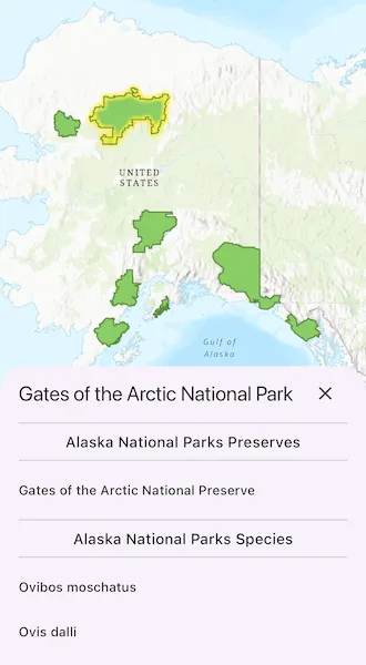
List features related to the selected feature.
Use case
Related features are useful for managing relational information, like what you would store in a relational database management system (RDBMS). You can define a relationship between records as one-to-one, one-to-many, or many-to-one. For example, you could model inspections and facilities as a many-to-one relationship. Then, for any facility feature, you could list related inspection features.
How to use the sample
Tap on a feature to select it. The related features will be displayed in a list.
How it works
- With a
Feature, callqueryRelatedFeatureson the feature’s feature table. - Iterate over the result’s collection of
RelatedFeatureQueryResultobjects to get the related features and add them to a list.
Relevant API
- ArcGISFeature
- ArcGISFeatureTable
- ArcGISFeatureTable.queryRelatedFeatures
- FeatureQueryResult
- RelatedFeatureQueryResult
Tags
features, identify, query, related, relationship, search
Sample code
query_related_features.dart
import 'dart:math';
import 'package:arcgis_maps/arcgis_maps.dart';import 'package:arcgis_maps_sdk_flutter_samples/common/common.dart';import 'package:flutter/material.dart';
class QueryRelatedFeatures extends StatefulWidget {  const QueryRelatedFeatures({super.key});
  @override  State<QueryRelatedFeatures> createState() => _QueryRelatedFeaturesState();}
class _QueryRelatedFeaturesState extends State<QueryRelatedFeatures>    with SampleStateSupport {  // Create a controller for the map view.  final _mapViewController = ArcGISMapView.createController();  // A flag for when the map view is ready and controls can be used.  var _ready = false;  // A flag for when the settings bottom sheet is visible.  var _layerDataVisible = false;  // A flag for when the features are loading.  var _loadingFeatures = false;  // Feature layer for the Alaska National Parks.  late final FeatureLayer _alaskaNationalParksLayer;  // The name of the selected park.  var _selectedParkName = '';  // Lists to store the names of the related features.  var _featurePreserves = <String>[];  var _featureSpecies = <String>[];
  @override  Widget build(BuildContext context) {    return Scaffold(      body: SafeArea(        top: false,        left: false,        right: false,        child: Stack(          children: [            // Add a map view to the widget tree and set a controller.            ArcGISMapView(              controllerProvider: () => _mapViewController,              onMapViewReady: onMapViewReady,              onTap: onTap,            ),            // Display a progress indicator and prevent interaction until state is ready.            LoadingIndicator(visible: !_ready),          ],        ),      ),      // Display the bottom sheet when the selected layer data is available.      bottomSheet: _layerDataVisible ? buildLayerData(context) : null,    );  }
  Widget buildLayerData(BuildContext context) {    return Container(      constraints: BoxConstraints(        maxHeight: MediaQuery.sizeOf(context).height * 0.4,      ),      padding: EdgeInsets.fromLTRB(        20,        5,        20,        max(          20,          View.of(context).viewPadding.bottom /              View.of(context).devicePixelRatio,        ),      ),      width: double.infinity,      child: Column(        children: [          Row(            children: [              Expanded(                child:                    _loadingFeatures                        ? const Center(child: CircularProgressIndicator())                        : Text(                          _selectedParkName,                          style: Theme.of(context).textTheme.titleLarge,                        ),              ),              IconButton(                alignment: Alignment.centerRight,                icon: const Icon(Icons.close),                onPressed: () => setState(() => _layerDataVisible = false),              ),            ],          ),          const Divider(),          Flexible(            child: SingleChildScrollView(              child: Column(                mainAxisSize: MainAxisSize.min,                children: [                  Text(                    'Alaska National Parks Preserves',                    style: Theme.of(context).textTheme.titleMedium,                  ),                  const Divider(),                  // Display the list of feature preserves for the selected park.                  for (final preserve in _featurePreserves)                    ListTile(                      dense: true,                      contentPadding: EdgeInsets.zero,                      title: Text(                        preserve,                        style: Theme.of(context).textTheme.titleSmall,                      ),                    ),                  const Divider(),                  Text(                    'Alaska National Parks Species',                    style: Theme.of(context).textTheme.titleMedium,                  ),                  const Divider(),                  // Display the list of feature species for the selected park.                  for (final species in _featureSpecies)                    ListTile(                      dense: true,                      contentPadding: EdgeInsets.zero,                      title: Text(                        species,                        style: Theme.of(context).textTheme.titleSmall,                      ),                    ),                ],              ),            ),          ),        ],      ),    );  }
  Future<void> onMapViewReady() async {    // Create a map with a topographic basemap style.    final map = ArcGISMap.withBasemapStyle(BasemapStyle.arcGISTopographic);
    // Feature table for the Alaska National Parks layer.    final alaskaNationalParksFeaturesTable = ServiceFeatureTable.withUri(      Uri.parse(        'https://services2.arcgis.com/ZQgQTuoyBrtmoGdP/ArcGIS/rest/services/AlaskaNationalParksPreservesSpecies_List/FeatureServer/1',      ),    );
    // Create parks feature layer, the origin layer in the relationship.    _alaskaNationalParksLayer = FeatureLayer.withFeatureTable(      alaskaNationalParksFeaturesTable,    );
    // Add parks feature layer to the map.    map.operationalLayers.add(_alaskaNationalParksLayer);    await _alaskaNationalParksLayer.load();
    // Create a feature table for related preserves layer.    final alaskaNationalParksPreservesTable = ServiceFeatureTable.withUri(      Uri.parse(        'https://services2.arcgis.com/ZQgQTuoyBrtmoGdP/ArcGIS/rest/services/AlaskaNationalParksPreservesSpecies_List/FeatureServer/0',      ),    );    // Create a feature table for related species layer.    final alaskaNationalParksSpeciesTable = ServiceFeatureTable.withUri(      Uri.parse(        'https://services2.arcgis.com/ZQgQTuoyBrtmoGdP/ArcGIS/rest/services/AlaskaNationalParksPreservesSpecies_List/FeatureServer/2',      ),    );    // Add these to the tables on the map.    map.tables.addAll([      alaskaNationalParksSpeciesTable,      alaskaNationalParksPreservesTable,    ]);
    // Assign map to the map view.    _mapViewController.arcGISMap =        map          ..initialViewpoint = Viewpoint.fromCenter(            ArcGISPoint(              x: -16507762.575543,              y: 9058828.127243,              spatialReference: SpatialReference.webMercator,            ),            scale: 36764077,          );
    // Set selection color.    _mapViewController.selectionProperties = SelectionProperties(      color: Colors.yellow,    );
    // Set the ready state variable to true to enable the sample UI.    setState(() => _ready = true);  }
  Future<void> onTap(Offset offset) async {    // Clear the selection on the feature layer.    _alaskaNationalParksLayer.clearSelection();
    // Do an identify on the feature layer and select a feature.    final identifyLayerResult = await _mapViewController.identifyLayer(      _alaskaNationalParksLayer,      screenPoint: offset,      tolerance: 12,    );
    // If there are features identified, show the bottom sheet to display the    // attachment information for the selected feature.    setState(() {      _selectedParkName = '';      _featurePreserves = [];      _featureSpecies = [];    });    final features =        identifyLayerResult.geoElements.whereType<Feature>().toList();    if (features.isNotEmpty) {      _alaskaNationalParksLayer.selectFeatures(features);      final selectedFeature = features.first as ArcGISFeature;      setState(() {        _layerDataVisible = true;        _loadingFeatures = true;      });      // Query for related features.      await queryRelatedFeatures(selectedFeature);    } else {      setState(() {        _layerDataVisible = false;        _loadingFeatures = false;      });    }  }
  // Query for related features given the origin feature.  Future<void> queryRelatedFeatures(ArcGISFeature selectedPark) async {    // Query for related features.    final selectedParkTable = selectedPark.featureTable! as ServiceFeatureTable;    final relatedFeatureQueryResult = await selectedParkTable        .queryRelatedFeatures(feature: selectedPark);
    // Get the related species and preserves features.    final relatedFeaturesLists = <List<String>>[];    for (final result in relatedFeatureQueryResult) {      final relatedFeatures = <String>[];      for (final feature in result.features()) {        final relatedFeature = feature as ArcGISFeature;        // Get a reference to the feature's table.        final relatedTable = feature.featureTable! as ArcGISFeatureTable;
        // Get the display field name - this is the name of the field that is intended for display.        final displayFieldName = relatedTable.layerInfo!.displayFieldName;
        // Get the display name for the feature.        final featureDisplayname = relatedFeature.attributes[displayFieldName];
        // Add the display name to the list.        relatedFeatures.add(featureDisplayname);      }      relatedFeaturesLists.add(relatedFeatures);    }
    // Update the UI with the related features.    setState(() {      _loadingFeatures = false;      _selectedParkName = selectedPark.attributes['UNIT_NAME'];
      _featurePreserves = relatedFeaturesLists[0];
      _featureSpecies = relatedFeaturesLists[1];    });  }}