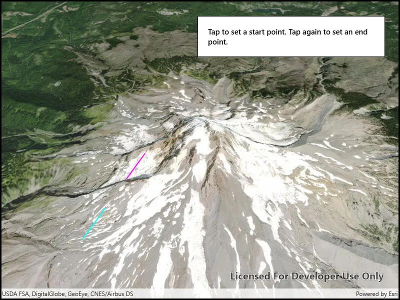
Perform a line of sight analysis between two points in real time.
Use case
A line of sight analysis can be used to assess whether a view is obstructed between an observer and a target. Obstructing features could either be natural, like topography, or man-made, like buildings. Consider an events planning company wanting to commemorate a national event by lighting sequential beacons across hill summits or roof tops. To guarantee a successful event, ensuring an unobstructed line of sight between neighboring beacons would allow each beacon to be activated as intended.
How to use the sample
Tap to place the starting point for the line. Tap again to place the end point.
How it works
- Create an
AnalysisOverlayand add it to the scene view. - Create a
LocationLineOfSightwith initial observer and target locations and add it to the analysis overlay. - Listen for taps on the scene view.
- Update the target location with
lineOfSight.TargetLocation = scenePoint.
Relevant API
- AnalysisOverlay
- LocationLineOfSight
- SceneView
Tags
3D, line of sight, visibility, visibility analysis
Sample code
<UserControl x:Class="ArcGIS.UWP.Samples.LineOfSightLocation.LineOfSightLocation" xmlns="http://schemas.microsoft.com/winfx/2006/xaml/presentation" xmlns:x="http://schemas.microsoft.com/winfx/2006/xaml" xmlns:esriUI="using:Esri.ArcGISRuntime.UI.Controls"> <Grid> <esriUI:SceneView x:Name="MySceneView" /> <Border Style="{StaticResource BorderStyle}"> <TextBlock Text="Tap to set a start point. Tap again to set an end point." TextWrapping="Wrap" FontWeight="SemiBold" /> </Border> </Grid></UserControl>// Copyright 2017 Esri.//// Licensed under the Apache License, Version 2.0 (the "License"); you may not use this file except in compliance with the License.// You may obtain a copy of the License at: http://www.apache.org/licenses/LICENSE-2.0//// Unless required by applicable law or agreed to in writing, software distributed under the License is distributed on an// "AS IS" BASIS, WITHOUT WARRANTIES OR CONDITIONS OF ANY KIND, either express or implied. See the License for the specific// language governing permissions and limitations under the License.
using Esri.ArcGISRuntime.Geometry;using Esri.ArcGISRuntime.Mapping;using Esri.ArcGISRuntime.UI.GeoAnalysis;using System;using System.Drawing;
namespace ArcGIS.UWP.Samples.LineOfSightLocation{ [ArcGIS.Samples.Shared.Attributes.Sample( name: "Line of sight (location)", category: "Analysis", description: "Perform a line of sight analysis between two points in real time.", instructions: "Tap to place the starting point for the line. Tap again to place the end point.", tags: new[] { "3D", "line of sight", "visibility", "visibility analysis" })] public sealed partial class LineOfSightLocation { // URL for an image service to use as an elevation source private string _elevationSourceUrl = @"https://elevation3d.arcgis.com/arcgis/rest/services/WorldElevation3D/Terrain3D/ImageServer";
// Location line of sight analysis private LocationLineOfSight _lineOfSightAnalysis;
// Observer location for line of sight private MapPoint _observerLocation;
// Target location for line of sight private MapPoint _targetLocation;
// Offset (meters) to use for the observer/target height (z-value for the points) private double _zOffset = 2.0;
public LineOfSightLocation() { InitializeComponent();
// Create the Scene, basemap, line of sight analysis, and analysis overlay Initialize();
// Handle taps on the scene view to define the observer or target point for the line of sight MySceneView.GeoViewTapped += SceneViewTapped; }
private void Initialize() { // Create a new Scene with an imagery basemap Scene myScene = new Scene(BasemapStyle.ArcGISImageryStandard);
// Create an elevation source for the Scene ArcGISTiledElevationSource elevationSrc = new ArcGISTiledElevationSource(new Uri(_elevationSourceUrl)); myScene.BaseSurface.ElevationSources.Add(elevationSrc);
// Add the Scene to the SceneView MySceneView.Scene = myScene;
// Set the viewpoint with a new camera Camera newCamera = new Camera(new MapPoint(-121.7, 45.4, SpatialReferences.Wgs84), 10000, 0, 45, 0); MySceneView.SetViewpointCameraAsync(newCamera);
// Create a new line of sight analysis with arbitrary points (observer and target will be defined by the user) _lineOfSightAnalysis = new LocationLineOfSight(new MapPoint(0.0, 0.0, SpatialReferences.Wgs84), new MapPoint(0.0, 0.0, SpatialReferences.Wgs84));
// Set the visible and obstructed colors (default would be green/red) // These are static properties that apply to all line of sight analyses in the scene view LineOfSight.VisibleColor = Color.Cyan; LineOfSight.ObstructedColor = Color.Magenta;
// Create an analysis overlay to contain the analysis and add it to the scene view AnalysisOverlay lineOfSightOverlay = new AnalysisOverlay(); lineOfSightOverlay.Analyses.Add(_lineOfSightAnalysis); MySceneView.AnalysisOverlays.Add(lineOfSightOverlay); }
private void SceneViewTapped(object sender, Esri.ArcGISRuntime.UI.Controls.GeoViewInputEventArgs e) { // Ignore if tapped out of bounds (e.g. the sky). if (e.Location == null) { return; }
// When the view is tapped, define the observer or target location with the tap point as appropriate if (_observerLocation == null) { // Define the observer location (plus an offset for observer height) and set the target to the same point _observerLocation = new MapPoint(e.Location.X, e.Location.Y, e.Location.Z + _zOffset); _lineOfSightAnalysis.ObserverLocation = _observerLocation; _lineOfSightAnalysis.TargetLocation = _observerLocation;
// Clear the target location (if any) so the next click will define the target _targetLocation = null; } else if (_targetLocation == null) { // Define the target _targetLocation = new MapPoint(e.Location.X, e.Location.Y, e.Location.Z + _zOffset); _lineOfSightAnalysis.TargetLocation = _targetLocation;
// Clear the observer location so it can be defined again _observerLocation = null; } } }}