Perform all map navigation operations using only the keyboard.
Use case
Use this pattern when your app must remain fully usable without a pointing device. Supporting keyboard-only pan, zoom, rotate, and identify is a core accessibility requirement for users who rely on assistive technologies or cannot use a mouse, and it also benefits users who prefer keyboard-driven workflows.
How to use the sample
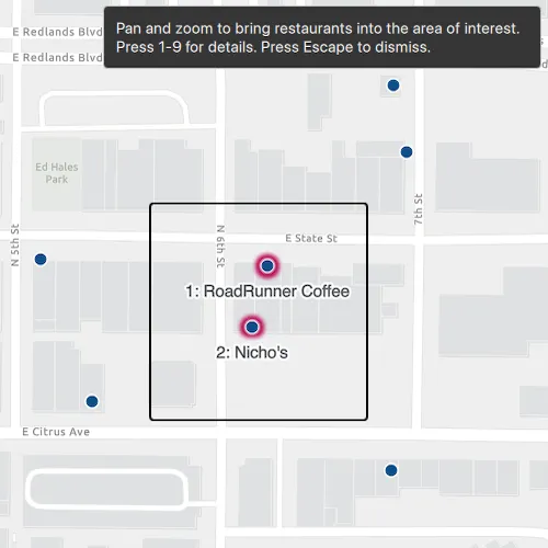
When the sample is launched, a fixed area of interest appears centered over the map, and any features inside it are automatically selected and labeled 1 – 9. As you navigate, the selection and labels update to match the features currently inside the area of interest.
Use the arrow keys to pan and + / - to zoom. Use A / D to rotate and N to reset the map to north. Press 1 – 9 to show a callout for the matching numbered feature, and press Esc to dismiss the callout.
How it works
- Create a
Mapwith a basemap and add aFeatureLayer. - Overlay a fixed-size rectangle on the
MapViewto mark the area of interest. - Connect to
MapQuickView::navigatingChangedand refresh the selection when navigation finishes. - Convert the center and edges of the rectangle to map coordinates with
MapQuickView::screenToLocation, then useGeometryEngine::distanceto construct anEnvelopefor the area of interest. - Build
QueryParameterswith the envelope geometry andSpatialRelationship::Intersects, then callServiceFeatureTable::queryFeaturesAsync. - Call
FeatureLayer::selectFeaturefor each returned feature and add numberedTextSymbolgraphics to aGraphicsOverlayfor the first nine features. - Handle
Keys.onPressedto show callouts via the number keys and to dismiss the callout on Esc.
Relevant API
- Envelope
- FeatureLayer
- Graphic
- GraphicsOverlay
- Map
- MapView
About the data
This sample uses a Redlands restaurants feature layer covering food establishments in Redlands, California. Each feature represents a single restaurant.
Additional information
The map view supports built-in keyboard shortcuts for pan (arrow keys), zoom (+ / -), rotate (A / D), and reset to north (N). See Navigate a map view for the complete list of built-in interactions.
Tags
accessibility, accessible, identify, inclusive, input, interaction, keyboard, navigation, selection, WCAG
Sample code
// [WriteFile Name=NavigateMapViewAndIdentifyFeaturesWithKeyboard, Category=Accessibility]// [Legal]// Copyright 2026 Esri.//// Licensed under the Apache License, Version 2.0 (the "License");// you may not use this file except in compliance with the License.// You may obtain a copy of the License at// http://www.apache.org/licenses/LICENSE-2.0//// Unless required by applicable law or agreed to in writing, software// distributed under the License is distributed on an "AS IS" BASIS,// WITHOUT WARRANTIES OR CONDITIONS OF ANY KIND, either express or implied.// See the License for the specific language governing permissions and// limitations under the License.// [Legal]
#ifdef PCH_BUILD#include "pch.hpp"#endif // PCH_BUILD
// sample headers#include "NavigateMapViewAndIdentifyFeaturesWithKeyboard.h"
// ArcGIS Maps SDK headers#include "AttributeListModel.h"#include "CalloutData.h"#include "CoreTypes.h"#include "Envelope.h"#include "Feature.h"#include "FeatureIterator.h"#include "FeatureLayer.h"#include "FeatureQueryResult.h"#include "GeodatabaseTypes.h"#include "GeometryEngine.h"#include "Graphic.h"#include "GraphicListModel.h"#include "GraphicsOverlay.h"#include "GraphicsOverlayListModel.h"#include "LayerListModel.h"#include "Map.h"#include "MapQuickView.h"#include "MapTypes.h"#include "MapViewTypes.h"#include "Point.h"#include "QueryParameters.h"#include "SelectionProperties.h"#include "ServiceFeatureTable.h"#include "SimpleLineSymbol.h"#include "SimpleMarkerSymbol.h"#include "SimpleRenderer.h"#include "SpatialReference.h"#include "SymbolTypes.h"#include "TextSymbol.h"#include "Viewpoint.h"
// Qt headers#include <QColor>#include <QFuture>#include <QPointF>#include <QUrl>
// STL headers#include <algorithm>
using namespace Esri::ArcGISRuntime;
// Colors used for the marker, selection halo, and label.static constexpr QColor markerFill{11, 79, 138};static constexpr QColor selectionHalo{190, 24, 93};static constexpr QColor labelText{31, 35, 40};
NavigateMapViewAndIdentifyFeaturesWithKeyboard::NavigateMapViewAndIdentifyFeaturesWithKeyboard(QObject* parent) :  QObject(parent),  m_map(new Map(BasemapStyle::ArcGISLightGray, this)),  m_restaurantsTable(new ServiceFeatureTable(QUrl("https://services2.arcgis.com/ZQgQTuoyBrtmoGdP/arcgis/rest/services/"                                                  "redlands_food/FeatureServer/0"),                                             this)),  m_restaurantsLayer(new FeatureLayer(m_restaurantsTable, this)),  m_labelsOverlay(new GraphicsOverlay(this)){  SimpleMarkerSymbol* restaurantSymbol = new SimpleMarkerSymbol(SimpleMarkerSymbolStyle::Circle, markerFill, 12.0F, this);  SimpleLineSymbol* restaurantOutline = new SimpleLineSymbol(SimpleLineSymbolStyle::Solid, Qt::white, 1.5F, this);  restaurantSymbol->setOutline(restaurantOutline);  m_restaurantsLayer->setRenderer(new SimpleRenderer(restaurantSymbol, this));
  const Point redlandsCenter(-117.1825, 34.0556, SpatialReference::wgs84());  m_map->setInitialViewpoint(Viewpoint(redlandsCenter, 2500.0));  m_map->operationalLayers()->append(m_restaurantsLayer);}
NavigateMapViewAndIdentifyFeaturesWithKeyboard::~NavigateMapViewAndIdentifyFeaturesWithKeyboard() = default;
void NavigateMapViewAndIdentifyFeaturesWithKeyboard::init(){  // Register the map view for QML  qmlRegisterType<MapQuickView>("Esri.Samples", 1, 0, "MapView");  qmlRegisterType<NavigateMapViewAndIdentifyFeaturesWithKeyboard>("Esri.Samples", 1, 0, "NavigateMapViewAndIdentifyFeaturesWithKeyboardSample");}
MapQuickView* NavigateMapViewAndIdentifyFeaturesWithKeyboard::mapView() const{  return m_mapView;}
// Set the view (created in QML)void NavigateMapViewAndIdentifyFeaturesWithKeyboard::setMapView(MapQuickView* mapView){  if (!mapView || mapView == m_mapView)  {    return;  }
  m_mapView = mapView;  m_mapView->setMap(m_map);  m_mapView->setSelectionProperties(SelectionProperties(selectionHalo));  m_mapView->graphicsOverlays()->append(m_labelsOverlay);
  // Wait until navigation stops before finding features in the updated view.  connect(m_mapView, &MapQuickView::navigatingChanged, this, [this]()  {    if (m_mapView->isNavigating())    {      if (m_queryInProgress)      {        m_refreshPending = true;      }      return;    }
    if (calloutIsVisible())    {      m_refreshPending = true;      if (!calloutIsInView())      {        dismissCallout();      }      return;    }
    identifyFeatures();  });  // Run the first query after the map has finished drawing.  connect(m_mapView, &MapQuickView::drawStatusChanged, this, [this](DrawStatus drawStatus)  {    if (drawStatus == DrawStatus::Completed && !m_initialDrawCompleted)    {      m_initialDrawCompleted = true;      identifyFeatures();    }  });  emit mapViewChanged();}
double NavigateMapViewAndIdentifyFeaturesWithKeyboard::areaOfInterestSize() const{  return m_areaOfInterestSize;}
void NavigateMapViewAndIdentifyFeaturesWithKeyboard::setAreaOfInterestSize(double size){  if (qFuzzyCompare(m_areaOfInterestSize, size))  {    return;  }
  m_areaOfInterestSize = size;  emit areaOfInterestSizeChanged();  identifyFeatures();}
bool NavigateMapViewAndIdentifyFeaturesWithKeyboard::overflowVisible() const{  return m_overflowVisible;}
QString NavigateMapViewAndIdentifyFeaturesWithKeyboard::errorMessage() const{  return m_errorMessage;}
void NavigateMapViewAndIdentifyFeaturesWithKeyboard::identifyFeatures(){  if (!m_mapView || m_mapView->width() <= 0.0 || m_mapView->height() <= 0.0 || m_areaOfInterestSize <= 0.0)  {    return;  }
  // Keep the current callout stable and refresh after it is dismissed.  if (calloutIsVisible())  {    m_refreshPending = true;    return;  }
  // Queue one refresh instead of starting overlapping queries.  if (m_queryInProgress)  {    m_refreshPending = true;    return;  }
  // Convert the on-screen square into a map envelope for the feature query.  const double halfSize = m_areaOfInterestSize / 2.0;  const double centerX = m_mapView->width() / 2.0;  const double centerY = m_mapView->height() / 2.0;  const Point center = m_mapView->screenToLocation(centerX, centerY);  const Point horizontalEdge = m_mapView->screenToLocation(centerX + halfSize, centerY);  const Point verticalEdge = m_mapView->screenToLocation(centerX, centerY + halfSize);  if (!center.isValid() || !horizontalEdge.isValid() || !verticalEdge.isValid())  {    return;  }
  const double width = GeometryEngine::distance(center, horizontalEdge) * 2.0;  const double height = GeometryEngine::distance(center, verticalEdge) * 2.0;  const Envelope areaOfInterest(center, width, height);
  QueryParameters parameters;  parameters.setGeometry(GeometryEngine::normalizeCentralMeridian(areaOfInterest));  parameters.setSpatialRelationship(SpatialRelationship::Intersects);  parameters.setReturnGeometry(true);
  clearSelection();  m_queryInProgress = true;  setErrorMessage(QString());  QFuture<FeatureQueryResult*> queryFuture = m_restaurantsTable->queryFeaturesAsync(parameters, QueryFeatureFields::LoadAll, this);  queryFuture    .then(this,          [this](FeatureQueryResult* queryResult)  {    if (calloutIsVisible())    {      m_queryInProgress = false;      m_refreshPending = true;      if (queryResult)      {        queryResult->deleteLater();      }      return;    }    if (m_refreshPending)    {      // Discard results for an old view and query the latest view instead.      m_queryInProgress = false;      m_refreshPending = false;      if (queryResult)      {        queryResult->deleteLater();      }      identifyFeatures();      return;    }
    processQueryResult(queryResult);    m_queryInProgress = false;    if (m_refreshPending)    {      m_refreshPending = false;      identifyFeatures();    }  })    .onFailed(this, [this](const std::exception& exception)  {    m_queryInProgress = false;    if (calloutIsVisible())    {      m_refreshPending = true;      return;    }    if (m_refreshPending)    {      m_refreshPending = false;      identifyFeatures();      return;    }    setErrorMessage(QString::fromUtf8(exception.what()));  });}
void NavigateMapViewAndIdentifyFeaturesWithKeyboard::processQueryResult(FeatureQueryResult* queryResult){  if (!queryResult)  {    return;  }
  struct OrderedFeature  {    Feature* feature = nullptr;    QPointF screenPoint;  };
  QVector<OrderedFeature> orderedFeatures;  FeatureIterator iterator = queryResult->iterator();  while (iterator.hasNext())  {    Feature* feature = iterator.next(this);    const Point point(feature->geometry());    if (!point.isValid())    {      feature->deleteLater();      continue;    }
    orderedFeatures.append({feature, m_mapView->locationToScreen(point)});  }
  // Number features from top to bottom, then from left to right.  std::sort(orderedFeatures.begin(), orderedFeatures.end(), [](const OrderedFeature& first, const OrderedFeature& second)  {    return first.screenPoint.y() == second.screenPoint.y() ? first.screenPoint.x() < second.screenPoint.x() :                                                             first.screenPoint.y() < second.screenPoint.y();  });
  const bool overflowVisible = orderedFeatures.size() > 9;  for (qsizetype index = 0; index < orderedFeatures.size(); ++index)  {    Feature* feature = orderedFeatures.at(index).feature;    m_identifiedFeatures.append(feature);    m_restaurantsLayer->selectFeature(feature);    // Only the first nine features can be reached with the number keys.    if (index >= 9)    {      continue;    }
    const QString name = featureName(feature);    const QString label = name.isEmpty() ? QString::number(index + 1) : QString("%1: %2").arg(index + 1).arg(name);    TextSymbol* textSymbol = new TextSymbol(label, labelText, 15.0F, HorizontalAlignment::Center, VerticalAlignment::Top, this);    textSymbol->setHaloColor(Qt::white);    textSymbol->setHaloWidth(2.0F);    textSymbol->setOffsetY(-14.0F);    Graphic* labelGraphic = new Graphic(feature->geometry(), textSymbol, this);    textSymbol->setParent(labelGraphic);    m_labelsOverlay->graphics()->append(labelGraphic);  }
  if (m_overflowVisible != overflowVisible)  {    m_overflowVisible = overflowVisible;    emit overflowVisibleChanged();  }
  queryResult->deleteLater();}
void NavigateMapViewAndIdentifyFeaturesWithKeyboard::clearSelection(){  m_restaurantsLayer->clearSelection();  // Remove the old number labels before creating labels for the next query.  QList<Graphic*> labelGraphics;  labelGraphics.reserve(m_labelsOverlay->graphics()->size());  for (int index = 0; index < m_labelsOverlay->graphics()->size(); ++index)  {    labelGraphics.append(m_labelsOverlay->graphics()->at(index));  }  m_labelsOverlay->graphics()->clear();  for (Graphic* labelGraphic : std::as_const(labelGraphics))  {    labelGraphic->deleteLater();  }
  if (m_overflowVisible)  {    m_overflowVisible = false;    emit overflowVisibleChanged();  }
  qDeleteAll(m_identifiedFeatures);  m_identifiedFeatures.clear();}
bool NavigateMapViewAndIdentifyFeaturesWithKeyboard::calloutIsVisible() const{  return m_mapView && m_mapView->calloutData()->isVisible();}
bool NavigateMapViewAndIdentifyFeaturesWithKeyboard::calloutIsInView() const{  if (!calloutIsVisible())  {    return false;  }
  const QPointF screenPoint = m_mapView->calloutData()->screenPoint();  return screenPoint.x() >= 0.0 && screenPoint.x() <= m_mapView->width() && screenPoint.y() >= 0.0 && screenPoint.y() <= m_mapView->height();}
QString NavigateMapViewAndIdentifyFeaturesWithKeyboard::featureName(Feature* feature) const{  const QStringList attributeNames = feature->attributes()->attributeNames();  for (const QString& attributeName : attributeNames)  {    if (attributeName.compare("name", Qt::CaseInsensitive) == 0)    {      return feature->attributes()->attributeValue(attributeName).toString().trimmed();    }  }  return {};}
bool NavigateMapViewAndIdentifyFeaturesWithKeyboard::showCallout(int featureNumber){  // Convert keys 1-9 into indexes 0-8 in the sorted feature list.  const int featureIndex = featureNumber - 1;  if (!m_mapView || featureIndex < 0 || featureIndex >= 9 || featureIndex >= m_identifiedFeatures.size() || !m_identifiedFeatures.at(featureIndex))  {    return false;  }
  Feature* feature = m_identifiedFeatures.at(featureIndex);  CalloutData* calloutData = m_mapView->calloutData();  const QString name = featureName(feature);  const Point featureLocation(feature->geometry());  const Point location(GeometryEngine::project(feature->geometry(), SpatialReference::wgs84()));  if (!featureLocation.isValid() || !location.isValid())  {    return false;  }
  // Move the leader slightly above the marker so the callout does not cover it.  const QPointF screenPoint = m_mapView->locationToScreen(featureLocation);  const Point leaderLocation = m_mapView->screenToLocation(screenPoint.x(), screenPoint.y() - 4.0);  calloutData->setLocation(leaderLocation.isValid() ? leaderLocation : featureLocation);  calloutData->setTitle(name.isEmpty() ? tr("Restaurant") : name);  calloutData->setDetail(tr("Lat: %1\nLon: %2").arg(location.y(), 0, 'f', 6).arg(location.x(), 0, 'f', 6));  calloutData->setVisible(true);  return true;}
void NavigateMapViewAndIdentifyFeaturesWithKeyboard::dismissCallout(){  if (!m_mapView)  {    return;  }
  m_mapView->calloutData()->setVisible(false);  if (m_refreshPending)  {    m_refreshPending = false;    identifyFeatures();  }}
void NavigateMapViewAndIdentifyFeaturesWithKeyboard::setErrorMessage(const QString& message){  if (m_errorMessage == message)  {    return;  }
  m_errorMessage = message;  emit errorMessageChanged();}
// [WriteFile Name=NavigateMapViewAndIdentifyFeaturesWithKeyboard, Category=Accessibility]// [Legal]// Copyright 2026 Esri.//// Licensed under the Apache License, Version 2.0 (the "License");// you may not use this file except in compliance with the License.// You may obtain a copy of the License at// http://www.apache.org/licenses/LICENSE-2.0//// Unless required by applicable law or agreed to in writing, software// distributed under the License is distributed on an "AS IS" BASIS,// WITHOUT WARRANTIES OR CONDITIONS OF ANY KIND, either express or implied.// See the License for the specific language governing permissions and// limitations under the License.// [Legal]
#ifndef NAVIGATEMAPVIEWANDIDENTIFYFEATURESWITHKEYBOARD_H#define NAVIGATEMAPVIEWANDIDENTIFYFEATURESWITHKEYBOARD_H
// Qt headers#include <QObject>#include <QVector>
namespace Esri::ArcGISRuntime{ class Feature; class FeatureLayer; class FeatureQueryResult; class GraphicsOverlay; class Map; class MapQuickView; class ServiceFeatureTable;} // namespace Esri::ArcGISRuntime
Q_MOC_INCLUDE("MapQuickView.h");
class NavigateMapViewAndIdentifyFeaturesWithKeyboard : public QObject{ Q_OBJECT
Q_PROPERTY(Esri::ArcGISRuntime::MapQuickView* mapView READ mapView WRITE setMapView NOTIFY mapViewChanged) Q_PROPERTY(double areaOfInterestSize READ areaOfInterestSize WRITE setAreaOfInterestSize NOTIFY areaOfInterestSizeChanged) Q_PROPERTY(bool overflowVisible READ overflowVisible NOTIFY overflowVisibleChanged) Q_PROPERTY(QString errorMessage READ errorMessage NOTIFY errorMessageChanged)
public: explicit NavigateMapViewAndIdentifyFeaturesWithKeyboard(QObject* parent = nullptr); ~NavigateMapViewAndIdentifyFeaturesWithKeyboard() override;
static void init();
Q_INVOKABLE bool showCallout(int featureNumber); Q_INVOKABLE void dismissCallout();
signals: void mapViewChanged(); void areaOfInterestSizeChanged(); void overflowVisibleChanged(); void errorMessageChanged();
private: Esri::ArcGISRuntime::MapQuickView* mapView() const; void setMapView(Esri::ArcGISRuntime::MapQuickView* mapView); double areaOfInterestSize() const; void setAreaOfInterestSize(double size); bool overflowVisible() const; QString errorMessage() const;
void identifyFeatures(); void processQueryResult(Esri::ArcGISRuntime::FeatureQueryResult* queryResult); void clearSelection(); bool calloutIsVisible() const; bool calloutIsInView() const; QString featureName(Esri::ArcGISRuntime::Feature* feature) const; void setErrorMessage(const QString& message);
Esri::ArcGISRuntime::Map* m_map = nullptr; Esri::ArcGISRuntime::MapQuickView* m_mapView = nullptr; Esri::ArcGISRuntime::ServiceFeatureTable* m_restaurantsTable = nullptr; Esri::ArcGISRuntime::FeatureLayer* m_restaurantsLayer = nullptr; Esri::ArcGISRuntime::GraphicsOverlay* m_labelsOverlay = nullptr; QVector<Esri::ArcGISRuntime::Feature*> m_identifiedFeatures; double m_areaOfInterestSize = 200.0; bool m_queryInProgress = false; bool m_refreshPending = false; bool m_initialDrawCompleted = false; bool m_overflowVisible = false; QString m_errorMessage;};
#endif // NAVIGATEMAPVIEWANDIDENTIFYFEATURESWITHKEYBOARD_H// [WriteFile Name=NavigateMapViewAndIdentifyFeaturesWithKeyboard, Category=Accessibility]// [Legal]// Copyright 2026 Esri.
// Licensed under the Apache License, Version 2.0 (the "License");// you may not use this file except in compliance with the License.// You may obtain a copy of the License at// http://www.apache.org/licenses/LICENSE-2.0
// Unless required by applicable law or agreed to in writing, software// distributed under the License is distributed on an "AS IS" BASIS,// WITHOUT WARRANTIES OR CONDITIONS OF ANY KIND, either express or implied.// See the License for the specific language governing permissions and// limitations under the License.// [Legal]
import QtQuickimport QtQuick.Controlsimport Esri.ArcGISRuntime.Toolkitimport Esri.Samples
Item { id: root
readonly property real spacing: 12 readonly property real areaSize: Math.max(0, Math.min(200, width - spacing * 2, mapContainer.height - spacing * 2))
Item { id: mapContainer anchors.fill: parent
MapView { id: view anchors.fill: parent focus: true
Keys.priority: Keys.BeforeItem Keys.onPressed: event => { if (event.key === Qt.Key_Escape) { if (view.calloutData.visible) model.dismissCallout(); event.accepted = true; } else if (event.key >= Qt.Key_1 && event.key <= Qt.Key_9) { event.accepted = model.showCallout(event.key - Qt.Key_0); } }
Component.onCompleted: forceActiveFocus() }
Rectangle { anchors.centerIn: parent visible: !view.calloutData.visible width: root.areaSize height: root.areaSize color: "transparent" border { color: "black" width: 2 } radius: 4 } }
Pane { id: instructions anchors { top: parent.top right: parent.right margins: root.spacing } width: Math.max(0, Math.min(400, root.width - root.spacing * 2)) padding: root.spacing
Column { width: parent.width spacing: 6
Label { width: parent.width wrapMode: Text.Wrap text: qsTr("Pan and zoom to bring restaurants into the area of interest. Press 1-9 for details. Press Escape to dismiss.") }
Label { width: parent.width visible: model.overflowVisible wrapMode: Text.Wrap color: "#be185d" text: qsTr("Too many features in the area. Zoom in to see fewer.") }
Label { width: parent.width visible: model.errorMessage.length > 0 wrapMode: Text.Wrap textFormat: Text.PlainText color: "red" text: model.errorMessage } } }
NavigateMapViewAndIdentifyFeaturesWithKeyboardSample { id: model mapView: view areaOfInterestSize: root.areaSize }
Callout { z: 1 calloutData: view.calloutData accessoryButtonVisible: false leaderPosition: Callout.LeaderPosition.Automatic }}