Learn how to search for places of interest, such as hotels, cafes, and gas stations using the geocoding service.
Geocoding is the process of transforming an address or place name to a location on the earth's surface. A geocoding service allows you to quickly find places that meet specific criteria.
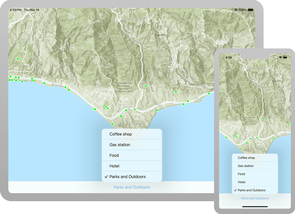
In this tutorial, you use a picklist in the user interface to select a category of places, for example, coffee shops or gas stations. You locate all the places that match this category by accessing a geocoding service. The places are displayed on the map so that you can click on them to get further information.
Prerequisites
The following are required for this tutorial:
- An ArcGIS account to access your API keys. If you don't have an account, sign up for free.
- Your system meets the system requirements.
Steps
Open the Xcode project
-
To start the tutorial, complete the Display a map tutorial or download and unzip the solution.
-
Open the
.xcodeprojfile in Xcode. -
If you downloaded the solution project, set your API key.
An API Key enables access to services, web maps, and web scenes hosted in ArcGIS Online.
-
Go to your developer dashboard to get your API key. For these tutorials, use your default API key. It is scoped to include all of the services demonstrated in the tutorials.
- In Xcode, in the Project Navigator, click MainApp.swift.
- In the Editor, set the
ArcGISEnvironment.apiKeyproperty on theArcGISEnvironmentwith your API key.
MainApp.swiftUse dark colors for code blocks import SwiftUI import ArcGIS @main struct MainApp: App { init() { ArcGISEnvironment.apiKey = APIKey("<#your-API-key#>") } var body: some SwiftUI.Scene { WindowGroup { ContentView() .ignoresSafeArea() } } } -
Update the map
-
In Xcode, in the Project Navigator, click ContentView.swift.
-
Create a private extension of
Contentand make a private class namedView Modelof typeObservable. Add aObject @Statevariable of theObject Modelto theContent. See the programming patterns page for more information on how to manage states.View ContentView.swiftUse dark colors for code blocks Add line. Add line. Add line. Add line. Add line. Add line. Add line. Add line. struct ContentView: View { @StateObject private var model = Model() @State private var map = { let map = Map(basemapStyle: .arcGISTopographic) map.initialViewpoint = Viewpoint(latitude: 34.02700, longitude: -118.80500, scale: 72_000) return map }() } private extension ContentView { private class Model: ObservableObject { } } -
Create a
GraphicsOverlaynamedgraphicsin theOverlay Modelclass. A graphics overlay is a container for graphics.A graphics overlay is a container for graphics. It is used with a map view to display graphics on a map. You can add more than one graphics overlay to a map view. Graphics overlays are displayed on top of all the other layers.
ContentView.swiftUse dark colors for code blocks Add line. private class Model: ObservableObject { let graphicsOverlay = GraphicsOverlay() } -
Add the graphics overlay to the map view, wrap the map view inside a
MapViewReader, and expose theMapViewProxyclass in its closure.Mapprovides operations that can be performed on the map view, such as 'identify'. For more information see Perform GeoView operations.View Proxy ContentView.swiftUse dark colors for code blocks Add line. Add line. Add line. Add line. Add line. var body: some View { MapViewReader { mapViewProxy in MapView(map: map, graphicsOverlays: [model.graphicsOverlay]) } }
Set up the LocatorTask
A locator task is used to search for places using a geocoding service. Results from this search contain the place location and additional information (attributes). Create the locator task along with any variables and methods needed to perform the search and display the results.
-
In the Model, create a
LocatorTaskproperty namedlocatorusing the Geocoding service URL.A locator task is used to convert an address to a point (geocode) or vice-versa (reverse geocode). An address includes any type of information that distinguishes a place. A locator involves finding matching locations for a given address. Reverse-geocoding is the opposite and finds the closest address for a given point.
ContentView.swiftUse dark colors for code blocks Add line. Add line. Add line. private extension ContentView { private class Model: ObservableObject { let graphicsOverlay = GraphicsOverlay() let locator = LocatorTask( url: URL(string: "https://geocode-api.arcgis.com/arcgis/rest/services/World/GeocodeServer")! ) } } -
To support the geocode operation, create an
enumnamedCategoryin theContentextension. Provide aView Stringnamed "label" and aUIColornamed "color". Each category is searched using itslabeland is distinguished on the map using its associatedcolor.This tutorial uses category filtering to provide accurate search results based on pre-determined place categories. Feel free to modify this list to your specific requirements.
ContentView.swiftUse dark colors for code blocks Add line. Add line. Add line. Add line. Add line. Add line. Add line. Add line. Add line. Add line. Add line. Add line. Add line. Add line. Add line. Add line. Add line. Add line. Add line. Add line. Add line. Add line. Add line. private extension ContentView { enum Category: CaseIterable, Equatable { case coffeeShop, gasStation, food, hotel, parksOutdoors var label: String { switch self { case .coffeeShop: return "Coffee shop" case .gasStation: return "Gas station" case .food: return "Food" case .hotel: return "Hotel" case .parksOutdoors: return "Parks and Outdoors" } } var color: UIColor { switch self { case .coffeeShop: return .brown case .gasStation: return .orange case .food: return .purple case .hotel: return .blue case .parksOutdoors: return .green } } } private class Model: ObservableObject { let graphicsOverlay = GraphicsOverlay() let locator = LocatorTask( url: URL(string: "https://geocode-api.arcgis.com/arcgis/rest/services/World/GeocodeServer")! ) } } -
In the
Contentstruct, create a private variable namedView geoof typeView Extent Envelopewith the@Stateproperty wrapper. This will be used to define the search location.ContentView.swiftUse dark colors for code blocks Add line. struct ContentView: View { @StateObject private var model = Model() @State private var geoViewExtent: Envelope? @State private var map = { let map = Map(basemapStyle: .arcGISTopographic) map.initialViewpoint = Viewpoint(latitude: 34.02700, longitude: -118.80500, scale: 72_000) return map }() var body: some View { MapViewReader { mapViewProxy in MapView(map: map, graphicsOverlays: [model.graphicsOverlay]) } } } -
In the
body, add theomethod to the map view. Set then Visible Area Changed(perform: ) geovariable to the new visible area's extent.View Extent ContentView.swiftUse dark colors for code blocks Add line. Add line. Add line. var body: some View { MapViewReader { mapViewProxy in MapView(map: map, graphicsOverlays: [model.graphicsOverlay]) .onVisibleAreaChanged { newVisibleArea in geoViewExtent = newVisibleArea.extent } } } -
In the
Model, create a private, asynchronous method calledfindto perform the geocode search operation. The method takes a parameter of typePlaces(for Category: search Point: ) Categorythat you created in the previous step to indicate which category of places to search for and aPointthat acts as the preferred search location.ContentView.swiftUse dark colors for code blocks Add line. Add line. Add line. private class Model: ObservableObject { let graphicsOverlay = GraphicsOverlay() let locator = LocatorTask( url: URL(string: "https://geocode-api.arcgis.com/arcgis/rest/services/World/GeocodeServer")! ) func findPlaces(forCategory category: Category, searchPoint: Point? = nil) async { } } -
Clear the previous results by removing all graphics from the graphics overlay. Create and configure new
Geocode. Populate them with theParameters searchparameter as the search location and add result attribute names.Point ContentView.swiftUse dark colors for code blocks Add line. Add line. Add line. Add line. func findPlaces(forCategory category: Category, searchPoint: Point? = nil) async { graphicsOverlay.removeAllGraphics() let geocodeParameters = GeocodeParameters() geocodeParameters.preferredSearchLocation = searchPoint geocodeParameters.addResultAttributeNames(["Place_addr", "PlaceName"]) } -
Perform the search query using
geocode(for. Pass in the category'sSearch Text: using: ) labeland the geocode parameters.ContentView.swiftUse dark colors for code blocks Add line. Add line. Add line. Add line. Add line. Add line. func findPlaces(forCategory category: Category, searchPoint: Point? = nil) async { graphicsOverlay.removeAllGraphics() let geocodeParameters = GeocodeParameters() geocodeParameters.preferredSearchLocation = searchPoint geocodeParameters.addResultAttributeNames(["Place_addr", "PlaceName"]) do { let geocodeResults = try await locator.geocode(forSearchText: category.label, using: geocodeParameters) } catch { print(error) } } -
Create graphics for each of the results and add them to the graphics overlay.
Populate the
graphicswithOverlay SimpleMarkerSymbols representing each place returned in the search results. This is very similar to the Add a point, line, and polygon tutorial.ContentView.swiftUse dark colors for code blocks Add line. Add line. Add line. Add line. Add line. Add line. Add line. Add line. Add line. Add line. Add line. Add line. Add line. Add line. func findPlaces(forCategory category: Category, searchPoint: Point? = nil) async { graphicsOverlay.removeAllGraphics() let geocodeParameters = GeocodeParameters() geocodeParameters.preferredSearchLocation = searchPoint geocodeParameters.addResultAttributeNames(["Place_addr", "PlaceName"]) do { let geocodeResults = try await locator.geocode(forSearchText: category.label, using: geocodeParameters) if !geocodeResults.isEmpty { let placeSymbol = SimpleMarkerSymbol( style: .circle, color: category.color, size: 10 ) placeSymbol.outline = SimpleLineSymbol( style: .solid, color: .white, width: 2 ) let graphics = geocodeResults.map { Graphic(geometry: $0.displayLocation, attributes: $0.attributes, symbol: placeSymbol) } graphicsOverlay.addGraphics(graphics) } } catch { print(error) } }
Add a category picker
You will add a Picker to the user interface to show categories of places to find, for example, coffee shops or gas stations. Each category will be displayed with a different color on the map.
-
In the
Contentstruct, add a variable of typeView Categorywith the@Stateproperty wrapper and give it a default value ofcoffee. This will indicate the currently selected category.Shop ContentView.swiftUse dark colors for code blocks Add line. struct ContentView: View { @StateObject private var model = Model() @State private var geoViewExtent: Envelope? @State private var selectedCategory: Category = .coffeeShop @State private var map = { let map = Map(basemapStyle: .arcGISTopographic) map.initialViewpoint = Viewpoint(latitude: 34.02700, longitude: -118.80500, scale: 72_000) return map }() -
In the
ContentView body, add atoolbarview modifier to the map view that places aToolbarat the bottom of the view where thePickerwill be contained.ContentView.swiftUse dark colors for code blocks Add line. Add line. Add line. Add line. Add line. var body: some View { MapViewReader { mapViewProxy in MapView(map: map, graphicsOverlays: [model.graphicsOverlay]) .onVisibleAreaChanged { newVisibleArea in geoViewExtent = newVisibleArea.extent } .toolbar { ToolbarItemGroup(placement: .bottomBar) { } } } } -
Add a
Pickerto the toolbar and label it "Choose a category". Set the selection to$selected. This will iterate throughCategory .allofCases Categoryto populate the Picker with all the category labels. Add the.labelsmodifier.Hidden ContentView.swiftUse dark colors for code blocks Add line. Add line. Add line. Add line. Add line. Add line. .toolbar { ToolbarItemGroup(placement: .bottomBar) { Picker("Choose a category", selection: $selectedCategory) { ForEach(Category.allCases, id: \.self) { category in Text(category.label) } } .labelsHidden() } } -
Lastly, add a
.taskmodifier to thePickerthat calls the model'sfindfunction. Pass inPlaces(for Category: search Point: ) selectedand theCategory geo. This will initiate a geocode search when a category is selected.View Extent?.center ContentView.swiftUse dark colors for code blocks Add line. Add line. Add line. .toolbar { ToolbarItemGroup(placement: .bottomBar) { Picker("Choose a category", selection: $selectedCategory) { ForEach(Category.allCases, id: \.self) { category in Text(category.label) } } .labelsHidden() .task(id: selectedCategory) { await model.findPlaces(forCategory: selectedCategory, searchPoint: geoViewExtent?.center) } } }
Show information about a tapped location in the map
An identify operation can be used to get information about a geoelement (such as a graphic) at a location where the user has tapped on the map. A callout can be used to display this information.
-
In the
Contentstruct, add objects to track the map and screen locations. CreateView PointandCGPointvariables with the@Stateproperty wrappers. Name themmapandLocation tap, respectively.Location ContentView.swiftUse dark colors for code blocks Add line. Add line. struct ContentView: View { @StateObject private var model = Model() @State private var geoViewExtent: Envelope? @State private var selectedCategory: Category = .coffeeShop @State private var tapLocation: CGPoint? @State private var mapLocation: Point? @State private var map = { let map = Map(basemapStyle: .arcGISTopographic) map.initialViewpoint = Viewpoint(latitude: 34.02700, longitude: -118.80500, scale: 72_000) return map }() -
Add objects to support the callout. Create
CalloutandPlacement Stringvariables with the@Stateproperty wrapper. Name themcalloutandPlacement calloutrespectively.Text ContentView.swiftUse dark colors for code blocks Add line. Add line. struct ContentView: View { @StateObject private var model = Model() @State private var geoViewExtent: Envelope? @State private var selectedCategory: Category = .coffeeShop @State private var tapLocation: CGPoint? @State private var mapLocation: Point? @State private var calloutPlacement: CalloutPlacement? @State private var calloutText: String? @State private var map = { let map = Map(basemapStyle: .arcGISTopographic) map.initialViewpoint = Viewpoint(latitude: 34.02700, longitude: -118.80500, scale: 72_000) return map }() -
In the
body, add a.calloutmodifier to the map view. Pass in$calloutas the placement parameter. In the closure, create aPlacement Textobject using thecalloutand provide a defaultText Stringin case it is nil.ContentView.swiftUse dark colors for code blocks Add line. Add line. Add line. Add line. Add line. Add line. var body: some View { MapViewReader { mapViewProxy in MapView(map: map, graphicsOverlays: [model.graphicsOverlay]) .callout(placement: $calloutPlacement.animation(.default.speed(2))) { _ in Text(calloutText ?? "No address found.") .font(.callout) .padding(8) .frame(maxWidth: 350) } .onVisibleAreaChanged { newVisibleArea in geoViewExtent = newVisibleArea.extent } .toolbar { ToolbarItemGroup(placement: .bottomBar) { Picker("Choose a category", selection: $selectedCategory) { ForEach(Category.allCases, id: \.self) { category in Text(category.label) } } .labelsHidden() .task(id: selectedCategory) { await model.findPlaces(forCategory: selectedCategory, searchPoint: geoViewExtent?.center) } } } } } -
Add the
omethod to the map view and setn Single T a p Gesture(perform: ) mapandLocation tap.Location ContentView.swiftUse dark colors for code blocks Add line. Add line. Add line. Add line. var body: some View { MapViewReader { mapViewProxy in MapView(map: map, graphicsOverlays: [model.graphicsOverlay]) .callout(placement: $calloutPlacement.animation(.default.speed(2))) { _ in Text(calloutText ?? "No address found.") .font(.callout) .padding(8) .frame(maxWidth: 350) } .onVisibleAreaChanged { newVisibleArea in geoViewExtent = newVisibleArea.extent } .onSingleTapGesture { screenPoint, mapPoint in tapLocation = screenPoint mapLocation = mapPoint } .toolbar { ToolbarItemGroup(placement: .bottomBar) { Picker("Choose a category", selection: $selectedCategory) { ForEach(Category.allCases, id: \.self) { category in Text(category.label) } } .labelsHidden() .task(id: selectedCategory) { await model.findPlaces(forCategory: selectedCategory, searchPoint: geoViewExtent?.center) } } } } } -
Add a
.taskmodifier to the map view, passing intapas the idefntifier. Ensure that the location objects are not nil.Location ContentView.swiftUse dark colors for code blocks Add line. Add line. Add line. Add line. var body: some View { MapViewReader { mapViewProxy in MapView(map: map, graphicsOverlays: [model.graphicsOverlay]) .callout(placement: $calloutPlacement.animation(.default.speed(2))) { _ in Text(calloutText ?? "No address found.") .font(.callout) .padding(8) .frame(maxWidth: 350) } .onVisibleAreaChanged { newVisibleArea in geoViewExtent = newVisibleArea.extent } .onSingleTapGesture { screenPoint, mapPoint in tapLocation = screenPoint mapLocation = mapPoint } .task(id: tapLocation) { guard let tapLocation, let mapLocation else { return } } .toolbar { ToolbarItemGroup(placement: .bottomBar) { Picker("Choose a category", selection: $selectedCategory) { ForEach(Category.allCases, id: \.self) { category in Text(category.label) } } .labelsHidden() .task(id: selectedCategory) { await model.findPlaces(forCategory: selectedCategory, searchPoint: geoViewExtent?.center) } } } } } -
Perform
identify(on:on the map view proxy to identify the graphics at thescreen Point: tolerance: return Popups Only: maximum Results: ) tap.Location ContentView.swiftUse dark colors for code blocks Add line. Add line. Add line. Add line. Add line. Add line. Add line. Add line. Add line. Add line. .task(id: tapLocation) { guard let tapLocation, let mapLocation else { return } do { let identifyResult = try await mapViewProxy.identify( on: model.graphicsOverlay, screenPoint: tapLocation, tolerance: 12 ) } catch { print(error) } } -
Lastly, assign the
calloutandText calloutvariables with with attributes from the first graphic of the identify results. This change in state will trigger the callout to be displayed.Placement ContentView.swiftUse dark colors for code blocks Add line. Add line. Add line. Add line. Add line. Add line. Add line. Add line. .task(id: tapLocation) { guard let tapLocation, let mapLocation else { return } do { let identifyResult = try await mapViewProxy.identify( on: model.graphicsOverlay, screenPoint: tapLocation, tolerance: 12 ) if let graphic = identifyResult.graphics.first { let placeName = graphic.attributes["PlaceName"] as? String ?? "Unknown" let placeAddress = graphic.attributes["Place_addr"] as? String ?? "no address provided" calloutText = "\(placeName)\n\(placeAddress)" calloutPlacement = .location(mapLocation) } else { calloutPlacement = nil } } catch { print(error) } } -
Press Command + R to run the app.
If you are using the Xcode simulator your system must meet these minimum requirements: macOS Monterey 12.5, Xcode 15, iOS 17. If you are using a physical device, then refer to the system requirements.
When the app opens, use the picker to search different categories of places in the Malibu area near Los Angeles, California. You can tap one of the places and see its name and address.
What's next?
Learn how to use additional API features, ArcGIS location services, and ArcGIS tools in these tutorials: