Create symbol styles from a style file hosted on a portal.
Use case
Style files hosted on an ArcGIS Online or Enterprise portal are known as web styles. They can be used to style symbols on a feature layer or graphic overlay. Since styles are published from ArcGIS Pro, you can author and design your own beautiful multilayer vector symbols. These vector symbols look good at any resolution and scale well. Runtime users can now access these styles from their native application, and make use of the vector symbols within them to enhance features and graphics in the map.
How to use the sample
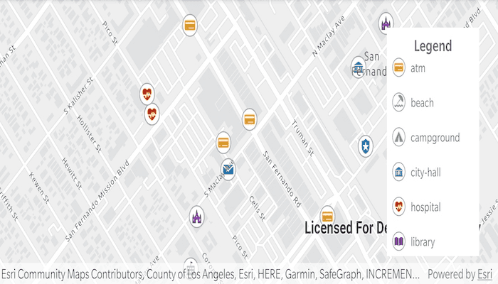
The sample displays a map with a set of symbols that represent the categories of the features within the dataset. Pan and zoom on the map and view the legend to explore the appearance and names of the different symbols from the selected symbol style.
How it works
- Create a
FeatureLayerand add it to the map. - Create a
UniqueValueRendererand set it to the feature layer. - Create a
SymbolStylefrom a portal by passing in the web style name and portal URL. * Note: passingnullas the portal will default to ArcGIS.com. - Search for symbols in the symbol style by name using
symbolStyle.getSymbolAsync(symbolName). - Create a
Symbolfrom the search result. - Create
UniqueValueobjects for each symbol with defined values to map the symbol to features on the feature layer. - Add each
UniqueValueto theUniqueValueRenderer.
Relevant API
- FeatureLayer
- Symbol
- SymbolStyle
- UniqueValue
- UniqueValueRenderer
About the data
The sample uses the 'Esri2DPointSymbolsStyle' Web Style.
The map shows features from the LA County Points of Interest service hosted on ArcGIS Online.
Additional information
2D web styles, dictionary web styles, and 3D web styles can all be hosted on an ArcGIS Online or Enterprise portal.
Tags
renderer, symbol, symbology, web style
Sample Code
package com.esri.arcgisruntime.sample.createsymbolstylesfromwebstyles
import android.graphics.Color
import android.os.Bundle
import android.util.Log
import android.view.MotionEvent
import android.view.View
import android.widget.LinearLayout
import android.widget.Toast
import androidx.appcompat.app.AppCompatActivity
import androidx.coordinatorlayout.widget.CoordinatorLayout
import com.esri.arcgisruntime.ArcGISRuntimeEnvironment
import com.esri.arcgisruntime.data.ServiceFeatureTable
import com.esri.arcgisruntime.layers.FeatureLayer
import com.esri.arcgisruntime.mapping.ArcGISMap
import com.esri.arcgisruntime.mapping.BasemapStyle
import com.esri.arcgisruntime.mapping.Viewpoint
import com.esri.arcgisruntime.mapping.view.DefaultMapViewOnTouchListener
import com.esri.arcgisruntime.mapping.view.MapView
import com.esri.arcgisruntime.sample.createsymbolstylesfromwebstyles.databinding.ActivityMainBinding
import com.esri.arcgisruntime.sample.createsymbolstylesfromwebstyles.databinding.LegendRowBinding
import com.esri.arcgisruntime.symbology.SymbolStyle
import com.esri.arcgisruntime.symbology.UniqueValueRenderer
import com.google.android.material.floatingactionbutton.FloatingActionButton
class MainActivity : AppCompatActivity() {
private val TAG = this::class.java.simpleName
private val activityMainBinding by lazy {
ActivityMainBinding.inflate(layoutInflater)
}
private val mapView: MapView by lazy {
activityMainBinding.mapView
}
private val legendFAB: FloatingActionButton by lazy {
activityMainBinding.legendFAB
}
private val scrollViewLayout: LinearLayout by lazy {
activityMainBinding.scrollViewLayout
}
override fun onCreate(savedInstanceState: Bundle?) {
super.onCreate(savedInstanceState)
setContentView(activityMainBinding.root)
// authentication with an API key or named user is required to access basemaps and other
// location services
ArcGISRuntimeEnvironment.setApiKey(BuildConfig.API_KEY)
// create a unique value renderer
val uniqueValueRenderer = UniqueValueRenderer().apply {
// add the name of a field from the feature layer data that symbols will be mapped to
fieldNames.add("cat2")
}
// create a feature layer from a service
val featureLayer =
FeatureLayer(ServiceFeatureTable("http://services.arcgis.com/V6ZHFr6zdgNZuVG0/arcgis/rest/services/LA_County_Points_of_Interest/FeatureServer/0")).apply {
// set the unique value renderer on the feature layer
renderer = uniqueValueRenderer
}
// create a map with the light gray basemap style
val map = ArcGISMap(BasemapStyle.ARCGIS_LIGHT_GRAY).apply {
// set an initial reference scale on the map for controlling symbol size
referenceScale = 100000.0
// add the feature layer to the map's operational layers
operationalLayers.add(featureLayer)
}
// set up map view properties
mapView.apply {
// set the map
this.map = map
// set a viewpoint
mapView.setViewpoint(Viewpoint(34.28301, -118.44186, 7000.0))
}
// create a symbol style from a web style
// note: ArcGIS Online is used as the default portal when null is passed as the portal parameter
val symbolStyle = SymbolStyle("Esri2DPointSymbolsStyle", null)
// setup the UI for the legend
setupUI()
// create a list of the required symbol names from the web style
val symbolNames = listOf(
"atm",
"beach",
"campground",
"city-hall",
"hospital",
"library",
"park",
"place-of-worship",
"police-station",
"post-office",
"school",
"trail"
)
// create unique values for the renderer and construct a symbol for each feature
symbolNames.forEach { symbolName ->
// create a placeholder legend row
val loadingLegendRowBinding = LegendRowBinding.inflate(layoutInflater).apply {
symbolTextView.text = getString(R.string.loading)
}
// add the placeholder row to the scroll view
scrollViewLayout.addView(loadingLegendRowBinding.root)
// search for each symbol in the symbol style
val searchResult = symbolStyle.getSymbolAsync(listOf(symbolName))
searchResult.addDoneListener {
try {
// get the symbol from the search result
val symbol = searchResult.get()
// get a list of all categories to be mapped to the symbol
val categories = mapSymbolNameToField(symbolName)
categories.forEach { category ->
// create a unique value for each category
val uniqueValue = UniqueValueRenderer.UniqueValue(
"",
symbolName,
symbol,
listOf(category)
)
// add each unique value to the unique value renderer
uniqueValueRenderer.uniqueValues.add(uniqueValue)
}
// create a swatch from symbol
val symbolBitmapFuture = symbol.createSwatchAsync(this, Color.WHITE)
symbolBitmapFuture.addDoneListener {
// create a legend row
val legendRowBinding = LegendRowBinding.inflate(layoutInflater).apply {
// set the symbol to the row's image view
symbolImageView.setImageBitmap(symbolBitmapFuture.get())
// set the symbol name to the row's text view
symbolTextView.text = symbolName
}
// remove the loading row already at this index
scrollViewLayout.removeViewAt(symbolNames.indexOf(symbolName))
// add the legend row at the correct index
scrollViewLayout.addView(
legendRowBinding.root,
symbolNames.indexOf(symbolName)
)
}
} catch (e: Exception) {
val error = "Error getting symbol: " + e.message
Toast.makeText(this, error, Toast.LENGTH_LONG).show()
Log.e(TAG, error)
}
}
}
// add a map scale changed listener on the map view to control the symbol sizes at different scales
mapView.addMapScaleChangedListener {
featureLayer.isScaleSymbols = mapView.mapScale >= 80000
}
}
/**
* Returns a list of categories to be matched to a symbol name.
*
* @param symbolName the name of a symbol from a symbol style
* @return categories a list of categories matched to the provided symbol name
*/
private fun mapSymbolNameToField(symbolName: String): List<String> {
return mutableListOf<String>().apply {
when (symbolName) {
"atm" -> add("Banking and Finance")
"beach" -> add("Beaches and Marinas")
"campground" -> add("Campgrounds")
"city-hall" -> addAll(
listOf(
"City Halls",
"Government Offices"
)
)
"hospital" -> addAll(
listOf(
"Hospitals and Medical Centers",
"Health Screening and Testing",
"Health Centers",
"Mental Health Centers"
)
)
"library" -> add("Libraries")
"park" -> add("Parks and Gardens")
"place-of-worship" -> add("Churches")
"police-station" -> add("Sheriff and Police Stations")
"post-office" -> addAll(
listOf(
"DHL Locations",
"Federal Express Locations"
)
)
"school" -> addAll(
listOf(
"Public High Schools",
"Public Elementary Schools",
"Private and Charter Schools"
)
)
"trail" -> add("Trails")
}
}
}
/**
* Sets up UI behaviour. Closes expandable floating action button on touching the scene view.
* Moves floating action button on attribution view expanded. Expands floating action button on
* tap.
*/
private fun setupUI() {
mapView.apply {
// create a touch listener
onTouchListener = object : DefaultMapViewOnTouchListener(applicationContext, mapView) {
// close the options sheet when the map is tapped
override fun onTouch(view: View?, motionEvent: MotionEvent?): Boolean {
if (legendFAB.isExpanded) {
legendFAB.isExpanded = false
}
return super.onTouch(view, motionEvent)
}
}
// ensure the floating action button moves to be above the attribution view
addAttributionViewLayoutChangeListener { _, _, _, _, bottom, _, _, _, oldBottom ->
val heightDelta = bottom - oldBottom
(legendFAB.layoutParams as CoordinatorLayout.LayoutParams).bottomMargin += heightDelta
}
}
// show the options sheet when the floating action button is clicked
legendFAB.setOnClickListener {
legendFAB.isExpanded = !legendFAB.isExpanded
}
}
override fun onPause() {
mapView.pause()
super.onPause()
}
override fun onResume() {
super.onResume()
mapView.resume()
}
override fun onDestroy() {
mapView.dispose()
super.onDestroy()
}
}