Show a callout with the latitude and longitude of user-tapped points.
Use case
Callouts are used to display temporary detail content on a map. You can display text and arbitrary UI controls in callouts.
How to use the sample
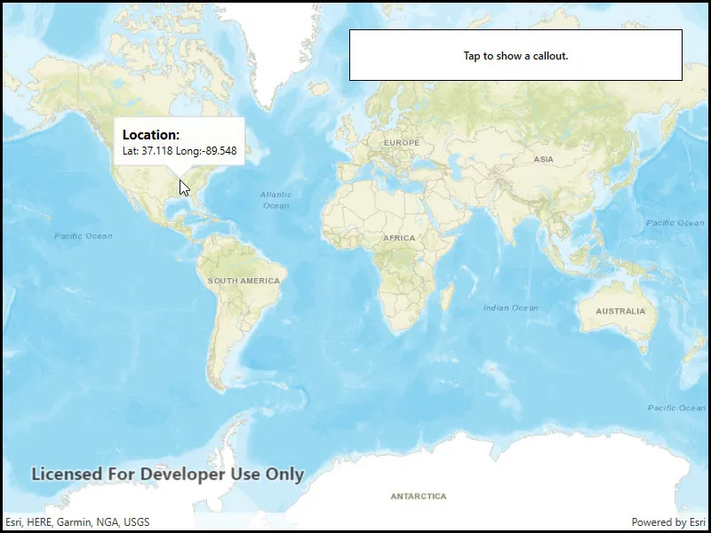
Tap anywhere on the map. A callout showing the WGS84 coordinates for the tapped point will appear.
How it works
- Listen for
GeoViewTappedevents on the map view. - When the user taps, get the tapped location from the
Locationproperty of theGeoViewInputEventArgs. - Project the geometry to WGS84 using
GeometryEngine.Project. - Create a string to display the coordinates; note that latitude and longitude in WGS84 map to the Y and X coordinates.
- Create a new callout definition using a title and the coordinate string.
- Display the callout by calling
ShowCalloutAton the map view with the location and the callout definition.
Relevant API
- CalloutDefinition
- GeometryEngine.Project
- GeoViewTappedEventArgs
- MapView.GeoViewTapped
- MapView.ShowCalloutAt
Tags
balloon, bubble, callout, flyout, flyover, info window, popup, tap
Sample code
// Copyright 2017 Esri.//// Licensed under the Apache License, Version 2.0 (the "License"); you may not use this file except in compliance with the License.// You may obtain a copy of the License at: http://www.apache.org/licenses/LICENSE-2.0//// Unless required by applicable law or agreed to in writing, software distributed under the License is distributed on an// "AS IS" BASIS, WITHOUT WARRANTIES OR CONDITIONS OF ANY KIND, either express or implied. See the License for the specific// language governing permissions and limitations under the License.
using Esri.ArcGISRuntime.Geometry;using Esri.ArcGISRuntime.Mapping;using Esri.ArcGISRuntime.UI;using Esri.ArcGISRuntime.UI.Controls;
namespace ArcGIS.WPF.Samples.ShowCallout{    [ArcGIS.Samples.Shared.Attributes.Sample(        name: "Show callout",        category: "MapView",        description: "Show a callout with the latitude and longitude of user-tapped points.",        instructions: "Tap anywhere on the map. A callout showing the WGS84 coordinates for the tapped point will appear.",        tags: new[] { "balloon", "bubble", "callout", "flyout", "flyover", "info window", "popup", "tap" })]    public partial class ShowCallout    {        public ShowCallout()        {            InitializeComponent();
            Initialize();        }
        private void Initialize()        {            // Create a new basemap using the streets base layer            Basemap myBasemap = new Basemap(BasemapStyle.ArcGISStreets);
            // Create a new map based on the streets basemap            Map myMap = new Map(myBasemap);
            // Assign the map to the MapView            MyMapView.Map = myMap;
            // Wire up the MapView GeoVewTapped event            MyMapView.GeoViewTapped += MyMapView_GeoViewTapped;        }
        private void MyMapView_GeoViewTapped(object sender, GeoViewInputEventArgs e)        {            // Get the user-tapped location            MapPoint mapLocation = e.Location;
            // Project the user-tapped map point location to a geometry            Geometry myGeometry = mapLocation.Project(SpatialReferences.Wgs84);
            // Convert to geometry to a traditional Lat/Long map point            MapPoint projectedLocation = (MapPoint)myGeometry;
            // Format the display callout string based upon the projected map point (example: "Lat: 100.123, Long: 100.234")            string mapLocationDescription = string.Format("Lat: {0:F3} Long:{1:F3}", projectedLocation.Y, projectedLocation.X);
            // Create a new callout definition using the formatted string            CalloutDefinition myCalloutDefinition = new CalloutDefinition("Location:", mapLocationDescription);
// Display the callout MyMapView.ShowCalloutAt(mapLocation, myCalloutDefinition); } }}<UserControl x:Class="ArcGIS.WPF.Samples.ShowCallout.ShowCallout" xmlns="http://schemas.microsoft.com/winfx/2006/xaml/presentation" xmlns:x="http://schemas.microsoft.com/winfx/2006/xaml" xmlns:esri="http://schemas.esri.com/arcgis/runtime/2013"> <Grid> <esri:MapView x:Name="MyMapView" /> <Border Style="{StaticResource BorderStyle}"> <TextBlock FontWeight="SemiBold" Text="Tap to show a callout." TextAlignment="Center" /> </Border> </Grid></UserControl>