Use a routing service to navigate between points.
Use case
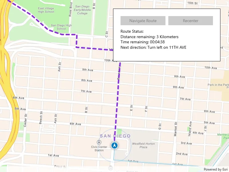
Navigation is often used by field workers while traveling between points to get live directions based on their location.
How to use the sample
Click ‘Navigate’ to simulate traveling and to receive directions from a preset starting point to a preset destination. Click ‘Recenter’ to refocus on the location display.
How it works
- Create a
RouteTaskusing a URL to an online route service. - Generate default
RouteParametersusingRouteTask.CreateDefaultParametersAsync(). - Set
ReturnStopsandReturnDirectionson the parameters to true. - Add
Stops to the parameters for each destination usingSetStops(stops). - Solve the route using
RouteTask.SolveRouteAsync(routeParameters)to get aRouteResult. - Create a
RouteTrackerusing the route result, and the index of the desired route to take. - Create a
RouteTrackerLocationDataSourcewith the route tracker and simulated location data source to snap the location display to the route. - Add a listener to capture
TrackingStatusChangedEvents, and then get theTrackingStatusand use it to display updated route information. Tracking status includes a variety of information on the route progress, such as the remaining distance, remaining geometry or traversed geometry (represented by aPolyline), or the remaining time (TimeSpan), amongst others. - Add a
NewVoiceGuidanceListenerto get theVoiceGuidancewhenever new instructions are available. From the voice guidance, get thestringrepresenting the directions and use a text-to-speech engine to output the maneuver directions. - You can also query the tracking status for the current
DirectionManeuverindex, retrieve that maneuver from theRouteand get it’s direction text to display in the GUI. - To establish whether the destination has been reached, get the
DestinationStatusfrom the tracking status. If the destination status isReached, we have arrived at the destination and can stop routing. If there are several destinations in your route, and the remaining destination count is greater than 1, switch the route tracker to the next destination.
Relevant API
- DestinationStatus
- DirectionManeuver
- Location
- LocationDataSource
- ReroutingStrategy
- Route
- RouteParameters
- RouteTask
- RouteTracker
- Stop
- VoiceGuidance
About the data
The route taken in this sample goes from the San Diego Convention Center, site of the annual Esri User Conference, to the Fleet Science Center, San Diego.
Tags
directions, maneuver, navigation, route, turn-by-turn, voice
Sample code
// Copyright 2019 Esri.//// Licensed under the Apache License, Version 2.0 (the "License"); you may not use this file except in compliance with the License.// You may obtain a copy of the License at: http://www.apache.org/licenses/LICENSE-2.0//// Unless required by applicable law or agreed to in writing, software distributed under the License is distributed on an// "AS IS" BASIS, WITHOUT WARRANTIES OR CONDITIONS OF ANY KIND, either express or implied. See the License for the specific// language governing permissions and limitations under the License.
using Esri.ArcGISRuntime.Geometry;using Esri.ArcGISRuntime.Location;using Esri.ArcGISRuntime.Mapping;using Esri.ArcGISRuntime.Navigation;using Esri.ArcGISRuntime.Symbology;using Esri.ArcGISRuntime.Tasks.NetworkAnalysis;using Esri.ArcGISRuntime.UI;using Microsoft.UI.Xaml;using System;using System.Collections.Generic;using System.Drawing;using System.Threading.Tasks;using Windows.Media.Core;using Windows.Media.Playback;using Windows.Media.SpeechSynthesis;
namespace ArcGIS.WinUI.Samples.NavigateRoute{    [ArcGIS.Samples.Shared.Attributes.Sample(        name: "Navigate route",        category: "Network analysis",        description: "Use a routing service to navigate between points.",        instructions: "Click 'Navigate' to simulate traveling and to receive directions from a preset starting point to a preset destination. Click 'Recenter' to refocus on the location display.",        tags: new[] { "directions", "maneuver", "navigation", "route", "turn-by-turn", "voice" })]    [ArcGIS.Samples.Shared.Attributes.OfflineData()]    public partial class NavigateRoute    {        // Variables for tracking the navigation route.        private RouteTracker _tracker;        private RouteResult _routeResult;        private Route _route;
        // List of driving directions for the route.        private IReadOnlyList<DirectionManeuver> _directionsList;
        // Speech synthesizer to play voice guidance audio.        private SpeechSynthesizer _speechSynthesizer = new SpeechSynthesizer();        private MediaPlayer _mediaPlayer = new MediaPlayer();
        // Graphics to show progress along the route.        private Graphic _routeAheadGraphic;        private Graphic _routeTraveledGraphic;
        // San Diego Convention Center.        private readonly MapPoint _conventionCenter = new MapPoint(-117.160386727, 32.706608, SpatialReferences.Wgs84);
        // USS San Diego Memorial.        private readonly MapPoint _memorial = new MapPoint(-117.173034, 32.712327, SpatialReferences.Wgs84);
        // RH Fleet Aerospace Museum.        private readonly MapPoint _aerospaceMuseum = new MapPoint(-117.147230, 32.730467, SpatialReferences.Wgs84);
        // Feature service for routing in San Diego.        private readonly Uri _routingUri = new Uri("https://sampleserver7.arcgisonline.com/server/rest/services/NetworkAnalysis/SanDiego/NAServer/Route");
        public NavigateRoute()        {            InitializeComponent();            _ = Initialize();        }
        private async Task Initialize()        {            try            {                // Add event handlers for when this sample is loaded/unloaded.                Loaded += SampleLoaded;                Unloaded += SampleUnloaded;
                // Create the map view.                MyMapView.Map = new Map(BasemapStyle.ArcGISNavigation);
                // Create the route task, using the online routing service.                RouteTask routeTask = await RouteTask.CreateAsync(_routingUri);
                // Get the default route parameters.                RouteParameters routeParams = await routeTask.CreateDefaultParametersAsync();
                // Explicitly set values for parameters.                routeParams.ReturnDirections = true;                routeParams.ReturnStops = true;                routeParams.ReturnRoutes = true;                routeParams.OutputSpatialReference = SpatialReferences.Wgs84;
                // Create stops for each location.                Stop stop1 = new Stop(_conventionCenter) { Name = "San Diego Convention Center" };                Stop stop2 = new Stop(_memorial) { Name = "USS San Diego Memorial" };                Stop stop3 = new Stop(_aerospaceMuseum) { Name = "RH Fleet Aerospace Museum" };
                // Assign the stops to the route parameters.                List<Stop> stopPoints = new List<Stop> { stop1, stop2, stop3 };                routeParams.SetStops(stopPoints);
                // Get the route results.                _routeResult = await routeTask.SolveRouteAsync(routeParams);                _route = _routeResult.Routes[0];
                // Add a graphics overlay for the route graphics.                MyMapView.GraphicsOverlays.Add(new GraphicsOverlay());
                // Add graphics for the stops.                SimpleMarkerSymbol stopSymbol = new SimpleMarkerSymbol(SimpleMarkerSymbolStyle.Diamond, Color.OrangeRed, 20);                MyMapView.GraphicsOverlays[0].Graphics.Add(new Graphic(_conventionCenter, stopSymbol));                MyMapView.GraphicsOverlays[0].Graphics.Add(new Graphic(_memorial, stopSymbol));                MyMapView.GraphicsOverlays[0].Graphics.Add(new Graphic(_aerospaceMuseum, stopSymbol));
                // Create a graphic (with a dashed line symbol) to represent the route.                _routeAheadGraphic = new Graphic(_route.RouteGeometry) { Symbol = new SimpleLineSymbol(SimpleLineSymbolStyle.Dash, Color.BlueViolet, 5) };
                // Create a graphic (solid) to represent the route that's been traveled (initially empty).                _routeTraveledGraphic = new Graphic { Symbol = new SimpleLineSymbol(SimpleLineSymbolStyle.Solid, Color.LightBlue, 3) };
                // Add the route graphics to the map view.                MyMapView.GraphicsOverlays[0].Graphics.Add(_routeAheadGraphic);                MyMapView.GraphicsOverlays[0].Graphics.Add(_routeTraveledGraphic);
                // Set the map viewpoint to show the entire route.                await MyMapView.SetViewpointGeometryAsync(_route.RouteGeometry, 100);
                // Enable the navigation button.                StartNavigationButton.IsEnabled = true;            }            catch (Exception e)            {                await new MessageDialog2(e.Message, "Error").ShowAsync();            }        }
        private void StartNavigation(object sender, RoutedEventArgs e)        {            // Disable the start navigation button.            StartNavigationButton.IsEnabled = false;
            // Get the directions for the route.            _directionsList = _route.DirectionManeuvers;
            // Create a route tracker.            _tracker = new RouteTracker(_routeResult, 0, true);            _tracker.NewVoiceGuidance += SpeakDirection;
            // Handle route tracking status changes.            _tracker.TrackingStatusChanged += TrackingStatusUpdated;
            // Turn on navigation mode for the map view.            MyMapView.LocationDisplay.AutoPanMode = LocationDisplayAutoPanMode.Navigation;            MyMapView.LocationDisplay.AutoPanModeChanged += AutoPanModeChanged;
            // Add a data source for the location display.            var simulationParameters = new SimulationParameters(DateTimeOffset.Now, 40.0);            var simulatedDataSource = new SimulatedLocationDataSource();            simulatedDataSource.SetLocationsWithPolyline(_route.RouteGeometry, simulationParameters);
            // Set the location display. Using RouteTrackerLocationDataSource ensures the display will snap to the route.            MyMapView.LocationDisplay.DataSource = new RouteTrackerLocationDataSource(_tracker, simulatedDataSource);
            // Use this instead if you want real location:            // MyMapView.LocationDisplay.DataSource = new RouteTrackerLocationDataSource(_tracker, new SystemLocationDataSource());
            // Enable the location display (this wil start the location data source).            MyMapView.LocationDisplay.IsEnabled = true;        }
        private async void TrackingStatusUpdated(object sender, RouteTrackerTrackingStatusChangedEventArgs e)        {            TrackingStatus status = e.TrackingStatus;
            // Start building a status message for the UI.            System.Text.StringBuilder statusMessageBuilder = new System.Text.StringBuilder("Route Status:\n");
            // Check the destination status.            if (status.DestinationStatus == DestinationStatus.NotReached || status.DestinationStatus == DestinationStatus.Approaching)            {                statusMessageBuilder.AppendLine("Distance remaining: " +                                            status.RouteProgress.RemainingDistance.DisplayText + " " +                                            status.RouteProgress.RemainingDistance.DisplayTextUnits.PluralDisplayName);
                statusMessageBuilder.AppendLine("Time remaining: " +                                                status.RouteProgress.RemainingTime.ToString(@"hh\:mm\:ss"));
                if (status.CurrentManeuverIndex + 1 < _directionsList.Count)                {                    statusMessageBuilder.AppendLine("Next direction: " + _directionsList[status.CurrentManeuverIndex + 1].DirectionText);                }
                // Set geometries for progress and the remaining route.                _routeAheadGraphic.Geometry = status.RouteProgress.RemainingGeometry;                _routeTraveledGraphic.Geometry = status.RouteProgress.TraversedGeometry;            }            else if (status.DestinationStatus == DestinationStatus.Reached)            {                statusMessageBuilder.AppendLine("Destination reached.");
                // Set the route geometries to reflect the completed route.                _routeAheadGraphic.Geometry = null;                _routeTraveledGraphic.Geometry = status.RouteResult.Routes[0].RouteGeometry;
                // Navigate to the next stop (if there are stops remaining).                if (status.RemainingDestinationCount > 1)                {                    await _tracker.SwitchToNextDestinationAsync();                }                else                {                    DispatcherQueue.TryEnqueue(Microsoft.UI.Dispatching.DispatcherQueuePriority.Normal, () =>                    {                        // Stop the simulated location data source.                        MyMapView.LocationDisplay.DataSource.StopAsync();                    });                }            }
            DispatcherQueue.TryEnqueue(Microsoft.UI.Dispatching.DispatcherQueuePriority.Normal, () =>            {                // Show the status information in the UI.                MessagesTextBlock.Text = statusMessageBuilder.ToString();            });        }
        private async void SpeakDirection(object sender, RouteTrackerNewVoiceGuidanceEventArgs e)        {            // Say the direction using voice synthesis.            if (e.VoiceGuidance.Text?.Length > 0)            {                _mediaPlayer.Pause();                var stream = await _speechSynthesizer.SynthesizeTextToStreamAsync(e.VoiceGuidance.Text);                _mediaPlayer.Source = MediaSource.CreateFromStream(stream, stream.ContentType);                _mediaPlayer.Play();            }        }
        private void AutoPanModeChanged(object sender, LocationDisplayAutoPanMode e)        {            // Turn the recenter button on or off when the location display changes to or from navigation mode.            RecenterButton.IsEnabled = e != LocationDisplayAutoPanMode.Navigation;        }
        private void RecenterButton_Click(object sender, RoutedEventArgs e)        {            // Change the mapview to use navigation mode.            MyMapView.LocationDisplay.AutoPanMode = LocationDisplayAutoPanMode.Navigation;        }
        private void SampleLoaded(object sender, RoutedEventArgs e)        {            // Re-attach tracker event handlers.            if (_tracker != null)            {                _tracker.NewVoiceGuidance += SpeakDirection;                _tracker.TrackingStatusChanged += TrackingStatusUpdated;            }
            // Restart the location data source.            _ = MyMapView.LocationDisplay?.DataSource?.StartAsync();        }
        private void SampleUnloaded(object sender, RoutedEventArgs e)        {            // Detach tracker event handlers.            if (_tracker != null)            {                _tracker.NewVoiceGuidance -= SpeakDirection;                _tracker.TrackingStatusChanged -= TrackingStatusUpdated;            }
// Stop the location data source. _ = MyMapView.LocationDisplay?.DataSource?.StopAsync(); } }}<UserControl x:Class="ArcGIS.WinUI.Samples.NavigateRoute.NavigateRoute" xmlns="http://schemas.microsoft.com/winfx/2006/xaml/presentation" xmlns:x="http://schemas.microsoft.com/winfx/2006/xaml" xmlns:esriUI="using:Esri.ArcGISRuntime.UI.Controls"> <Grid> <esriUI:MapView x:Name="MyMapView" /> <Border Style="{StaticResource BorderStyle}"> <Grid> <Grid.RowDefinitions> <RowDefinition /> <RowDefinition Height="100" /> </Grid.RowDefinitions> <Grid> <Grid.ColumnDefinitions> <ColumnDefinition /> <ColumnDefinition /> </Grid.ColumnDefinitions> <Button x:Name="StartNavigationButton" Grid.Column="0" Margin="5" HorizontalAlignment="Stretch" VerticalAlignment="Center" Click="StartNavigation" Content="Navigate route" IsEnabled="False" /> <Button x:Name="RecenterButton" Grid.Column="1" Margin="5" HorizontalAlignment="Stretch" VerticalAlignment="Center" Click="RecenterButton_Click" Content="Recenter" IsEnabled="False" /> </Grid> <TextBlock x:Name="MessagesTextBlock" Grid.Row="3" Margin="5" HorizontalAlignment="Stretch" VerticalAlignment="Stretch" TextWrapping="Wrap" /> </Grid> </Border> </Grid></UserControl>