Introduction
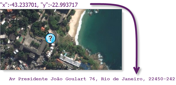
The reverse_geocode() function in the arcgis.geocoding module determines the address at a particular x/y location. You can pass the coordinates of a point location to the geocoder and get returned the address that is closest (or nearest) to the location.
from arcgis.geocoding import reverse_geocode

help(reverse_geocode)
Help on function reverse_geocode in module arcgis.geocoding._functions:
reverse_geocode(location: 'Union[list, dict, Point]', distance: 'Optional[float]' = None, out_sr: 'Optional[Union[int, SpatialReference]]' = None, lang_code: 'Optional[str]' = None, return_intersection: 'bool' = False, for_storage: 'bool' = False, geocoder: 'Optional[Geocoder]' = None, feature_types: 'Optional[str]' = None, location_top: 'str' = 'street')
The ``reverse_geocode`` operation determines the address at a particular
x/y location. You pass the coordinates of a point location to the
geocoding service, and the service returns the address that is
closest to the location.
=================== ====================================================
**Parameter** **Description**
------------------- ----------------------------------------------------
location Required location input as list, dict (with or without SpatialReference),
or :class:`~arcgis.geometry.Point` object.
------------------- ----------------------------------------------------
distance optional float, radial distance in meters to
search for an address.
.. note::
The default for ``distance`` is 100 meters.
------------------- ----------------------------------------------------
out_sr optional integer or
:class:`~arcgis.geometry.SpatialReference` of the
x/y coordinate returned.
------------------- ----------------------------------------------------
lang_code optional string. Sets the language in which geocode
results are returned. This is useful for ensuring
that results are returned in the expected language.
If the lang_code parameter isn't included in a
request, or if it is included but there are no
matching features with the input language code, the
resultant match is returned in the language code of
the primary matched components from the input search
string.
------------------- ----------------------------------------------------
return_intersection optional Boolean, which specifies whether the
service should return the nearest street
intersection or the nearest address to the input
location
------------------- ----------------------------------------------------
for_storage optional boolean, specifies whether the results of
the operation will be persisted
------------------- ----------------------------------------------------
geocoder optional :class:`~arcgis.geocoding.Geocoder`,
the geocoder to be used.
.. note::
If not specified, the active ``GIS`` instances
first ``Geocoder`` is used.
------------------- ----------------------------------------------------
feature_types Optional String. Limits the possible match types
performed by the `reverse_geocode` method. If a
single value is included, the search tolerance for
the input feature type is 500 meters. If multiple
values (separated by a comma, with no spaces) are
included, the default search distances specified in
the feature type hierarchy table are applied.
Values: `StreetInt, DistanceMarker, StreetAddress,
StreetName, POI, PointAddress, Postal, and
Locality`
------------------- ----------------------------------------------------
location_type Optional string. Specifies whether the rooftop point
or street entrance is used as the output geometry of
point address matches. By default,
``street`` is used,
which is useful in routing scenarios, as the rooftop
location of some addresses may be offset from a
street by a large distance. However, for map display
purposes, you may want to use ``rooftop`` instead,
especially when large buildings or landmarks are
geocoded. The ``location_type`` parameter only
affects the location object in the JSON response
and does not change the x,y or
``DisplayX/DisplayY`` attribute values.
Values: ``street``, ``rooftop``
=================== ====================================================
.. code-block:: python
# Usage Example
>>> reversed = Geocoder.reverse_geocode(location = point1,
distance = 50,
for_storage = True,
feature_types = "StreetName",
location_type = "street")
>>> type(reversed)
<Dictionary>
:return:
A dictionary
The required location parameter
As shown in the help output above, the only required input parameter of reverse_geocode() is the location parameter, which is the point from which to search for the closest address. The point can be represented as:
- a
listof coordinates in either [x, y] or [longitude, latitude] format - a
dictobject (with or without spatial reference) - a Point Geometry
The spatial reference of the list of coordinates is WGS84 (in decimal degress), the same coordinate system as the World Geocoding Service.
Use a Python dictionary to meet the JSON formatting (see Geometry objects for details) requirements of the service to specify any other coordinate system for the input location. Specifically, set the spatial reference using its well-known ID (WKID) value. For a list of valid WKID values, see the Using spatial references help page.
- Example using the default
WGS84spatial reference:
location=[103.8767227,1.3330736]
- Example using a dictionary and the default
WGS84spatial reference:
location={"x": 103.876722, "y": 1.3330736}
- Example using a dictionary and specifying a spatial reference (
WGS84 Web Mercator Auxiliary Sphere):
location= {
    "x": 11563503,
    "y": 148410,
    "spatialReference": {"wkid": 3857}
}
The simple reverse geocode examples
Next, we will look at different kinds of input for the location parameter - (1) list, (2) dict, (3) dict with sr, and (4) Point object. Note that, when composing a list containing x/y coordinates, the order is X,Y and not Y,X as in lat, long.
from arcgis.gis import GIS
from arcgis.geocoding import reverse_geocode

gis = GIS(profile="your_online_profile")
Example 1 - location input as list
results = reverse_geocode([2.2945, 48.8583])type(results)dict
results{'address': {'Match_addr': 'Le Jules Verne',
'LongLabel': 'Le Jules Verne, Avenue Gustave Eiffel, 75007, 7e Arrondissement, Paris, Île-de-France, FRA',
'ShortLabel': 'Le Jules Verne',
'Addr_type': 'POI',
'Type': 'French Food',
'PlaceName': 'Le Jules Verne',
'AddNum': '',
'Address': 'Avenue Gustave Eiffel',
'Block': '',
'Sector': '',
'Neighborhood': '',
'District': '7e Arrondissement',
'City': 'Paris',
'MetroArea': '',
'Subregion': 'Paris',
'Region': 'Île-de-France',
'RegionAbbr': 'IDF',
'Territory': '',
'Postal': '75007',
'PostalExt': '',
'CntryName': 'France',
'CountryCode': 'FRA',
'X': 2.29499002216,
'Y': 48.857664577355,
'InputX': 2.2945,
'InputY': 48.8583},
'location': {'x': 2.29499002216,
'y': 48.857664577355,
'spatialReference': {'wkid': 4326, 'latestWkid': 4326}}}Example 2 - location input as dict
results = reverse_geocode(location={"x": 103.876722, "y": 1.3330736})
results
{'address': {'Match_addr': 'Sennett Estate, 40 Lichi Avenue, 348814, Singapore',
'LongLabel': 'Sennett Estate, 40 Lichi Avenue, 348814, Singapore, SGP',
'ShortLabel': 'Sennett Estate, 40 Lichi Avenue',
'Addr_type': 'PointAddress',
'Type': '',
'PlaceName': '',
'AddNum': '40',
'Address': 'Sennett Estate, 40 Lichi Avenue',
'Block': '',
'Sector': '',
'Neighborhood': '',
'District': '',
'City': 'Singapore',
'MetroArea': '',
'Subregion': '',
'Region': 'Singapore',
'RegionAbbr': '',
'Territory': '',
'Postal': '348814',
'PostalExt': '',
'CntryName': 'Singapore',
'CountryCode': 'SGP',
'X': 103.876669734659,
'Y': 1.333215376983,
'InputX': 103.876722,
'InputY': 1.3330736},
'location': {'x': 103.876669734659,
'y': 1.333215376983,
'spatialReference': {'wkid': 4326, 'latestWkid': 4326}}}Example 3 - location input as dict with sr
results = reverse_geocode(
    location= {
        "x": 11563503,
        "y": 148410,
        "spatialReference": {"wkid": 3857}
    }
)
results
{'address': {'Match_addr': 'Sennett Estate, 40 Lichi Avenue, 348814, Singapore',
'LongLabel': 'Sennett Estate, 40 Lichi Avenue, 348814, Singapore, SGP',
'ShortLabel': 'Sennett Estate, 40 Lichi Avenue',
'Addr_type': 'PointAddress',
'Type': '',
'PlaceName': '',
'AddNum': '40',
'Address': 'Sennett Estate, 40 Lichi Avenue',
'Block': '',
'Sector': '',
'Neighborhood': '',
'District': '',
'City': 'Singapore',
'MetroArea': '',
'Subregion': '',
'Region': 'Singapore',
'RegionAbbr': '',
'Territory': '',
'Postal': '348814',
'PostalExt': '',
'CntryName': 'Singapore',
'CountryCode': 'SGP',
'X': 103.876669734659,
'Y': 1.333215376983,
'InputX': 103.876714828619,
'InputY': 1.333069425643},
'location': {'x': 103.876669734659,
'y': 1.333215376983,
'spatialReference': {'wkid': 4326, 'latestWkid': 4326}}}Example 4 - location input as Point Geometry object
from arcgis.geometry import Geometry

pt = Geometry({
    "x": 11563503,
    "y": 148410,
    "spatialReference": {
        "wkid": 3857
    }
})
results = reverse_geocode(pt)
type(results)dict
results{'address': {'Match_addr': 'Sennett Estate, 40 Lichi Avenue, 348814, Singapore',
'LongLabel': 'Sennett Estate, 40 Lichi Avenue, 348814, Singapore, SGP',
'ShortLabel': 'Sennett Estate, 40 Lichi Avenue',
'Addr_type': 'PointAddress',
'Type': '',
'PlaceName': '',
'AddNum': '40',
'Address': 'Sennett Estate, 40 Lichi Avenue',
'Block': '',
'Sector': '',
'Neighborhood': '',
'District': '',
'City': 'Singapore',
'MetroArea': '',
'Subregion': '',
'Region': 'Singapore',
'RegionAbbr': '',
'Territory': '',
'Postal': '348814',
'PostalExt': '',
'CntryName': 'Singapore',
'CountryCode': 'SGP',
'X': 103.876669734659,
'Y': 1.333215376983,
'InputX': 103.876714828619,
'InputY': 1.333069425643},
'location': {'x': 103.876669734659,
'y': 1.333215376983,
'spatialReference': {'wkid': 4326, 'latestWkid': 4326}}}Reverse geocode a location and show on the map
map1 = gis.map('Singapore')
map1
pt = Geometry({
    "x": 11563503,
    "y": 148410,
    "spatialReference": {
        "wkid": 3857
    }
})

results = reverse_geocode(pt)
map1.content.draw(
shape=Geometry(results["location"])
)Get result as intersection instead of address (return_intersection param)
Facts about the return_intersection parameter:
- A Boolean which specifies whether the service should return the nearest street intersection or the nearest address to the input location.
- If True, then the closest intersection to the input location is returned;
- if False, then the closest address to the input location is returned.
- The default value is False.
See the Ready-to-use Geocoding document for full details.
# Let's take a look at the intersection of W. Vine St & S 4th St in the city of Redlands, CA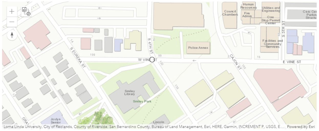
from arcgis.geocoding import geocode
intersect_loc = geocode("S 4th St & W Vine, Redlands, CA")[0]['location']
print(intersect_loc)
{'x': -117.18361987601203, 'y': 34.0546600260095}
When the return_intersection parameter is not specified, or set to False, then the closest address to the input location is returned. We can see below that the returned address is a StreetAddress, instead of intersection, and that the matched addresses are of Street number 130 to 134 on the S 4th St.
reverse_geocode(intersect_loc){'address': {'Match_addr': '130-134 S 4th St, Redlands, California, 92373',
'LongLabel': '130-134 S 4th St, Redlands, CA, 92373, USA',
'ShortLabel': '130-134 S 4th St',
'Addr_type': 'StreetAddress',
'Type': '',
'PlaceName': '',
'AddNum': '130',
'Address': '130 S 4th St',
'Block': '',
'Sector': '',
'Neighborhood': 'South Redlands',
'District': '',
'City': 'Redlands',
'MetroArea': 'Inland Empire',
'Subregion': 'San Bernardino County',
'Region': 'California',
'Territory': '',
'Postal': '92373',
'PostalExt': '',
'CountryCode': 'USA'},
'location': {'x': -117.18367019351942,
'y': 34.054620721017486,
'spatialReference': {'wkid': 4326, 'latestWkid': 4326}}}On the other hand, when set to True, then the closest intersection to the input location is returned. We can see this in the Match_addr and Addr_Type output fields shown below:
reverse_geocode(intersect_loc,
                return_intersection = True)
{'address': {'Match_addr': 'S 4th St & W Vine St, Redlands, California, 92373',
'LongLabel': 'S 4th St & W Vine St, Redlands, CA, 92373, USA',
'ShortLabel': 'S 4th St & W Vine St',
'Addr_type': 'StreetInt',
'Type': '',
'PlaceName': '',
'AddNum': '',
'Address': 'S 4th St & W Vine St',
'Block': '',
'Sector': '',
'Neighborhood': 'South Redlands',
'District': '',
'City': 'Redlands',
'MetroArea': 'Inland Empire',
'Subregion': 'San Bernardino County',
'Region': 'California',
'Territory': '',
'Postal': '92373',
'PostalExt': '',
'CountryCode': 'USA'},
'location': {'x': -117.18361987601203,
'y': 34.05466002600951,
'spatialReference': {'wkid': 4326, 'latestWkid': 4326}}}Get results in desired SR
Facts about the out_sr parameter:
- The spatial reference of the x/y coordinates returned by a geocode request. This is useful for applications using a map with a spatial reference different than that of the geocode service.
- The spatial reference can be specified as either a
well-known ID (WKID)or asa JSON spatial reference object. Ifout_sris not specified, the spatial reference of the output locations is the same as that of the service. The World Geocoding Service spatial reference isWGS84 (WKID = 4326).
Example (102100 is the WKID for the Web Mercator projection):
out_sr=102100
The first example below shows a version of Example 4, when our_sr is specified different than WGS84:
reverse_geocode(
    location = {
        'x': 103.87671885261159,
        'y': 1.333058719212687,
        'spatialReference': {'wkid': 4326, 'latestWkid': 4326}
    },
    out_sr = 3857
)
{'address': {'Match_addr': 'Sennett Estate, 40 Lichi Avenue, 348814, Singapore',
'LongLabel': 'Sennett Estate, 40 Lichi Avenue, 348814, Singapore, SGP',
'ShortLabel': 'Sennett Estate, 40 Lichi Avenue',
'Addr_type': 'PointAddress',
'Type': '',
'PlaceName': '',
'AddNum': '40',
'Address': 'Sennett Estate, 40 Lichi Avenue',
'Block': '',
'Sector': '',
'Neighborhood': '',
'District': '',
'City': 'Singapore',
'MetroArea': '',
'Subregion': '',
'Region': 'Singapore',
'Territory': '',
'Postal': '348814',
'PostalExt': '',
'CountryCode': 'SGP'},
'location': {'x': 11563503.447948763,
'y': 148408.80784300127,
'spatialReference': {'wkid': 102100, 'latestWkid': 3857}}}Get results in desired language (lang_code param)
Facts about the lang_code parameter:
- Sets the language in which reverse-geocoded addresses are returned. Addresses in many countries are available in more than one language. In these cases, the
lang_codeparameter can be used to specify which language should be used for addresses returned by thereverse_geocode()method. This is useful for ensuring that addresses are returned in the expected language by reverse geocoding functionality in an application. For example, a web application could be designed to get the browser language and then pass it as thelang_codeparameter value in areverse_geocoderequest. - See this table of supported countries for valid language code values in each country.
Now let's look at an example of reverse_geocode() using the land_code parameter applied to the starting point of the Great Wall of China, and the Taj Marble in India:
# returning Simplified Chinese
reverse_geocode(
    location = {'x': 119.79533000000004,
                'y': 39.96675000000005},
    lang_code = "ZH"
)
{'address': {'Match_addr': '河北省秦皇岛市山海关区',
'LongLabel': '河北省秦皇岛市山海关区',
'ShortLabel': '河北省秦皇岛市山海关区',
'CountryCode': 'CHN',
'City': '秦皇岛市',
'Neighborhood': '山海关区',
'Region': '河北省',
'Address': '河北省秦皇岛市山海关区',
'Addr_type': 'Locality',
'Type': '',
'PlaceName': '',
'AddNum': '',
'Block': '',
'Sector': '',
'District': '',
'MetroArea': '',
'Subregion': '',
'Territory': '',
'Postal': '',
'PostalExt': ''},
'location': {'x': 119.744545,
'y': 40.018464,
'spatialReference': {'wkid': 4326, 'latestWkid': 4326}}}# returns in Hindi
reverse_geocode({
'x': 74.81476000000004,
'y': 34.02453000000003
},
lang_code="HIN"){'address': {'Match_addr': 'एनएच-1ए, नातिपुरा, श्रीनगर, जम्मू और कश्मीर, 190015',
'LongLabel': 'एनएच-1ए, नातिपुरा, श्रीनगर, जम्मू और कश्मीर, 190015, IND',
'ShortLabel': 'एनएच-1ए',
'Addr_type': 'StreetName',
'Type': '',
'PlaceName': '',
'AddNum': '',
'Address': 'एनएच-1ए',
'Block': '',
'Sector': '',
'Neighborhood': '',
'District': 'नातिपुरा',
'City': 'श्रीनगर',
'MetroArea': '',
'Subregion': 'श्रीनगर',
'Region': 'जम्मू और कश्मीर',
'Territory': '',
'Postal': '190015',
'PostalExt': '',
'CountryCode': 'IND'},
'location': {'x': 74.81476450480069,
'y': 34.024511515995734,
'spatialReference': {'wkid': 4326, 'latestWkid': 4326}}}Customize the address type of searches (feature_types param)
The feature_types parameter:
- Limits the possible match types performed by the
reverse_geocodemethod. - If a single value is included, the search tolerance for the input feature type is
500meters. - If multiple values (separated by a comma, with no spaces) are included, the default search distances specified in the feature type hierarchy table are applied.
- The list below includes the valid values for the
feature_typesparameter:- StreetInt, DistanceMarker, StreetAddress, StreetName, POI, PointAddress, Postal, and Locality
See the reference documente here for more information.
Let's see an example of reverse geocoding for the Yosemite National Park (at Stanislaus) and how changing the feature_types from POI to StreetAddress, or other types in getting navigable address for GPS, will be different. Note that there will be different output of the X,Y coordinates in the returned dict:
map3 = gis.map("Stanislaus, CA")
map3.zoom = 19
map3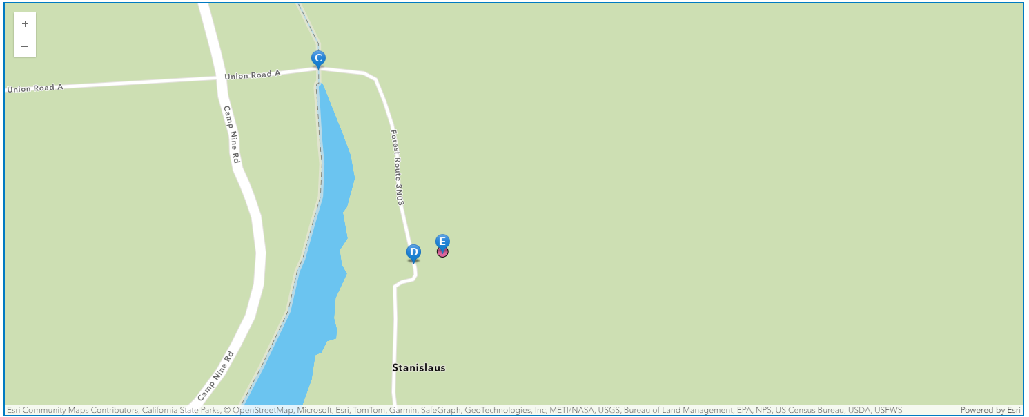
park_xy = Geometry({'x':-13399528.102591 , 'y':4599075.538836, 'spatialReference': {'wkid':102100}})
map3.content.draw(park_xy)
# without specifying the `feature_types`
from arcgis.map.symbols import PictureMarkerSymbolEsriPMS
park_a = reverse_geocode(park_xy)
map3.content.draw(
shape=park_a["location"],
symbol = PictureMarkerSymbolEsriPMS(**{"angle":0,
"xoffset":0,
"yoffset":8.15625,
"type":"esriPMS",
"url":"http://static.arcgis.com/images/Symbols/AtoZ/blueA.png",
"contentType":"image/png",
"width":15.75,
"height":21.75}
)
)
display(park_a){'address': {'Match_addr': 'Forest Route 3N03, MI Wuk Village, California, 95346',
'LongLabel': 'Forest Route 3N03, MI Wuk Village, CA, 95346, USA',
'ShortLabel': 'Forest Route 3N03',
'Addr_type': 'StreetName',
'Type': '',
'PlaceName': '',
'AddNum': '',
'Address': 'Forest Route 3N03',
'Block': '',
'Sector': '',
'Neighborhood': '',
'District': '',
'City': 'MI Wuk Village',
'MetroArea': '',
'Subregion': 'Tuolumne County',
'Region': 'California',
'RegionAbbr': 'CA',
'Territory': '',
'Postal': '95346',
'PostalExt': '',
'CntryName': 'United States',
'CountryCode': 'USA',
'X': -120.370234753138,
'Y': 38.138900996563,
'InputX': -120.370008945465,
'InputY': 38.138964926295},
'location': {'x': -120.370234753138,
'y': 38.138900996563,
'spatialReference': {'wkid': 4326, 'latestWkid': 4326},
'type': 'point'}}# search_tolerance = 10 meters
park_b = reverse_geocode(park_xy, feature_types = "StreetInt")
map3.content.draw(
shape=park_b["location"],
symbol = PictureMarkerSymbolEsriPMS(**{"angle":0,
"xoffset":0,
"yoffset":8.15625,
"type":"esriPMS",
"url":"http://static.arcgis.com/images/Symbols/AtoZ/blueC.png",
"contentType":"image/png",
"width":15.75,
"height":21.75}
)
)
display(park_b){'address': {'Match_addr': 'Forest Route 3N03 & Union Road A, MI Wuk Village, California, 95346',
'LongLabel': 'Forest Route 3N03 & Union Road A, MI Wuk Village, CA, 95346, USA',
'ShortLabel': 'Forest Route 3N03 & Union Road A',
'Addr_type': 'StreetInt',
'Type': '',
'PlaceName': '',
'AddNum': '',
'Address': 'Forest Route 3N03 & Union Road A',
'Block': '',
'Sector': '',
'Neighborhood': '',
'District': '',
'City': 'MI Wuk Village',
'MetroArea': '',
'Subregion': 'Tuolumne County',
'Region': 'California',
'RegionAbbr': 'CA',
'Territory': '',
'Postal': '95346',
'PostalExt': '',
'CntryName': 'United States',
'CountryCode': 'USA',
'X': -120.37097308802,
'Y': 38.140086302599,
'InputX': -120.370008945465,
'InputY': 38.138964926295},
'location': {'x': -120.37097308802,
'y': 38.140086302599,
'spatialReference': {'wkid': 4326, 'latestWkid': 4326},
'type': 'point'}}# search_tolerance = 3 meters
park_d = reverse_geocode(
location=park_xy,
feature_types = "StreetAddress,DistanceMarker,StreetName"
)
map3.content.draw(
shape=park_d["location"],
symbol = PictureMarkerSymbolEsriPMS(**{"angle":0,
"xoffset":0,
"yoffset":8.15625,
"type":"esriPMS",
"url":"http://static.arcgis.com/images/Symbols/AtoZ/blueD.png",
"contentType":"image/png",
"width":15.75,
"height":21.75}
)
)
display(park_d){'address': {'Match_addr': 'Forest Route 3N03, MI Wuk Village, California, 95346',
'LongLabel': 'Forest Route 3N03, MI Wuk Village, CA, 95346, USA',
'ShortLabel': 'Forest Route 3N03',
'Addr_type': 'StreetName',
'Type': '',
'PlaceName': '',
'AddNum': '',
'Address': 'Forest Route 3N03',
'Block': '',
'Sector': '',
'Neighborhood': '',
'District': '',
'City': 'MI Wuk Village',
'MetroArea': '',
'Subregion': 'Tuolumne County',
'Region': 'California',
'RegionAbbr': 'CA',
'Territory': '',
'Postal': '95346',
'PostalExt': '',
'CntryName': 'United States',
'CountryCode': 'USA',
'X': -120.370234753138,
'Y': 38.138900996563,
'InputX': -120.370008945465,
'InputY': 38.138964926295},
'location': {'x': -120.370234753138,
'y': 38.138900996563,
'spatialReference': {'wkid': 4326, 'latestWkid': 4326},
'type': 'point'}}# search_tolerance = within boundaries
# If the input location intersects multiple boundaries, the feature with the smallest area is returned.
park_e = reverse_geocode(
location=park_xy,
feature_types = "Locality,Postal"
)
map3.content.draw(
shape=park_e["location"],
symbol = PictureMarkerSymbolEsriPMS(**{"angle":0,
"xoffset":0,
"yoffset":8.15625,
"type":"esriPMS",
"url":"http://static.arcgis.com/images/Symbols/AtoZ/blueE.png",
"contentType":"image/png",
"width":15.75,"height":21.75}
)
)
display(park_e){'address': {'Match_addr': '95346, MI Wuk Village, California',
'LongLabel': '95346, MI Wuk Village, CA, USA',
'ShortLabel': '95346',
'Addr_type': 'Postal',
'Type': '',
'PlaceName': '95346',
'AddNum': '',
'Address': '',
'Block': '',
'Sector': '',
'Neighborhood': '',
'District': '',
'City': 'MI Wuk Village',
'MetroArea': '',
'Subregion': 'Tuolumne County',
'Region': 'California',
'RegionAbbr': 'CA',
'Territory': '',
'Postal': '95346',
'PostalExt': '',
'CntryName': 'United States',
'CountryCode': 'USA',
'X': -120.370008945465,
'Y': 38.138964926295,
'InputX': -120.370008945465,
'InputY': 38.138964926295},
'location': {'x': -120.370008945465,
'y': 38.138964926295,
'spatialReference': {'wkid': 4326, 'latestWkid': 4326},
'type': 'point'}}park_f = reverse_geocode(
locaton= {
'x':-13399528.102591 ,
'y':4599075.538836
},
feature_types = "POI area"
)
map3.content.draw(
shape=park_f["location"],
symbol = PictureMarkerSymbolEsriPMS(**{"angle":0,
"xoffset":0,
"yoffset":8.15625,
"type":"esriPMS",
"url":"http://static.arcgis.com/images/Symbols/AtoZ/blueF.png",
"contentType":"image/png",
"width":15.75,
"height":21.75}
)
)
display(park_f){'address': {'Match_addr': 'Ozero Shybyndy',
'LongLabel': 'Ozero Shybyndy',
'ShortLabel': 'Ozero Shybyndy',
'Addr_type': 'POI',
'Type': 'Lake',
'PlaceName': 'Ozero Shybyndy',
'AddNum': '',
'Address': '',
'Block': '',
'Sector': '',
'Neighborhood': '',
'District': '',
'City': '',
'MetroArea': '',
'Subregion': '',
'Region': '',
'RegionAbbr': '',
'Territory': '',
'Postal': '',
'PostalExt': '',
'CntryName': '',
'CountryCode': '',
'X': 0.0,
'Y': 90.0,
'InputX': -13399528.102591,
'InputY': 4599075.538836},
'location': {'x': 0.0,
'y': 90.0,
'spatialReference': {'wkid': 4326, 'latestWkid': 4326},
'type': 'point'}}As we can see from the map above, park_a, park_d, park_e and park_f all point to the same location (the centroid of Yosemite National Park), while park_b and park_c are slightly offset from the centroid.
Limit searches by distance param
Here, note that default distance varies by feature_types and more can be learnt from here
distance parameter
- The optional distance parameter allows you to specify a radial distance in meters to search for an address from the specified location. If no distance value is specified, then the value is assumed to be 100 meters.
Example:
distance=50
# search_tolerance = 10 meters
reverse_geocode(
    location={'x': -87.62330985,'y':41.88270585},
    feature_types = "POI",
    distance=10
)
{'address': {'Match_addr': 'The Bean',
'LongLabel': 'The Bean, Chicago, IL, 60603, USA',
'ShortLabel': 'The Bean',
'Addr_type': 'POI',
'Type': 'Tourist Attraction',
'PlaceName': 'The Bean',
'AddNum': '',
'Address': '',
'Block': '',
'Sector': '',
'Neighborhood': 'Loop',
'District': '',
'City': 'Chicago',
'MetroArea': 'Chicagoland',
'Subregion': 'Cook County',
'Region': 'Illinois',
'Territory': '',
'Postal': '60603',
'PostalExt': '',
'CountryCode': 'USA'},
'location': {'x': -87.62351981667449,
'y': 41.88258590496559,
'spatialReference': {'wkid': 4326, 'latestWkid': 4326}}}# search_tolerance = 500 meters
reverse_geocode(
location={'x': -87.62330995,'y':41.88270595},
distance=500
){'address': {'Match_addr': 'Park Cafe',
'LongLabel': 'Park Cafe, 11 N Michigan Ave, Chicago, IL, 60602, USA',
'ShortLabel': 'Park Cafe',
'Addr_type': 'POI',
'Type': 'Restaurant',
'PlaceName': 'Park Cafe',
'AddNum': '11',
'Address': '11 N Michigan Ave',
'Block': '',
'Sector': '',
'Neighborhood': '',
'District': '',
'City': 'Chicago',
'MetroArea': '',
'Subregion': 'Cook County',
'Region': 'Illinois',
'Territory': '',
'Postal': '60602',
'PostalExt': '',
'CountryCode': 'USA'},
'location': {'x': -87.62330499999996,
'y': 41.88267500000006,
'spatialReference': {'wkid': 4326, 'latestWkid': 4326}}}Conclusions
In Part 5 of the Series, we have explored how to perform reverse_geocode() with different input (e.g. JSON, List object, or Point Geometry object) and optional parameters to limit the search results. The optional parameters used included lang_code, distance, feature_types, etc. In the next notebook, we will discuss how to work with a customized geocoder.