Create simple geometry types.
Use case
Geometries are used to represent real world features as vector GIS data. Points are used to mark specific XY locations, such as landmarks and other points of interest. Polylines are made up of 2 or more XY vertices and can be used to mark roads, flight paths, or boundaries. Polygons are made up of 3 or more XY vertices and can be used to represent a lake, country, or a park. Geometries can be stored as features in a database, displayed as Graphics in a map, or used for performing spatial analysis with GeometryEngine or a GeoprocessingTask.
How to use the sample
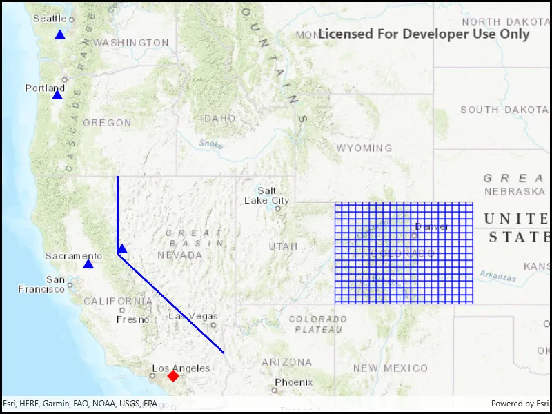
Pan and zoom freely to see the different types of geometries placed onto the map.
How it works
- Use the constructors for the various simple
Geometrytypes includingPoint,Polyline,Multipoint,Polygon, andEnvelope. - To display the geometry, create a
Graphicpassing in the geometry, and aSymbolappropriate for the geometry type. - Add the graphic to a graphics overlay and add the overlay to a map view.
Relevant API
- Envelope
- Multipoint
- Point
- PointCollection
- Polygon
- Polyline
Additional information
A geometry made of multiple points usually takes a PointCollection as an argument or is created through a builder.
Tags
area, boundary, line, marker, path, shape
Sample code
// Copyright 2018 Esri.//// Licensed under the Apache License, Version 2.0 (the "License"); you may not use this file except in compliance with the License.// You may obtain a copy of the License at: http://www.apache.org/licenses/LICENSE-2.0//// Unless required by applicable law or agreed to in writing, software distributed under the License is distributed on an// "AS IS" BASIS, WITHOUT WARRANTIES OR CONDITIONS OF ANY KIND, either express or implied. See the License for the specific// language governing permissions and limitations under the License.
using Esri.ArcGISRuntime.Geometry;using Esri.ArcGISRuntime.Mapping;using Esri.ArcGISRuntime.Symbology;using Esri.ArcGISRuntime.UI;
namespace ArcGIS.WinUI.Samples.CreateGeometries{    [ArcGIS.Samples.Shared.Attributes.Sample(        name: "Create geometries",        category: "Geometry",        description: "Create simple geometry types.",        instructions: "Pan and zoom freely to see the different types of geometries placed onto the map.",        tags: new[] { "area", "boundary", "line", "marker", "path", "shape" })]    public partial class CreateGeometries    {        public CreateGeometries()        {            InitializeComponent();
            Initialize();        }
        private void Initialize()        {            // Create a map with a topographic basemap.            Map theMap = new Map(BasemapStyle.ArcGISTopographic);
            // Assign the map to the MapView.            MyMapView.Map = theMap;
            // Create a simple fill symbol - used to render a polygon covering Colorado.            SimpleFillSymbol theSimpleFillSymbol = new SimpleFillSymbol(SimpleFillSymbolStyle.Cross, System.Drawing.Color.Blue, null);
            // Create a simple line symbol - used to render a polyline border between California and Nevada.            SimpleLineSymbol theSimpleLineSymbol = new SimpleLineSymbol(SimpleLineSymbolStyle.Solid, System.Drawing.Color.Blue, 3);
            // Create a simple marker symbol - used to render multi-points for various state capital locations in the Western United States.            SimpleMarkerSymbol theSimpleMarkerSymbol = new SimpleMarkerSymbol(SimpleMarkerSymbolStyle.Triangle, System.Drawing.Color.Blue, 14);
            // Create a simple marker symbol - used to render a map point where the Esri headquarters is located.            SimpleMarkerSymbol theSimpleMarkerSymbol2 = new SimpleMarkerSymbol(SimpleMarkerSymbolStyle.Diamond, System.Drawing.Color.Red, 18);
            // Create a graphics overlay to hold the various graphics.            GraphicsOverlay theGraphicsOverlays = new GraphicsOverlay();
            // Get the graphic collection from the graphics overlay.            GraphicCollection theGraphicCollection = theGraphicsOverlays.Graphics;
            // Add a graphic to the graphic collection - polygon with a simple fill symbol.            theGraphicCollection.Add(new Graphic(CreatePolygon(), theSimpleFillSymbol));
            // Add a graphic to the graphic collection - polyline with a simple line symbol.            theGraphicCollection.Add(new Graphic(CreatePolyline(), theSimpleLineSymbol));
            // Add a graphic to the graphic collection - map point with a simple marker symbol.            theGraphicCollection.Add(new Graphic(CreateMapPoint(), theSimpleMarkerSymbol2));
            // Add a graphic to the graphic collection - multi-point with a simple marker symbol.            theGraphicCollection.Add(new Graphic(CreateMultipoint(), theSimpleMarkerSymbol));
            // Set the map views graphics overlay to the created graphics overlay.            MyMapView.GraphicsOverlays.Add(theGraphicsOverlays);
            // Zoom to the extent of an envelope with some padding (10 pixels).            MyMapView.SetViewpointGeometryAsync(CreateEnvelope(), 10);        }
        private Envelope CreateEnvelope()        {            // Create an envelope that covers the extent of the western United States.            Envelope theEnvelope = new Envelope(-123.0, 33.5, -101.0, 48.0, SpatialReferences.Wgs84);
            // Return the geometry.            return theEnvelope;        }
        private Polygon CreatePolygon()        {            // Create a point collection with coordinates that approximates the boundary of Colorado.            PointCollection thePointCollection = new PointCollection(SpatialReferences.Wgs84);            thePointCollection.Add(-109.048, 40.998);            thePointCollection.Add(-102.047, 40.998);            thePointCollection.Add(-102.037, 36.989);            thePointCollection.Add(-109.048, 36.998);
            // Create a polygon from the point collection.            Polygon thePolygon = new Polygon(thePointCollection);
            // Return the geometry.            return thePolygon;        }
        private Polyline CreatePolyline()        {            // Create a point collection with coordinates that approximates the border between California and Nevada.            PointCollection thePointCollection = new PointCollection(SpatialReferences.Wgs84);            thePointCollection.Add(-119.992, 41.989);            thePointCollection.Add(-119.994, 38.994);            thePointCollection.Add(-114.620, 35.0);
            // Create a polyline from the point collection.            Polyline thePolyline = new Polyline(thePointCollection);
            // Return the geometry.            return thePolyline;        }
        private MapPoint CreateMapPoint()        {            // Create a map point where the Esri headquarters is located.            MapPoint theMapPoint = new MapPoint(-117.195800, 34.056295, SpatialReferences.Wgs84);
            // Return the geometry.            return theMapPoint;        }
        private Multipoint CreateMultipoint()        {            // Create a point collection with coordinates representing various state capital locations in the Western United States.            PointCollection thePointCollection = new PointCollection(SpatialReferences.Wgs84);            // - Sacramento, CA            thePointCollection.Add(-121.491014, 38.579065);            // - Olympia, WA            thePointCollection.Add(-122.891366, 47.039231);            // - Salem, OR            thePointCollection.Add(-123.043814, 44.93326);            // - Carson City, NV            thePointCollection.Add(-119.766999, 39.164885);
            // Create a multi-point from the point collection.            Multipoint theMultipoint = new Multipoint(thePointCollection);
// Return the geometry. return theMultipoint; } }}<UserControl x:Name="_this" x:Class="ArcGIS.WinUI.Samples.CreateGeometries.CreateGeometries" xmlns="http://schemas.microsoft.com/winfx/2006/xaml/presentation" xmlns:x="http://schemas.microsoft.com/winfx/2006/xaml" xmlns:esriUI="using:Esri.ArcGISRuntime.UI.Controls"> <Grid> <esriUI:MapView x:Name="MyMapView" /> </Grid></UserControl>