The find operation geocodes one location per request; the input address can be combined into a single input field or divided among multiple parameters.
To successfully geocode addresses, at least one of the following must be included in the request:
- One or more administrative zones (smaller than country), such as a city name or postal code.
- The location parameter.
In this context, an address refers to one of the following match address types: Subaddress, PointAddress, StreetAddress, StreetInt, DistanceMarker, StreetMidBlock, StreetBetween, or StreetName.
There are several options for refining or restricting search results:
- Specify output fields to return in the geocoding response with the outFields parameter.
- Specify the spatial reference of candidates with the outSR parameter.
- Limit the number of candidates with the maxLocations parameter.
- Confine the search results to a specified area with the searchExtent parameter.
- Use the location parameter to prefer local candidates, which will be returned higher in the candidates list.
- Filter search results using the category parameter.
- Specify the language of geosearch candidates with the langCode parameter.
- Specify rooftop or street location for PointAddress candidates with the locationType parameter.
- Choose the type of city name or street name to be included in output fields with the preferredLabelValues parameter.
The find operation supports searching for places and addresses in single-field format (the Single parameter) or in multifield format with the address components separated into multiple parameters. Single-field input is easier because the address parsing is done for you; however, multifield input may provide faster responses and more precise results.
To provide a way to find addresses in many countries, which may use different addressing formats, the find operation uses standardized field names for submitting address components. In the parameters listed below, the neighborhood , city , subregion , and region parameters represent typical administrative divisions within a country. They may have different contexts for different countries, and not all administrative divisions are used in all countries. For instance, with addresses in the United States, only the city (city) and region (state) parameters are used; for addresses in Mexico, the neighborhood parameter is used for districts (colonias) within a city, city for municipalities (municipios), and the region parameter for states (estados); Spain uses all four administrative divisions.
The service info page https://geocode.arcgis.com/arcgis/rest/services/World/GeocodeServer?f=pjson provides localized versions of the input field names in all locales supported by the service. See Localized input field names for more information.
The service info page also provides the maximum length of strings supported for each address input field parameter. For the Single input parameter, refer to the length attribute of the single object in the service info page. Currently, the maximum length is 200 characters. For the multifield address input parameters, such as address , address2 , address3 , city , postal , and so on, refer to the address object. Within this object, each multifield input parameter is described by a name attribute as well as a corresponding length attribute. The name attribute value in the service info is the same as the parameter name. For example, information about the address parameter can be found by searching for name = address within the address object.
Parameters
| Name | Required | Type | Default | Description |
|---|---|---|---|---|
f | string | The request response format, either | ||
token | string | An access token with the required privileges. | ||
SingleLine | string | The place to be geocoded. | ||
address | string | The first line of a street address. | ||
address2 | string | The second line of a street address. | ||
address3 | string | The third line of a street address. | ||
neighborhood | string | A neighborhood; a subdivision of a city. | ||
city | string | A city or municipality. | ||
subregion | string | A county. | ||
region | string | Typically a state or a province. | ||
postal | string | The standard postal code for an address. | ||
postalExt | string | The postal code extension. | ||
countryCode | string | The value that represents a country. | ||
magicKey | string | The | ||
searchExtent | string | envelope | The set of bounding box coordinates that limits the search area. | ||
location | string | point | The origin point used to favor geocoding candidates based on their proximity to the location. | ||
category | string | The place or address type that can be used to filter results. | ||
outSr | number |
| The spatial reference of the | |
outFields | string | * | The list of fields to be returned within the | ||
maxLocations | number |
| The maximum number of locations to be returned in a response. | |
forStorage | boolean |
| Specifies whether the results of a request are stored. | |
matchOutOfRange | boolean |
| Returns a match when the input house number is outside the street's house number range. | |
locationType | string |
| Specifies whether output geometry of | |
langCode | string | The language in which results are returned. | ||
sourceCountry | string | Limits the returned candidates to the specified country or countries. | ||
preferredLabelValues | string | Returns the specified street or city name in output fields. | ||
searchWithin | string | Returns a collection of places that are related to a geocoded location. | ||
start | number |
| Defines the index number of the first entry in a | |
num | number |
| Defines the number of | |
matchID | string | Input parameter which allows searching for an ID value representing an address or place. | ||
returnMatchNarrative | boolean |
| Returns detailed information about how each part of an input string was processed by the ArcGIS Geocoding service. | |
comprehensiveZoneMatch | boolean |
| Specifies if adjacent administrative zones or postal codes should be disregarded when geocoding an address. | |
returnPrimaryMatchID | boolean |
| Stores the primary street or place name in the | |
excludeIntersectionType | string | Prevents the specified intersection type from being returned in geocoding results. | ||
interpolatePointAddress | boolean |
| Generates candidates that are more spatially-precise when geocoding addresses that don't resolve to a rooftop location by using linear interpolation between PointAddress records. |
Required parameters
token
An access token
- ArcGIS Location Platform: premium:user:geocode:temporary or premium:user:geocode:stored
- ArcGIS Online: premium:user:geocode or premium:user:geocode:stored
token=<ACCESS_TOKEN>To use HTTP headers instead of the token parameter, set the following:
GET <SERVICE_REQUEST> HTTP/1.1
Host: <SERVICE_DOMAIN>
X-Esri-Authorization: Bearer <ACCESS_TOKEN>Learn more about access tokens and privileges in the Security and authentication developer guide.
Optional parameters
SingleLine
The Single parameter specifies the location to be geocoded. This can be a street address, place-name, postal code, or POI. The input address components need to be formatted as a single string.
Example
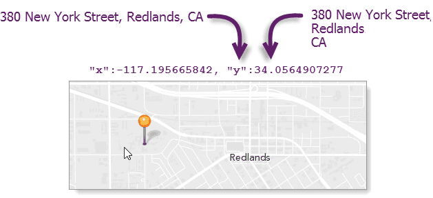
SingleLine=380 New York St, Redlands, California 92373address
A string that represents the first line of a street address. In most cases, this field will be used for street name and house number input, but it can also be used to input building name or place-name.
Example of address field input in the United States
address=380 New York StreetExample of address field input in Mexico
address=Avenida Revolucion 8208address2
A string that represents the second line of a street address. This can include street name/house number, building name, place-name, or subunit.
Example address2 field input
address2=Beetham Toweraddress3
A string that represents the third line of a street address. This can include street name/house number, building name, place-name, or subunit.
Example address3 field input
address3=Suite 4208neighborhood
The smallest administrative division associated with an address, typically, a neighborhood or a section of a larger populated place. A neighborhood is a subdivision of a city.
Example of a neighborhood in Mexico (colonia)
neighborhood=Herreracity
The next largest administrative division associated with an address, typically, a city or municipality. A city is a subdivision of a subregion or a region.
Example of a city in the U.S.
city=Los AngelesExample of a city in Mexico
city=Tijuanasubregion
The next largest administrative division associated with an address. Depending on the country, a subregion can represent a county, state, or province.
Example of a subregion (department) in France
subregion=Vienneregion
The largest administrative division associated with an address, typically, a state or province.
Example of a region in the U.S. (state)
region=FloridaExample of a region in Mexico (estado)
region=Baja Californiapostal
The standard postal code for an address, typically, a three– to six-digit alphanumeric code.
Example
postal=92373postalExt
A postal code extension, such as the United States Postal Service ZIP+4 code, provides finer resolution or higher accuracy when also passing postal .
Example
postalExt=1112countryCode
A value representing the country. Providing this value increases geocoding speed. Acceptable values include the full country name in English or the official language of the country, the two-character country code, or the three-character country code. A list of supported countries and codes is available in the Service data topic.
The source and country parameters are similar but serve different purposes. The country parameter defines the country value for a multifield geocode request. The source parameter defines the country value for a request regardless of whether it is a single-field or multifield request. If both country and source are included in a find request, and the country values are different, the country value takes priority over source .
Example
countryCode=USAmagicKey
The find operation retrieves results quicker when you pass in valid Single and magic values than when you don't pass in magic . However, to get these advantages, you need to make a prior request to suggest , which provides a magic . This may or may not be relevant to your workflow.
The suggest operation is often called on to improve the user experience of search boxes by analyzing partial text and providing complete names of places, addresses, points of interest, and so on. For instance, typing Mbu into a search box produces Mbuji-Mayi, Democratic Republic of the Congo as a suggestion, so the user doesn't need to type the complete name.
Looking at the suggestion process from another perspective, as the user types, the suggest operation performs a text search, which is a redundant part of the overall search that the find operation can also perform. The user chooses a place-name or type—narrowing the results to a specific record. The results from suggest include text and magic values that contain the information the user chose; passing these values from suggest into find results in faster and more accurate operations.
In summary, using the magic parameter in find is a two-step process:
- Make a request to
suggest. The response includestextandmagicproperties.Key - Make a request to
findand pass in theAddress Candidates textandmagicvalues returned fromKey suggestas theSingleandLine magicinput parameters, respectively. TheKey magicparameter will not function correctly if passed alone. BothKey magicandKey Singlemust be included in aLine findrequest so the output matches the selected suggestion.Address Candidates
Example
magicKey=JS91CYhQDS5vDPhvSMyGZby0YFbaUDoaM5bHMoFFsearchExtent
A set of bounding box coordinates that limit the search area to a specific region. This is especially useful for applications in which a user will search for places and addresses within the current map extent.
You can specify the spatial reference of the search coordinates, which is necessary if the map spatial reference is different than that of the ArcGIS Geocoding service; otherwise, the spatial reference of the coordinates is assumed to be the same as that of the ArcGIS Geocoding service.
The input can either be a comma-separated list of coordinates defining the bounding box or a JSON envelope object. The spatial reference of the bounding box coordinates can be included if an envelope object is used.
Refer to the Search within an extent section below for more details about using search .
Example without a spatial reference
searchExtent=-104,35.6,-94.32,41Example with a spatial reference
searchExtent=
{
"xmin": -13052769,
"ymin": 3951172,
"xmax": -13019630,
"ymax": 3978490,
"spatialReference": {
"wkid": 3395
}
}location
The location parameter defines an origin point that is used to prefer or boost geocoding candidates based on their proximity to the location. Candidates near the location are prioritized relative to those farther away. This is useful in mobile applications in which a user wants to search for places in the vicinity of their current GPS location, or in mapping applications in which users want to search for places near the center of the map.
The location can be represented with a simple comma-separated syntax (x,y), or as a JSON point object. If the comma-separated syntax is used, the spatial reference of the coordinates must be WGS84; otherwise, the spatial reference of the point coordinates can be defined in the JSON object.
Example using simple syntax (WGS84)
location=-117.196,34.056JSON example with a spatial reference
location=
{
"x": -13046165.572,
"y": 4036389.847,
"spatialReference": {
"wkid": 102100
}
}category
A place or address type that can be used to filter find results. The parameter supports input of single category values or multiple comma-separated values. The category parameter can be passed in a request with the Single or address parameters. It can also be passed in a request on its own without the singleline or address parameters. See Category filtering for details about the category parameter.
Example of category filtering with a single category
category=AddressExample of category filtering with multiple categories
category=Address,PostaloutSR
The spatial reference of the x,y coordinates returned by a geocode request. This is useful for applications using a map with a spatial reference different than that of the geocode service.
The spatial reference can be specified as either a well-known ID (WKID) or as a JSON spatial reference object. If out is not specified, the spatial reference of the output locations is the same as that of the service. The ArcGIS Geocoding service spatial reference is WGS84 (WKID = 4326).
For a list of valid WKID values, see Projected coordinate systems and Geographic coordinate systems.
Example (102100 is the WKID for the Web Mercator projection)
outSR=102100outFields
The list of fields to be returned within the attributes object of the response. Descriptions for each of these fields are available in the Output fields section of this document.
The address , location (x,y coordinates of the match location), score , extent , and spatial objects are returned in the response by default. If the out parameter is excluded from the request, or if it is included but no fields are specified, the attributes object in the corresponding response is blank.
Example that returns all output fields
outFields=*Example that returns the specified fields only
outFields=AddNum,StName,CitymaxLocations
The maximum number of locations to be returned by a search, up to the maximum number allowed by the service. If not specified, all matching candidates up to the service maximum are returned.
The ArcGIS Geocoding service allows up to 50 candidates to be returned for a single request.
Example
maxLocations=10forStorage
The for parameter specifies whether the results of the operation will be persisted. The default value is false , which indicates the results of the operation can't be stored, but they can be temporarily displayed on a map, for instance. If you store the results, in a database, for example, you need to set this parameter to true .
Applications are contractually prohibited from storing the results of geocoding transactions unless they make the request by passing the for parameter with a value of true and the token parameter with a valid token. Instructions for composing a request with a valid token are provided in Security and authentication.
To learn more about free and paid geocoding operations, see details about stored versus not stored geocoding.
Example
forStorage=truematchOutOfRange
A Boolean that specifies whether StreetAddress matches should be returned even when the input house number is outside of the house number range defined for the input street. Out-of-range matches have = . The geometry of such matches is a point corresponding to the end of the street segment where the range value is closest to the input house number. If match is not specified in a request, its value is set to true by default.
With match , better spatial accuracy is provided for inexact street address searches. Most street segments are assigned house number ranges. For example, Main Street may include house numbers from 2–100 on one side of the street and 1–99 on the other. A user may search for a house number that is not within this range, such as 109 Main Street. If match is passed in this request, the geocode service will return a StreetName-level match to Main Street, with geometry corresponding to the centroid of a street segment that most closely matches the input values. StreetName matches can be ambiguous because there may be multiple street segments with the same name that equally match the input. However, if match , in this case, a more precise geometry is returned to the specific side of the segment of Main Street with house number range 1–99.
Example
matchOutOfRange=falselocationType
The location parameter specifies whether the output geometry of PointAddress and Subaddress matches should be the rooftop point or street entrance location. Valid values are rooftop and street . The default value is rooftop .
Geocode results include one geometry object (the location object) that defines the location of the address, as well as two sets of x,y coordinate values within the attributes object: X /Y , and DisplayX /DisplayY . In most cases, for geocode results where Addr is Point or Subaddress , the X /Y attribute values describe the coordinates of the address along the street, while the Display /Display values describe the rooftop, or building centroid, coordinates. By default, the geometry returned for geocode results represents the rooftop location of the address (if the rooftop location is available in the source data). This is useful for most spatial analysis and map display purposes. However, for routing scenarios, it may be desirable to use the street location because the rooftop location of some addresses may be offset from a street by a large distance. For these cases, the location parameter can be used to specify that the street entrance geometry should be returned.
It is important to note that location is limited by the address data sources used by the ArcGIS Geocoding service. Not all PointAddress and Subaddress features include rooftop and street location coordinates. For some addresses, only a rooftop location is available; for others, only a street location is provided by the data source. For cases such as this, the location parameter may not function as expected. For example, if only rooftop location coordinates are available for an address, the rooftop geometry will be returned for the geocoded address even when location is requested.
Example
locationType=streetlangCode
The lang parameter sets the language in which geocode results are returned. Addresses and places in many countries are available in more than one language; in these cases, the lang parameter can be used to specify which language should be used for results returned by the find operation. This is useful for ensuring that results are returned in the expected language. For example, a web application could be designed to get the browser language and pass it as the lang parameter value in a find request.
See the table of supported countries for valid language code values in each country. The Supported Language Codes column provides the valid input values for the lang parameter. Full language names cannot be used with the lang parameter. Only one language code value can be included for the lang parameter in a find request.
If the lang parameter isn't included in a request, or if it is included but there are no matching features with the input language code, the resultant match is returned in the language code of the primary matched component from the input search string. Typically, this is either place-name or street name, depending on the search string.
Similarly, when there are multiple supported languages for a country, it doesn't mean that every address in the country is available in each of the languages. It may be the case that addresses are available in multiple languages for only one region of the country, or that each language is exclusive to a different region and there is no overlap. The following are some examples:
- French, German, and Italian are listed as supported languages for Switzerland. However, there is no overlap between the languages for addresses in most regions of the country. For instance, in the city of Geneva, only French addresses are available, while German is the only language used for addresses in the city of Bern.
- In Belgium, where three languages are supported (Dutch, French, and German), addresses are available in the city of Brussels in both Dutch and French. However, in the majority of the country, only a single language is used for addresses.
- In Greece, there is complete address coverage in both Greek and transliterated Greek languages (Greek words represented with Latin characters).
Due to variability of language coverage, the following logic is used to handle the different scenarios that may be encountered.
| Scenario | Result | Example |
|---|---|---|
Only one language is supported for an address, and no | Candidate is returned in the supported language. | Input (address in Geneva, Switzerland):
Output: |
Only one language is supported for an address, and an unsupported language is specified for the | Candidate is returned in the supported language. | Input (address in Geneva, Switzerland):
Output: |
Multiple languages are supported for an address, and no | Candidate is returned in the language of the primary matched component from the input string (street name or place-name). | Input (address in Brussels, Belgium):
Output: |
Multiple languages are supported for an address, and an unsupported language is specified for the | Candidate is returned in the language of the primary matched component from the input string (street name or place-name). | Input (address in Athens, Greece):
Output: |
Multiple languages are supported for an address, and a supported language is specified for the | Candidate is returned in the requested language. | Input (address in Athens, Greece):
Output: |
Example
langCode=frsourceCountry
The source parameter limits the candidates returned by the find operation to the specified country or countries. For example, if source is included in the request, it is assumed that the address is in the United States, so only matching addresses in the U.S. are returned. Using this parameter prevents potential unexpected results in other countries for ambiguous searches.
Acceptable values include the three-character country code. You can specify multiple country codes to limit results to more than one country.
A list of supported countries and codes is available in Service data.
Example: Single country
sourceCountry=USAExample: Multiple countries
sourceCountry=FRA,DEU,ESPpreferredLabelValues
The preferred parameter allows simple configuration of output fields returned in a response from the ArcGIS Geocoding service by specifying which address component values should be included in output fields. The parameter supports a single value or a comma-delimited collection of values as input. If the parameter is blank or excluded from a request, default address label formats will be used.
A particular address may have multiple city names associated with it. In the United States, for example, all addresses have a ZIP Code (postal code) assigned to them. Each ZIP Code has one or more associated locality names, which are known as postal cities. There is always one primary postal city value for each ZIP Code. ZIP Codes typically have no set boundaries, and the primary postal city name for the ZIP Code that is assigned to an address may be different than the name of the local city that the address is within.
For addresses in the United States, the ArcGIS Geocoding service includes the primary postal city in response output fields by default. As an example, postal code 45420 in Ohio has the primary postal city value Dayton. Addresses in the city of Kettering are assigned this postal code. It means that the default output fields for all geocoded addresses with postal code 45420, even those within the city of Kettering, will include Dayton as the city. To illustrate, if a user searches for 2109 E Dorothy Ln, O , the default match label returned in the response is 2109 E Dorothy Ln, Dayton, Ohio, 45420, even though the address is within the Kettering city limits.
Some organizations may prefer to include the local city name in the response instead of the postal city. The preferred parameter can be used for this purpose. For the previous example, if preferred is included in the request, the output match label in the response will be 2109 E Dorothy Ln, Kettering, Ohio, 45420.
Similarly, streets may be known by multiple names. This is especially true with highways. For example, Pearblossom Hwy in California, which is the primary name, is also known as CA-138. The ArcGIS Geocoding service allows matching to addresses using either name as input, and by default will return the name that was matched to in the response.
Some organizations may prefer that the primary street name be returned in the response even if a user searches for an alternate street name, and they can use the preferred parameter to accomplish this. In other words, if a user searches for C , and preferred is included in the request, the match label returned in the response is Pearblossom Hwy, Pearblossom, California, 93553.
See the following table for supported parameter values.
| Parameter value | Description |
|---|---|
postalCity | Include the primary postal city value in geocoding response output fields, even if it is different than the city name in the geocoding request. This is the primary name assigned to the postal code of the address. |
localCity | Include the primary local city name in geocoding response output fields, even if it is different than the city name in the geocoding request. This is the name of the city that the address is within, and may be different than the postal city. |
matchedCity | If the input city name in a geocoding request matches any of the local city or postal city names associated with an address, include the matched value in geocoding response output fields. If a city name is not included in the input, or is included but doesn't match to anything, default address formats will be used. |
primaryStreet | Include the primary street name in geocoding response output fields, even if it is different than the street name in the geocoding request. |
matchedStreet | If the input street name in a geocoding request matches any of the supported street names assigned to an address, include the matched value in geocoding response output fields. |
Here are additional details about the preferred parameter:
- The
preferredparameter takes a comma-delimited collection of values as input.Label Values - The parameter values correspond to two groups—a City group and a Street group, indicated by the suffix of the value name. The
postal,City local, andCity matchedvalues are part of the City group. TheCity primaryandStreet matchedvalues are part of the Street group.Street - A geocode request can include one City value and one Street value—for instance:
preferred.Label Values=primary Street,postal City - A request can only include one value per group. In other words, a request with
preferredis invalid.Label Values=matched City,postal City
Example: Single label value
preferredLabelValues=matchedCityExample: Multiple label values
preferredLabelValues=matchedCity,primaryStreetsearchWithin
The search parameter is used to specify the feature types for a collection of places that should be returned for a geocoded object. For example, search may be used to return all addresses that exist within a postal code, or all businesses located at a particular address.
Collections can be returned for geocoded PointAddress and PostalExt records only.
- For geocoded PointAddress records, collections of Subaddresses or POIs (or both) are supported.
- For geocoded PostalExt records, collections of PointAddresses, Subaddresses, or POIs (or any combination of these) are supported.
The search parameter also supports pagination. Because there may be hundreds or thousands of places that exist at or within a geocoded location, the search parameter is used along with the start and num parameters to break up large collections into manageable result sets, or pages, of 50 or fewer candidates. This is accomplished by passing consecutive requests to the ArcGIS Geocoding service with different start values.
To support pagination, the JSON response includes the following properties at the end of the response when a collection is returned for a search request:
| Property | Description |
|---|---|
total | The total count of candidates in the collection, including the geocoded object. |
start | The value that was passed in the request for the |
num | The number of candidates in the page. |
nextStart | The value that should be used for the start parameter in the subsequent |
If search is included in a find request, the request must also include a valid token; otherwise the request fails with an error.
See the following table for supported parameter values.
| Parameter value | Description |
|---|---|
PointAddress | Return all records of type PointAddress which are associated with a geocoded object of type PostalExt. |
Subaddress | Return all records of type Subaddress which are associated with a geocoded object of type PostalExt or type PointAddress. |
POI | Return all records of type POI which are associated with a geocoded object of type PostalExt or type PointAddress. |
Example: Single feature type
searchWithin=POIExample: Multiple feature types
searchWithin=PointAddress,Subaddress,POIstart
The start parameter is used along with the search and num parameters to page through large result sets of more than 50 candidates. It defines the result number to be returned as the first candidate in a page. The default value of start is 1.
The start parameter only functions when included in a request along with the search parameter.
Example
start=51num
The num parameter is used along with the search and Start parameters to page through large result sets of more than 50 candidates. It defines the number of candidates to be included in each page. The default value of num is 50. Valid values include any integer between 1 and 50. If a value larger than 50 is specified, no more than 50 candidates are returned in the response.
The num parameter only functions when included in a request along with the search parameter.
Example
num=20matchID
The match parameter allows you to search for an ID string value that represents an address or place. Match is also an output field which is available in a find response. The Match value can be obtained from a find response and then passed in a request at a later time. In most cases the Match value for a particular address will be constant across releases of the ArcGIS Geocoding service.
Example
matchID=AQFV9QAAmeQBAJUBBAAAAAAMD05FVyBZT1JLIFNUUkVFVBUDMzgwZgNFTkcreturnMatchNarrative
The return parameter is used to return detailed information about how a geocoding result was obtained by describing the way that each portion of an input string in a find request was processed, or classified, by the ArcGIS Geocoding service. When return is passed in a find request, this information is present in the Match output field as a JSON string. The field is part of the attributes object in the response.
The Match output field must also be specified in the outFields parameter, either implicitly or explicitly, as part of the find request.
To illustrate the type of information that is provided by return, if "380 New York Street, Redlands" is searched for, the Match field describes which part of the input was matched as house number ("380"), which part was matched as street name ("New York"), and so on.
Within the Match field each part of the input search string is represented with a sub-object. Each sub-object includes the following properties:
| Property | Description |
|---|---|
seq | The position of the component in the input string, represented as a number. For example, in "380 New York Street, Redlands", "380" is the first component of the string; the
|
field | The address component that the input part was matched to. For example, in "380 New York Street, Redlands", "380" is matched as house number; the
|
code | A code that describes how the input part was matched. In the "380 New York Street, Redlands" example, this would be the
|
input | The part of the input string that is being described. In the "380 New York Street, Redlands" example, this would be the
|
datum | The value in the ArcGIS Geocoding service reference data that the input part matched to. In the "380 New York Street, Redlands" example, this would be the
|
This is how the complete Match sub-object for "380" in "380 New York Street, Redlands" would appear:
{"seq":1,"field":"HouseNumber","code":"cm","input":"380","datum":"380"}The following table provides descriptions of the possible values for the code property. Note that multiple codes may be used to describe the match narrative for a particular input part.
| code | Description | Example |
|---|---|---|
c | Classified. Input word or part was recognized as an address value from the reference data, an alias, or an indicator of some kind. | |
m | Matched. Input word or part was matched to an address value in the reference data. | |
i | Inexact. Input word or part is spelled differently than what it matched to. | Input word "Avanue" matches to reference data street type value "Avenue". |
p | Partial. The input part matched to a portion of a value in the reference data. | Input part "110356" partially matches to reference data postal code value "110350" |
s | Split/concatenated. Indicates that a match was made to a value in the reference data by splitting one word from the input into multiple words, or by concatenating multiple words from the input into a single word. | Input word "Mountainview" matches to street name value "Mountain View" in the reference data. |
a | Aliased. The input part matched to an alias of a reference data value. | Input word "Boulevard" matches as an alias of reference data street type value "Blvd". |
r | Repositioned. Indicates that the input word was matched to a value in the reference data but in the wrong part of the overall address. | "North" is positioned as a prefix directional in input string "North Main Street" but matches to reference data value "Main Street North", which is a suffix directional. |
d | Different. Indicates that the input part was recognized as a particular address component but matched to a different reference data value for that component. | Input word "Street" matched to reference data street type value "Road". |
n | Nearby. Indicates that the input part matched to a postal code or administrative zone which is adjacent to the postal or zone that the geocoded address is actually within. | Input value "92026" matched to adjacent postal code "92027". |
e | Extrapolated. Indicates that the input part matched outside of the house number range for a StreetAddress record in the reference data. | Input value "280" matches to house number range "200-240" in the reference data. |
b | Interpolated. Indicates that the input house number matched via linear interpolation between two bordering PointAddress records. Request must include | Input house number value "410" matches between PointAddresses with house numbers "408" and "412". |
Example
returnMatchNarrative=truecomprehensiveZoneMatch
A Boolean that allows you to disable matching to inexact administrative zones or postal codes present in a find request.
By default the ArcGIS Geocoding service supports fuzzy matching of administrative zones (neighborhoods, districts, and cities) and postal codes when such values are present in searches for addresses and places. This is because admin zone and postal boundaries are often ambiguous, and a person may not know the exact neighborhood or postal code of the address they want to geocode.
If this fuzzy matching is not desired, you can include comprehensive in the request. Strict matching of admin zones and postal codes is used, and heavier penalties are applied to the result if the input admin or postal values aren't exactly matched.
Example
comprehensiveZoneMatch=falsereturnPrimaryMatchID
A Boolean that specifies whether the output Match value should contain the matched or primary version of the street or place name associated with the geocoded object.
This applies to cases where primary and alternate names exist for a street or place. For example, "Highway 156" may be the primary name for a particular street, and it may alternately be known as "Main Street". By default, the Match value will store the street or place name based on what was matched in the input. If "Main Street, Spokane, WA" is searched for, then "Main Street" is stored in the resulting Match value. However, if return is included in the request, and "Main Street, Spokane, WA" is searched for, then "Highway 156" will be stored in the output Match value instead, because it is the primary name for the street. If this Match value is subsequently searched for, then the output address label would be "Highway 156, Spokane, WA".
Example
returnPrimaryMatchID=trueexcludeIntersectionType
The exclude parameter prevents the specified intersection type from being returned in geocoding results. Currently the parameter is only be used to exclude virtual, or disconnected, intersections. By default all intersection types are allowed.
excludeIntersectionType=virtualinterpolatePointAddress
The interpolatePointAddress parameter can be used to return more spatially accurate geocoded locations for searches that don't resolve to rooftop point (PointAddress) locations.
By default PointAddress interpolation is disabled. Pass interpolate in the request to enable it. Geocoding candidates that are generated by PointAddress interpolation have Addr value PointAddressInt in the response.
Typically in the scenario where an input address doesn't match to a PointAddress, the ArcGIS Geocoding service falls back to a less accurate location along a street centerline and returns a StreetAddress or StreetName candidate. With this parameter enabled, the Geocoding service uses linear interpolation to calculate the location between the two adjacent PointAddress records with house numbers that the input house number is between. The input street name, administrative zones, and house number parity (odd or even number) must match the bordering PointAddress records for a PointAddressInt candidate to be generated. The location of a PointAddressInt candidate is along the line connecting the bordering PointAddress records. The distance of the PointAddressInt candidate to the bordering PointAddress records is proportional to the difference between its house number and the house numbers of the PointAddresses.
Example
interpolatePointAddress=trueResponse status
| Status | Meaning | Description | Schema |
|---|---|---|---|
200 | OK | A successful response for a | Inline |
400 | Bad request | Invalid query parameters. Learn more in Service output. | |
403 | Forbidden | The required paramter | |
5 | Unknown | An error occured on the server. Learn more in Service output. |
Go to Service output for extended codes.
Response details
{
"spatialReference": {
"wkid": "<spatialReference>",
"latestWkid": "<spatialReference>"
},
"candidates": [
{
"address":" <address>",
"location": {
"x": "<longitude>",
"y":" <latitude>"
},
"score": "<score>",
"attributes": {},
"extent": {
"xmin": "<minX>",
"ymin": "<minY>",
"xmax": "<maxX>",
"ymax": "<maxY>"
}
}
]
}
Examples
Input address examples
-
27488 Stanford Ave, Bowden, North Dakota380 New York St, Redlands, CA 92373
-
New York St and W Redlands Blvd, Redlands, CAJacques Veltmanstraat & Pieter Calandlaan, Amsterdam, NLD
-
Points of interest (POI) by name and type
Disneylandbanks in Parislos angeles starbucksmount everest
-
Administrative place names, such as city, county, state, province, or country names
Seattle, WashingtonState of MahārāshtraLiechtenstein
-
92591TW9 1 DN
-
-117.155579,32.703761
-
4400 Block of Perry St, Houston, Texas2400-3100 Block of San Bruno Ave, San Francisco
-
Streets between two cross streets
Conway Dr between Sheridan Ave and E El Norte Pkwy, EscondidoI-10 between exit 75 and exit 76, Redlands, CA
Search for a street address
You can pass the address components in a single parameter or separated into multiple parameters. Examples of each are shown. Note that in each case, the JSON response is the same for both the single- and multiple-parameter requests. See Match accuracy for more information about obtaining optimal results for address searches.
Single-field
GET https://geocode-api.arcgis.com/arcgis/rest/services/World/GeocodeServer/findAddressCandidates?SingleLine=380 New York Street, Redlands, CA 92373&category=&outFields=*&forStorage=false&f=pjson&token=<ACCESS_TOKEN>Multifield
In this example, the street address component (380 New York St) is passed as the value for the address parameter; the city component (Redlands) as the value for the city parameter; the state component (CA) as the region parameter; and the ZIP Code (92373) as the value for the postal parameter. Also in this example, all possible output fields are returned (out ), even if they don't contain a value.
GET https://geocode-api.arcgis.com/arcgis/rest/services/World/GeocodeServer/findAddressCandidates?Address=380 new york st&City=redlands&Region=CA&Postal=92373&outFields=*&forStorage=false&f=pjson&token=<ACCESS_TOKEN>Search for standard intersections
An intersection is where two streets cross each other. An intersection search consists of the intersecting street names plus the containing administrative division or postal code. For example, redlands blvd and new york st 92373 is a valid intersection search, as is redlands blvd & new york st redlands ca . For street intersection matches, Addr .
The valid intersection connectors can be found by looking up the Intersection property from the service info URL: https://geocode.arcgis.com/arcgis/rest/services/World/GeocodeServer?f=pjson.
Single-field
There are several types of intersections that can found by the ArcGIS Geocoding service. A typical simple intersection is formed by two street segments crossing each other. An example of this is W Park Ave and Tennessee St, Redlands, CA .
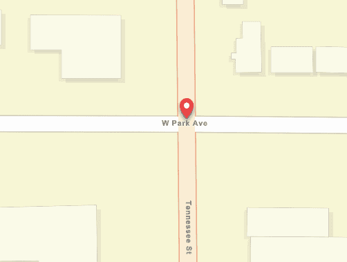
GET https://geocode-api.arcgis.com/arcgis/rest/services/World/GeocodeServer/findAddressCandidates?f=pjson&outFields=Addr_type&forStorage=false&SingleLine=W Park Ave and Tennessee St, Redlands, CA&token=<ACCESS_TOKEN>Multifield
GET https://geocode-api.arcgis.com/arcgis/rest/services/World/GeocodeServer/findAddressCandidates?f=pjson&outFields=Addr_type&forStorage=false&Address=W Park Ave and Tennessee St&City=Redlands&Region=CA&token=<ACCESS_TOKEN>Search for overpass intersections
You can also find intersections between streets that aren't physically connected. This includes cases where streets are separated by elevation, such as a highway overpass crossing over another street. An example of this is Pacific Hwy and W Washington St, San Diego, C .
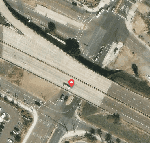
Single-field
GET https://geocode-api.arcgis.com/arcgis/rest/services/World/GeocodeServer/findAddressCandidates?f=pjson&outFields=Addr_type&forStorage=false&SingleLine=Pacific Hwy and W Washington St, San Diego, CA 92140&token=<ACCESS_TOKEN>Multifield
GET https://geocode-api.arcgis.com/arcgis/rest/services/World/GeocodeServer/findAddressCandidates?f=pjson&outFields=Addr_type&forStorage=false&Address=Pacific Hwy and W Washington St&City=San Diego&Region=CA&Postal=92140&token=<ACCESS_TOKEN>Search for disconnected intersections
An intersection can also be formed by two disconnected streets when one street ends close to another, such as a cul-de-sac or a dead end. In cases such as this, if the streets are within a certain distance of each other, the ArcGIS Geocoding service returns a StreetInt match when they are searched for. This near-intersection tolerance is currently 60 meters. An example of this type of near-intersection is Knowlton St and Turner Ct, Somerville, Massachusetts, USA . Disconnected intersections are also referred to as virtual intersections.
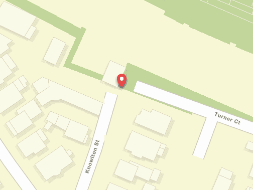
Single-field
GET https://geocode-api.arcgis.com/arcgis/rest/services/World/GeocodeServer/findAddressCandidates?f=pjson&outFields=Addr_type,Type&forStorage=false&SingleLine=Knowlton St and Turner Ct, Somerville, Massachusetts, USA&token=<ACCESS_TOKEN>Multifield
GET https://geocode-api.arcgis.com/arcgis/rest/services/World/GeocodeServer/findAddressCandidates?f=pjson&outFields=Addr_type&forStorage=false&Address=Knowlton St and Turner Ct&City=Somerville&Region=Massachusetts&CountryCode=USA&token=<ACCESS_TOKEN>You can prevent virtual intersections from being returned in geocoding results by using the excludeIntersectionType parameter. For the previous example, when exclude is included in the find request, the intersection match is no longer returned.
Single-field
GET https://geocode-api.arcgis.com/arcgis/rest/services/World/GeocodeServer/findAddressCandidates?excludeIntersectionType=virtual&maxLocations=2&f=pjson&outFields=Addr_type,Type&forStorage=false&SingleLine=Knowlton St and Turner Ct, Somerville, Massachusetts, USA&token=<ACCESS_TOKEN>Multifield
GET https://geocode-api.arcgis.com/arcgis/rest/services/World/GeocodeServer/findAddressCandidates?excludeIntersectionType=virtual&maxLocations=2&f=pjson&outFields=Addr_type&forStorage=false&Address=Knowlton St and Turner Ct&City=Somerville&Region=Massachusetts&CountryCode=USA&token=<ACCESS_TOKEN>Search for roundabout intersections
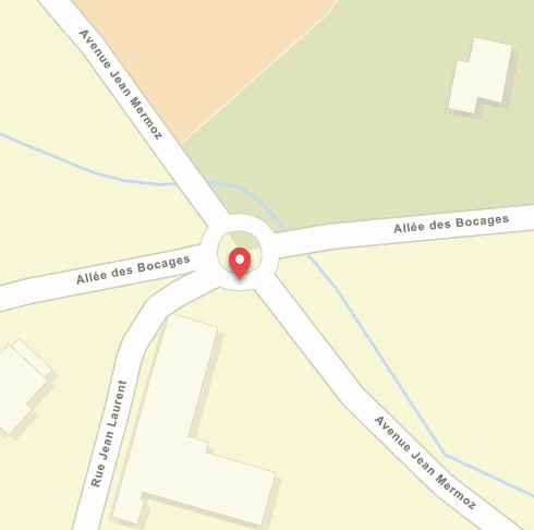
Another type of disconnected intersection supported by the ArcGIS Geocoding service occurs at roundabouts. A roundabout is formed when two or more streets connect to a circular roadway, which is often unnamed. The participating streets typically don't connect directly to each other, but when they are searched for and are within the near-intersection tolerance, the service returns a StreetInt match. An example of a roundabout intersection is Rue Jean Laurent & Avenue Jean Mermoz, Le Vésinet, FRA .
Single-field
GET https://geocode-api.arcgis.com/arcgis/rest/services/World/GeocodeServer/findAddressCandidates?f=pjson&outFields=Addr_type&forStorage=false&SingleLine=Rue Jean Laurent and Avenue Jean Mermoz, Le Vésinet, FRA&token=<ACCESS_TOKEN>Multifield
GET https://geocode.arcgis.com/arcgis/rest/services/World/GeocodeServer/findAddressCandidates?f=pjson&outFields=Addr_type&forStorage=false&Address=Rue Jean Laurent and Avenue Jean Mermoz&City=Le Vésinet&CountryCode=FRA&token=<ACCESS_TOKEN>Find an ambiguous intersection
Sometimes there may be multiple possible matches for an intersection search. This typically occurs when divided roads cross each other. A divided road consists of two street segments separated by a median. In a scenario such as this, there could be up to four equivalent intersection matches consisting of the same street names at different locations. The ArcGIS Geocoding service uses an ambiguous intersection tolerance with such searches to remove redundant intersection candidates from the response. The ambiguous intersection tolerance is currently 30 meters. Specifically, if there are multiple intersection candidates with the same street names that are located in the same locality (meaning same neighborhood, city, postal code), and if they are within 30 meters of each other, the service returns only one of the candidates.
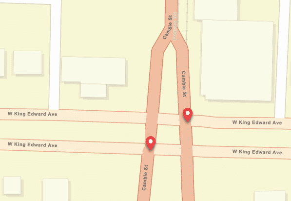
An example of an ambiguous intersection search is Cambie St and W King Edward Ave, Vancouver, British Columbia . Both Cambie St and W King Edward Ave are divided streets, so there are four potential intersection candidates with the same street names. However, there is a boundary between the neighborhoods of South Cambie and Riley Park which happens to follow the middle of Cambie St. Because of this, there are actually two sets of equivalent intersections—one within South Cambie (on left side of Cambie St) and the other within Riley Park (on the right side of Cambie St). The locations of the potential intersection candidates in each set are within the ambiguous intersection distance from each other, so two intersection candidates are returned in the response for this search—one in South Cambie, and the other in Riley Park.
Single-field
GET https://geocode-api.arcgis.com/arcgis/rest/services/World/GeocodeServer/findAddressCandidates?f=pjson&outFields=Addr_type,Nbrhd&forStorage=false&SingleLine=Cambie St and W King Edward Ave, Vancouver, British Columbia&token=<ACCESS_TOKEN>Multifield
GET https://geocode-api.arcgis.com/arcgis/rest/services/World/GeocodeServer/findAddressCandidates?f=pjson&outFields=Addr_type,Nbrhd&forStorage=false&Address=Cambie St and W King Edward Ave&City=Vancouver&Region=British Columbia&token=<ACCESS_TOKEN>Search for POIs
A POI is a point location that can represent a cultural or geographic landmark, business, or administrative division. For example, you can find amusement parks, museums, schools, restaurants, hotels, gas stations, or other types of businesses or landmarks; geographic features, such as mountains, lakes, rivers, or deserts; or administrative places, such as neighborhoods, cities, states, counties, or countries. The find operation supports geocoding POIs by name or by type. The supported types are listed in this table.
As with street addresses, you can search for POIs with find using the single-field or multifield approach.
Single-field POI search
To search for POIs with single-field search, use the Single parameter. In general, valid Single POI search strings can be formatted in variations of three basic structures:
- <name or type> <optional connector> <zone>
- <zone> <name or type>
- <name or type><address><zone>
Where
- <name or type> = A place-name, such as Disneyland, Starbucks, or Niagara Falls; or a type, such as amusement parks, waterfalls, or coffee shops.
- <zone> = A postal code or administrative boundary—such as neighborhood, city, subregion, region, country, or any combination thereof—that provides a spatial boundary to the search. It can be included in the search to limit matching candidates but is not required.
- <optional connector> =
inorat; this is not required for the search. - <address> = A street name, such as
Main St, or a complete street address, such as590 N Main St.
Examples of valid Single search strings include the following:
Business name searches
- Starbucks San Diego
- Starbucks in San Diego
- San Diego Starbucks
- Starbucks 92101
- Starbucks 5th Ave San Diego
- Reuben H Fleet Science Center, 1875 El Prado, San Diego, CA, 92101, USA
Type searches
- coffee shops San Diego
- coffee shops in San Diego CA
- San Diego coffee shops
- coffee shops 92101
- coffee shops 5th Ave San Diego
Multifield POI search
When searching for POIs using multifield input, the name or type of the POI must be passed as the value for the address parameter. The zone information can be passed in the postal , neighborhood , city , subregion , region , and country parameters. If searching for POI + address, the address should be passed as the value for the address2 parameter.
General information
It is important to note that instead of providing a zone, you can limit searches to a specific area by using the search parameter. You can also influence the sorting of match candidates according to their proximity to a location with the location parameter.
As with address searches, the quality of POI search results is dependent on the amount and quality of information in the search string. If you only search for hotels without qualifying information, such as zone, search extent, or location, your results will not be meaningful. Adding supplemental information to the search string—the more specific, the better—will result in more accurate and relevant matches.
There may be instances when searches yield unexpected results. For example, a search for New York pizza , in which the expected results are pizzerias in New York City, may instead return a match to a restaurant named New York Pizza in Sacramento, California. This is because exact place-name matches are given higher priority to increase performance. If this occurs, you can obtain the desired results by modifying the search string—in this case, a search for pizza in NYC should yield the expected results.
The address, phone number, and website URL of a POI can be returned by including out in the request. But not all POIs have address, phone, and URL values associated with them. See Service output for more information about these output fields.
Find a business name
Single-field
GET https://geocode-api.arcgis.com/arcgis/rest/services/World/GeocodeServer/findAddressCandidates?SingleLine=starbucks sydney AUS&outFields=type,city,region&maxLocations=1&forStorage=false&f=pjson&token=<ACCESS_TOKEN>Multifield
GET https://geocode-api.arcgis.com/arcgis/rest/services/World/GeocodeServer/findAddressCandidates?Address=starbucks&Neighborhood=&City=sydney&Subregion=&Region=&CountryCode=AUS&outFields=type,city,region&maxLocations=1&forStorage=false&f=pjson&token=<ACCESS_TOKEN>Find a business type
GET https://geocode-api.arcgis.com/arcgis/rest/services/World/GeocodeServer/findAddressCandidates?SingleLine=hotels orlando FL&outFields=type,city,region&forStorage=false&f=pjson&token=<ACCESS_TOKEN>Find a business on a specific street
Single-field
GET https://geocode-api.arcgis.com/arcgis/rest/services/World/GeocodeServer/findAddressCandidates?singleLine=starbucks 5th ave san diego&langCode=&outFields=Place_Name,Place_addr,Phone,Type,Addr_type&forStorage=false&f=pjson&token=<ACCESS_TOKEN>Multifield
GET https://geocode-api.arcgis.com/arcgis/rest/services/World/GeocodeServer/findAddressCandidates?address=starbucks&address2=5th ave&city=san diego&outFields=Place_Name,Place_addr,Phone,Type,Addr_type&forStorage=false&f=pjson&token=<ACCESS_TOKEN>Search for administrative place names
The find operation supports single-field and multifield searches for administrative place-names. This includes searches for neighborhoods, cities, counties, states, provinces, or countries. If a search for a city name results in multiple matches with the same name, the ArcGIS Geocoding service will sort the candidates in order of their relative importance to each other (as indicated by the value of the Rank output field), with priority generally based on population and capital status.
For example, there are many cities in the world named San Francisco, so a search for San Francisco results in several equivalent matches; San Francisco, California, USA, will always be the top candidate since it has the greatest population.
However, rank alone is not always enough to distinguish between administrative places. Also, you may not necessarily want to find the highest-ranked feature for a particular search. It may be necessary to remove ambiguity by refining searches with additional information. For example, a search for Oxford returns Oxford, UK, as the top candidate based on rank. If you instead want to find the town of Oxford, Ohio, it is necessary to add the state information to the search.
Find a city name
Single-field
GET https://geocode-api.arcgis.com/arcgis/rest/services/World/GeocodeServer/findAddressCandidates?SingleLine=San%20Francisco&forStorage=false&f=pjson&token=<ACCESS_TOKEN>Multifield
GET https://geocode-api.arcgis.com/arcgis/rest/services/World/GeocodeServer/findAddressCandidates?address=San%20Francisco&f=pjson&token=<ACCESS_TOKEN>Search for a city in a state
Single-field
GET https://geocode-api.arcgis.com/arcgis/rest/services/World/GeocodeServer/findAddressCandidates?SingleLine=oxford%20OH&forStorage=false&f=pjson&token=<ACCESS_TOKEN>Multifield
GET https://geocode-api.arcgis.com/arcgis/rest/services/World/GeocodeServer/findAddressCandidates?address=Oxford®ion=OH&f=pjson&token=<ACCESS_TOKEN>Search for postal codes
The find operation supports searches for postal codes and postal code extensions. When searching for postal codes, it is important to note that the same code can be valid in more than one country; for best results, it may be necessary to include additional information with the postal code, such as city or country.
Find a postal code
Single-field
GET https://geocode-api.arcgis.com/arcgis/rest/services/World/GeocodeServer/findAddressCandidates?SingleLine=20002 USA&forStorage=false&outFields=addr_type&f=pjson&token=<ACCESS_TOKEN>Multifield
GET https://geocode-api.arcgis.com/arcgis/rest/services/World/GeocodeServer/findAddressCandidates?postal=20002&countryCode=USA&outFields=addr_type&f=pjson&token=<ACCESS_TOKEN>Search for coordinates
The ArcGIS Geocoding service supports searches for coordinates. The output is a geometry point with a match address that is the same as the input coordinates. This is different than reverse geocoding, in which input x,y coordinates are resolved to a matching street address; see reverseGeocode for more information. The following types of coordinate search are supported:
- x,y coordinates; x refers to longitude (east-west coordinates), and y refers to latitude (north-south coordinates)
- Military Grid Reference System (MGRS) coordinates
- United States National Grid (USNG) coordinates
Coordinates must be passed as the value for the Single or Address field in the request. If the coordinates are included in the Address field, all other input fields, such as Address2 , City , Region , and Postal , must be empty.
MGRS and USNG coordinates can be searched with various precisions, from 10,000-meter square to 1-meter square precision. See the table below for examples of valid MGRS or USNG search input.
MGRS/USNG examples
18SUH64 | 10,000-meter square | 2-digit coordinate |
18SUH6743 | 1,000-meter square | 4-digit coordinate |
18SUH678432 | 100-meter square | 6-digit coordinate |
18SUH67894321 | 10-meter square | 8-digit coordinate |
18SUH6789043210 | 1-meter square | 10-digit coordinate |
Input x,y coordinates can be formatted in several ways:
-
Coordinates can be input in either <longitude>,<latitude> or <latitude>,<longitude> order, and can be separated with either a comma or a space.
-
Coordinates can be input in decimal degrees (DD) or degrees minutes seconds (DMS) format.
-
Quadrants can be signified by using a minus sign (-) before the numeric value to signify the western or southern quadrants, or by using E, W, N, or S directional indicators before or after the numeric values.
-
DMS coordinates can be separated with ° (degrees), ' (minutes), and " (seconds) symbols.
-
DMS coordinates can also be separated with the letters
d(degrees),m(minutes), ands(seconds).
The following tables shows examples of different formats that can be used to search x,y coordinates.
Decimal degrees examples
| Longitude | Latitude | Example search input |
|---|---|---|
-14 | 28.4 | -14 28.4 |
14 W | 28.4 N | 45 W, 45 N |
14.09W | 28.37N | 14.09W 28.37N |
W14 | N28.4 | W14, N28.4 |
X: -14 | Y: 28.4 | X: -14 Y: 28.4 |
-14.079085 | 28.413518 | -14.079085, 28.413518 |
Degrees minutes seconds examples
| Longitude | Latitude | Example search input |
|---|---|---|
14°05'20" W | 28°25'01" N | 14°05'20" W 28°25'01" N |
-14°05'20" | 28°25'01" | -14°05'20",28°25'01" |
X:-14°05'20" | Y:28°25'01" | X:-14°05'20" Y:28°25'01" |
14° 05' 20" W | 28° 25' 01" N | 14° 05' 20" W 28° 25' 01" N |
14d05m20s W | 28d25m01s N | 14d05m20s W 28d25m01s N |
-14d05m20s | 28d25m01s | -14d05m20s,28d25m01s |
X:-14d05m20s | Y:28d25m01s | X:-14d05m20s Y:28d25m01s |
14d 05m 20s W | 28d 25m 01s N | 14d 05m 20s W 28d 25m 01s N |
Searches for x,y coordinates can be ambiguous, because some users may place the longitude (x) coordinate first, while others may place the latitude (y) coordinate first. For instance, a search for x,y coordinates 80,50 produces very different results when longitude is first than when latitude is first. The service handles this by returning candidates in both <latitude and <longitude formats for ambiguous coordinate searches. The ArcGIS Geocoding service returns two or three candidates with the following possible Addr values for x,y coordinate searches:
Lat—Returned when the first coordinate in the input is either explicitly or implicitly determined to be the longitude coordinate. The correspondingLong Matchvalue is formatted as_addr <longitude, such as> <latitude > 10.000000 50.000000.XY—Returned when the first coordinate in the input is either explicitly or implicitly determined to be the longitude coordinate. The correspondingMatchvalue is formatted as_addr X, such as:<longitude > Y :<latitude > X.:10.000000 Y :50.000000 YX—Returned when the first coordinate in the input is either explicitly or implicitly determined to be the latitude coordinate. The correspondingMatchvalue is formatted as_addr Y, such as:<latitude > X :<longitude > Y.:50.000000 X :10.000000
Details about the logic used by the service for x,y coordinate searches are listed below.
- For ambiguous x,y searches in which both input coordinates are valid as either latitude or longitude, three candidates are returned, one for each of the
Addrvalues listed above. Example—_type 10,50 - For x,y searches in which the longitude and latitude coordinates are explicitly defined by X/Y or directional (N, S, E, W) indicators, and the longitude value precedes the latitude value,
LatandLong XYcandidates are returned. Example—10orW,50 N X:10, Y :50 - For x,y searches in which the longitude and latitude coordinates are explicitly defined by X/Y or directional (N, S, E, W) indicators, and the latitude value precedes the longitude value, only a
YXcandidate is returned. Example—50orN,10 W Y:50, X :10 - If one of the input coordinates is outside the valid range of latitude values and the service can implicitly determine that it is the longitude, and the longitude value precedes the latitude value,
LatandLong XYcandidates are returned. Example—-120,50 - If one of the input coordinates is outside the valid range of latitude values and the service can implicitly determine that it is the longitude, and the latitude value precedes the longitude value, only a
YXcandidate is returned. Example—50,-120
You can also use the category parameter to disambiguate x,y coordinate searches.
Find MGRS / USNG coordinates
Single-field
GET https://geocode-api.arcgis.com/arcgis/rest/services/World/GeocodeServer/findAddressCandidates?f=pjson&outFields=Addr_type&maxLocations=1&forStorage=false&SingleLine=18SUH6789043210&token=<ACCESS_TOKEN>Multifield
GET https://geocode-api.arcgis.com/arcgis/rest/services/World/GeocodeServer/findAddressCandidates?f=pjson&outFields=Addr_type&maxLocations=1&forStorage=false&Address=18SUH6789043210&token=<ACCESS_TOKEN>Search for street blocks
The find operation supports searches for a group of house numbers representing one or more city blocks. The Addr value returned for this type of search is StreetMidBlock. The location of such a feature is the approximated midpoint of the street segments that include the house numbers represented by the block number or block range. A StreetMidBlock match is more precise than a StreetName match, and less precise than a StreetAddress match.
A single block, or a range of blocks, may be searched for. Here are some examples of StreetMidBlock searches:
- 100 block of New York St, Redlands, CA
- 1600 blk E Cliff Dr, El Paso
- 200-500 block Taylor St, San Francisco
- 1700-1900 blk of Locust St, Philadelphia, Pennsylvania
For a StreetMidBlock match to be returned, the input text must follow this general syntax:
<number or range block | block of <street name
StreetMidBlock matching is useful for situations in which an exact address is unknown, such as emergency reporting. For example, a bystander witnessing an emergency may know the name of the street they're on and the general house numbers in their vicinity, but not the exact house number—emergency responders can use the block information to quickly find the approximate location of the incident.
It's also useful for workflows in which anonymity is required for privacy concerns, such as crime data analysis by law enforcement agencies. In such cases, when law enforcement personnel respond to an incident, the street block where the incident occurred can be recorded instead of a person's complete address. StreetMidBlock matching is currently supported for the United States only.
Find a single block number
Single-field
GET https://geocode-api.arcgis.com/arcgis/rest/services/World/GeocodeServer/findAddressCandidates?SingleLine=100%20block%20of%20New%20York%20St%2C%20Redlands%2C%20CA&outFields=Addr_type&f=pjson&token=<ACCESS_TOKEN>Multifield
GET https://geocode-api.arcgis.com/arcgis/rest/services/World/GeocodeServer/findAddressCandidates?address=100%20block%20of%20New%20York%20St&city=Redlands®ion=CA&outFields=addr_type&f=pjson&token=<ACCESS_TOKEN>Find a range of blocks
Single-field
GET https://geocode-api.arcgis.com/arcgis/rest/services/World/GeocodeServer/findAddressCandidates?SingleLine=200%2D500%20block%20Taylor%20St%2C%20San%20Francisco&outFields=Addr_type&f=pjson&token=<ACCESS_TOKEN>Multifield
GET https://geocode-api.arcgis.com/arcgis/rest/services/World/GeocodeServer/findAddressCandidates?address=200-500%20block%20Taylor%20St&city=San%20Francisco&outFields=addr_type&f=pjson&token=<ACCESS_TOKEN>Search for a street between two cross streets
The find operation supports searching for a street between two intersecting cross streets. The Addr value returned for this type of search is StreetBetween. The location of such a feature is along the matched street at the midpoint between the cross streets. The precision of a StreetBetween match is greater than a StreetName match, less than a StreetAddress match, and equal to a StreetMidBlock match.
Here are some examples of StreetBetween searches:
- Conway Dr between Sheridan Ave and E El Norte Pkwy, Escondido, CA
- I-10 bt exit 75 and exit 76, Redlands, CA
- Pinckney btw Joy & Anderson, Boston
For a StreetBetween match to be returned, the input text must follow this general syntax:
<street name between | btw | bt <cross street one and <cross street two
Similar to StreetMidBlock, StreetBetween matching is useful for situations in which an exact address or location is unknown, such as emergency reporting. For example, a person involved in an incident may know the name of the street they're on and the nearby intersecting streets but not an exact address—emergency responders can use this information to quickly find the approximate location of the incident.
StreetBetween matching is currently supported for Canada and the United States only.
Find a street between two cross streets
Single-field
GET https://geocode-api.arcgis.com/arcgis/rest/services/World/GeocodeServer/findAddressCandidates?singleline=Conway%20Dr%20between%20Sheridan%20Ave%20and%20E%20El%20Norte%20Pkwy%2C%20Escondido%2C%20CA&outFields=Addr_type&f=pjson&token=<ACCESS_TOKEN>Multifield
GET https://geocode-api.arcgis.com/arcgis/rest/services/World/GeocodeServer/findAddressCandidates?address=Conway%20Dr%20between%20Sheridan%20Ave%20and%20E%20El%20Norte%20Pkwy&city=Escondido®ion=CA&outFields=Addr_type&f=pjson&token=<ACCESS_TOKEN>Specify individual outfields for a POI search
The find operation allows you to specify individual output fields or return all output fields. The out parameter is used for this. If you want to return all supported output fields, set out ; if you only want to return the default output fields, out does not need to be passed in the request. If you want to return specific fields, pass the desired field names as comma-separated values, such as out , which returns the name, feature type, city, and country for a POI search.
Single-field
GET https://geocode-api.arcgis.com/arcgis/rest/services/World/GeocodeServer/findAddressCandidates?singleLine=coffee shops Christchurch NZL&outFields=PlaceName,Type,City,Country&f=pjson&token=<ACCESS_TOKEN>Specify the output spatial reference
By default, the ArcGIS Geocoding service returns candidate geometry in WGS84 coordinates (decimal degrees). You can specify a different spatial reference for output coordinates by using the out parameter. This is necessary if you have a mapping application in which you display geocoding candidates and the map spatial reference is not WGS84. For example, the ArcGIS.com basemaps use a Web Mercator spatial reference, with coordinates in meters. To display geocoding candidates correctly in such a map, you would need to set out , which is the well-known ID (WKID) of the Web Mercator spatial reference.
For a list of valid WKID values, see Projected coordinate systems and Geographic coordinate systems.
Single-field
GET https://geocode-api.arcgis.com/arcgis/rest/services/World/GeocodeServer/findAddressCandidates?SingleLine=380 new york st redlands ca&outSR=102100&f=pjson&token=<ACCESS_TOKEN>Multifield
GET https://geocode-api.arcgis.com/arcgis/rest/services/World/GeocodeServer/findAddressCandidates?address=380 new york st&city=redlands®ion=ca&outSR=102100&f=pjson&token=<ACCESS_TOKEN>Specify the maximum number of candidates
The max parameter allows you to specify the maximum number of candidates to be returned by a search, up to the maximum number of candidates allowed by the ArcGIS Geocoding service. By default, the service allows up to 50 candidates to be returned for searches. As an example, if you set max , find will return the top 10 candidates for the search. If no value is specified for max , find returns all matching candidates.
Single-field
GET https://geocode-api.arcgis.com/arcgis/rest/services/World/GeocodeServer/findAddressCandidates?singleLine=starbucks in redlands&outFields=PlaceName,City,Country&maxLocations=2&f=pjson&token=<ACCESS_TOKEN>Multifield
GET https://geocode-api.arcgis.com/arcgis/rest/services/World/GeocodeServer/findAddressCandidates?address=starbucks&city=redlands&outFields=PlaceName,City,Country&maxLocations=2&f=pjson&token=<ACCESS_TOKEN>Search within an extent
The find operation allows spatial filtering of search results by using the search parameter. If you want to confine a search to a localized area, something that is especially useful in a mobile application, you can define a bounding rectangle to search within. No candidates outside of the rectangle are returned. Bounding rectangle coordinates can be entered as a simple comma-separated string in the format <lower left corner>,<upper right corner>. If the simple format is used, the coordinates must be in the default spatial reference of the geocode service, which is WGS84. The search parameter can be used with all supported search types (street address, POI, admin place, postal code).
The search parameter is not intended to be used with extents that cover large areas, such as entire countries or provinces/states. Geocoding quality and performance may be reduced with large search values. For example, if a request includes a search that covers the state of California, an ambiguous input address such as 100 Main St would cause an excessive number of matching candidates to be generated, which would slow down the response. To counteract such a delay, the service may not process all possible candidates, leading to unexpected results.
The following best practices will help you avoid issues when using search :
- Reduce the
searcharea. Ideally, the size of the extent should not exceed an area corresponding to a map scale of approximately 1:1,000,000.Extent - Include an administrative zone (such as city) or postal code in the request when searching for a place or address. For instance, instead of searching for
100 Main St, be more specific and search for100 Main St, Barstow. - Use the
suggestoperation together withfindto take advantage of its autocomplete capability.Address Candidates
Find POIs using searchExtent with default spatial reference
Single-field
GET https://geocode-api.arcgis.com/arcgis/rest/services/World/GeocodeServer/findAddressCandidates?singleLine=mcdonalds&outFields=city,type&searchExtent=-117.172026,32.706517,-117.152498,32.725514&f=pjson&token=<ACCESS_TOKEN>Multifield
GET https://geocode-api.arcgis.com/arcgis/rest/services/World/GeocodeServer/findAddressCandidates?address=mcdonalds&outFields=city,type&searchExtent=-117.172026,32.706517,-117.152498,32.725514&f=pjson&token=<ACCESS_TOKEN>You can specify a spatial reference for the search , which is necessary if your map uses a different spatial reference than the geocode service. For example, the default ArcGIS.com basemaps use a Web Mercator spatial reference (WKID = 102100), with coordinates in meters. The search must be passed as a JSON envelope object if the coordinates are in a spatial reference other than WGS84. The following request URL uses the previous example of McDonald's in downtown San Diego, but specifies the bounding rectangle with Web Mercator coordinates.
Note that, in this example, the out property is set to 102100 , so the output coordinates are also in Web Mercator coordinates. If out was left blank, the coordinates would be returned in the WGS84 spatial reference.
For a list of supported spatial references and their WKID values, see Projected coordinate systems and Geographic coordinate systems.
Find POIs using searchExtent with Web Mercator spatial reference
Single-field
GET https://geocode-api.arcgis.com/arcgis/rest/services/World/GeocodeServer/findAddressCandidates?singleLine=mcdonalds&outFields=City%2CType&searchExtent=%7B%22xmin%22%3A-13043558%2C%22ymin%22%3A3856395%2C%22xmax%22%3A-13041325%2C%22ymax%22%3A3858918%2C%22spatialReference%22%3A%7B%22wkid%22%3A102100%7D%7D&outSR=102100&f=pjson&token=<ACCESS_TOKEN>Multifield
GET https://geocode-api.arcgis.com/arcgis/rest/services/World/GeocodeServer/findAddressCandidates?address=mcdonalds&outFields=City%2CType&searchExtent=%7B%22xmin%22%3A-13043558%2C%22ymin%22%3A3856395%2C%22xmax%22%3A-13041325%2C%22ymax%22%3A3858918%2C%22spatialReference%22%3A%7B%22wkid%22%3A102100%7D%7D&outSR=102100&f=pjson&token=<ACCESS_TOKEN>Requests that include search can also include zone information (that is, city, state, and country). If the extent defined for search is large enough to encompass multiple cities, it may be necessary to include the city name in the search to achieve optimal results. For example, if the search covers the Dallas-Fort Worth metropolitan region, and you search for Starbucks , there could be matches returned in Dallas or Fort Worth or any of their suburbs. If you specifically want to find Starbucks in Garland, for example, this needs to be specified in the search.
Find POIs using searchExtent and zone
Single-field
GET https://geocode-api.arcgis.com/arcgis/rest/services/World/GeocodeServer/findAddressCandidates?singleLine=starbucks%20garland&outFields=type%2Ccity%2Cregion&searchExtent=-97.407282%2C32.416436%2C-96.537829%2C33.141819&f=pjson&token=<ACCESS_TOKEN>Multifield
GET https://geocode-api.arcgis.com/arcgis/rest/services/World/GeocodeServer/findAddressCandidates?address=starbucks&city=garland&outFields=type,city,region&searchExtent=-97.407282,32.416436,-96.537829,33.141819&f=pjson&token=<ACCESS_TOKEN>You can also search for street addresses within an extent. When the search parameter is defined for an address search, city and postal code can be omitted from the search and valid matches can still be found. However, if the search is large, it is possible for a street address to occur multiple times within the extent, and it may be necessary to refine the search by including city, state, postal code, or other distinguishing information. Additionally, if the search includes a city or postal code that is outside the search , no matches will be returned. See the following example, which illustrates finding a street address using search .
Find a street address using searchExtent
Single-field
GET https://geocode-api.arcgis.com/arcgis/rest/services/World/GeocodeServer/findAddressCandidates?singleLine=380 new york st&searchExtent=-117.225635,34.015757,-117.119866,34.087402&f=pjson&token=<ACCESS_TOKEN>Multifield
GET https://geocode-api.arcgis.com/arcgis/rest/services/World/GeocodeServer/findAddressCandidates?address=380 new york st&searchExtent=-117.225635,34.015757,-117.119866,34.087402&f=pjson&token=<ACCESS_TOKEN>Proximity searches
Geocoding results are typically sorted according to their relevance to the search and their relative importance. However, with some applications, especially mobile apps, users are more concerned with finding features closest to their current location. For this reason, the find operation supports prioritization of candidates based on their distance from a specified point. By passing in the location parameter, you can define an area of influence for your searches. The location value represents the center point of the area, which spans a radius of 50,000 meters. Features closest to the input location show up higher in the list of candidates. Results that are within the area of influence area receive a greater boost than those outside the area.
It is important to note that proximity search does not filter results that are farther than 50,000 meters from the input location—it is intended to influence the sort order of results so the most locationally relevant candidates are returned first. For instance, if your location is in Las Vegas, and you search for Bellagio, the first candidate is Bellagio in Las Vegas. The second candidate is in a different part of the United States, much farther away than 50,000 meters, but is still returned because it is the second most relevant (closest) candidate. In general, the number of candidates returned by a proximity search is only limited by the max parameter.
The location parameter can be used in place of administrative zone (city) or postal code in an address search, as long as a matching address exists within 50 kilometers of the input location. Consider the following example.
251 Vesey St, New York, 10282is an address in Manhattan, New York City.- Coordinates
-74.006,40.71437represent a point within central Manhattan, less than 1 kilometer away from the address.
If you search for 251 Vesey St (no city or postal) with location=-74.006,40.71437 included in the request, a match to 251 Vesey St, New York, 10282 is returned. However, if instead you search for 251 Vesey St with a location value in Washington, DC (350 kilometers away), an address match is not returned.
Find a place name
Single-field
GET https://geocode-api.arcgis.com/arcgis/rest/services/World/GeocodeServer/findAddressCandidates?singleLine=mgm grand&outFields=City,Region,Country&maxLocations=10&location=-115.1705916,36.1021944&f=pjson&token=<ACCESS_TOKEN>Multifield
GET https://geocode-api.arcgis.com/arcgis/rest/services/World/GeocodeServer/findAddressCandidates?address=mgm grand&outFields=City,Region,Country&maxLocations=10&location=-115.1705916,36.1021944&f=pjson&token=<ACCESS_TOKEN>Find a place-name using both proximity and searchExtent
Single-field
GET https://geocode-api.arcgis.com/arcgis/rest/services/World/GeocodeServer/findAddressCandidates?singleLine=mgm grand&outFields=City,Region,Country&searchExtent=-115.26,36.05,-115.07,36.21&location=-115.1705916,36.1021944&forStorage=false&f=pjson&token=<ACCESS_TOKEN>Multifield
GET https://geocode-api.arcgis.com/arcgis/rest/services/World/GeocodeServer/findAddressCandidates?address=mgm grand&outFields=City,Region,Country&searchExtent=-115.26,36.05,-115.07,36.21&location=-115.1705916,36.1021944&forStorage=false&f=pjson&token=<ACCESS_TOKEN>Filter categories
The find operation supports filtering searches by category values, which represent address and place types. By including the category parameter in a find request, you can avoid false positive matches to unexpected place and address types due to ambiguous searches.
For example, a user may search for June, expecting the service to match to June Mountain ski resort. However, there are many places in the world named June, so the search returns several cities named June.
Search for "June" without a category
Single-field
GET https://geocode-api.arcgis.com/arcgis/rest/services/World/GeocodeServer/findAddressCandidates?singleLine=June&category=&outFields=PlaceName,Type,Place_Addr,City,Region&maxLocations=5&forStorage=false&f=pjson&token=<ACCESS_TOKEN>The solution for this case is to pass the category parameter in the request. By including category= in the request, all places that are not ski resorts are bypassed by the search, and only ski resorts whose names begin with June are returned.
Search for "June" with category=Ski Resort
Single-field
GET https://geocode-api.arcgis.com/arcgis/rest/services/World/GeocodeServer/findAddressCandidates?singleLine=June&category=Ski%20Resort&outFields=PlaceName%2CType%2CPlace_Addr%2CCity%2CRegion&maxLocations=5&forStorage=false&f=pjson&token=<ACCESS_TOKEN>See Category filtering for details.
Set the geocode result language
In some countries, multiple languages are spoken, and an address may be available in different languages. You may want to search for an address in one language but return it in another. The lang parameter is useful in this case. For instance, you may have an address in Israel that is in the Hebrew language and you want to geocode it and return the address in English.
Search for Hebrew address "הרימון 4, רמת גן" and return it in English
Single-field
GET https://geocode-api.arcgis.com/arcgis/rest/services/World/GeocodeServer/findAddressCandidates?singleLine=הרימון 4, רמת גן&langCode=EN&outFields=LangCode,Addr_type&maxLocations=1&forStorage=false&f=pjson&token=<ACCESS_TOKEN>Multifield
GET https://geocode-api.arcgis.com/arcgis/rest/services/World/GeocodeServer/findAddressCandidates?address=הרימון 4&city=רמת גן&langCode=EN&outFields=LangCode,Addr_type&maxLocations=1&forStorage=false&f=pjson&token=<ACCESS_TOKEN>Customize output values
The preferred parameter allows limited customization of output values in find responses. Refer to the parameter overview for details about its functionality; this section includes examples showing how it can be used.
The preferred parameter can be used to override the default city and street names returned in output fields for a geocoding transaction. The default values are based on country addressing conventions and data availability. United States addresses returned by the ArcGIS Geocoding service include the primary city name assigned to the postal code that is associated with the address; this is known as the postal city name. Sometimes the postal city name is different than the name of the city whose boundaries the address is within. For instance, one of the postal codes used in the city of Edgewood, Washington, is 98371. The primary name assigned to postal code 98371 is Puyallup, a city adjacent to the city of Edgewood. When addresses with postal code 98371 are geocoded by the ArcGIS Geocoding service, the output labels and fields include Puyallup as the city name by default.
The following examples illustrate how to use the preferred parameter to modify the output city name for address 2420 Meridian Ave E, Edgewood, W in Edgewood, Washington. Without the parameter, Puyallup is included in geocoding results as the city name:
Search for address "2420 Meridian Ave E, Edgewood, WA 98371" without preferredLabelValues
Single-field
GET https://geocode-api.arcgis.com/arcgis/rest/services/World/GeocodeServer/findAddressCandidates?singleLine=2420 Meridian Ave E, Edgewood, WA 98371&preferredLabelValues=&outFields=Match_addr,City&maxLocations=1&forStorage=false&f=pjson&token=<ACCESS_TOKEN>Multifield
GET https://geocode-api.arcgis.com/arcgis/rest/services/World/GeocodeServer/findAddressCandidates?address=2420 Meridian Ave E&city=Edgewood®ion=WA&postal=98371&preferredLabelValues=&outFields=Match_addr,City&maxLocations=1&forStorage=false&f=pjson&token=<ACCESS_TOKEN>The preferred parameter can be used to return a more suitable city name for this address in geocoding results. Pass preferred in the find request to return Edgewood as the city name in the output.
Search for an address with preferredLabelValues=localCity
Single-field
GET https://geocode-api.arcgis.com/arcgis/rest/services/World/GeocodeServer/findAddressCandidates?singleLine=2420 Meridian Ave E, Edgewood, WA 98371&preferredLabelValues=localCity&outFields=Match_addr,City&maxLocations=1&forStorage=false&f=pjson&token=<ACCESS_TOKEN>{
"spatialReference": {
"wkid": 4326,
"latestWkid": 4326
},
"candidates": [
{
"address": "2420 Meridian Ave E, Edgewood, Washington, 98371",
"location": {
"x": -122.294136115981,
"y": 47.234846366551
},
"score": 100,
"attributes": {
"Match_addr": "2420 Meridian Ave E, Edgewood, Washington, 98371",
"City": "Edgewood"
},
"extent": {
"xmin": -122.295136115981,
"ymin": 47.233846366551,
"xmax": -122.293136115981,
"ymax": 47.235846366551
}
}
]
}Multifield
GET https://geocode-api.arcgis.com/arcgis/rest/services/World/GeocodeServer/findAddressCandidates?address=2420 Meridian Ave E&city=Edgewood®ion=WA&postal=98371&preferredLabelValues=localCity&outFields=Match_addr,City&maxLocations=1&forStorage=false&f=pjson&token=<ACCESS_TOKEN>Search for an address without preferredLabelValues
In some cases, there are multiple postal or local city names associated with an address, and you may want to use the city name that was searched for in geocoding results instead of the primary postal or local city name. The matched option of the preferred parameter supports this. The city of Merriam, Kansas, is part of the Mission postal area, for which there are several alternate postal city names; one of these is Shawnee Mission. If you search for an address in this area without using the preferred parameter, Mission is returned as the city name by default, as illustrated in the following example.
Single-field
GET https://geocode-api.arcgis.com/arcgis/rest/services/World/GeocodeServer/findAddressCandidates?singleLine=9001%20W%2062nd%20St%2C%20Shawnee%20Mission%2C%20KS%2066202&preferredLabelValues=&outFields=Match_addr%2CCity&maxLocations=1&forStorage=false&f=pjson&token=<ACCESS_TOKEN>Multifield
GET https://geocode-api.arcgis.com/arcgis/rest/services/World/GeocodeServer/findAddressCandidates?address=9001%20W%2062nd%20St&city=Shawnee%20Mission®ion=KS&postal=66202&preferredLabelValues=&outFields=Match_addr%2CCity&maxLocations=1&forStorage=false&f=pjson&token=<ACCESS_TOKEN>Search for an address with preferredLabelValues=matchedCity
If preferred is passed in the find request for the same address, Shawnee Mission is returned as the city name instead.
Single-field
GET https://geocode-api.arcgis.com/arcgis/rest/services/World/GeocodeServer/findAddressCandidates?singleLine=9001%20W%2062nd%20St%2C%20Shawnee%20Mission%2C%20KS%2066202&preferredLabelValues=matchedCity&outFields=Match_addr%2CCity&maxLocations=1&forStorage=false&f=pjson&token=<ACCESS_TOKEN>Multifield
GET https://geocode-api.arcgis.com/arcgis/rest/services/World/GeocodeServer/findAddressCandidates?address=9001%20W%2062nd%20St&city=Shawnee%20Mission®ion=KS&postal=66202&preferredLabelValues=matchedCity&outFields=Match_addr%2CCity&maxLocations=1&forStorage=false&f=pjson&token=<ACCESS_TOKEN>Search for an address without preferredLabelValues
Streets may be known by multiple names as well. For streets that have more than one name, the ArcGIS Geocoding service returns the name that was matched to from the request in the geocoding results. The street in the following example has two names—I is designated as the primary name, and Highway 62 W is an alternate name. If you search for an address on this street by its alternate name Highway 62 W , without using the preferred parameter, Highway 62 W is included in the output fields of the geocoding response.
Single-field
GET https://geocode-api.arcgis.com/arcgis/rest/services/World/GeocodeServer/findAddressCandidates?singleLine=71%20Highway%2062%20W%2C%20Mount%20Vernon%2C%20Indiana%2C%2047620&preferredLabelValues=&outFields=Match_addr%2CStAddr&maxLocations=1&forStorage=false&f=pjson&token=<ACCESS_TOKEN>Multifield
GET https://geocode-api.arcgis.com/arcgis/rest/services/World/GeocodeServer/findAddressCandidates?address=71 Highway 62 W&city=Mount Vernon®ion=Indiana&postal=47620&preferredLabelValues=&outFields=Match_addr,StAddr&maxLocations=1&forStorage=false&f=pjson&token=<ACCESS_TOKEN>Search for an address with preferredLabelValues=primaryStreet
However, your use case may require that the standardized street names recognized as primary by the postal authority be returned by the geocoding application. If so, you can pass preferred in the find request. For the previous example, 70 Highway 62 W, Mount Vernon, Indiana, 47620 , doing so causes W 4th St to be returned as the street name.
Single-field
GET https://geocode-api.arcgis.com/arcgis/rest/services/World/GeocodeServer/findAddressCandidates?singleLine=71 Highway 62 W, Mount Vernon, Indiana, 47620&preferredLabelValues=primaryStreet&outFields=Match_addr,StAddr&maxLocations=1&forStorage=false&f=pjson&token=<ACCESS_TOKEN>Multifield
GET https://geocode-api.arcgis.com/arcgis/rest/services/World/GeocodeServer/findAddressCandidates?address=71 Highway 62 W&city=Mount Vernon®ion=Indiana&postal=47620&preferredLabelValues=primaryStreet&outFields=Match_addr,StAddr&maxLocations=1&forStorage=false&f=pjson&token=<ACCESS_TOKEN>Return a collection of features using search
The search parameter allows you to return a collection of features that are associated with a geocoded location via a find request. For example, a customer may want to view all addresses within a postal code, or all businesses located at a particular address. The parameter also supports pagination—the ability to page through large result sets consisting of hundreds or even thousands of candidates.
The workflow to return a collection of features requires three parameters to be included in a find request - search, start, and num.
- The
searchparameter is used to specify the types of linked places which should be returned for the geocoded object, such as "POI", "Subaddress", or "PointAddress".Within - The
startandnumparameters are used for paging through large result sets.- Use the
startparameter to define the result number of the first candidate in a particular page. - Use the
numparameter to define the number of candidates to be included in each page (up to 50).
- Use the
When used together in a find request, the search, start, and num parameters allow you to view a collection of all of the places which exist at a particular location. Large collections consisting of hundreds of places can be broken up into manageable result sets, or pages, of 50 or fewer candidates. This is accomplished by passing consecutive requests to the ArcGIS Geocoding service with different start values.
Search for PostalExt 1033 S and return all PointAddress records within it (first page)
If you want to see all of the PointAddress records that exist within PostalExt "1033 SC, Amsterdam", with 5 addresses per page, use the following parameters in a find request. Notice in the response that the geocoded PostalExt record is the top candidate. The geocoded object is always the first candidate in the list, followed by the collection objects.
singleline=1033 SC, Amsterdam
searchWithin=PointAddress
start=1
num=5GET https://geocode-api.arcgis.com/arcgis/rest/services/World/GeocodeServer/findAddressCandidates?singleLine=1033 SC, Amsterdam&searchWithin=PointAddress&start=1&num=5&outFields=Addr_type&forStorage=false&f=pjson&token=<ACCESS_TOKEN>Search for PostalExt 1033 S and return all PointAddress records within it (second page)
To show the next page of results, send another find request and change the start value to 6. This tells the service to return PointAddress results beginning at candidate 6 in the response. Use the following parameters for this request:
singleline=1033 SC, Amsterdam
searchWithin=PointAddress
start=6
num=5GET https://geocode-api.arcgis.com/arcgis/rest/services/World/GeocodeServer/findAddressCandidates?singleLine=1033 SC, Amsterdam&searchWithin=PointAddress&start=6&num=5&outFields=Addr_type&forStorage=false&f=pjson&token=<ACCESS_TOKEN>JSON response for search requests
You can use the properties in the JSON response to determine the value to use for the start parameter in each request, and to know when the total number of features in a particular collection has been reached.
Refer to the first example above. These are the collection properties in the response for that example:
"total": 175,
"start": 1,
"num": 5,
"nextStart": 6The value of 175 for the total property means that there are 175 total candidates, including the parent PostalExt record and 174 associated PointAddress records. The start property reflects what was passed in the request for the parameters of the same name. The num property shows the number of candidates in the response. The next property is the key for determining what value to pass in the following request in order to see the next page of results. In this case, "next means that the value for the start parameter in the subsequent request should be 6.
As we see in example 2 above, start=6 was used in the request. Here's what the collection properties look like in the response:
"total": 175,
"start": 6,
"num": 5,
"nextStart": 11The next value automatically increments to the value that should be used for the start parameter in the subsequent request.
Search for PostalExt `1033 SC, Amsterdam' (last page)
When all candidates have been paged through and the last page is reached, the next value is -1. This indicates that there are no more candidates in the result set and no more requests need to be sent to the service. We can see this if we set start=176 in a request using the previous example.
Use the following parameters:
singleline=1033 SC, Amsterdam
searchWithin=PointAddress
start=176
num=5GET https://geocode-api.arcgis.com/arcgis/rest/services/World/GeocodeServer/findAddressCandidates?singleLine=1033 SC, Amsterdam&searchWithin=PointAddress&start=176&num=5&outFields=Addr_type&forStorage=false&f=pjson&token=<ACCESS_TOKEN>In this case we see "next in the collection properties in the response, meaning there are no more candidates to page through:
"total": 175,
"start": 176,
"num": 0,
"nextStart": -1Additionally, notice that the response for this example only includes a single PostalExt candidate; no PointAddresses are returned. This is because the start value passed in the request exceeded the total collection count. If the start value in the request exceeds the total number of candidates in the collection, then the response will only include the geocoded candidate.
Use Match
Every address and place that can be geocoded by the ArcGIS Geocoding service has an ID value associated with it, which is known as the Match. By including out (or out) in a find request, you can obtain the Match value for any search that you perform with the service. A Match value for a particular address will typically remain the same across releases of the ArcGIS Geocoding service, unless the address or its location changes significantly.
A typical use case for the Match output field is to determine if different input strings refer to the same address. For example, you may want to know if the following user input searches represent the same place:
404 S Figueroa St, Los Angeles
404 Figueroa Ave, 90071
You can search for each of them using the ArcGIS Geocoding service and then compare their Match values.
Get MatchID for "404 S Figueroa St, Los Angeles"
GET https://geocode-api.arcgis.com/arcgis/rest/services/World/GeocodeServer/findAddressCandidates?singleLine=404%20S%20Figueroa%20St,%20Los%20Angeles&outFields=MatchID&maxLocations=1&forStorage=false&f=pjson&token=<ACCESS_TOKEN>Get MatchID for "404 Figueroa Ave, 90071"
GET https://geocode-api.arcgis.com/arcgis/rest/services/World/GeocodeServer/findAddressCandidates?singleLine=404%20Figueroa%20Ave,%2090071&outFields=MatchID&maxLocations=1&forStorage=false&f=pjson&token=<ACCESS_TOKEN>If you compare the Match values you can see that the same Match is produced for both addresses, indicating that these searches refer to the same address.
Example 1 Match = AQEw8QAAleQBAJUBBAAAAAAMFVNPVVRIIEZJR1VFUk9BIFNUUkVFVBUDNDA0ZgNFTkc
Example 2 Match = AQEw8QAAleQBAJUBBAAAAAAMFVNPVVRIIEZJR1VFUk9BIFNUUkVFVBUDNDA0ZgNFTkc
Search by MatchID
You can also search for a Match value by including it in the match parameter in a find request. This is useful for detecting changes to an address. For example, with a previous release of the ArcGIS Geocoding service, a search for "355 S Grand Ave, Los Angeles, CA, 90071" resulted in a StreetAddress match, meaning that the Geocoding service did not include a rooftop address record (PointAddress) for this location. You can search for the Match value associated with this address using the current version of the ArcGIS Geocoding service to see if a rooftop address record is now present.
GET https://geocode-api.arcgis.com/arcgis/rest/services/World/GeocodeServer/findAddressCandidates?matchID=AQEz8QAAlOQBAJUBBAAAAAAMElNPVVRIIEdSQU5EIEFWRU5VRRUDMzU1ZgNFTkc&outFields=Addr_type,MatchID&maxLocations=1&forStorage=false&f=pjson&token=<ACCESS_TOKEN>Store primary names in MatchID with return
Some streets or places may be known by multiple names. In these cases one name is designated as primary, and the others are considered alternate, or secondary, names. The name stored in the Match value corresponds to what was matched to in the request. For instance, "LA" is an alternate name for "Los Angeles". If "LA" is geocoded, then "LA" is the name stored in Match. When the Match value is subsequently searched for, the output address labels include the name "LA". If you want to store the primary name in the Match value instead, you can include return in geocoding requests.
The following examples illustrate how this parameter can be used.
Geocode "LA, California" with return
GET https://geocode-api.arcgis.com/arcgis/rest/services/World/GeocodeServer/findAddressCandidates?singleline=LA, California&returnPrimaryMatchID=true&outFields=Match_addr,PlaceName,MatchID&maxLocations=1&forStorage=false&f=pjson&token=<ACCESS_TOKEN>Geocode the MatchID when return
GET https://geocode-api.arcgis.com/arcgis/rest/services/World/GeocodeServer/findAddressCandidates?matchID=AQw88QAAlOQBAJUBBMdUKnQOC0xPUyBBTkdFTEVTZgNFTkc&outFields=Match_addr,PlaceName,MatchID&maxLocations=1&forStorage=false&f=pjson&token=<ACCESS_TOKEN>PotentialID
'PotentialID' is a new output field related to Match and match-narrative. It's similar to Match, but it includes additional information about classified but unmatched subunit components in a request. A Potential value is produced when the following conditions are met; if they aren't, then the Potential output field is blank.
- The request includes
return.Match Narrative=true - There are classified but unmatched subunit values in the input.
- The result is a PointAddress or StreetAddress.
You can pass the Potential value in a request using the match parameter in a future release of the ArcGIS Geocoding service to see if higher precision results can be obtained. If the subunit components are still unavailable for the input address when you search for a Potential, then no match is returned.
Return Potential for unmatched subunits
GET https://geocode-api.arcgis.com/arcgis/rest/services/World/GeocodeServer/findAddressCandidates?singleline=380 New York St bldg M office 125, Redlands&returnMatchNarrative=true&outFields=Match_addr,MatchID,PotentialID&maxLocations=1&forStorage=false&f=pjson&token=<ACCESS_TOKEN>Return details about geocoding results with Match
The details provided by the Match object allow you to have a better understanding about how the ArcGIS Geocoding service derives geocode matches. Additionally, it can potentially be used to look for patterns and improve address input, or to trigger actions in custom applications.
Here is an example of a match narrative scenario, with an explanation about what the information means.
Return match narrative for an address
The Match results will be explained for the following input address: "380 New York Street level 2 office 37b, Redlends, CA, 92567".
In this case, the input matches to address "380 New York St, Redlands, California, 92373".
This is what the findAddressCandidates request and Match output look like. Note that return is included in the request, and the Match field is specified in the out parameter.
GET https://geocode-api.arcgis.com/arcgis/rest/services/World/GeocodeServer/findAddressCandidates?singleLine=380 New York Street level 2 office 37b, Redlends, CA, 92567&returnMatchNarrative=true&outFields=Addr_type,ExInfo,MatchNarrative&maxLocations=1&forStorage=false&f=pjson&token=<ACCESS_TOKEN>Match narrative details for "380 New York Street level 2 office 37b, Redlends, CA, 92567"
Here is the Match value for clarity.
{"seq":1,"field":"HouseNumber","code":"cm","input":"380","datum":"380"},
{"seq":2,"field":"StreetName","code":"cm","input":"NEW YORK","datum":"New York"},
{"seq":3,"field":"StreetType","code":"cma","input":"STREET","datum":"ST"},
{"seq":4,"field":"Level","code":"c","input":"LEVEL 2","datum":""},
{"seq":5,"field":"Unit","code":"c","input":"OFFICE 37B","datum":""},
{"seq":6,"field":"PostalCity","code":"cmi","input":"REDLENDS","datum":"Redlands"},
{"seq":7,"field":"Region","code":"cm","input":"CA","datum":"CA"},
{"seq":8,"field":"Postal","code":"c","input":"92567","datum":""}| Input value | Match narrative explanation |
|---|---|
380 | Classified as House Number address component and matched to reference data house number value "380". |
New York | Classified as Street Name address component and matched to reference data street name value "New York" |
Street | Classified as Street Type address component and matched to reference data street type value "St" as an alias. |
level 2 | Classified as Level address component but not matched to any value in the reference data. |
office 37b | Classified as Unit address component but not matched to any value in the reference data. |
Redlends | Classified as City address component and matched to city value "Redlands" in the reference data with a spelling error. |
CA | Classified as Region address component and matched to region value "CA" in the reference data. |
92567 | Unrecognized as any address component associated with the geocoded address and unmatched. Unidentified input values are included in the |
Disable fuzzy zone matching
The ArcGIS Geocoding service supports fuzzy matching to administrative zones (neighborhoods, districts, cities) or postal codes in requests which may not be exactly the same as the values associated with the geocoded address. If strict matching is preferred, you can include comprehensive in a request to disable fuzzy matching.
Fuzzy zone matching is indicated by narrative-code value n in the match-narrative object. See the narrative-code description for more details.
Look at the examples below to see how disabling fuzzy zone matching affects geocoding results.
Search for "380 New York St, 92374" with comprehensive
GET https://geocode-api.arcgis.com/arcgis/rest/services/World/GeocodeServer/findAddressCandidates?singleLine=380 New York St, 92374&comprehensiveZoneMatch=true&outFields=Score,Addr_type&maxLocations=1&forStorage=false&f=pjson&token=<ACCESS_TOKEN>Search for "380 New York St, 92374" with comprehensive
GET https://geocode-api.arcgis.com/arcgis/rest/services/World/GeocodeServer/findAddressCandidates?singleLine=380 New York St, 92374&comprehensiveZoneMatch=false&outFields=Score,Addr_type&maxLocations=1&forStorage=false&f=pjson&token=<ACCESS_TOKEN>Return interpolated PointAddress matches
Most address reference data used in the ArcGIS Geocoding service consists of discrete address points. While this improves positional accuracy, some input addresses fall between known PointAddress locations and do not resolve to an exact point match. Typically in this scenario the Geocoding service falls back to a lower-precision StreetAddress match. StreetAddresses consist of street centerline segments with house number ranges assigned to them. If the input house number doesn't fall within a StreetAddress house number range, then a StreetName candidate is typically returned. If no street segment reference data is available for the input address, then even less precise candidates are returned, such as Postal or Locality matches.
The interpolatePointAddress parameter can return a more spatially precise candidate in this scenario by using linear interpolation between PointAddresses. It provides a fallback strategy for estimating a location between adjacent PointAddresses when an exact point-level match is not available. The Addr_type value for candidates generated by PointAddress interpolation is Point.
Look at the examples below to see how utilizing PointAddress interpolation affects geocoding results. The first example illustrates a result that can be expected when PointAddress interpolation is not used (interpolate).
Search for "Cruquiusweg 134 Amsterdam" with interpolate
GET https://geocode-api.arcgis.com/arcgis/rest/services/World/GeocodeServer/findAddressCandidates?singleLine=Cruquiusweg 134 Amsterdam&interpolatePointAddress=false&outFields=Score,Addr_type,AddRange,AddNumFrom,AddNumTo&maxLocations=1&forStorage=false&f=pjson&token=<ACCESS_TOKEN>Without PointAddress interpolation enabled, a low-precision match to street segment "Cruquiusweg" in Amsterdam is returned.
A better, more spatially accurate PointAddressInt candidate is returned for this input address when PointAddress interpolation is enabled by using interpolate in the request.
Search for "Cruquiusweg 134 Amsterdam" with interpolate
GET https://geocode-api.arcgis.com/arcgis/rest/services/World/GeocodeServer/findAddressCandidates?singleLine=Cruquiusweg 134 Amsterdam&interpolatePointAddress=true&outFields=Score,Addr_type,AddRange,AddNumFrom,AddNumTo&maxLocations=1&forStorage=false&f=pjson&token=<ACCESS_TOKEN>In the previous example, note the Add, Add, and Add output fields. For a PointAddressInt candidate these fields indicate the house numbers of the bordering PointAddress records that were used in the interpolation process. For this example, PointAddress records "Cruquiusweg 130" and "Cruquiusweg 142" were used to generate the PointAddressInt candidate.