GET https://route-api.arcgis.com/arcgis/rest/services/World/SnapToRoadsSync/GPServer/SnapToRoads/executeThe / direct request can be used to snap a series of GPS track points to the underlying roads. You can return just the snapped points, or lines representing the roads that were traversed. In addition to the geometry, you can have the request return attributes of the roads like the posted speed limit and length in case you need this to perform route adherence.
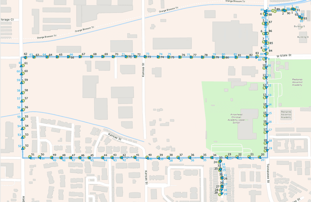
For example, the following image shows a series of GPS points that were collected while driving a vehicle. The result shows the points snapped to the underlying roads and the roads that were traversed.

Parameters
| Name | Required | Type | Default | Description |
|---|---|---|---|---|
f | string | The request response format, either | ||
token | string | An access token with the required privileges. | ||
points | feature | Points that you want to snap to the road. | ||
travel_mode | object | The mode of transportation for the analysis provided as a JSON object. | ||
return_lines | boolean |
| Whether the request will return output_lines representing the roads traversed. | |
road_properties_on_snapped_points | [string] | Road properties returned on the output_snapped_points output. | ||
road_properties_on_lines | [string] | Road properties returned on the output_lines output. | ||
context | object | Additional settings that affect task operation | ||
overrides | string | For internal use only. |
Required parameters
points
Specify the points that you want to snap to the road the vehicle is most likely traveling along. The points can be the GPS points from a navigation device, the tracks captured using ArcGIS Field Maps, or some other set of points that were collected while driving the vehicle.
The distance between the points will affect the performance and final quality of the output. If the points are close together, the algorithm will have a better chance of deducing the probable roads at the expense of processing time. Fewer points will process faster, but may result in the route that was deduced potentially taking different roads.
Show attributes for points
Attributes for points
-
ObjectIDIntegernullable
The ID of the feature. This field is used to link the
outputwith the input points._snapped _points This field will be used to sequence the points if the location_timestamp field is not present.
-
location_timestampdatetimenullable
The date and time at which the point was collected. This is the same as the Time field in a GPX file.
This field will be used to sequence the points if it is available.
-
horizontal_accuracynumber (non-negative)nullable
The horizontal accuracy of the point measured in meters. This is the same as the HDOP field in a GPX file.
-
speednumber (non-negative)nullable
The speed of the point in meters per second.
-
coursenumber (non-negative)nullable
The compass direction of the point in units of 0 to 360 degrees. 0 is due North, 90 is due East and so on.
-
track_idstringnullable
The ID of the track that the point belongs to. This attribute is used to group points that belong to the same track. You can snap multiple tracks in a single request by assigning unique track IDs to points that belong to different tracks.
If this field is not present, the algorithm will assume that all points belong to the same track. If
trackis specified for some points and not for others, the ones without a_id trackwill be unlocated._id
Example:
{
"geometryType": "esriGeometryPoint",
"spatialReference": {
"wkid": 4326,
"latestWkid": 4326
},
"fields": [
{
"name": "OBJECTID",
"type": "esriFieldTypeOID",
"alias": "OBJECTID"
},
{
"name": "location_timestamp",
"type": "esriFieldTypeDate",
"alias": "location_timestamp",
"length": 8
},
{
"name": "track_id",
token
An access token
- ArcGIS Location Platform: premium:user:networkanalysis:snaptoroads
- ArcGIS Online: premium:user:networkanalysis
token=<ACCESS_TOKEN>To use HTTP headers instead of the token parameter, set the following:
GET <SERVICE_REQUEST> HTTP/1.1
Host: <SERVICE_DOMAIN>
X-Esri-Authorization: Bearer <ACCESS_TOKEN>Learn more about access tokens and privileges in the Security and authentication developer guide.
Optional parameters
travel_mode
Choose the mode of transportation for the analysis. This is the mode of transportation that matches the track data you are analyzing.
The snap to roads algorithms use the travel mode settings when determining the most likely roads that were traveled. For example, if the travel mode restricts travel on express lanes, the algorithms attempt to return roads that are not express lanes. However, in cases where the track clearly indicates the use of an express lane, the algorithms return the express lane regardless of the restriction setting. In other words, the travel mode settings are used as a guideline to influence the snapping behavior, but they may be overridden when the track data does not match those settings.
To learn more about travel modes, see Configure travel modes
return_lines
Specify whether or not the request will return output representing the roads traversed.
true—The output_lines will be returned.false—The output_lines will not be returned.
road_properties_on_snapped_points
Allowed values:
oid: The ObjectID of the road segment the snapped points locate on. It is a unique identifier for the road segment._Routing _Streets
posted: The posted speed limit (in kilometers per hour) of the road segment on which the snapped points are located._speed _limit _kph posted: The posted speed limit (in miles per hour) of the road segment on which the snapped points are located._speed _limit _mph posted: The posted speed limit (in meters per second) of the road segment on which the snapped points are located._speed _limit _mps posted: The posted truck speed limit (in kilometers per hour) of the road segment on which the snapped points are located._truck _speed _limit _kph posted: The posted truck speed limit (in miles per hour) of the road segment on which the snapped points are located._truck _speed _limit _mph posted: The posted truck speed limit (in meters per second) of the road segment on which the snapped points are located._truck _speed _limit _mps
Specify the road properties that the request should return on the output output.
For example: road
road_properties_on_lines
Allowed values:
oid: The ObjectID of the road segment. It is a unique identifier for the road segment._Routing _Streets
length: The length (in kilometers) of the road segment._kilometers length: The length (in miles) of the road segment._miles posted: The posted speed limit (in kilometers per hour) of the road segment._speed _limit _kph posted: The posted speed limit (in miles per hour) of the road segment._speed _limit _mph posted: The posted speed limit (in meters per second) of the road segment._speed _limit _mps posted: The posted truck speed limit (in kilometers per hour) of the road segment._truck _speed _limit _kph posted: The posted truck speed limit (in miles per hour) of the road segment._truck _speed _limit _mph posted: The posted truck speed limit (in meters per second) of the road segment._truck _speed _limit _mps
Specify the road properties that the request should return on the output output.
For example: road
analysis_region
Allowed values: Europe, Japan, Korea, Middle, North, South, South, Thailand
Specify the region in which to perform the analysis. If a value is not specified for this parameter, the request will automatically calculate the region name based on the location of the input points. Setting the name of the region is recommended to speed up the analysis.
The data coverage page lists the countries that are grouped into each of these regions.
context
This parameter contains additional settings that affect task operation, for example, the spatial reference of the output features.
Response objects
output_snapped_points
This output is always returned. It includes all of the fields from the input specified in the points parameter plus any fields for the properties specified in the road parameter. The output also contains following attributes that are either generated or altered by the request.
Show attributes for output snapped points
-
ObjectIDinteger
The ID of the feature. This field has the same values as the input
pointsif the ObjectID field was passed in. Otherwise, they are sequential numbers starting with 1 and going up through the number of features returned. -
confidencedouble
This field defines the confidence level of the computed solution - how likely it is that the computed snapped location is accurate. Its value is between 0 and 1 where 0 means it didn't snap to a road at all and 1 is very confident that the snapping is correct.
-
point_typestring enum
The type of the output point. The possible values are as following:
Snapped: The output point is snapped to a road. The confidence field indicates the confidence level of the snapping result.Offroad: The output point is not snapped to any road. This occurs if the input point is too far from a road, the service cannot find a suitable match, or the surrounding points are identified as off-road, in which case the service maintains track consistency by also marking the current point as off-road.Noise: The output point is identified as noise. This occurs when the point belongs to a cluster; in such cases, middle points are flagged as noise and removed to improve snapping accuracy. Additionally, a point is treated as noise if it is a duplicate of the previous point or part of a sequence of zero-speed points, where only the initial point is retained.Outlier: The output point is identified as an outlier. This occurs when the input point is too far from the rest of the track; the service classifies it as an outlier to maintain track consistency.
-
line_idinteger
The ObjectID of the line feature in the
output. This field is only present if_lines returnis specified as_lines truein the input. This field is used to link the output snapped points with the output lines.
output_lines
This output is returned if return is specified as true in the input. It includes fields for the properties specified in the road parameter. The output also contains following attributes that are generated by the request.
Show attributes for output lines
-
ObjectIDinteger
The ID of the feature.
-
track_idstringnullable
The ID of the track that the line belongs to. This attribute is used to group lines that belong to the same track. This attribute is only applicable if the input
pointsspecifytrackattribute._id -
line_typestring enum
The type of the output line. The possible values are as following:
Road: The output line represents a road segment.Off: The output line represents a segment that is not a road or is not known to the routing data. The offroad segments uses straight line to connect the last point before the offroad segment and the first point after the offroad segment, and all the intermediate points are not snapped.Road Gap: The output line represents a gap between two part of the tracks. This can happen when the tracks are not continuous, typically when the GPS signal is lost. The gap is represented by a straight line between the last point before the gap and the first point after the gap.
usage_cost
This parameter returns the credits used by the analysis.
Examples
To use the snap to roads request, you need to pass in a set of point features to which you want to snap to roads. In addition to the point geometry, you can include additional GPS-related data to better guide the snapping. You can also specify if you want to return attributes from the underlying roads and if you want to add them on the output points or lines returned.
Below is an example of a request to the Snap to Roads request and a few sample responses:
POST https://route-api.arcgis.com/arcgis/rest/services/World/SnapToRoadsSync/GPServer/SnapToRoads/execute HTTP/1.1
Content-Type: application/x-www-form-urlencoded
token=<ACCESS_TOKEN>
&f=json
&points={
"features": [
{
"attributes": {
"OBJECTID": 1,
"location_timestamp": 1704522159000
},
"geometry": {
"x": -122.43410099956145,
"y": 37.800155000053394
}
},
{
"attributes": {
"OBJECTID": 2,
Service limits
The table below lists the limits that apply to this request.
| Limit description | Limit value |
|---|---|
The maximum number of input points | 5,000 |
Maximum geodesic distance | 500 miles (804.67 kilometers) |
Maximum straight-line distance for the walking travel mode (If the straight-line distance between any input points is greater than this limit, the analysis fails when the walking restriction is used.) | 27 miles (43.45 kilometers) |
Maximum execution time (If the limit is exceeded, the request fails and returns a 504 gateway timeout error) | 5 minutes |