Find dynamic entities from a data source that match a query.
Use case
Developers can query a DynamicEntityDataSource to find dynamic entities that meet spatial and/or
attribute criteria. The query returns a collection of dynamic entities matching the
DynamicEntityQueryParameters or track IDs at the moment the query is executed.
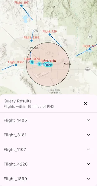
An example of this is a flight tracking app that monitors airspace near a particular airport, allowing the user to monitor flights based on different criteria such as arrival airport or flight number.
How to use the sample
Tap the “Query Flights” button and select a query to perform from the menu. Once the query is complete, a list of the resulting flights will be displayed. Tap on a flight to see its latest attributes in real-time.
How it works
- Create a
DynamicEntityDataSourceto stream dynamic entity events. - Create
DynamicEntityQueryParametersand set its properties:- To spatially filter results, set
geometryandspatialRelationship. - To query entities with certain attribute values, set
whereClause. - To get entities with specific track IDs, modify the trackIDs collection.
- To spatially filter results, set
- To perform a dynamic entities query, call
DynamicEntityDataSource.queryDynamicEntitiesto query with spatial and/or attribute filters, or callDynamicEntityDataSource.queryDynamicEntitiesByTrackIdsif you want to query only by track IDs. - When complete, get the dynamic entities from the result using
DynamicEntityQueryResult.iterator(). - Use
DynamicEntity.onDynamicEntityChangedto receive change notifications. - Get the new observation from
DynamicEntityChangedInfo.receivedObservationand usedynamicEntityPurgedto determine whether a dynamic entity has been purged.
Relevant API
- DynamicEntity
- DynamicEntityChangedInfo
- DynamicEntityDataSource
- DynamicEntityLayer
- DynamicEntityObservation
- DynamicEntityQueryParameters
- DynamicEntityQueryResult
About the data
This sample uses the PHX Air Traffic JSON
portal item, which is hosted on ArcGIS Online and downloaded automatically. The file contains JSON
data for mock air traffic around the Phoenix Sky Harbor International Airport in Phoenix, AZ, USA.
The decoded data is used to simulate dynamic entity events through a
CustomDynamicEntityDataSource, which is displayed on the map with a DynamicEntityLayer.
Additional information
A dynamic entities query is performed on the most recent observation of each dynamic entity in the data source at the time the query is executed. As entities change, they may no longer match the original query parameters.
Tags
data, dynamic, entity, live, query, real-time, search, stream, track
Sample code
//// Copyright 2026 Esri//// Licensed under the Apache License, Version 2.0 (the "License");// you may not use this file except in compliance with the License.// You may obtain a copy of the License at////   https://www.apache.org/licenses/LICENSE-2.0//// Unless required by applicable law or agreed to in writing, software// distributed under the License is distributed on an "AS IS" BASIS,// WITHOUT WARRANTIES OR CONDITIONS OF ANY KIND, either express or implied.// See the License for the specific language governing permissions and// limitations under the License.//
import 'dart:async';import 'dart:convert';import 'dart:io';
import 'package:arcgis_maps/arcgis_maps.dart';import 'package:arcgis_maps_sdk_flutter_samples/common/common.dart';import 'package:flutter/material.dart';import 'package:go_router/go_router.dart';
class QueryDynamicEntities extends StatefulWidget {  const QueryDynamicEntities({super.key});
  @override  State<QueryDynamicEntities> createState() => _QueryDynamicEntitiesState();}
class _QueryDynamicEntitiesState extends State<QueryDynamicEntities>    with SampleStateSupport {  // Create a controller for the map view.  final _mapViewController = ArcGISMapView.createController();
  // Graphics overlay for displaying the PHX airport buffer graphic.  final _bufferGraphicsOverlay = GraphicsOverlay();
  // The dynamic entity layer displayed on the map.  late final DynamicEntityLayer _dynamicEntityLayer;
  // The custom data source streaming mock air traffic observations.  CustomDynamicEntityDataSource? _dataSource;
  // A geometry representing a 15 mile buffer around Phoenix Sky Harbor (PHX).  late final Polygon _phoenixAirportBuffer;
  // A flag for when the map view is ready and controls can be used.  var _ready = false;
  // State for the non-modal query results sheet.  var _isResultsSheetVisible = false;  QuerySelection? _currentSelection;  List<DynamicEntity> _currentEntities = const [];
  @override  void dispose() {    unawaited(_dataSource?.disconnect());    super.dispose();  }
  @override  Widget build(BuildContext context) {    return Scaffold(      body: SafeArea(        top: false,        left: false,        right: false,        child: Stack(          children: [            Column(              children: [                Expanded(                  // Add a map view to the widget tree and set a controller.                  child: ArcGISMapView(                    controllerProvider: () => _mapViewController,                    onMapViewReady: onMapViewReady,                  ),                ),                Row(                  mainAxisAlignment: MainAxisAlignment.spaceEvenly,                  children: [                    // Button to toggle overview or full model sublayers.                    ElevatedButton(                      onPressed: _showQueryMenu,                      child: const Text('Query Flights'),                    ),                  ],                ),              ],            ),            // Display a progress indicator and prevent interaction until state is ready.            LoadingIndicator(visible: !_ready),          ],        ),      ),      bottomSheet: _isResultsSheetVisible          ? _QueryResultsSheet(              selection: _currentSelection!,              entities: _currentEntities,              onClose: _closeResultsSheet,            )          : null,    );  }
  Future<void> onMapViewReady() async {    // Create a map with a topographic basemap and an initial viewpoint.    final map = ArcGISMap.withBasemapStyle(BasemapStyle.arcGISTopographic)      ..initialViewpoint = Viewpoint.withLatLongScale(        latitude: 33.4352,        longitude: -112.0101,        scale: 1266500,      );
    // Create a 15-mile geodetic buffer around Phoenix airport.    final phxPoint = ArcGISPoint(      x: -112.0101,      y: 33.4352,      spatialReference: SpatialReference.wgs84,    );    _phoenixAirportBuffer = GeometryEngine.bufferGeodetic(      geometry: phxPoint,      distance: 15,      distanceUnit: LinearUnit(unitId: LinearUnitId.miles),      maxDeviation: double.nan,      curveType: GeodeticCurveType.geodesic,    );
    // Configure a graphics overlay to display the buffer polygon.    _configureBufferOverlay();    _mapViewController.graphicsOverlays.add(_bufferGraphicsOverlay);
    // Load and configure the dynamic entity layer.    _loadDynamicEntityLayer();    _configureDynamicEntityLayer(_dynamicEntityLayer);    map.operationalLayers.add(_dynamicEntityLayer);
    // Set the map to the map view.    _mapViewController.arcGISMap = map;
    // Set the ready state variable to true to enable the sample UI.    setState(() => _ready = true);  }
  // Configure the graphics overlay to display the PHX airport buffer.  void _configureBufferOverlay() {    final blackLineSymbol = SimpleLineSymbol(color: Colors.black);    final fillSymbol = SimpleFillSymbol(      color: Colors.red.withValues(alpha: 0.1),      outline: blackLineSymbol,    );    final bufferGraphic = Graphic(      geometry: _phoenixAirportBuffer,      symbol: fillSymbol,    );
    _bufferGraphicsOverlay.graphics.clear();    _bufferGraphicsOverlay.graphics.add(bufferGraphic);    _bufferGraphicsOverlay.isVisible = false;  }
  // Load the dynamic entity layer with a custom data source.  void _loadDynamicEntityLayer() {    final listPaths = GoRouter.of(context).state.extra! as List<String>;
    // Create a custom data source that streams PHX air traffic observations.    final provider = _PhxAirTrafficProvider(localJsonPath: listPaths.first);    _dataSource = CustomDynamicEntityDataSource(provider);
    // Create a dynamic entity later from the custom data source.    _dynamicEntityLayer = DynamicEntityLayer(_dataSource!);  }
  // Configure the dynamic entity layer to show track lines and labels.  void _configureDynamicEntityLayer(DynamicEntityLayer layer) {    layer.trackDisplayProperties      ..showPreviousObservations = true      ..showTrackLine = true      ..maximumObservations = 20;
    // Keep default renderers; only configure labels.    final labelDefinition = LabelDefinition(      labelExpression: SimpleLabelExpression(        simpleExpression: '[flight_number]',      ),      textSymbol: TextSymbol(color: Colors.red, size: 12),    )..placement = LabelingPlacement.pointAboveCenter;
    layer.labelDefinitions.add(labelDefinition);    layer.labelsEnabled = true;  }
  // Show a menu for selecting the type of query to perform.  Future<void> _showQueryMenu() async {    final selected = await showModalBottomSheet<QuerySelection>(      context: context,      builder: (context) => SafeArea(        top: false,        child: Column(          mainAxisSize: MainAxisSize.min,          children: [            ListTile(              leading: const Icon(Icons.my_location),              title: const Text('Within 15 Miles of PHX'),              onTap: () => Navigator.pop(context, (                type: QueryType.geometry,                trackId: null,              )),            ),            ListTile(              leading: const Icon(Icons.flight_land),              title: const Text('Arriving in PHX'),              onTap: () => Navigator.pop(context, (                type: QueryType.attributes,                trackId: null,              )),            ),            ListTile(              leading: const Icon(Icons.tag),              title: const Text('With Flight Number'),              onTap: () async {                final navigator = Navigator.of(context);                final flightNumber = await _promptForFlightNumber();                if (flightNumber == null || flightNumber.trim().isEmpty) {                  return;                }                navigator.pop((                  type: QueryType.trackId,                  trackId: flightNumber.trim(),                ));              },            ),          ],        ),      ),    );
    // If a selection was made, run the corresponding query.    if (selected == null) return;    await _runQuery(selected);  }
  // Prompt the user to enter a flight number for the track ID query.  Future<String?> _promptForFlightNumber() async {    final controller = TextEditingController();    return showDialog<String>(      context: context,      builder: (context) {        return AlertDialog(          title: const Text('Enter a Flight Number to Query'),          content: TextField(            controller: controller,            decoration: const InputDecoration(labelText: 'Flight Number'),            autofocus: true,          ),          actions: [            TextButton(              onPressed: () => Navigator.pop(context),              child: const Text('Cancel'),            ),            FilledButton(              onPressed: () => Navigator.pop(context, controller.text),              child: const Text('Done'),            ),          ],        );      },    );  }
  // Run the selected query and display the results in a bottom sheet.  Future<void> _runQuery(QuerySelection selection) async {    final dataSource = _dataSource;    if (dataSource == null) return;    // Show the buffer graphic only for geometry queries.    _bufferGraphicsOverlay.isVisible = selection.type == QueryType.geometry;
    // The result of the dynamic entity query.    DynamicEntityQueryResult queryResult;
    // Execute the appropriate query based on the selection.    switch (selection.type) {      case QueryType.geometry:        final params = DynamicEntityQueryParameters()          ..geometry = _phoenixAirportBuffer          ..spatialRelationship = SpatialRelationship.intersects;        queryResult = await dataSource.queryDynamicEntities(params);      case QueryType.attributes:        final params = DynamicEntityQueryParameters()          ..whereClause = "status = 'In flight' AND arrival_airport = 'PHX'";        queryResult = await dataSource.queryDynamicEntities(params);      case QueryType.trackId:        queryResult = await dataSource.queryDynamicEntitiesByTrackIds([          selection.trackId!,        ]);    }
    // Collect the query results into a list.    final entities = queryResult.dynamicEntities().toList(growable: false);    _dynamicEntityLayer.clearSelection();    if (entities.isNotEmpty) {      _dynamicEntityLayer.selectDynamicEntities(entities);    }
    // Show the query results in a bottom sheet.    _showQueryResultsSheet(selection, entities: entities);  }
  void _showQueryResultsSheet(    QuerySelection selection, {    required List<DynamicEntity> entities,  }) {    setState(() {      _currentSelection = selection;      _currentEntities = entities;      _isResultsSheetVisible = true;    });  }
  void _closeResultsSheet() {    setState(() {      _isResultsSheetVisible = false;      _currentSelection = null;      _currentEntities = const [];    });
    // Clear selection and hide buffer when the results sheet is closed.    _dynamicEntityLayer.clearSelection();    _bufferGraphicsOverlay.isVisible = false;  }}
// Enum representing the types of queries available.enum QueryType { geometry, attributes, trackId }
typedef QuerySelection = ({QueryType type, String? trackId});
// Create a result label based on the query selection.String _resultLabel(QuerySelection selection) {  return switch (selection.type) {    QueryType.geometry => 'Flights within 15 miles of PHX',    QueryType.attributes => 'Flights arriving in PHX',    QueryType.trackId => 'Flights matching number: ${selection.trackId ?? ''}',  };}
class _DynamicEntityObservationTile extends StatefulWidget {  const _DynamicEntityObservationTile({required this.entity});
  // The dynamic entity to observe.  final DynamicEntity entity;
  @override  State<_DynamicEntityObservationTile> createState() =>      _DynamicEntityObservationTileState();}
class _DynamicEntityObservationTileState    extends State<_DynamicEntityObservationTile> {  // Subscribe to the ArcGIS dynamic entity change stream.  StreamSubscription<DynamicEntityChangedInfo>? _subscription;  // Latest observation attributes pulled from the ArcGIS entity.  Map<CaseInsensitiveString, dynamic> _attributes = const {};  // Tracks whether the tile is expanded to show attributes.  bool _isExpanded = false;
  @override  void initState() {    super.initState();    // Seed the attributes with the latest observation, if any.    // Uses the ArcGIS API to read the entity's most recent observation.    _attributes = widget.entity.getLatestObservation()?.attributes ?? const {};
    // Listen for dynamic entity changes to keep the UI in sync.    _subscription = widget.entity.onDynamicEntityChanged.listen((changedInfo) {      if (changedInfo.dynamicEntityPurged) {        // Clear attributes when the entity is purged from the stream.        setState(() => _attributes = const {});        return;      }      final attrs = changedInfo.receivedObservation?.attributes;      if (attrs != null) {        // Update attributes when a new observation arrives.        setState(() => _attributes = attrs);      }    });  }
  @override  void dispose() {    // Cancel the subscription to avoid memory leaks.    _subscription?.cancel();    _subscription = null;    super.dispose();  }
  @override  Widget build(BuildContext context) {    // The flight number as the tile title when available.    final flightNumber = _attributes['flight_number'] as String?;    // Sort attributes to keep the list stable and readable.    final sortedEntries = _attributes.entries.toList()      ..sort((a, b) => a.key.compareTo(b.key));
    return ExpansionTile(      title: Text(flightNumber ?? ''),      initiallyExpanded: _isExpanded,      onExpansionChanged: (expanded) => setState(() => _isExpanded = expanded),      children: sortedEntries          // Filter out null values and render the remaining attributes.          .where((e) => e.value != null)          .map(            (e) => ListTile(              dense: true,              title: Text(_planeAttributeLabel(e.key)),              trailing: Text(_formatAttributeValue(e.value)),            ),          )          .toList(),    );  }
  // Map attribute keys to labels.  static String _planeAttributeLabel(String key) {    switch (key) {      case 'aircraft':        return 'Aircraft';      case 'altitude_feet':        return 'Altitude (ft)';      case 'arrival_airport':        return 'Arrival Airport';      case 'flight_number':        return 'Flight Number';      case 'heading':        return 'Heading';      case 'speed':        return 'Speed';      case 'status':        return 'Status';      default:        return key;    }  }
  // Format attribute values for display.  static String _formatAttributeValue(Object? value) {    if (value == null) return '';    if (value is String) return value;    if (value is num) return value.toStringAsFixed(2);    return value.toString();  }}
class _QueryResultsSheet extends StatelessWidget {  const _QueryResultsSheet({    required this.selection,    required this.entities,    required this.onClose,  });
  // The query selection that produced the results.  final QuerySelection selection;  // The list of dynamic entities returned by the query.  final List<DynamicEntity> entities;  // Callback to close the results sheet.  final VoidCallback onClose;
  @override  Widget build(BuildContext context) {    return SafeArea(      top: false,      child: DraggableScrollableSheet(        expand: false,        initialChildSize: 0.4,        builder: (context, scrollController) {          return Material(            clipBehavior: Clip.antiAlias,            shape: RoundedRectangleBorder(              borderRadius: BorderRadius.circular(16),            ),            child: Column(              children: [                ListTile(                  title: const Text('Query Results'),                  subtitle: Text(_resultLabel(selection)),                  trailing: IconButton(                    icon: const Icon(Icons.close),                    onPressed: onClose,                  ),                ),                const Divider(height: 1),                Expanded(                  child: Builder(                    builder: (context) {                      // Empty state when no entities matched the query.                      if (entities.isEmpty) {                        return const Center(                          child: Padding(                            padding: EdgeInsets.all(16),                            child: Text(                              'There are no flights to display for this query.',                              textAlign: TextAlign.center,                            ),                          ),                        );                      }
                      // A scrollable list of dynamic entity observations.                      return ListView.builder(                        controller: scrollController,                        itemCount: entities.length,                        itemBuilder: (context, index) {                          return _DynamicEntityObservationTile(                            entity: entities[index],                          );                        },                      );                    },                  ),                ),              ],            ),          );        },      ),    );  }}
// Enum representing the keys for plane attributes.enum _PlaneAttributeKey {  aircraft,  altitudeFeet,  arrivalAirport,  flightNumber,  heading,  speed,  status;
  // Provide the field name associated with the attribute key.  String get fieldName {    return switch (this) {      _PlaneAttributeKey.aircraft => 'aircraft',      _PlaneAttributeKey.altitudeFeet => 'altitude_feet',      _PlaneAttributeKey.arrivalAirport => 'arrival_airport',      _PlaneAttributeKey.flightNumber => 'flight_number',      _PlaneAttributeKey.heading => 'heading',      _PlaneAttributeKey.speed => 'speed',      _PlaneAttributeKey.status => 'status',    };  }
  // Determine the field type based on the attribute key.  FieldType get fieldType {    return switch (this) {      _PlaneAttributeKey.heading ||      _PlaneAttributeKey.altitudeFeet ||      _PlaneAttributeKey.speed => FieldType.float64,      _ => FieldType.text,    };  }}
// A custom dynamic entity data provider that streams mock air traffic data for PHX.final class _PhxAirTrafficProvider extends CustomDynamicEntityDataProvider {  // Constructor accepting the local JSON file path.  _PhxAirTrafficProvider({required this.localJsonPath});
  // The local path to the JSON file containing mock air traffic observations.  final String localJsonPath;
  // A flag indicating whether the provider is currently connected.  bool _isConnected = false;
  @override  Future<DynamicEntityDataSourceInfo> onLoad() async {    // Define the fields for the dynamic entity data source.    final fields = _PlaneAttributeKey.values        .map(          (k) => Field(            type: k.fieldType,            name: k.fieldName,            alias: '',            length: 0,            isEditable: false,            isNullable: true,          ),        )        .toList(growable: false);
    // Define the data source info with fields and entity ID field.    final info = DynamicEntityDataSourceInfo(      entityIdFieldName: 'flight_number',      fields: fields,    )..spatialReference = SpatialReference.wgs84;
    return info;  }
  @override  Future<void> onConnect() async {    if (_isConnected) return;    _isConnected = true;
    // Start streaming mock air traffic observations.    unawaited(_startStreaming());  }
  @override  Future<void> onDisconnect() async {    if (!_isConnected) return;    _isConnected = false;  }
  // Start streaming mock air traffic observations from the local JSON file.  Future<void> _startStreaming() async {    final file = File(localJsonPath);
    // Decodes the plane from the line and uses it to create a new observation.    final lines = file        .openRead()        .transform(utf8.decoder)        .transform(const LineSplitter());
    // Stream each line as a new observation until disconnected.    await for (final line in lines) {      if (!_isConnected) return;
      final decoded = jsonDecode(line) as Map<String, dynamic>;      final geometryJson = decoded['geometry'] as Map<String, dynamic>?;      final attributesJson = decoded['attributes'] as Map<String, dynamic>?;
      final geometry = Geometry.fromJson(geometryJson!);      handleEntityDataEvent(NewObservation(geometry, attributesJson!));
      // Delay the next observation to simulate live data.      await Future<void>.delayed(const Duration(milliseconds: 100));    }  }}