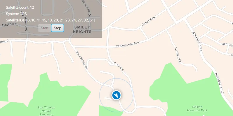
Parse NMEA sentences and use the results to show device location on the map.
Use case
NMEA sentences can be retrieved from GPS receivers and parsed into a series of coordinates with additional information. Devices without a built-in GPS receiver can retrieve NMEA sentences by using a separate GPS dongle, commonly connected via bluetooth or through a serial port.
The NMEA location data source allows for detailed interrogation of the information coming from the GPS receiver. For example, allowing you to report the number of satellites in view.
How to use the sample
Click “Start” to parse the provided NMEA sentences into a location data source, and display the location position and related satellite information. Click “Stop” to stop displaying the location information. The sample will automatically re-center the location data source as it moves across the map.
How it works
- Load NMEA sentences from a local file.
- Parse the NMEA sentence strings, and push data into
NmeaLocationDataSource. - Set the
NmeaLocationDataSourceto theLocationDisplay’s data source. - Start the location display to begin receiving location and satellite updates.
Relevant API
- LocationDisplay
- NmeaLocationDataSource
- NmeaSatelliteInfo
About the data
This sample reads lines from a local file to simulate the feed of data into the NmeaLocationDataSource. This simulated data source provides NMEA data periodically, and allows the sample to be used on devices without a GPS dongle that produces NMEA data.
The route taken in this sample features a one minute driving trip around Redlands, CA.
Additional information
To learn more about using the ArcGIS Maps SDK for Java for retrieving NMEA sentences from a GPS dongle, see the Esri Community blog post Adding GPS data to your ArcGIS Runtime API for Java App.
Tags
GPS, history, navigation, NMEA, real-time, trace
Sample code
/* * Copyright 2021 Esri * * Licensed under the Apache License, Version 2.0 (the "License"); * you may not use this file except in compliance with the License. * You may obtain a copy of the License at * *    http://www.apache.org/licenses/LICENSE-2.0 * * Unless required by applicable law or agreed to in writing, software * distributed under the License is distributed on an "AS IS" BASIS, * WITHOUT WARRANTIES OR CONDITIONS OF ANY KIND, either express or implied. * See the License for the specific language governing permissions and * limitations under the License. * */
package com.esri.samples.display_device_location_with_nmea_data_sources;
import java.io.BufferedReader;import java.io.File;import java.io.FileReader;import java.nio.charset.StandardCharsets;import java.util.ArrayList;import java.util.Collections;import java.util.HashSet;import java.util.List;import java.util.stream.Collectors;
import javafx.animation.KeyFrame;import javafx.animation.Timeline;import javafx.fxml.FXML;import javafx.scene.control.Alert;import javafx.scene.control.Button;import javafx.scene.control.Label;import javafx.util.Duration;
import com.esri.arcgisruntime.ArcGISRuntimeEnvironment;import com.esri.arcgisruntime.geometry.Point;import com.esri.arcgisruntime.geometry.SpatialReferences;import com.esri.arcgisruntime.location.LocationDataSource;import com.esri.arcgisruntime.location.NmeaLocationDataSource;import com.esri.arcgisruntime.location.NmeaSatelliteInfo;import com.esri.arcgisruntime.mapping.ArcGISMap;import com.esri.arcgisruntime.mapping.BasemapStyle;import com.esri.arcgisruntime.mapping.Viewpoint;import com.esri.arcgisruntime.mapping.view.LocationDisplay;import com.esri.arcgisruntime.mapping.view.MapView;
public class DisplayDeviceLocationWithNmeaDataSourcesController {
  @FXML private MapView mapView;  @FXML private Label satelliteCount;  @FXML private Label satelliteID;  @FXML private Button startButton;  @FXML private Button stopButton;  @FXML private Label systemInfo;
  private int count = 0;  private NmeaLocationDataSource nmeaLocationDataSource;  private List<NmeaSatelliteInfo> nmeaSatelliteInfo;
  public void initialize() {
    try {
      // authentication with an API key or named user is required to access basemaps and other location services      String yourAPIKey = System.getProperty("apiKey");      ArcGISRuntimeEnvironment.setApiKey(yourAPIKey);
      // create a map with the navigation basemap style and set it to the map view      ArcGISMap map = new ArcGISMap(BasemapStyle.ARCGIS_NAVIGATION);      mapView.setMap(map);
      // set a viewpoint on the map view centered on Redlands, California      mapView.setViewpoint(new Viewpoint(new Point(-117.191, 34.0306, SpatialReferences.getWgs84()), 100000));
      // create a new NMEA location data source      nmeaLocationDataSource = new NmeaLocationDataSource(SpatialReferences.getWgs84());
      // set the NMEA location data source onto the map view's location display      LocationDisplay locationDisplay = mapView.getLocationDisplay();      locationDisplay.setLocationDataSource(nmeaLocationDataSource);      locationDisplay.setAutoPanMode(LocationDisplay.AutoPanMode.RECENTER);
      // disable map view interaction, the location display will automatically center on the mock device location      mapView.setEnableMousePan(false);      mapView.setEnableKeyboardNavigation(false);      stopButton.setDisable(true);
    } catch (Exception e) {      // on any error, display the stack trace.      e.printStackTrace();    }  }
  /**   * Initializes the location data source, reads the mock data NMEA sentences, and displays location updates from that file   * on the location display. Data is pushed to the data source using a timeline to simulate live updates, as they would   * appear if using real-time data from a GPS dongle.   */  @FXML  private void start() {
    // prepare the mock data NMEA sentences    File simulatedNmeaDataFile = new File(System.getProperty("data.dir"), "./samples-data/redlands/Redlands.nmea");    if (simulatedNmeaDataFile.exists()) {
      try {        // read the nmea file contents using a buffered reader and store the mock data sentences in a list        BufferedReader bufferedReader = new BufferedReader(new FileReader(simulatedNmeaDataFile.getPath()));        // add carriage return for NMEA location data source parser        List<String> nmeaSentences = bufferedReader.lines().map(nmeaSentence -> nmeaSentence + "\n").collect(Collectors.toList());
        // close the stream and release resources        bufferedReader.close();
        LocationDataSource.StatusChangedListener listener = new LocationDataSource.StatusChangedListener() {
          // create a new timeline to simulate a stream of NMEA data          final Timeline timeline = new Timeline();
          @Override          public void statusChanged(LocationDataSource.StatusChangedEvent statusChangedEvent) {            // check that the location data source has started            if (statusChangedEvent.getStatus() == LocationDataSource.Status.STARTED) {
              // add a satellite changed listener to the NMEA location data source and display satellite information on the app              setupSatelliteChangedListener();
              timeline.setCycleCount(-1); // loop count              // push the mock data NMEA sentences into the data source every 250 ms              timeline.getKeyFrames().add(new KeyFrame(Duration.millis(250), event -> {
                // note: you can also use real-time NMEA sentences obtained via a GPS dongle                nmeaLocationDataSource.pushData(nmeaSentences.get(count++).getBytes(StandardCharsets.UTF_8)); // post increment step                // reset the count after the last data point is reached                if (count == nmeaSentences.size()) {                  count = 0;                }
              }));
              // start the timeline              timeline.play();              // handle UI interactions              startButton.setDisable(true);              stopButton.setDisable(false);
              // stop the timeline and remove the status changed listener when the location data source has stopped            } if (statusChangedEvent.getStatus() == LocationDataSource.Status.STOPPED) {
              timeline.stop();              nmeaLocationDataSource.removeStatusChangedListener(this);              // handle UI interactions              stopButton.setDisable(true);              startButton.setDisable(false);
            }          }        };
        // initialize the location data source and prepare to begin receiving location updates when data is pushed. As        // updates are received, they will be displayed on the map        nmeaLocationDataSource.addStatusChangedListener(listener);        nmeaLocationDataSource.startAsync();
      } catch (Exception e) {        new Alert(Alert.AlertType.ERROR, e.getCause().getMessage()).show();        e.printStackTrace();      }
    } else {      new Alert(Alert.AlertType.ERROR, "File not found").show();    }
  }
  /**   * Obtains NMEA satellite information from the NMEA location data source, and displays satellite information on the app.   */  private void setupSatelliteChangedListener() {
    HashSet<Integer> uniqueSatelliteIds = new HashSet<>();
    nmeaLocationDataSource.addSatellitesChangedListener(satellitesChangedEvent -> {
      // get satellite information from the NMEA location data source every time the satellites change      nmeaSatelliteInfo = satellitesChangedEvent.getSatelliteInfos();      // set the text of the satellite count label      satelliteCount.setText("Satellite count: " + nmeaSatelliteInfo.size());
      for (NmeaSatelliteInfo satInfo : nmeaSatelliteInfo) {        // collect unique satellite ids        uniqueSatelliteIds.add(satInfo.getId());        // sort the ids numerically        List<Integer> sortedIds = new ArrayList<>(uniqueSatelliteIds);        Collections.sort(sortedIds);        // display the satellite system and id information        systemInfo.setText("System: " + satInfo.getSystem());        satelliteID.setText("Satellite IDs: " + sortedIds);      }    });  }
  /**   * Stops displaying the mock data location and receiving location data.   */  @FXML  private void stop() {
    // stop receiving and displaying location data    nmeaLocationDataSource.stopAsync();
  }
  /**   * Disposes application resources.   */  void terminate() {    if (mapView != null) {      nmeaLocationDataSource.stopAsync();      mapView.dispose();    }  }
}
/* * Copyright 2021 Esri * * Licensed under the Apache License, Version 2.0 (the "License"); * you may not use this file except in compliance with the License. * You may obtain a copy of the License at * * http://www.apache.org/licenses/LICENSE-2.0 * * Unless required by applicable law or agreed to in writing, software * distributed under the License is distributed on an "AS IS" BASIS, * WITHOUT WARRANTIES OR CONDITIONS OF ANY KIND, either express or implied. * See the License for the specific language governing permissions and * limitations under the License. * */
package com.esri.samples.display_device_location_with_nmea_data_sources;
import java.io.IOException;
import javafx.application.Application;import javafx.fxml.FXMLLoader;import javafx.scene.Parent;import javafx.scene.Scene;import javafx.stage.Stage;
public class DisplayDeviceLocationWithNmeaDataSourcesSample extends Application {
private static DisplayDeviceLocationWithNmeaDataSourcesController controller; @Override public void start(Stage stage) throws IOException { // set up the scene FXMLLoader loader = new FXMLLoader(getClass().getResource("/display_device_location_with_nmea_data_sources/main.fxml")); Parent root = loader.load(); controller = loader.getController(); Scene scene = new Scene(root);
// set up the stage stage.setTitle("Display Device Location with NMEA Data Sources Sample"); stage.setWidth(800); stage.setHeight(700); stage.setScene(scene); stage.show(); }
/** * Stops and releases all resources used in application. */ @Override public void stop() { controller.terminate(); }
/** * Opens and runs application. * * @param args arguments passed to this application */ public static void main(String[] args) {
Application.launch(args); }}