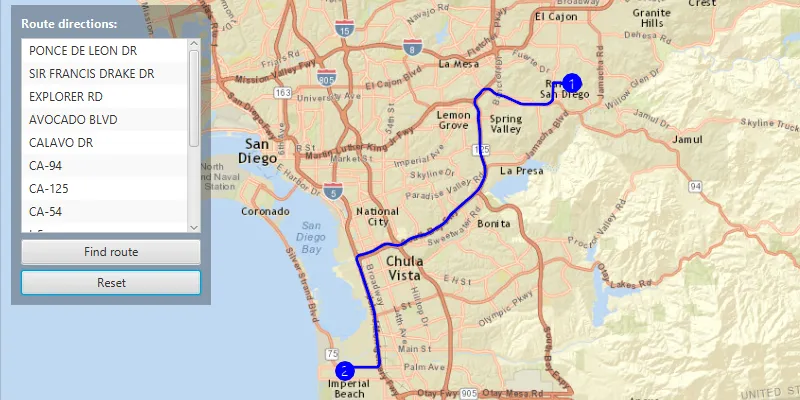
Display directions for a route between two points.
Use case
Find routes with driving directions between any number of locations. You might use the ArcGIS platform to create a custom network for routing on a private roads.
How to use the sample
For simplicity, the sample comes loaded with a start and end stop. You can tap on the “Find Route” button to display a route between these stops. Once the route is generated, turn-by-turn directions are shown in a list. You can use the “Reset” button to reset the sample.
How it works
- Create a
RouteTaskusing a URL to an online route service. - Generate default
RouteParametersusingrouteTask.createDefaultParametersAsync(). - Use
setReturnDirectionson the parameters and set to true. - Use
setStopson the parameters to addStops to its stops collection for each destination. - Solve the route using
routeTask.solveAsync(routeParameters)to get aRouteResult. - Iterate through the result’s
Routes. To display the route, create a graphic using the geometry fromroute.getRouteGeometry(). To display directions, useroute.getDirectionManeuvers(), and for eachDirectionManeuver, displayDirectionManeuver.getDirectionText().
Relevant API
- DirectionManeuver
- Route
- RouteParameters
- RouteResult
- RouteTask
- Stop
Tags
directions, driving, navigation, network, network analysis, route, routing, shortest path, turn-by-turn
Sample code
FindRouteSample.java
/* * Copyright 2017 Esri. * * Licensed under the Apache License, Version 2.0 (the "License"); you may not * use this file except in compliance with the License. You may obtain a copy of * the License at * * http://www.apache.org/licenses/LICENSE-2.0 * * Unless required by applicable law or agreed to in writing, software * distributed under the License is distributed on an "AS IS" BASIS, WITHOUT * WARRANTIES OR CONDITIONS OF ANY KIND, either express or implied. See the * License for the specific language governing permissions and limitations under * the License. */
package com.esri.samples.find_route;
import java.util.ArrayList;import java.util.List;import java.util.Objects;
import javafx.application.Application;import javafx.geometry.Insets;import javafx.geometry.Pos;import javafx.scene.Scene;import javafx.scene.control.Alert;import javafx.scene.control.Button;import javafx.scene.control.Label;import javafx.scene.control.ListView;import javafx.scene.layout.Background;import javafx.scene.layout.BackgroundFill;import javafx.scene.layout.CornerRadii;import javafx.scene.layout.StackPane;import javafx.scene.layout.VBox;import javafx.scene.paint.Color;import javafx.scene.paint.Paint;import javafx.stage.Stage;
import com.esri.arcgisruntime.ArcGISRuntimeEnvironment;import com.esri.arcgisruntime.geometry.Envelope;import com.esri.arcgisruntime.geometry.Geometry;import com.esri.arcgisruntime.geometry.Point;import com.esri.arcgisruntime.geometry.SpatialReference;import com.esri.arcgisruntime.loadable.LoadStatus;import com.esri.arcgisruntime.mapping.ArcGISMap;import com.esri.arcgisruntime.mapping.BasemapStyle;import com.esri.arcgisruntime.mapping.view.Graphic;import com.esri.arcgisruntime.mapping.view.GraphicsOverlay;import com.esri.arcgisruntime.mapping.view.MapView;import com.esri.arcgisruntime.symbology.SimpleLineSymbol;import com.esri.arcgisruntime.symbology.SimpleMarkerSymbol;import com.esri.arcgisruntime.symbology.SimpleMarkerSymbol.Style;import com.esri.arcgisruntime.symbology.TextSymbol;import com.esri.arcgisruntime.symbology.TextSymbol.HorizontalAlignment;import com.esri.arcgisruntime.symbology.TextSymbol.VerticalAlignment;import com.esri.arcgisruntime.tasks.networkanalysis.DirectionManeuver;import com.esri.arcgisruntime.tasks.networkanalysis.Route;import com.esri.arcgisruntime.tasks.networkanalysis.RouteParameters;import com.esri.arcgisruntime.tasks.networkanalysis.RouteResult;import com.esri.arcgisruntime.tasks.networkanalysis.RouteTask;import com.esri.arcgisruntime.tasks.networkanalysis.Stop;
public class FindRouteSample extends Application {
  private MapView mapView;  private RouteTask routeTask;  private RouteParameters routeParameters;  private final ListView<String> directionsList = new ListView<>();
  private Graphic routeGraphic;  private final GraphicsOverlay routeGraphicsOverlay = new GraphicsOverlay();
  private final SpatialReference ESPG_3857 = SpatialReference.create(102100);
  private static final String ROUTE_TASK_SANDIEGO =      "https://sampleserver6.arcgisonline.com/arcgis/rest/services/NetworkAnalysis/SanDiego/NAServer/Route";
  @Override  public void start(Stage stage) {
    try {      // create stack pane and application scene      StackPane stackPane = new StackPane();      Scene scene = new Scene(stackPane);      scene.getStylesheets().add(Objects.requireNonNull(getClass().getResource("/find_route/style.css")).toExternalForm());
      // set title, size, and add scene to stage      stage.setTitle("Find Route Sample");      stage.setWidth(800);      stage.setHeight(700);      stage.setScene(scene);      stage.show();
      // authentication with an API key or named user is required to access basemaps and other location services      String yourAPIKey = System.getProperty("apiKey");      ArcGISRuntimeEnvironment.setApiKey(yourAPIKey);
      // create a control panel      VBox controlsVBox = new VBox(6);      controlsVBox.setBackground(new Background(new BackgroundFill(Paint.valueOf("rgba(0,0,0,0.3)"), CornerRadii.EMPTY,          Insets.EMPTY)));      controlsVBox.setPadding(new Insets(10.0));      controlsVBox.setMaxSize(450, 300);      controlsVBox.getStyleClass().add("panel-region");
      Label directionsLabel = new Label("Route directions:");      directionsLabel.getStyleClass().add("panel-label");
      // create buttons for user interaction      Button findButton = new Button("Find route");      findButton.setMaxWidth(Double.MAX_VALUE);      findButton.setDisable(true);      Button resetButton = new Button("Reset");      resetButton.setMaxWidth(Double.MAX_VALUE);      resetButton.setDisable(true);
      // find route      findButton.setOnAction(e -> {        try {          RouteResult result = routeTask.solveRouteAsync(routeParameters).get();          List<Route> routes = result.getRoutes();          if (routes.size() < 1) {            directionsList.getItems().add("No Routes");          }          Route route = routes.get(0);          Geometry shape = route.getRouteGeometry();
          routeGraphic = new Graphic(shape, new SimpleLineSymbol(SimpleLineSymbol.Style.SOLID, Color.BLUE, 2));          routeGraphicsOverlay.getGraphics().add(routeGraphic);
          // get the direction text for each maneuver          for (DirectionManeuver step : route.getDirectionManeuvers()) {            directionsList.getItems().add(step.getDirectionText());          }
          resetButton.setDisable(false);          findButton.setDisable(true);
        } catch (Exception ex) {          ex.printStackTrace();        }      });
      // clear the route and the directions maneuver found      resetButton.setOnAction(e -> {        routeGraphicsOverlay.getGraphics().remove(routeGraphic);        directionsList.getItems().clear();        resetButton.setDisable(true);        findButton.setDisable(false);      });
      // add buttons and direction list and label to the control panel      controlsVBox.getChildren().addAll(directionsLabel, directionsList, findButton, resetButton);
      // create a map with the streets basemap style      ArcGISMap map = new ArcGISMap(BasemapStyle.ARCGIS_STREETS);
      // create a map view and set the map to it      mapView = new MapView();      mapView.setMap(map);
      // set the viewpoint to San Diego (U.S.)      mapView.setViewpointGeometryAsync(new Envelope(-13067866, 3843014, -13004499, 3871296, ESPG_3857));
      // add the graphic overlay to the map view      mapView.getGraphicsOverlays().add(routeGraphicsOverlay);
      try {        // create route task from San Diego service        routeTask = new RouteTask(ROUTE_TASK_SANDIEGO);
        // load route task        routeTask.loadAsync();        routeTask.addDoneLoadingListener(() -> {          if (routeTask.getLoadStatus() == LoadStatus.LOADED) {            try {
              // enable the find route button              findButton.setDisable(false);
              // get default route parameters              routeParameters = routeTask.createDefaultParametersAsync().get();              routeParameters.setOutputSpatialReference(ESPG_3857);
              // set flags to return stops and directions              routeParameters.setReturnStops(true);              routeParameters.setReturnDirections(true);
              // set stop locations              Point stop1Loc = new Point(-1.3018598562659847E7, 3863191.8817135547, ESPG_3857);              Point stop2Loc = new Point(-1.3036911787723785E7, 3839935.706521739, ESPG_3857);
              // add route stops              List<Stop> routeStops = new ArrayList<>();              routeStops.add(new Stop(stop1Loc));              routeStops.add(new Stop(stop2Loc));              routeParameters.setStops(routeStops);
              // add route stops to the stops overlay              SimpleMarkerSymbol stopMarker = new SimpleMarkerSymbol(Style.CIRCLE, Color.BLUE, 14);              routeGraphicsOverlay.getGraphics().add(new Graphic(stop1Loc, stopMarker));              routeGraphicsOverlay.getGraphics().add(new Graphic(stop2Loc, stopMarker));
              // add order text symbols to the stops
              TextSymbol stop1Text = new TextSymbol(10, "1", Color.WHITE, HorizontalAlignment.CENTER, VerticalAlignment.MIDDLE);              TextSymbol stop2Text = new TextSymbol(10, "2", Color.WHITE, HorizontalAlignment.CENTER, VerticalAlignment.MIDDLE);              routeGraphicsOverlay.getGraphics().add(new Graphic(stop1Loc, stop1Text));              routeGraphicsOverlay.getGraphics().add(new Graphic(stop2Loc, stop2Text));
            } catch (Exception ex) {              ex.printStackTrace();            }          } else {            Alert alert = new Alert(Alert.AlertType.ERROR, "Route Task Failed to Load!");            alert.show();          }        });
      } catch (Exception e) {        e.printStackTrace();      }
      // add the map view and control panel to stack pane      stackPane.getChildren().addAll(mapView, controlsVBox);      StackPane.setAlignment(controlsVBox, Pos.TOP_LEFT);      StackPane.setMargin(controlsVBox, new Insets(10, 0, 0, 10));
    } catch (Exception e) {      // on any error, display the stack trace.      e.printStackTrace();    }  }
  /**   * Stops and releases all resources used in application.   */  @Override  public void stop() {
    if (mapView != null) {      mapView.dispose();    }  }
  /**   * Opens and runs application.   *   * @param args arguments passed to this application   */  public static void main(String[] args) {
    Application.launch(args);  }}