A multipart geometry can be densified by adding interpolated points at regular intervals. Generalizing multipart geometry simplifies it while preserving its general shape. Densifying a multipart geometry adds more vertices at regular intervals.
Use case
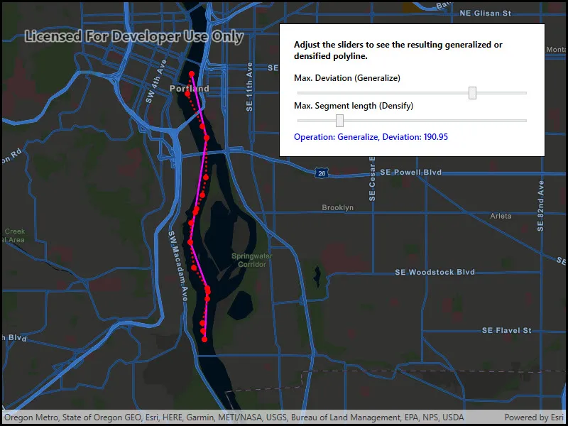
The sample shows a polyline representing a ship’s location at irregular intervals. The density of vertices along the ship’s route is appropriate to represent the path of the ship at the sample map view’s initial scale. However, that level of detail may be too great if you wanted to show a polyline of the ship’s movement down the whole of the Willamette river. Then, you might consider generalizing the polyline to still faithfully represent the ship’s passage on the river without having an overly complicated geometry.
Densifying a multipart geometry can be used to more accurately represent curved lines or to add more regularity to the vertices making up a multipart geometry.
How to use the sample
Use the sliders to control the parameters of the densify and generalize methods.
How it works
- Use the static extension method
polyline.Densify(maxSegmentLength)to densify the polyline object. The resulting polyline object will have more points along the line, so that there are no points greater thanmaxSegmentLengthfrom the next point. - Use the static extension method
polyline.Generalize(maxDeviation, true)to generalize the polyline object. The resulting polyline object will have points shifted from the original line to simplify the shape. None of these points can deviate farther from the original line thanmaxDeviation. The last parameter,removeDegenerateParts, will clean up extraneous parts of a multipart geometry. This will have no effect in this sample as the polyline does not contain extraneous parts. - Note that
maxSegmentLengthandmaxDeviationare in the units of the geometry’s coordinate system. In this example, a cartesian coordinate system is used and at a small enough scale that geodesic distances are not required.
Relevant API
- GeometryEngine
- Multipoint
- Point
- PointCollection
- Polyline
- SimpleLineSymbol
- SpatialReference
Tags
data, densify, generalize, simplify
Sample code
// Copyright 2018 Esri.//// Licensed under the Apache License, Version 2.0 (the "License"); you may not use this file except in compliance with the License.// You may obtain a copy of the License at: http://www.apache.org/licenses/LICENSE-2.0//// Unless required by applicable law or agreed to in writing, software distributed under the License is distributed on an// "AS IS" BASIS, WITHOUT WARRANTIES OR CONDITIONS OF ANY KIND, either express or implied. See the License for the specific// language governing permissions and limitations under the License.
using Esri.ArcGISRuntime.Geometry;using Esri.ArcGISRuntime.Mapping;using Esri.ArcGISRuntime.Symbology;using Esri.ArcGISRuntime.UI;using System.Drawing;using System.Linq;
namespace ArcGIS.WPF.Samples.DensifyAndGeneralize{    [ArcGIS.Samples.Shared.Attributes.Sample(        name: "Densify and generalize",        category: "Geometry",        description: "A multipart geometry can be densified by adding interpolated points at regular intervals. Generalizing multipart geometry simplifies it while preserving its general shape. Densifying a multipart geometry adds more vertices at regular intervals.",        instructions: "Use the sliders to control the parameters of the densify and generalize methods.",        tags: new[] { "data", "densify", "generalize", "simplify" })]    public partial class DensifyAndGeneralize    {        // Graphic used to refer to the original geometry.        private Polyline _originalPolyline;
        // Graphics used to show the densify or generalize result.        private Graphic _resultPolylineGraphic;        private Graphic _resultPointGraphic;
        public DensifyAndGeneralize()        {            InitializeComponent();
            // Create the map with a default basemap.            MyMapView.Map = new Map(BasemapStyle.ArcGISStreetsNight);
            // Create and add a graphics overlay.            GraphicsOverlay overlay = new GraphicsOverlay();            MyMapView.GraphicsOverlays.Add(overlay);
            // Create the original geometry: some points along a river.            PointCollection points = CreateShipPoints();
            // Show the original geometry as red dots on the map.            Multipoint originalMultipoint = new Multipoint(points);            Graphic originalPointsGraphic = new Graphic(originalMultipoint,                new SimpleMarkerSymbol(SimpleMarkerSymbolStyle.Circle, Color.Red, 7));            overlay.Graphics.Add(originalPointsGraphic);
            // Show a dotted red line connecting the original points.            _originalPolyline = new Polyline(points);            Graphic originalPolylineGraphic = new Graphic(_originalPolyline,                new SimpleLineSymbol(SimpleLineSymbolStyle.Dot, Color.Red, 3));            overlay.Graphics.Add(originalPolylineGraphic);
            // Show the result (densified or generalized) points as magenta dots on the map.            _resultPointGraphic = new Graphic            {                Symbol = new SimpleMarkerSymbol(SimpleMarkerSymbolStyle.Circle, Color.Magenta, 7)            };            overlay.Graphics.Add(_resultPointGraphic);
            // Connect the result points with a magenta polyline.            _resultPolylineGraphic = new Graphic            {                Symbol = new SimpleLineSymbol(SimpleLineSymbolStyle.Solid, Color.Magenta, 3)            };            overlay.Graphics.Add(_resultPolylineGraphic);
            // Listen for changes in state.            DeviationSlider.ValueChanged += (o, e) =>                UpdateGeometry("Generalize", SegmentLengthSlider.Value, DeviationSlider.Value);            SegmentLengthSlider.ValueChanged += (o, e) =>                UpdateGeometry("Densify", SegmentLengthSlider.Value, DeviationSlider.Value);
            // Center the map.            MyMapView.SetViewpointGeometryAsync(_originalPolyline.Extent, 100);        }
        private void UpdateGeometry(string operation, double segmentLength, double deviation)        {            // Start with the original polyline.            Polyline polyline = _originalPolyline;
            // Apply the selected operation.            if (operation == "Generalize")            {                // Reset the other slider.                SegmentLengthSlider.Value = 100;
                polyline = (Polyline)polyline.Generalize(deviation, true);
                // Update the result label.                ResultLabel.Text = string.Format("Operation: Generalize, Deviation: {0:f}", deviation);            }            else            {                // Reset the other slider.                DeviationSlider.Value = 10;
                polyline = (Polyline)polyline.Densify(segmentLength);
                // Update the result label.                ResultLabel.Text = string.Format("Operation: Densify, Segment length: {0:f}", segmentLength);            }
            // Update the graphic geometries to show the results.            _resultPolylineGraphic.Geometry = polyline;            _resultPointGraphic.Geometry = new Multipoint(polyline.Parts.SelectMany(m => m.Points));        }
private static PointCollection CreateShipPoints() { return new PointCollection(SpatialReference.Create(32126)) { new MapPoint(2330611.130549, 202360.002957, 0.000000), new MapPoint(2330583.834672, 202525.984012, 0.000000), new MapPoint(2330574.164902, 202691.488009, 0.000000), new MapPoint(2330689.292623, 203170.045888, 0.000000), new MapPoint(2330696.773344, 203317.495798, 0.000000), new MapPoint(2330691.419723, 203380.917080, 0.000000), new MapPoint(2330435.065296, 203816.662457, 0.000000), new MapPoint(2330369.500800, 204329.861789, 0.000000), new MapPoint(2330400.929891, 204712.129673, 0.000000), new MapPoint(2330484.300447, 204927.797132, 0.000000), new MapPoint(2330514.469919, 205000.792463, 0.000000), new MapPoint(2330638.099138, 205271.601116, 0.000000), new MapPoint(2330725.315888, 205631.231308, 0.000000), new MapPoint(2330755.640702, 206433.354860, 0.000000), new MapPoint(2330680.644719, 206660.240923, 0.000000), new MapPoint(2330386.957926, 207340.947204, 0.000000), new MapPoint(2330485.861737, 207742.298501, 0.000000) }; } }}<UserControl x:Class="ArcGIS.WPF.Samples.DensifyAndGeneralize.DensifyAndGeneralize" xmlns="http://schemas.microsoft.com/winfx/2006/xaml/presentation" xmlns:x="http://schemas.microsoft.com/winfx/2006/xaml" xmlns:esri="http://schemas.esri.com/arcgis/runtime/2013"> <Grid> <esri:MapView x:Name="MyMapView" /> <Border Style="{StaticResource BorderStyle}"> <Grid> <Grid.RowDefinitions> <RowDefinition Height="Auto" /> <RowDefinition Height="Auto" /> <RowDefinition Height="Auto" /> <RowDefinition Height="Auto" /> <RowDefinition Height="Auto" /> <RowDefinition Height="Auto" /> </Grid.RowDefinitions> <TextBlock Grid.Row="0" Margin="0,0,0,15" FontWeight="Bold" Text="Adjust the sliders to see the resulting generalized or densified polyline." TextWrapping="Wrap" /> <TextBlock Grid.Row="1" FontWeight="SemiBold" Text="Max. Deviation (Generalize)" /> <Slider x:Name="DeviationSlider" Grid.Row="2" Margin="0,5,0,0" Maximum="250" Minimum="1" Value="10" /> <TextBlock Grid.Row="3" FontWeight="SemiBold" Text="Max. Segment length (Densify)" /> <Slider x:Name="SegmentLengthSlider" Grid.Row="4" Margin="0,5,0,5" Maximum="500" Minimum="100" Value="100" /> <TextBlock x:Name="ResultLabel" Grid.Row="5" FontWeight="SemiBold" Foreground="Blue" Text="Adjust a slider to start" TextWrapping="Wrap" /> </Grid> </Border> </Grid></UserControl>