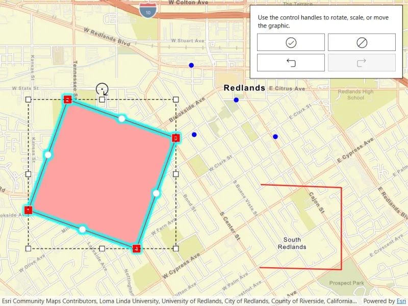
Use the geometry editor to see information about the geometry editor’s previewed geometry during an editing interaction.
Use case
The geometry editor can provide information about the geometry being created or edited during an interaction. This information can be used to give feedback to the user to show the effect of the interaction on the geometry.
How to use the sample
Tap a graphic to edit its geometry by moving, rotating, or scaling the geometry. During the interaction, information about the geometry will be displayed to provide feedback to the user.
Use the buttons in the settings view to undo or redo changes made to the geometry and the cancel and done buttons to discard and save changes, respectively.
How it works
- Create a
GeometryEditorand set it to theMapView.GeometryEditor. - Add an event handler to listen to
GeometryEditor.InteractionPreviewChanged.- This event can be used to get information on the state of the geometry during an interaction with the
GeometryEditorInteractionPreviewparameter.- The
PreviewGeometryrepresents the geometry’s state at that moment. - The
InteractionTypecan be used to determine the type of interaction that is occurring (Create,Move,Rotate,Scale). - The
InteractionElementcan be used to determine the element being interacted with (GeometryEditorVertex,GeometryEditorPart,GeometryEditorGeometry).
- The
- This event can be used to get information on the state of the geometry during an interaction with the
- Start the
GeometryEditorusingGeometryEditor.Start(Geometry)to edit the geometry of an identifiedGraphic.- To identify the
GraphicuseMapView.IdentifyGraphicsOverlayAsync(...)and get the first result.
- To identify the
- Check to see if undo and redo are possible during an editing session using
GeometryEditor.CanUndoandGeometryEditor.CanRedo. If it’s possible, useGeometryEditor.Undo()andGeometryEditor.Redo(). - Call
GeometryEditor.Stop()to finish the editing session and store theGraphic. TheGeometryEditordoes not automatically handle the visualization of a geometry output from an editing session. This must be done manually by propagating the geometry returned into aGraphicadded to aGraphicsOverlay.- To update the geometry underlying an existing
Graphicin theGraphicsOverlay:- Replace the existing
Graphic’sGeometryproperty with the geometry returned by theGeometryEditor.Stop()method.
- Replace the existing
- To update the geometry underlying an existing
Relevant API
- Geometry
- GeometryEditor
- GeometryEditor.InteractionPreviewChanged
- GeometryEditorInteractionPreview
- GeometryEditorInteractionType
- Graphic
- GraphicsOverlay
Additional information
The GeometryEditor.InteractionPreviewChanged event fires continuously during an interaction, therefore it’s not recommended to use it as a trigger for resource intensive actions.
Tags
draw, edit, geometry editor, interaction preview
Sample code
// Copyright 2026 Esri.//// Licensed under the Apache License, Version 2.0 (the "License"); you may not use this file except in compliance with the License.// You may obtain a copy of the License at: http://www.apache.org/licenses/LICENSE-2.0//// Unless required by applicable law or agreed to in writing, software distributed under the License is distributed on an// "AS IS" BASIS, WITHOUT WARRANTIES OR CONDITIONS OF ANY KIND, either express or implied. See the License for the specific// language governing permissions and limitations under the License.
using Esri.ArcGISRuntime.Geometry;using Esri.ArcGISRuntime.Mapping;using Esri.ArcGISRuntime.Symbology;using Esri.ArcGISRuntime.UI;using Esri.ArcGISRuntime.UI.Controls;using Esri.ArcGISRuntime.UI.Editing;using System;using System.Linq;using System.Threading.Tasks;using System.Windows;
namespace ArcGIS.WPF.Samples.DisplayGeometryEditorInteractionInformation{    [ArcGIS.Samples.Shared.Attributes.Sample(        name: "Display geometry editor information during interaction",        category: "Geometry",        description: "Use the geometry editor to see information about the geometry editor's previewed geometry during an editing interaction.",        instructions: "Tap a graphic to edit its geometry by moving, rotating, or scaling the geometry. During the interaction, information about the geometry will be displayed to provide feedback to the user.",        tags: new[] { "draw", "edit", "geometry editor", "interaction preview" })]    public partial class DisplayGeometryEditorInteractionInformation    {        // Create a geometry editor instance.        private readonly GeometryEditor _geometryEditor = new();
        // Create a variable to hold the graphic being edited.        private Graphic _editingGraphic;
        // Create the initial viewpoint.        private readonly Viewpoint _initialViewpoint = Viewpoint.FromJson(@"{""rotation"":0.0,""scale"":17000,""targetGeometry"":{""spatialReference"":{""wkid"":3857},""x"":-13045202.018086127,""y"":4035612.571361517}}");
        // Create a polygon, polyline, and multipoint in Redlands, California.        private readonly Polygon _redlandsPolygon = Polygon.FromJson(@"{""rings"":[[[-13046991.222211758,4034618.5047884779],[-13046991.222211758,4035962.0723415823],[-13045677.652220398,4035962.0723415823],[-13045677.652220398,4034618.5047884779],[-13046991.222211758,4034618.5047884779]]],""spatialReference"":{""wkid"":3857}}") as Polygon;
        private readonly Polyline _redlandsPolyline = Polyline.FromJson(@"{""paths"":[[[-13044533.805088846,4034221.5100018946],[-13043597.938505623,4034197.1337576872],[-13043597.938505623,4035135.572073034],[-13044522.634505576,4035170.5449295067]]],""spatialReference"":{""wkid"":3857}}") as Polyline;
        private readonly Multipoint _redlandsMultipoint = Multipoint.FromJson(@"{""points"":[[-13045283.292102993,4035739.1925106063],[-13045314.922186911,4036533.8852012255],[-13044798.24723932,4036138.7808295386],[-13044354.514637273,4035719.3623426706],[-13044281.57229173,4036473.0999132735]],""spatialReference"":{""wkid"":3857}}") as Multipoint;
        public DisplayGeometryEditorInteractionInformation()        {            InitializeComponent();            _ = Initialize();        }
        private async Task Initialize()        {            // Create a new map with the streets basemap.            Map myMap = new(BasemapStyle.ArcGISStreets);
            // Create a new graphics overlay and add it to the map view.            GraphicsOverlay myGraphicsOverlay = new();            MyMapView.GraphicsOverlays.Add(myGraphicsOverlay);
            // Create a symbols for the geometry editor.            SimpleLineSymbol lineSymbol = new(SimpleLineSymbolStyle.Solid, System.Drawing.Color.Red, 2);            SimpleMarkerSymbol markerSymbol = new SimpleMarkerSymbol(SimpleMarkerSymbolStyle.Circle, System.Drawing.Color.Blue, 8);
            // Create graphics for the polygon, polyline, and multipoint.            var polygonGraphic = new Graphic(_redlandsPolygon, lineSymbol);            var polylineGraphic = new Graphic(_redlandsPolyline, lineSymbol);            var multipointGraphic = new Graphic(_redlandsMultipoint, markerSymbol);
            // Add the graphics to the graphics overlay.            myGraphicsOverlay.Graphics.AddRange([ multipointGraphic, polygonGraphic, polylineGraphic ]);
            // Set the map's initial viewpoint.            myMap.InitialViewpoint = _initialViewpoint;
            // Assign the map to the MapView.            MyMapView.Map = myMap;
            // Set the geometry editor tool to the vertex tool and configure it to not allow vertex creation, mid-vertex selection, deleting selected elements, vertex selection, or part creation.            _geometryEditor.Tool = new VertexTool()            {                Configuration = new InteractionConfiguration()                {                    AllowVertexCreation = false,                    AllowMidVertexSelection = false,                    AllowDeletingSelectedElement = false,                    AllowVertexSelection = false,                    AllowPartCreation = false,                }            };
            // Assign the geometry editor to the MapView and subscribe to the InteractionPreviewChanged event.            MyMapView.GeometryEditor = _geometryEditor;            _geometryEditor.InteractionPreviewChanged += GeometryEditor_InteractionPreviewChanged;
            // Subscribe to the GeoViewTapped event to start editing a graphic when it is tapped.            MyMapView.GeoViewTapped += MyMapView_GeoViewTapped;        }
        // Set the scale factor label based on the interaction preview.        private void SetScaleFactorLabel(GeometryEditorInteractionPreview interactionPreview)        {            // Get the original and preview geometry extents.            Envelope originalExtent = _geometryEditor.Geometry.Extent;            Envelope previewExtent = interactionPreview.PreviewGeometry.Extent;
            if (originalExtent.Width != 0 && originalExtent.Height != 0)            {                // Calculate the scale factors for X and Y.                double scaleX = previewExtent.Width / originalExtent.Width;                double scaleY = previewExtent.Height / originalExtent.Height;
                // Update the UI labels with the scale factor information.                InteractionPreviewDescriptionLabel.Content = "Scale Factor (X, Y):";                InteractionPreviewValueLabel.Content = $"({scaleX:F2}, {scaleY:F2})";                InteractionPreviewGrid.Visibility = Visibility.Visible;            }        }
        // Set the rotation angle label based on the interaction preview.        private void SetRotationAngleLabel(GeometryEditorInteractionPreview interactionPreview)        {            // Get the center point of the original geometry.            MapPoint center = _geometryEditor.Geometry.Extent.GetCenter();
            // Create variables to hold the original and preview points for rotation calculation.            MapPoint originalPoint = null;            MapPoint previewPoint = null;
            // Determine the type of geometry being previewed and extract the relevant points for rotation calculation.            switch (interactionPreview.PreviewGeometry)            {                // Polylines and Polygons can be handled as a Multipart geometry.                case Multipart previewMultipart:                    originalPoint = ((Multipart)_geometryEditor.Geometry).Parts[0].Points.Where(point => point != center).FirstOrDefault();                    previewPoint = previewMultipart.Parts[0].Points.Where(point => point != center).FirstOrDefault();                    break;                case Multipoint previewMultiPoint:                    originalPoint = ((Multipoint)_geometryEditor.Geometry).Points.Where(point => point != center).FirstOrDefault();                    previewPoint = previewMultiPoint.Points.Where(point => point != center).FirstOrDefault();                    break;            }
            // Calculate the rotation angle if both original and preview points are available and different from each other.            if (originalPoint != previewPoint)            {                var vector1X = originalPoint.X - center.X;                var vector2X = previewPoint.X - center.X;                var vector1Y = originalPoint.Y - center.Y;                var vector2Y = previewPoint.Y - center.Y;
                var cross = vector1X * vector2Y - vector1Y * vector2X;                var dot = vector1X * vector2X + vector1Y * vector2Y;
                double angle = Math.Atan2(cross, dot) * (180.0 / Math.PI); // Convert to degrees                double clockwiseNormalized = ((-angle % 360) + 360) % 360;                InteractionPreviewValueLabel.Content = $"{clockwiseNormalized:F2}°";            }
            // Update the UI label for rotation angle.            InteractionPreviewDescriptionLabel.Content = "Rotation Angle (degrees):";            InteractionPreviewGrid.Visibility = Visibility.Visible;        }
        // Set the moving geometry label based on the interaction preview.        private void SetMovingGeometryLabel(GeometryEditorInteractionPreview interactionPreview)        {            // Get the center point of the preview geometry.            MapPoint previewCenter = interactionPreview.PreviewGeometry.Extent.GetCenter();
            // Update the UI labels with the center point information.            InteractionPreviewDescriptionLabel.Content = "Center (X, Y):";            InteractionPreviewValueLabel.Content = $"({previewCenter.X:F2}, {previewCenter.Y:F2})";            InteractionPreviewGrid.Visibility = Visibility.Visible;        }
        // Handle the InteractionPreviewChanged event to update the UI based on the type of interaction.        private void GeometryEditor_InteractionPreviewChanged(object sender, GeometryEditorInteractionPreviewEventArgs e)        {            // Check if the interaction preview is not null.            if (e.InteractionPreview != null)            {                // Use a switch statement to determine the type of interaction and update the UI accordingly.                switch (e.InteractionPreview.InteractionType)                {                    case GeometryEditorInteractionType.Scale:                        Application.Current.Dispatcher.BeginInvoke(new Action(() => SetScaleFactorLabel(e.InteractionPreview)));                        break;                    case GeometryEditorInteractionType.Rotate:                        Application.Current.Dispatcher.BeginInvoke(new Action(() => SetRotationAngleLabel(e.InteractionPreview)));                        break;                    case GeometryEditorInteractionType.Move:                        Application.Current.Dispatcher.BeginInvoke(new Action(() => SetMovingGeometryLabel(e.InteractionPreview)));                        break;                }            }            else            {                // If the interaction preview is null the interaction has finished.                Application.Current.Dispatcher.BeginInvoke(new Action(() => InteractionPreviewGrid.Visibility = Visibility.Collapsed));            }        }
        #region UI Event Handlers        private async void MyMapView_GeoViewTapped(object sender, GeoViewInputEventArgs e)        {            if (!_geometryEditor.IsStarted)            {                var result = await MyMapView.IdentifyGraphicsOverlayAsync(MyMapView.GraphicsOverlays.First(), e.Position, 10, false);
                if (result.Graphics.Count > 0)                {                    _editingGraphic = result.Graphics[0];
                    // Start the geometry editor with the identified graphic's geometry.                    _geometryEditor.Start(_editingGraphic.Geometry);                    _geometryEditor.SelectGeometry();                    _editingGraphic.IsVisible = false; // Hide the original graphic while editing.                }            }        }
        private void SaveButton_Click(object sender, RoutedEventArgs e)        {            if (_geometryEditor.IsStarted)            {                _editingGraphic.Geometry = _geometryEditor.Stop();                _editingGraphic.IsVisible = true; // Show the graphic again after editing.                InteractionPreviewGrid.Visibility = Visibility.Collapsed;            }        }
        private void CancelButton_Click(object sender, RoutedEventArgs e)        {            if (_geometryEditor.IsStarted)            {                _geometryEditor.Stop();                _editingGraphic.IsVisible = true; // Show the graphic again after canceling.                InteractionPreviewGrid.Visibility = Visibility.Collapsed;            }        }
        private void RedoButton_Click(object sender, RoutedEventArgs e)        {            _geometryEditor.Redo();        }
private void UndoButton_Click(object sender, RoutedEventArgs e) { _geometryEditor.Undo(); } #endregion }}<UserControl x:Class="ArcGIS.WPF.Samples.DisplayGeometryEditorInteractionInformation.DisplayGeometryEditorInteractionInformation" xmlns="http://schemas.microsoft.com/winfx/2006/xaml/presentation" xmlns:x="http://schemas.microsoft.com/winfx/2006/xaml" xmlns:esri="http://schemas.esri.com/arcgis/runtime/2013" xmlns:converters="clr-namespace:ArcGIS.WPF.Viewer.Converters"> <UserControl.Resources> <Style x:Key="IconStyle" TargetType="Button"> <Style.Setters> <Setter Property="FontFamily" Value="{StaticResource CalciteUIIconsMediumFontFamily}" /> <Setter Property="FontSize" Value="24" /> <Setter Property="Background" Value="White" /> <Setter Property="HorizontalAlignment" Value="Stretch" /> <Setter Property="Padding" Value="3" /> <Setter Property="Margin" Value="3" /> </Style.Setters> <Style.Triggers> <Trigger Property="IsEnabled" Value="False"> <Setter Property="Opacity" Value="0.8" /> </Trigger> </Style.Triggers> </Style> <converters:BoolNegationConverter x:Key="BoolNegationConverter" /> <converters:BoolToVisibilityConverter x:Key="BoolToVisibilityConverter" /> </UserControl.Resources> <Grid> <esri:MapView x:Name="MyMapView"/> <Border HorizontalAlignment="Right" VerticalAlignment="Top" Margin="10" Background="White" Padding="10" Width="300" BorderThickness="1" BorderBrush="Black"> <Grid> <Label Content="Tap a graphic to start the geometry editor." Visibility="{Binding GeometryEditor.IsStarted, ElementName=MyMapView, Converter={StaticResource BoolToVisibilityConverter}, ConverterParameter=Invert}" /> <StackPanel Orientation="Vertical" Visibility="{Binding GeometryEditor.IsStarted, ElementName=MyMapView, Converter={StaticResource BoolToVisibilityConverter}}"> <Label Content="Use the control handles to rotate, scale, or move the graphic." /> <Grid> <Grid.ColumnDefinitions> <ColumnDefinition Width="0.5*"/> <ColumnDefinition Width="0.5*"/> </Grid.ColumnDefinitions> <Grid.RowDefinitions> <RowDefinition Height="auto"/> <RowDefinition Height="*"/> </Grid.RowDefinitions> <Button x:Name="SaveButton" Grid.Row="0" Grid.Column="0" Style="{StaticResource IconStyle}" ToolTipService.ToolTip="Save edits" Content="{StaticResource CalciteUIIcons_Glyph_CheckCircle}" Click="SaveButton_Click" IsEnabled="{Binding GeometryEditor.IsStarted, ElementName=MyMapView}"/> <Button x:Name="CancelButton" Grid.Row="0" Grid.Column="1" Style="{StaticResource IconStyle}" ToolTipService.ToolTip="Discard edits" Content="{StaticResource CalciteUIIcons_Glyph_CircleDisallowed}" Click="CancelButton_Click" IsEnabled="{Binding GeometryEditor.IsStarted, ElementName=MyMapView}"/> <Button x:Name="UndoButton" Grid.Row="1" Grid.Column="0" Style="{StaticResource IconStyle}" ToolTipService.ToolTip="Undo" Content="{StaticResource CalciteUIIcons_Glyph_Undo}" Click="UndoButton_Click" IsEnabled="{Binding GeometryEditor.CanUndo, ElementName=MyMapView}"/> <Button x:Name="RedoButton" Grid.Row="1" Grid.Column="1" Style="{StaticResource IconStyle}" ToolTipService.ToolTip="Redo" Content="{StaticResource CalciteUIIcons_Glyph_Redo}" Click="RedoButton_Click" IsEnabled="{Binding GeometryEditor.CanRedo, ElementName=MyMapView}"/> </Grid> <Grid x:Name="InteractionPreviewGrid" Visibility="Collapsed"> <Grid.ColumnDefinitions> <ColumnDefinition Width="auto"/> <ColumnDefinition Width="*"/> </Grid.ColumnDefinitions> <Label x:Name="InteractionPreviewDescriptionLabel" Grid.Column="0"/> <Label x:Name="InteractionPreviewValueLabel" Grid.Column="1" /> </Grid> </StackPanel> </Grid> </Border> </Grid></UserControl>