Find the closest vertex and coordinate of a geometry to a point.
Use case
Determine the shortest distance between a location and the boundary of an area. For example, developers can snap imprecise user clicks to a geometry if the click is within a certain distance of the geometry.
How to use the sample
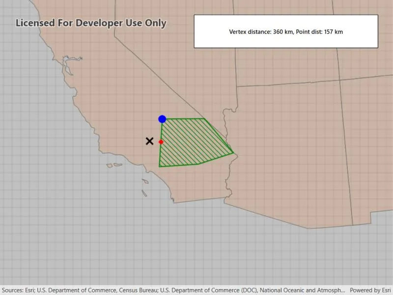
Click anywhere on the map. An orange cross will show at that location. A blue circle will show the polygon’s nearest vertex to the point that was clicked. A red diamond will appear at the coordinate on the geometry that is nearest to the point that was clicked. If clicked inside the geometry, the red and orange markers will overlap. The information box showing distance between the clicked point and the nearest vertex/coordinate will be updated with every new location clicked.
How it works
- Get a
Geometryand aPointto check the nearest vertex against. - Call
inputGeometry.NearestVertex(point). - Use the returned
ProximityResultto get thePointrepresenting the polygon vertex, and to determine the distance between that vertex and the clicked point. - Call
inputGeometry.NearestCoordinate(point). - Use the returned
ProximityResultto get thePointrepresenting the coordinate on the polygon, and to determine the distance between that coordinate and the clicked point.
Relevant API
- GeometryEngine
- ProximityResult
Additional information
The value of ProximityResult.distance is planar (Euclidean) distance. Planar distances are only accurate for geometries that have a defined projected coordinate system, which maintain the desired level of accuracy. The example polygon in this sample is defined in California State Plane Coordinate System - Zone 5 (WKID 2229), which maintains accuracy near Southern California. Accuracy declines outside the state plane zone.
Tags
analysis, coordinate, geometry, nearest, proximity, vertex
Sample code
// Copyright 2020 Esri.//// Licensed under the Apache License, Version 2.0 (the "License"); you may not use this file except in compliance with the License.// You may obtain a copy of the License at: http://www.apache.org/licenses/LICENSE-2.0//// Unless required by applicable law or agreed to in writing, software distributed under the License is distributed on an// "AS IS" BASIS, WITHOUT WARRANTIES OR CONDITIONS OF ANY KIND, either express or implied. See the License for the specific// language governing permissions and limitations under the License.
using Esri.ArcGISRuntime.Geometry;using Esri.ArcGISRuntime.Mapping;using Esri.ArcGISRuntime.Portal;using Esri.ArcGISRuntime.Symbology;using Esri.ArcGISRuntime.UI;using Esri.ArcGISRuntime.UI.Controls;using System;using System.Threading.Tasks;
namespace ArcGIS.WPF.Samples.NearestVertex{    [ArcGIS.Samples.Shared.Attributes.Sample(        name: "Nearest vertex",        category: "Geometry",        description: "Find the closest vertex and coordinate of a geometry to a point.",        instructions: "Click anywhere on the map. An orange cross will show at that location. A blue circle will show the polygon's nearest vertex to the point that was clicked. A red diamond will appear at the coordinate on the geometry that is nearest to the point that was clicked. If clicked inside the geometry, the red and orange markers will overlap. The information box showing distance between the clicked point and the nearest vertex/coordinate will be updated with every new location clicked.",        tags: new[] { "analysis", "coordinate", "geometry", "nearest", "proximity", "vertex" })]    [ArcGIS.Samples.Shared.Attributes.OfflineData("8c2d6d7df8fa4142b0a1211c8dd66903")]    public partial class NearestVertex    {        // Hold references to the graphics overlay and the polygon graphic.        private GraphicsOverlay _graphicsOverlay;        private Graphic _polygonGraphic;
        // Hold references to the graphics for the user and results points.        private Graphic _tappedLocationGraphic;        private Graphic _nearestVertexGraphic;        private Graphic _nearestCoordinateGraphic;
        public NearestVertex()        {            InitializeComponent();
            // Create the map, set the initial extent, and add the original point graphic.            _ = Initialize();        }
        private async Task Initialize()        {            // Planar distances are only accurate for geometries that have a defined projected coordinate system.            // Create a spatial reference using the California zone 5 (ftUS) state plane coordinate system.            // This coordinate system maintains planar distance accuracy in the region of Southern California.            SpatialReference californiaZone5SpatialReference = SpatialReference.Create(2229);
            // Create a map that uses the California zone 5 state spatial reference.            MyMapView.Map = new Map(californiaZone5SpatialReference);
            // Create the feature layer.            ArcGISPortal portal = await ArcGISPortal.CreateAsync();            PortalItem portalItem = await PortalItem.CreateAsync(portal, "8c2d6d7df8fa4142b0a1211c8dd66903");            FeatureLayer usaStatesFeatureLayer = new FeatureLayer(portalItem);
            // Add the feature layer to the MapView.            MyMapView.Map.OperationalLayers.Add(usaStatesFeatureLayer);
            // Create the graphics overlay and set the selection color.            _graphicsOverlay = new GraphicsOverlay();
            // Add the overlay to the MapView.            MyMapView.GraphicsOverlays.Add(_graphicsOverlay);
            // Create the point collection that defines the polygon.            PointCollection polygonPoints = new PointCollection(californiaZone5SpatialReference)            {                new MapPoint(6627416.41469281, 1804532.53233782),                new MapPoint(6669147.89779046, 2479145.16609522),                new MapPoint(7265673.02678292, 2484254.50442408),                new MapPoint(7676192.55880379, 2001458.66365744),                new MapPoint(7175695.94143837, 1840722.34474458)            };
            // Create the polygon.            Polygon polygonGeometry = new Polygon(polygonPoints);
            // Define and apply the symbology.            SimpleLineSymbol polygonOutlineSymbol = new SimpleLineSymbol(SimpleLineSymbolStyle.Solid, System.Drawing.Color.Green, 2);            SimpleFillSymbol polygonFillSymbol = new SimpleFillSymbol(SimpleFillSymbolStyle.ForwardDiagonal, System.Drawing.Color.Green, polygonOutlineSymbol);
            // Create the graphic and add it to the graphics overlay.            _polygonGraphic = new Graphic(polygonGeometry, polygonFillSymbol);            _graphicsOverlay.Graphics.Add(_polygonGraphic);
            // Create the graphics and symbology for the tapped point, the nearest vertex, and the nearest coordinate.            SimpleMarkerSymbol tappedLocationSymbol = new SimpleMarkerSymbol(SimpleMarkerSymbolStyle.X, System.Drawing.Color.Black, 15);            SimpleMarkerSymbol nearestCoordinateSymbol = new SimpleMarkerSymbol(SimpleMarkerSymbolStyle.Diamond, System.Drawing.Color.Red, 10);            SimpleMarkerSymbol nearestVertexSymbol = new SimpleMarkerSymbol(SimpleMarkerSymbolStyle.Circle, System.Drawing.Color.Blue, 15);            _nearestCoordinateGraphic = new Graphic { Symbol = nearestCoordinateSymbol };            _tappedLocationGraphic = new Graphic { Symbol = tappedLocationSymbol };            _nearestVertexGraphic = new Graphic { Symbol = nearestVertexSymbol };
            _graphicsOverlay.Graphics.Add(_tappedLocationGraphic);            _graphicsOverlay.Graphics.Add(_nearestVertexGraphic);            _graphicsOverlay.Graphics.Add(_nearestCoordinateGraphic);
            // Listen for taps; the spatial relationships will be updated in the handler.            MyMapView.GeoViewTapped += MapViewTapped;
            // Center the map on the polygon.            await MyMapView.SetViewpointCenterAsync(polygonGeometry.Extent.GetCenter(), 8000000);        }
        private void MapViewTapped(object sender, GeoViewInputEventArgs geoViewInputEventArgs)        {            // Get the tapped location.            MapPoint tappedLocation = (MapPoint)geoViewInputEventArgs.Location.NormalizeCentralMeridian();
            // Show the tapped location.            _tappedLocationGraphic.Geometry = tappedLocation;
            // Get the nearest vertex in the polygon.            ProximityResult nearestVertexResult = _polygonGraphic.Geometry.NearestVertex(tappedLocation);
            // Get the nearest coordinate in the polygon.            ProximityResult nearestCoordinateResult =                _polygonGraphic.Geometry.NearestCoordinate(tappedLocation);
            // Get the distance to the nearest vertex in the polygon.            int distanceVertex = (int)(nearestVertexResult.Distance / 1000);
            // Get the distance to the nearest coordinate in the polygon.            int distanceCoordinate = (int)(nearestCoordinateResult.Distance / 1000);
            // Show the nearest vertex in blue.            _nearestVertexGraphic.Geometry = nearestVertexResult.Coordinate;
            // Show the nearest coordinate in red.            _nearestCoordinateGraphic.Geometry = nearestCoordinateResult.Coordinate;
// Show the distances in the UI. ResultsLabel.Content = string.Format("Vertex distance: {0} km, Point dist: {1} km", distanceVertex, distanceCoordinate); } }}<UserControl x:Class="ArcGIS.WPF.Samples.NearestVertex.NearestVertex" xmlns="http://schemas.microsoft.com/winfx/2006/xaml/presentation" xmlns:x="http://schemas.microsoft.com/winfx/2006/xaml" xmlns:esri="http://schemas.esri.com/arcgis/runtime/2013"> <Grid> <esri:MapView x:Name="MyMapView" /> <Border Style="{StaticResource BorderStyle}"> <StackPanel> <Label x:Name="ResultsLabel" HorizontalContentAlignment="Center" Content="Tap to see the nearest vertex and point." FontWeight="SemiBold" /> </StackPanel> </Border> </Grid></UserControl>