Project a point from one spatial reference to another.
Use case
Being able to project between spatial references is fundamental to a GIS. An example of when you would need to re-project data is if you had data in two different spatial references, but wanted to perform an intersect analysis with the GeometryEngine.Intersect method. This function takes two geometries as parameters, and both geometries must be in the same spatial reference. If they are not, you could first use GeometryEngine.Project to convert the geometries so they match.
How to use the sample
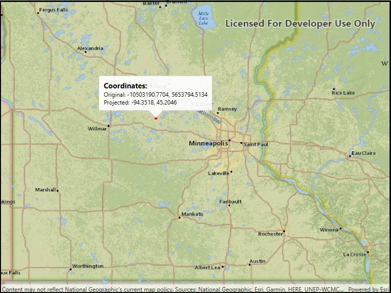
Click anywhere on the map. A callout will display the clicked location’s coordinate in the original (basemap’s) spatial reference and in the projected spatial reference.
How it works
- Call the static extension method,
GeometryEngine.Project, passing in the originalGeometryand aSpatialReferenceto which it should be projected.
Relevant API
- GeometryEngine
- Point
- SpatialReference
Additional information
In cases where the the output spatial reference uses a different geographic coordinate system than that of the input spatial reference, see the GeometryEngine.project method that additionally takes in a DatumTransformation parameter.
Tags
coordinate system, coordinates, latitude, longitude, projected, projection, spatial reference, Web Mercator, WGS 84
Sample code
// Copyright 2019 Esri.//// Licensed under the Apache License, Version 2.0 (the "License"); you may not use this file except in compliance with the License.// You may obtain a copy of the License at: http://www.apache.org/licenses/LICENSE-2.0//// Unless required by applicable law or agreed to in writing, software distributed under the License is distributed on an// "AS IS" BASIS, WITHOUT WARRANTIES OR CONDITIONS OF ANY KIND, either express or implied. See the License for the specific// language governing permissions and limitations under the License.
using Esri.ArcGISRuntime.Geometry;using Esri.ArcGISRuntime.Mapping;using Esri.ArcGISRuntime.Symbology;using Esri.ArcGISRuntime.UI;using Esri.ArcGISRuntime.UI.Controls;using System.Threading.Tasks;using Color = System.Drawing.Color;
namespace ArcGIS.WPF.Samples.Project{    [ArcGIS.Samples.Shared.Attributes.Sample(        name: "Project",        category: "Geometry",        description: "Project a point from one spatial reference to another.",        instructions: "Click anywhere on the map. A callout will display the clicked location's coordinate in the original (basemap's) spatial reference and in the projected spatial reference.",        tags: new[] { "WGS 84", "Web Mercator", "coordinate system", "coordinates", "latitude", "longitude", "projected", "projection", "spatial reference" })]    public partial class Project    {        public Project()        {            InitializeComponent();            _ = Initialize();        }
        private async Task Initialize()        {            // Show a map in the default WebMercator spatial reference.            MyMapView.Map = new Map(BasemapStyle.ArcGISTopographic);
            // Add a graphics overlay for showing the tapped point.            GraphicsOverlay overlay = new GraphicsOverlay();            SimpleMarkerSymbol markerSymbol = new SimpleMarkerSymbol(SimpleMarkerSymbolStyle.Circle, Color.Red, 5);            overlay.Renderer = new SimpleRenderer(markerSymbol);            MyMapView.GraphicsOverlays.Add(overlay);
            // Respond to user taps.            MyMapView.GeoViewTapped += MapView_Tapped;
            // Zoom to Minneapolis.            Envelope startingEnvelope = new Envelope(-10995912.335747, 5267868.874421, -9880363.974046, 5960699.183877,                SpatialReferences.WebMercator);            await MyMapView.SetViewpointGeometryAsync(startingEnvelope);        }
        private void MapView_Tapped(object sender, GeoViewInputEventArgs e)        {            // Get the tapped point - this is in the map's spatial reference,            // which in this case is WebMercator because that is the SR used by the included basemaps.            MapPoint tappedPoint = e.Location;
            // Update the graphics.            MyMapView.GraphicsOverlays[0].Graphics.Clear();            MyMapView.GraphicsOverlays[0].Graphics.Add(new Graphic(tappedPoint));
            // Project the point to WGS84            MapPoint projectedPoint = (MapPoint)tappedPoint.Project(SpatialReferences.Wgs84);
            // Format the results in strings.            string originalCoords = string.Format("Original: {0:F4}, {1:F4}", tappedPoint.X, tappedPoint.Y);            string projectedCoords = string.Format("Projected: {0:F4}, {1:F4}", projectedPoint.X, projectedPoint.Y);            string formattedString = string.Format("{0}\n{1}", originalCoords, projectedCoords);
// Define a callout and show it in the map view. CalloutDefinition calloutDef = new CalloutDefinition("Coordinates:", formattedString); MyMapView.ShowCalloutAt(tappedPoint, calloutDef); } }}<UserControl x:Class="ArcGIS.WPF.Samples.Project.Project" xmlns="http://schemas.microsoft.com/winfx/2006/xaml/presentation" xmlns:x="http://schemas.microsoft.com/winfx/2006/xaml" xmlns:esri="http://schemas.esri.com/arcgis/runtime/2013"> <Grid> <esri:MapView x:Name="MyMapView" /> </Grid></UserControl>