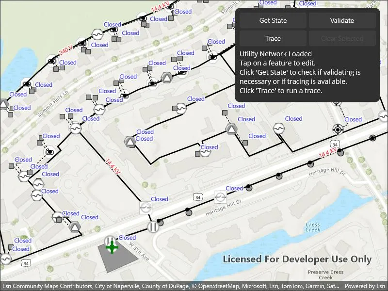
Demonstrates the workflow of getting the network state and validating the topology of a utility network.
Use case
Dirty areas are generated where edits to utility network features have not been evaluated against the network rules. Tracing across this area could result in an error or return inaccurate results. Validating the utility network updates the network topology with the edited feature data, maintaining consistency between the features and topology. Querying the network state allows you to determine if there are dirty areas or errors in a utility network, and if it supports network topology.
How to use the sample
Select features to make edits and then use ‘Update and Apply Edit’ to send edits to the server.
- Tap ‘Get state’ to check if validate is required or if tracing is available.
- Tap ‘Validate’ to validate network topology and clear dirty areas.
- Tap ‘Trace’ to run a trace.
How it works
- Create and load a
Mapwith a web map item URL. - Load the
UtilityNetworkfrom the web map and switch itsServiceGeodatabaseto a new branch version. - Add
LabelDefinitions for the fields that will be updated on a feature edit. - Add the
UtilityNetwork.DirtyAreaTableto the map to visualize dirty areas or errors. - Set a default starting location and trace parameters to stop traversability on an open device.
- Get the
UtilityNetworkCapabilitiesfrom theUtilityNetworkDefinitionand use these values to enable or disable the ‘Get State’, ‘Validate’, and ‘Trace’ buttons. - When an
ArcGISFeatureis selected for editing, populate the choice list for the field value using the field’sCodedValueDomain.CodedValues. - When ‘Update and Apply Edits’ is clicked, update the value of the selected feature’s attribute value with the selected
CodedValue.Codeand callServiceGeodatabase.ApplyEditsAsync(). - When ‘Get State’ is clicked, call
UtilityNetwork.GetStateAsync()and print the results. - When ‘Validate’ is clicked, get the current map extent and call
UtilityNetwork.ValidateNetworkTopology(). - When ‘Trace’ is clicked, call
UtilityNetwork.TraceAsync()with the predefined parameters and select all features returned. - When ‘Clear Selection’ or ‘Cancel’ are clicked, clear all selected features on each layer in the map and close the attribute picker.
Relevant API
- UtilityElement
- UtilityElementTraceResult
- UtilityNetwork
- UtilityNetworkCapabilities
- UtilityNetworkState
- UtilityNetworkValidationJob
- UtilityTraceConfiguration
- UtilityTraceParameters
- UtilityTraceResult
About the data
The Naperville electric feature service contains a utility network that can be used to query the network state and validate network topology before tracing. The Naperville electric webmap uses the same feature service endpoint and is shown in this sample. Authentication is required and handled within the sample code.
Tags
dirty areas, edit, network topology, online, state, trace, utility network, validate
Sample code
// Copyright 2024 Esri.//// Licensed under the Apache License, Version 2.0 (the "License"); you may not use this file except in compliance with the License.// You may obtain a copy of the License at: http://www.apache.org/licenses/LICENSE-2.0//// Unless required by applicable law or agreed to in writing, software distributed under the License is distributed on an// "AS IS" BASIS, WITHOUT WARRANTIES OR CONDITIONS OF ANY KIND, either express or implied. See the License for the specific// language governing permissions and limitations under the License.
using System.Text;using Esri.ArcGISRuntime;using Esri.ArcGISRuntime.ArcGISServices;using Esri.ArcGISRuntime.Data;using Esri.ArcGISRuntime.Geometry;using Esri.ArcGISRuntime.Mapping;using Esri.ArcGISRuntime.Mapping.Labeling;using Esri.ArcGISRuntime.Security;using Esri.ArcGISRuntime.Symbology;using Esri.ArcGISRuntime.UI;using Color = System.Drawing.Color;using Esri.ArcGISRuntime.Maui;using Esri.ArcGISRuntime.UtilityNetworks;
namespace ArcGIS.Samples.ValidateUtilityNetworkTopology{ [ArcGIS.Samples.Shared.Attributes.Sample( name: "Validate utility network topology", category: "Utility network", description: "Demonstrates the workflow of getting the network state and validating the topology of a utility network.", instructions: "Select features to make edits and then use 'Update and Apply Edit' to send edits to the server.", tags: new[] { "dirty areas", "edit", "network topology", "online", "state", "trace", "utility network", "validate" })] [ArcGIS.Samples.Shared.Attributes.OfflineData()] public partial class ValidateUtilityNetworkTopology { private static readonly string WebmapItemUrl = "https://sampleserver7.arcgisonline.com/portal/home/item.html?id=6e3fc6db3d0b4e6589eb4097eb3e5b9b";
private readonly Viewpoint InitialViewpoint = new Viewpoint( new Envelope( -9815489.0660101417, 5128463.4221229386, -9814625.2768726498, 5128968.4911854975, SpatialReferences.WebMercator ) );
// For editing private const string LineTableName = "Electric Distribution Line"; private const string DeviceTableName = "Electric Distribution Device"; private ArcGISFeature _featureToEdit;
// To impact trace private const string DeviceStatusField = "devicestatus";
private readonly LabelDefinition DeviceLabelDefinition = new LabelDefinition( new SimpleLabelExpression($"[{DeviceStatusField}]"), new TextSymbol { Color = Color.Blue, HaloColor = Color.White, HaloWidth = 2, Size = 12 } ) { UseCodedValues = true };
// To better visualize dirty area private const string NominalVoltageField = "nominalvoltage";
private readonly LabelDefinition LineLabelDefinition = new LabelDefinition( new SimpleLabelExpression($"[{NominalVoltageField}]"), new TextSymbol { Color = Color.Red, HaloColor = Color.White, HaloWidth = 2, Size = 12 } ) { UseCodedValues = true };
// For tracing private const string AssetGroupName = "Circuit Breaker"; private const string AssetTypeName = "Three Phase"; private const string GlobalId = "{1CAF7740-0BF4-4113-8DB2-654E18800028}"; private const string DomainNetworkName = "ElectricDistribution"; private const string TierName = "Medium Voltage Radial"; private UtilityTraceParameters _traceParameters;
public ValidateUtilityNetworkTopology() { InitializeComponent(); _ = Initialize(); }
private async Task Initialize() { try { BusyIndicator.IsVisible = true; Status.Text = "Loading a webmap...";
// Add credential for this webmap. // WARNING: Never hardcode login information in a production application. This is done solely for the sake of the sample. string sampleServerPortalUrl = "https://sampleserver7.arcgisonline.com/portal/sharing/rest"; string sampleServer7User = "editor01"; string sampleServer7Pass = "S7#i2LWmYH75"; var credential = await AccessTokenCredential.CreateAsync( new Uri(sampleServerPortalUrl), sampleServer7User, sampleServer7Pass ); AuthenticationManager.Current.AddCredential(credential);
// Load map to access utility network. var map = new Map(new Uri(WebmapItemUrl)) { InitialViewpoint = InitialViewpoint };
// Load in persistent session mode (workaround for server caching issue). // https://support.esri.com/en-us/bug/asynchronous-validate-request-for-utility-network-servi-bug-000160443 map.LoadSettings = new LoadSettings() { FeatureServiceSessionType = FeatureServiceSessionType.Persistent };
MyMapView.Map = map; await map.LoadAsync();
// Load and switch utility network version. Status.Text = "Loading the utility network..."; var utilityNetwork = map.UtilityNetworks.FirstOrDefault() ?? throw new InvalidOperationException("Expected a utility network"); await utilityNetwork.LoadAsync();
var sgdb = utilityNetwork.ServiceGeodatabase ?? throw new InvalidOperationException("Expected a service geodatabase"); BusyIndicator.IsVisible = true;
// Restrict editing and tracing on a random branch. var parameters = new ServiceVersionParameters(); parameters.Name = $"ValidateNetworkTopology_{Guid.NewGuid()}"; parameters.Access = VersionAccess.Private; parameters.Description = "Validate network topology with ArcGIS Runtime";
var info = await sgdb.CreateVersionAsync(parameters); await sgdb.SwitchVersionAsync(info.Name);
// Visualize attribute editing using labels. foreach (var layer in map.OperationalLayers.OfType<FeatureLayer>()) { if (layer.Name == DeviceTableName) { layer.LabelDefinitions.Add(DeviceLabelDefinition); layer.LabelsEnabled = true; } else if (layer.Name == LineTableName) { layer.LabelDefinitions.Add(LineLabelDefinition); layer.LabelsEnabled = true; } }
// Visualize dirty area by adding to the map. var dirtyAreaTable = utilityNetwork.DirtyAreaTable ?? throw new InvalidOperationException("Expected a dirty area table"); MyMapView.Map.OperationalLayers.Insert(0, new FeatureLayer(utilityNetwork.DirtyAreaTable));
// Trace with a subnetwork controller as default starting location. var networkSource = utilityNetwork.Definition.GetNetworkSource(DeviceTableName); var assetGroup = networkSource.GetAssetGroup(AssetGroupName); var assetType = assetGroup.GetAssetType(AssetTypeName); var globalId = Guid.Parse(GlobalId); var startingLocation = utilityNetwork.CreateElement(assetType, globalId); startingLocation.Terminal = startingLocation .AssetType .TerminalConfiguration ?.Terminals .FirstOrDefault(term => term.Name == "Load");
// Display starting location as graphic. var features = await utilityNetwork.GetFeaturesForElementsAsync( new[] { startingLocation } ); var feature = features.FirstOrDefault(); if (feature != null) { await feature.LoadAsync(); var graphic = new Graphic(feature.Geometry) { Symbol = new SimpleMarkerSymbol( SimpleMarkerSymbolStyle.Cross, Color.Green, 25d ) }; var overlay = new GraphicsOverlay(); overlay.Graphics.Add(graphic); MyMapView.GraphicsOverlays.Add(overlay); }
// Trace with a configuration that stops traversability on an open device. var domainNetwork = utilityNetwork.Definition.GetDomainNetwork(DomainNetworkName); var sourceTier = domainNetwork.GetTier(TierName);
_traceParameters = new UtilityTraceParameters( UtilityTraceType.Downstream, new[] { startingLocation } ) { TraceConfiguration = sourceTier.GetDefaultTraceConfiguration() };
// Enable buttons with UtilityNetworkCapabilities. ValidateBtn.IsEnabled = utilityNetwork .Definition .Capabilities .SupportsValidateNetworkTopology; TraceBtn.IsEnabled = utilityNetwork.Definition.Capabilities.SupportsTrace; StateBtn.IsEnabled = utilityNetwork.Definition.Capabilities.SupportsNetworkState; ClearBtn.IsEnabled = false;
// Set the instruction text. Status.Text = "Utility Network Loaded\n" + "Tap on a feature to edit.\n" + "Click 'Get State' to check if validating is necessary " + "or if tracing is available.\n" + "Click 'Trace' to run a trace."; } catch (Exception ex) { Status.Text = "Initialization failed."; await Application.Current.Windows[0].Page.DisplayAlert(ex.Message, ex.GetType().Name, "OK"); } finally { BusyIndicator.IsVisible = false; } }
private async void OnGetState(object sender, EventArgs e) { try { var utilityNetwork = MyMapView?.Map?.UtilityNetworks.FirstOrDefault() ?? throw new InvalidOperationException("Expected a utility network");
if (utilityNetwork.Definition.Capabilities.SupportsNetworkState) { BusyIndicator.IsVisible = true; Status.Text = "Getting utility network state...";
var state = await utilityNetwork.GetStateAsync();
// Validate if dirty areas or errors exist. ValidateBtn.IsEnabled = state.HasDirtyAreas;
// Trace if network topology is enabled. TraceBtn.IsEnabled = state.IsNetworkTopologyEnabled;
var sb = new StringBuilder( "Utility Network State:\n" + $"- Has Dirty Areas: {state.HasDirtyAreas}\n" + $"- Has Errors: {state.HasErrors}\n" + $"- Is Network Topology Enabled: {state.IsNetworkTopologyEnabled}\n" );
if (state.HasDirtyAreas || state.HasErrors) { sb.AppendLine("Click 'Validate' before trace or expect a trace error."); } else { sb.AppendLine("Tap on a feature to edit or click 'Trace' to run a trace."); }
Status.Text = sb.ToString(); } } catch (Exception ex) { await Application.Current.Windows[0].Page.DisplayAlert(ex.GetType().Name, ex.Message, "OK"); } finally { BusyIndicator.IsVisible = false; } }
private async void OnValidate(object sender, EventArgs e) { try { var utilityNetwork = MyMapView?.Map?.UtilityNetworks.FirstOrDefault() ?? throw new InvalidOperationException("Expected a utility network");
// Validate using the current extent. var extent = MyMapView ?.GetCurrentViewpoint(ViewpointType.BoundingGeometry) ?.TargetGeometry ?.Extent ?? throw new InvalidOperationException("Expected current extent");
BusyIndicator.IsVisible = true; Status.Text = "Validating utility network topology...";
// Get the validation result. var job = utilityNetwork.ValidateNetworkTopology(extent); var result = await job.GetResultAsync();
Status.Text = "Utility Validation Result:\n" + $"- Has Dirty Areas: {result.HasDirtyAreas}\n" + $"- Has Errors: {result.HasErrors}\n" + "Click 'Get State' to check the updated network state.";
ValidateBtn.IsEnabled = result.HasDirtyAreas; } catch (Exception ex) { Status.Text = "Validate network topology failed."; await Application.Current.Windows[0].Page.DisplayAlert(ex.GetType().Name, ex.Message, "OK"); } finally { BusyIndicator.IsVisible = false; } }
private async void OnGeoViewTapped(object sender, GeoViewInputEventArgs e) { try { BusyIndicator.IsVisible = true; Status.Text = "Identifying feature to edit...";
// Perform an identify to determine if a user tapped on a feature. var layerResults = await MyMapView.IdentifyLayersAsync(e.Position, 5, false); var feature = layerResults .FirstOrDefault( l => ( l.LayerContent.Name == DeviceTableName || l.LayerContent.Name == LineTableName ) ) ?.GeoElements .FirstOrDefault() as ArcGISFeature; if (feature is null) { Status.Text = "No feature identified. Tap on a feature to edit."; return; }
var updateFieldName = feature.FeatureTable.TableName == DeviceTableName ? DeviceStatusField : NominalVoltageField; var field = feature.FeatureTable.GetField(updateFieldName); var codedValues = (field?.Domain as CodedValueDomain)?.CodedValues; if (field is null || codedValues is null || codedValues.Count == 0) { return; }
if (feature.LoadStatus != LoadStatus.Loaded) { await feature.LoadAsync(); }
_featureToEdit = feature;
// Clear previous selection. MyMapView .Map .OperationalLayers .OfType<FeatureLayer>() .ToList() .ForEach(layer => layer.ClearSelection());
// Select the feature. if (_featureToEdit.FeatureTable.Layer is FeatureLayer featureLayer) featureLayer.SelectFeature(_featureToEdit);
Choices.ItemsSource = (System.Collections.IList)codedValues; var actualValue = Convert.ToInt32(_featureToEdit.Attributes[field.Name]); Choices.SelectedItem = codedValues.Single( c => Convert.ToInt32(c.Code).Equals(actualValue) );
FieldName.Text = field.Name; Status.Text = $"Select a new '{field.Alias ?? field.Name}'";
// Update the UI for the selection. AttributePicker.IsVisible = true; ClearBtn.IsEnabled = true; } catch (Exception ex) { Status.Text = "Identifying feature to edit failed."; await Application.Current.Windows[0].Page.DisplayAlert(ex.GetType().Name, ex.Message, "OK"); } finally { BusyIndicator.IsVisible = false; } }
private async void OnApplyEdits(object sender, EventArgs e) { try { var serviceGeodatabase = ( _featureToEdit?.FeatureTable as ServiceFeatureTable )?.ServiceGeodatabase;
var fieldName = FieldName?.Text?.Trim(); if ( _featureToEdit is null || serviceGeodatabase is null || string.IsNullOrWhiteSpace(fieldName) || !_featureToEdit.Attributes.ContainsKey(fieldName) || !(Choices.SelectedItem is CodedValue codedValue) ) { return; }
BusyIndicator.IsVisible = true;
Status.Text = "Updating feature..."; _featureToEdit.Attributes[fieldName] = codedValue.Code; await _featureToEdit.FeatureTable.UpdateFeatureAsync(_featureToEdit);
Status.Text = "Applying edits..."; var applyEditsResult = await serviceGeodatabase.ApplyEditsAsync();
if ( applyEditsResult.Any( r => r.EditResults.Any(er => er.CompletedWithErrors || er.Error != null) ) ) { Status.Text = "Apply edits completed with error."; } else { Status.Text = "Apply edits completed successfully.\n" + "Click 'Get State' to check the updated network state."; } } catch (Exception ex) { Status.Text = "Apply edits failed."; await Application.Current.Windows[0].Page.DisplayAlert(ex.GetType().Name, ex.Message, "OK"); } finally { // Clear selection. MyMapView .Map .OperationalLayers .OfType<FeatureLayer>() .ToList() .ForEach(layer => layer.ClearSelection());
AttributePicker.IsVisible = false; ClearBtn.IsEnabled = false; ValidateBtn.IsEnabled = true; BusyIndicator.IsVisible = false; } }
private async void OnTrace(object sender, EventArgs e) { var utilityNetwork = MyMapView?.Map?.UtilityNetworks.FirstOrDefault() ?? throw new InvalidOperationException("Expected a utility network");
try { // Update the UI. BusyIndicator.IsVisible = true; Status.Text = $"Running a downstream trace...";
// Clear previous selection from the layers. MyMapView .Map .OperationalLayers .OfType<FeatureLayer>() .ToList() .ForEach(layer => layer.ClearSelection());
// Get the trace result from the utility network. var traceResult = await utilityNetwork.TraceAsync(_traceParameters); var elementTraceResult = traceResult.FirstOrDefault(r => r is UtilityElementTraceResult) as UtilityElementTraceResult;
// Check if there are any elements in the result. var elementsFound = elementTraceResult?.Elements.Count ?? 0; Status.Text = $"Trace completed: {elementsFound} elements found"; foreach (var layer in MyMapView.Map.OperationalLayers.OfType<FeatureLayer>()) { var elements = elementTraceResult .Elements .Where(element => element.NetworkSource.FeatureTable == layer.FeatureTable); if (elements.Any()) { var features = await utilityNetwork.GetFeaturesForElementsAsync(elements); layer.SelectFeatures(features); } }
ClearBtn.IsEnabled = true; } catch (Exception ex) { Status.Text = "Trace failed.\n" + "Click 'Get State' to check the updated network state."; await Application.Current.Windows[0].Page.DisplayAlert(ex.GetType().Name, ex.Message, "OK"); } finally { BusyIndicator.IsVisible = false; } }
private void OnClear(object sender, EventArgs e) { AttributePicker.IsVisible = false;
// Clear the selection. MyMapView .Map .OperationalLayers .OfType<FeatureLayer>() .ToList() .ForEach(layer => layer.ClearSelection());
_featureToEdit = null;
Status.Text = "Selection cleared.";
ClearBtn.IsEnabled = false; } }}<?xml version="1.0" encoding="utf-8" ?><ContentPage x:Class="ArcGIS.Samples.ValidateUtilityNetworkTopology.ValidateUtilityNetworkTopology" xmlns="http://schemas.microsoft.com/dotnet/2021/maui" xmlns:x="http://schemas.microsoft.com/winfx/2009/xaml" xmlns:esri="http://schemas.esri.com/arcgis/runtime/2013" xmlns:esriUI="clr-namespace:Esri.ArcGISRuntime.Maui;assembly=Esri.ArcGISRuntime.Maui"> <Grid Style="{DynamicResource EsriSampleContainer}"> <esriUI:MapView x:Name="MyMapView" GeoViewTapped="OnGeoViewTapped" Style="{DynamicResource EsriSampleGeoView}" /> <Border Style="{DynamicResource EsriSampleControlPanel}"> <Grid x:Name="ControlPanel" ColumnDefinitions="*,*" ColumnSpacing="5" RowDefinitions="auto,auto,auto,auto" RowSpacing="5"> <Button x:Name="StateBtn" Grid.Row="0" Grid.Column="0" Clicked="OnGetState" Text="Get State" /> <Button x:Name="ValidateBtn" Grid.Row="0" Grid.Column="1" Clicked="OnValidate" Text="Validate" /> <Button x:Name="TraceBtn" Grid.Row="1" Grid.Column="0" Clicked="OnTrace" Text="Trace" /> <Button x:Name="ClearBtn" Grid.Row="1" Grid.Column="1" Clicked="OnClear" Text="Clear Selected" /> <Label x:Name="Status" Grid.Row="2" Grid.ColumnSpan="2" Text="Loading sample..." /> <ActivityIndicator x:Name="BusyIndicator" Grid.Row="3" Grid.ColumnSpan="2" Height="15" IsRunning="True" IsVisible="False" /> </Grid> </Border> <Border x:Name="AttributePicker" Grid.RowSpan="2" Grid.ColumnSpan="2" Margin="5" Padding="5" Background="{AppThemeBinding Light=#dfdfdf, Dark=#303030}" HorizontalOptions="Center" IsVisible="False" StrokeShape="RoundRectangle 10, 10, 10, 10" VerticalOptions="Center"> <Grid ColumnDefinitions="Auto,Auto" ColumnSpacing="5" RowDefinitions="Auto,Auto" RowSpacing="5"> <Label x:Name="FieldName" HorizontalTextAlignment="End" VerticalTextAlignment="Center" WidthRequest="170" /> <Picker x:Name="Choices" Grid.Column="1" ItemDisplayBinding="{Binding Name, x:DataType=esri:CodedValue}" WidthRequest="130" /> <Button Grid.Row="1" Clicked="OnApplyEdits" Text="Update and Apply Edit" /> <Button x:Name="CloseButton" Grid.Row="1" Grid.Column="1" Clicked="OnClear" Text="Cancel" /> </Grid> </Border> </Grid></ContentPage>