The utility network is accessed through a combination of services to support utility network workflows. Several service types are used in addition to extending the feature service to support the utility network. These extension services are enabled on the map service by the capabilities that the service will support.
This diagram presents an architectural overview of how your services interact with geodatabases and ArcGIS Enterprise.
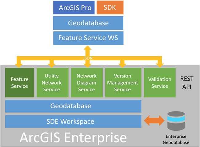
Publishing a utility network dataset enables the Utility Network and Network Diagram services by default:
-
The Utility Network service performs operations such as trace analysis, validating network topology, and updating subnetworks.
-
The Network Diagram service performs all operations related to diagrams, such as creating diagrams and working with layouts.
The Feature service has been extended to recognize utility network concepts such as associations and dirty area management.
The Version Management service provides additional capability to work with and manage branch versioned datasets. This extends the feature service to enable operations such as version creation, reconcile, post, and undo and redo of edits.
The Validation service provides additional capability to support the evaluation of geodatabase rules.
To view the REST endpoints of these services, use the following URLs:
https://<host>/server/rest/services/<service-name>/MapServer
https://<host>/server/rest/services/<service-name>/FeatureServer
https://<host>/server/rest/services/<service-name>/UtilityNetworkServer
https://<host>/server/rest/services/<service-name>/NetworkDiagramServer
https://<host>/server/rest/services/<service-name>/VersionManagementServer
https://<host>/server/rest/services/<service-name>/ValidationServer