Find a route to the closest facility from a location.
Use case
Quickly and accurately determining the most efficient route between a location and a facility is a frequently encountered task. For example, a paramedic may need to know which hospital in the vicinity offers the possibility of getting an ambulance patient critical medical care in the shortest amount of time. Solving for the closest hospital to the ambulance’s location using an impedance of “travel time” would provide this information.
How to use the sample
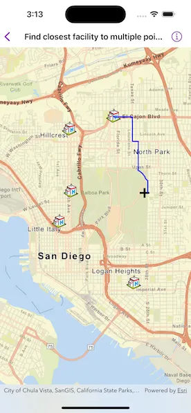
Tap near any of the hospitals and a route will be displayed from that tapped location to the nearest hospital.
How it works
- Create a
ClosestFacilityTaskusing a URL from an online network analysis service. - Get
ClosestFacilityParametersfrom the task,ClosestFacilityTask.makeDefaultParameters(). - Add facilities to the parameters,
ClosestFacilityParameters.setFacilities(_:). - Add an incident to the parameters,
ClosestFacilityParameters.setIncidents(_:). - Get a
ClosestFacilityResultby solving task with parameters,ClosestFacilityTask.solveClosestFacility(using:). - Get the index list of closest facilities to the incident,
ClosestFacilityResult.rankedIndexesOfFacilities(forIncidentAtIndex:). - Get the index of closest facility.
- Find the closest facility route,
ClosestFacilityResult.route(toFacilityAtIndex:fromIncidentAtIndex:). - Display the route on the
MapViewas aGraphicon aGraphicsOverlay.
Relevant API
- ClosestFacilityParameters
- ClosestFacilityResult
- ClosestFacilityRoute
- ClosestFacilityTask
- Facility
- Graphic
- GraphicsOverlay
- Incident
- MapView
Tags
incident, network analysis, route, search
Sample code
FindClosestFacilityToMultiplePointsView.swift
// Copyright 2023 Esri//// Licensed under the Apache License, Version 2.0 (the "License");// you may not use this file except in compliance with the License.// You may obtain a copy of the License at////   https://www.apache.org/licenses/LICENSE-2.0//// Unless required by applicable law or agreed to in writing, software// distributed under the License is distributed on an "AS IS" BASIS,// WITHOUT WARRANTIES OR CONDITIONS OF ANY KIND, either express or implied.// See the License for the specific language governing permissions and// limitations under the License.
import ArcGISimport SwiftUI
struct FindClosestFacilityToMultiplePointsView: View {    /// The view model for the sample.    @StateObject private var model = Model()
    /// The location on the map where the user tapped.    @State private var tapLocation: Point?
    /// The error shown in the error alert.    @State private var error: (any Error)?
    var body: some View {        MapView(            map: model.map,            graphicsOverlays: [model.facilityGraphicsOverlay, model.incidentGraphicsOverlay]        )        .onSingleTapGesture { _, mapPoint in            tapLocation = mapPoint        }        .task(id: tapLocation) {            // Add an incident at the tap location.            guard let tapLocation else { return }
            do {                try await model.updateIncident(to: tapLocation)            } catch {                self.error = error            }        }        .task {            // Set up the closest facility parameters when the sample loads.            do {                try await model.configureClosestFacilityParameters()            } catch {                self.error = error            }        }        .errorAlert(presentingError: $error)    }}
private extension FindClosestFacilityToMultiplePointsView {    /// The view model for the sample.    @MainActor    class Model: ObservableObject {        /// A map with a streets basemap centered on San Diego, CA, USA.        let map = {            let map = Map(basemapStyle: .arcGISStreets)            map.initialViewpoint = Viewpoint(latitude: 32.727, longitude: -117.175, scale: 144_400)            map.maxExtent = .sanDiegoCityLimits            return map        }()
        /// The graphics overlay for the incident graphics.        let incidentGraphicsOverlay = GraphicsOverlay()
        /// The graphics overlay for the facility graphics.        let facilityGraphicsOverlay = GraphicsOverlay()
        /// The task for finding the closest facility.        private let closestFacilityTask = ClosestFacilityTask(url: .sanDiegoNetworkAnalysis)
        /// The parameters to be passed to the task to find the closest facility.        private var closestFacilityParameters: ClosestFacilityParameters?
        /// A list of facilities around San Diego, CA, USA.        private let facilities = {            let facilityPoints = [                Point(x: -13_042_130, y: 3_860_128, spatialReference: .webMercator),                Point(x: -13_042_193, y: 3_862_449, spatialReference: .webMercator),                Point(x: -13_046_883, y: 3_862_705, spatialReference: .webMercator),                Point(x: -13_040_540, y: 3_862_925, spatialReference: .webMercator),                Point(x: -13_042_571, y: 3_858_982, spatialReference: .webMercator),                Point(x: -13_039_785, y: 3_856_693, spatialReference: .webMercator),                Point(x: -13_049_024, y: 3_861_994, spatialReference: .webMercator)            ]            return facilityPoints.map(Facility.init(point:))        }()
        /// The graphic for the route.        private let routeGraphic = Graphic(            symbol: SimpleLineSymbol(style: .solid, color: .blue, width: 2.0)        )
        /// The graphic for the incident.        private let incidentGraphic = Graphic(            symbol: SimpleMarkerSymbol(style: .cross, color: .black, size: 20)        )
        init() {            // Add the incident graphics to the graphics overlay.            incidentGraphicsOverlay.addGraphics([routeGraphic, incidentGraphic])
            // Create graphics for all the facilities and add them to the graphics overlay.            let facilitySymbol = PictureMarkerSymbol(url: .hospitalImage)            facilitySymbol.height = 30            facilitySymbol.width = 30
            let facilityGraphics = facilities.map {                Graphic(geometry: $0.geometry, symbol: facilitySymbol)            }            facilityGraphicsOverlay.addGraphics(facilityGraphics)        }
        /// Creates the closest facility parameters from the closest facility task and the facilities list.        func configureClosestFacilityParameters() async throws {            let parameters = try await closestFacilityTask.makeDefaultParameters()            parameters.setFacilities(facilities)            closestFacilityParameters = parameters        }
        /// Updates the incident to a given point and routes to the closest facility accordingly.        /// - Parameter mapPoint: The point on the map at which to add the incident.        func updateIncident(to mapPoint: Point) async throws {            // Update the incident graphic to the new point.            incidentGraphic.geometry = mapPoint
            // Update the parameters with the new incident.            guard let closestFacilityParameters else { return }
            let incident = Incident(point: mapPoint)            closestFacilityParameters.setIncidents([incident])
            // Get the route to the closest facility.            let closestFacilityRoute = try await routeToClosestFacility(                using: closestFacilityParameters            )
            // Update the route graphic using the result's geometry to display it on the map.            routeGraphic.geometry = closestFacilityRoute?.routeGeometry        }
        /// Gets the route to the closest facility to the incident.        /// - Parameter closestFacilityParameters: The parameters to pass to the closest facility task.        /// - Returns: The route to the closest facility.        private func routeToClosestFacility(            using closestFacilityParameters: ClosestFacilityParameters        ) async throws -> ClosestFacilityRoute? {            // Get the closest facility result from the task using the parameters.            let closestFacilityResult = try await closestFacilityTask.solveClosestFacility(                using: closestFacilityParameters            )
            // Get the ranked list of the closest facility indexes from the result.            let rankedFacilityIndexes = closestFacilityResult.rankedIndexesOfFacilities(                forIncidentAtIndex: 0            )
            // Get the facility index closest to the incident.            guard let closestFacilityIndex = rankedFacilityIndexes.first else { return nil }
            // Get the route for the closest facility and the incident.            return closestFacilityResult.route(                toFacilityAtIndex: closestFacilityIndex,                fromIncidentAtIndex: 0            )        }    }}
private extension URL {    /// The URL to a network analysis server for San Diego, CA, USA on ArcGIS Online.    static var sanDiegoNetworkAnalysis: URL {        URL(string: "https://sampleserver6.arcgisonline.com/arcgis/rest/services/NetworkAnalysis/SanDiego/NAServer/ClosestFacility")!    }
    /// The URL to an image of a hospital symbol on ArcGIS Online.    static var hospitalImage: URL {        URL(string: "https://static.arcgis.com/images/Symbols/SafetyHealth/Hospital.png")!    }}
private extension Envelope {    /// An envelope of the San Diego city limits.    static var sanDiegoCityLimits: Envelope {        Envelope(            xRange: -13_049_024 ... -13_039_785,            yRange: 3_856_693...3_862_925,            spatialReference: .webMercator        )    }}
#Preview {    FindClosestFacilityToMultiplePointsView()}