Geocode addresses to locations and reverse geocode locations to addresses offline.
Use case
You can use an address locator file to geocode addresses and locations. For example, you could provide offline geocoding capabilities to field workers repairing critical infrastructure in a disaster when network availability is limited.
How to use the sample
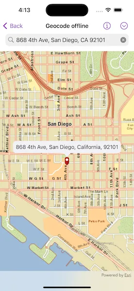
Type the address in the search bar or tap the arrow button in the toolbar and select from the list to geocode the address and view the result on the map. Tap a location to create a pin and reverse geocode. Tap, hold and pan to get real-time geocoding.
How it works
- Use the path of a .loc file to create a
LocatorTaskobject. - Set up
GeocodeParametersand callLocatorTask.geocode(forSearchText:using:)to get geocode results.
Relevant API
- GeocodeParameters
- GeocodeResult
- LocatorTask
- ReverseGeocodeParameters
Offline data
The sample viewer will download offline data automatically before loading the sample.
Tags
geocode, geocoder, locator, offline, package, query, search
Sample code
// Copyright 2023 Esri//// Licensed under the Apache License, Version 2.0 (the "License");// you may not use this file except in compliance with the License.// You may obtain a copy of the License at////   https://www.apache.org/licenses/LICENSE-2.0//// Unless required by applicable law or agreed to in writing, software// distributed under the License is distributed on an "AS IS" BASIS,// WITHOUT WARRANTIES OR CONDITIONS OF ANY KIND, either express or implied.// See the License for the specific language governing permissions and// limitations under the License.
import ArcGISimport SwiftUI
struct GeocodeOfflineView: View {    /// The view model for the sample.    @StateObject private var model = Model()
    /// The viewpoint of the map view, initially centered on San Diego, CA, USA.    @State private var viewpoint = Viewpoint(        center: Point(x: -13_042_250, y: 3_857_970, spatialReference: .webMercator),        scale: 2e4    )
    /// The text in the search bar.    @State private var searchText = ""
    /// The search text that has been submitted.    @State private var submittedSearchText: String?
    /// A Boolean value indicating whether the "No results found." alert is showing.    @State private var resultAlertIsShowing = false
    /// A pre-populated list of example addresses.    private let exampleAddresses = [        "910 N Harbor Dr, San Diego, CA 92101",        "2920 Zoo Dr, San Diego, CA 92101",        "111 W Harbor Dr, San Diego, CA 92101",        "868 4th Ave, San Diego, CA 92101",        "750 A St, San Diego, CA 92101"    ]
    var body: some View {        GeocodeMapView(model: model, viewpoint: $viewpoint)            .searchable(text: $searchText, prompt: "Type in an address")            .autocorrectionDisabled()            .onSubmit(of: .search) {                submittedSearchText = searchText            }            .toolbar {                ToolbarItem(placement: .primaryAction) {                    Menu {                        ForEach(exampleAddresses, id: \.self) { address in                            Button(address) {                                searchText = address                                submittedSearchText = address                            }                        }                    } label: {                        Image(systemName: "chevron.down.circle")                    }                }            }            .onChange(of: searchText) {                // Reset the marker when the search text changes.                model.resetGraphics()            }            .task(id: submittedSearchText) {                // Geocode the text when a search is submitted.                if let submittedSearchText {                    if let resultExtent = await model.geocodeSearch(address: submittedSearchText) {                        // If found, zoom to the extent of the result's location.                        viewpoint = Viewpoint(boundingGeometry: resultExtent)                    } else {                        // If no result was found, inform the user with an alert.                        resultAlertIsShowing = true                    }                }
                submittedSearchText = nil            }            .alert("No results found.", isPresented: $resultAlertIsShowing, actions: {})    }}
private extension GeocodeOfflineView {    /// The map view for the sample.    struct GeocodeMapView: View {        /// The view model for the sample.        @ObservedObject var model: Model
        /// The action that ends the current search interaction.        @Environment(\.dismissSearch) private var dismissSearch
        /// The current viewpoint of the map view.        @Binding var viewpoint: Viewpoint
        /// The point on the map where the user tapped.        @State private var tapLocation: Point?
        var body: some View {            MapView(map: model.map, viewpoint: viewpoint, graphicsOverlays: [model.graphicsOverlay])                .onViewpointChanged(kind: .centerAndScale) { viewpoint = $0 }                .callout(placement: $model.calloutPlacement) { _ in                    Text(model.calloutText)                        .font(.callout)                        .padding(8)                }                .onSingleTapGesture { _, mapPoint in                    tapLocation = mapPoint                }                .onLongPressAndDragGesture { mapPoint in                    model.calloutIsOffset = true                    tapLocation = mapPoint                } onEnded: {                    // Reset the callout's offset when the gesture ends.                    if let tapLocation {                        model.calloutIsOffset = false                        model.updateCalloutPlacement(to: tapLocation)                    }                    tapLocation = nil                }                .task(id: tapLocation) {                    // Reverse geocode the tap location when it changes.                    if let tapLocation {                        dismissSearch()                        await model.reverseGeocode(mapPoint: tapLocation)                    }                }        }    }}
private extension MapView {    /// Sets a closure to perform when the map view recognizes a long press and drag gesture.    /// - Parameters:    ///   - action: The closure to perform when the gesture is recognized.    ///   - onEnded: The closure to perform when the gesture ends.    /// - Returns: A new `View` object.    func onLongPressAndDragGesture(        perform action: @escaping (Point) -> Void,        onEnded: @escaping () -> Void    ) -> some View {        self            .onLongPressGesture { _, mapPoint in                action(mapPoint)            }            .gesture(                LongPressGesture()                    .simultaneously(with: DragGesture())                    .onEnded { _ in                        onEnded()                    }            )    }}
// Copyright 2023 Esri//// Licensed under the Apache License, Version 2.0 (the "License");// you may not use this file except in compliance with the License.// You may obtain a copy of the License at//// https://www.apache.org/licenses/LICENSE-2.0//// Unless required by applicable law or agreed to in writing, software// distributed under the License is distributed on an "AS IS" BASIS,// WITHOUT WARRANTIES OR CONDITIONS OF ANY KIND, either express or implied.// See the License for the specific language governing permissions and// limitations under the License.
import ArcGISimport Combineimport UIKit
extension GeocodeOfflineView { /// The view model for the sample. @MainActor class Model: ObservableObject { // MARK: Properties
/// A map with a tiled layer of the streets in San Diego, CA, USA. let map = { // Create a tiled layer using the local tile package. let tileCache = TileCache(fileURL: .streetMap) let tiledLayer = ArcGISTiledLayer(tileCache: tileCache)
// Create a map with the tiled layer as base layer. return Map(basemap: Basemap(baseLayer: tiledLayer)) }()
/// The graphics overlay for the marker graphic. let graphicsOverlay = GraphicsOverlay()
/// The red map marker graphic used to indicate a given location on the map. private let markerGraphic = { // Create a symbol using the image from the project assets. let markerImage = UIImage.redMarker let markerSymbol = PictureMarkerSymbol(image: markerImage)
// Change the symbol's offsets, so it aligns properly to a given point. markerSymbol.leaderOffsetY = markerImage.size.height / 2 markerSymbol.offsetY = markerImage.size.height / 2
// Create a graphic with the symbol. return Graphic(symbol: markerSymbol) }()
/// The locator task used to preform the geocode operations, loaded from a local file. private let locatorTask = LocatorTask(name: "SanDiego_StreetAddress", bundle: .main)
/// The placement of the callout on the map. @Published var calloutPlacement: CalloutPlacement?
/// A Boolean value indicating whether the callout placement is offset, e.g. when the map magnifier is showing. @Published var calloutIsOffset = false
/// The text shown in the callout. @Published private(set) var calloutText: String = ""
init() { graphicsOverlay.addGraphic(markerGraphic) }
// MARK: Methods
/// Geocodes a given address and adds a marker with the corresponding address at the result's location. /// - Parameter address: The given text address to geocode. /// - Returns: The extent of the result's display location. func geocodeSearch(address: String) async -> Envelope? { guard let locatorTask else { return nil }
// Create geocode parameters. let geocodeParameters = GeocodeParameters() geocodeParameters.addResultAttributeName("Match_addr") geocodeParameters.minScore = 75
// Perform geocode using the locator task with the text address and parameters. let geocodeResults = try? await locatorTask.geocode( forSearchText: address, using: geocodeParameters )
if let result = geocodeResults?.first, let displayLocation = result.displayLocation { // If a result is found, place a marker at the result's location. let resultText = result.attributes["Match_addr"] as? String ?? "" updateMarker(to: displayLocation, withText: resultText)
return displayLocation.extent }
return nil }
/// Reverse geocodes a given location and adds a marker with the corresponding address at the result's location. /// - Parameter mapPoint: The point on the map to reverse geocode. func reverseGeocode(mapPoint: Point) async { guard let locatorTask else { return }
// Normalized the map point. guard let normalizedPoint = GeometryEngine.normalizeCentralMeridian( of: mapPoint ) as? Point else { return }
// Create reverse geocode parameters. let reverseGeocodeParameters = ReverseGeocodeParameters() reverseGeocodeParameters.addResultAttributeName("*") reverseGeocodeParameters.maxResults = 1
// Perform reverse geocode using the locator task with the point and parameters. let geocodeResults = try? await locatorTask.reverseGeocode( forLocation: normalizedPoint, parameters: reverseGeocodeParameters )
let resultText: String if let result = geocodeResults?.first { // If a result is found, extract the address from the attributes. let cityString = result.attributes["City"] as? String ?? "" let streetString = result.attributes["StAddr"] as? String ?? "" let stateString = result.attributes["Region"] as? String ?? ""
resultText = "\(streetString), \(cityString), \(stateString)" } else { resultText = "No address found" }
// Create a marker at the location with the text. updateMarker(to: normalizedPoint, withText: resultText) }
/// Resets the callout and marker graphic, removing them from the map view. func resetGraphics() { calloutPlacement = nil markerGraphic.geometry = nil }
/// Updates the callout placement to a given location. /// - Parameter mapPoint: The point on the map to update the callout placement to. func updateCalloutPlacement(to mapPoint: Point) { if calloutIsOffset { // Offset the callout to the top of the magnifier when it is showing. let magnifierOffset = CGPoint(x: .zero, y: -140) calloutPlacement = .location(mapPoint, offset: magnifierOffset) } else { calloutPlacement = .geoElement(markerGraphic, tapLocation: mapPoint) } }
/// Updates the map marker and its associated callout to a given location. /// - Parameters: /// - mapPoint: The point on the map to move the marker graphic to. /// - text: The text to show in the marker's callout. private func updateMarker(to mapPoint: Point, withText text: String) { markerGraphic.geometry = mapPoint calloutText = text updateCalloutPlacement(to: mapPoint) } }}
private extension URL { /// A URL to the local tile package of the streets in San Diego, CA, USA. static var streetMap: Self { Bundle.main.url(forResource: "streetmap_SD", withExtension: "tpkx")! }}