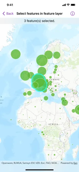
Select features in a feature layer.
Use case
Selecting features, whether by query or identify, can be an important step both in editing data and in visualizing results. One possible use case would be to query a feature layer containing street furniture. A query might look for type “bench” and return a list of bench features contained in the features with an attribute of type bench. These might be selected for further editing or may just be highlighted visually.
How to use the sample
Tap on a feature in the map. All features within a given tolerance (in points) of the tap will be selected.
How it works
- Create a
FeatureLayerinstance from a portal item (feature layer or feature service) and add it to the map’s operational layers. - Create instances of
MapViewReaderandMapView. - Asynchronously identify nearby features at the tapped location from the map view using the
MapViewProxy.identify(layer:screenPoint:tolerance:maximumResults:)method. - Select all identified features in the feature layer with
FeatureLayer.select(features:).
Relevant API
- Feature
- FeatureLayer
- MapViewProxy
- MapViewReader
About the data
This sample uses the Gross Domestic Product Per Capita, 1960-2016 feature service. Only the 2016 GDP values are shown.
Tags
features, layers, select, selection, tolerance
Sample code
SelectFeaturesInFeatureLayerView.swift
// Copyright 2022 Esri//// Licensed under the Apache License, Version 2.0 (the "License");// you may not use this file except in compliance with the License.// You may obtain a copy of the License at////   https://www.apache.org/licenses/LICENSE-2.0//// Unless required by applicable law or agreed to in writing, software// distributed under the License is distributed on an "AS IS" BASIS,// WITHOUT WARRANTIES OR CONDITIONS OF ANY KIND, either express or implied.// See the License for the specific language governing permissions and// limitations under the License.
import ArcGISimport SwiftUI
struct SelectFeaturesInFeatureLayerView: View {    /// The selected features.    @State private var selectedFeatures: [Feature] = []
    /// The point indicating where to identify features.    @State private var identifyPoint: CGPoint?
    /// The error shown in the error alert.    @State private var error: (any Error)?
    /// The view model for the sample.    @StateObject private var model = Model()
    var body: some View {        MapViewReader { mapViewProxy in            MapView(map: model.map)                .onSingleTapGesture { screenPoint, _ in                    identifyPoint = screenPoint                }                .task(id: identifyPoint) {                    guard let identifyPoint = identifyPoint else { return }
                    do {                        // Unselects the selected features.                        model.gdpPerCapitaLayer.unselectFeatures(selectedFeatures)
                        // Saves the results from the identify method on the map view proxy.                        let results = try await mapViewProxy.identify(                            on: model.gdpPerCapitaLayer,                            screenPoint: identifyPoint,                            tolerance: 12,                            maximumResults: 10                        )
                        // Updates the selected features to the geo elements from the results.                        selectedFeatures = results.geoElements as! [Feature]
                        // Selects the features from the selected features array.                        model.gdpPerCapitaLayer.selectFeatures(selectedFeatures)                    } catch {                        // Updates the error and shows an alert.                        self.error = error                    }                }                .overlay(alignment: .top) {                    Text("\(selectedFeatures.count) feature(s) selected.")                        .frame(maxWidth: .infinity)                        .padding(.vertical, 6)                        .background(.thinMaterial, ignoresSafeAreaEdges: .horizontal)                }                .errorAlert(presentingError: $error)        }    }}
private extension SelectFeaturesInFeatureLayerView {    /// The model used to store the geo model and other expensive objects    /// used in this view.    class Model: ObservableObject {        /// A feature layer visualizing GDP per capita.        let gdpPerCapitaLayer = FeatureLayer(            item: PortalItem(                portal: .arcGISOnline(connection: .anonymous),                id: .gdpPerCapita            )        )
        /// A map with a topographic basemap style and a feature layer.        let map: Map
        init() {            map = Map(basemapStyle: .arcGISTopographic)            map.addOperationalLayer(gdpPerCapitaLayer)        }    }}
private extension PortalItem.ID {    static var gdpPerCapita: Self { Self("10d76a5b015647279b165f3a64c2524f")! }}
#Preview {    SelectFeaturesInFeatureLayerView()}