Display a WMS layer using a WMS service URL.
Use case
WMS is an OGC standard for displaying maps from images that are dynamically-generated on a web server. WMS is particularly useful for data that changes frequently, contains cartographically complex detail, or requires an open source data standard.
How to use the sample
The map will load automatically when the sample starts.
How it works
- Create a
WMSLayerspecifying the URL of the service and the names of layers you want to display.- Note: The name comes from the
Nameproperty, not theTitleproperty. On many services, the title is human-readable while the name is a numeric identifier.
- Note: The name comes from the
- Add the layer to the map as an operational layer.
Relevant API
- Map
- MapView
- WMSLayer
About the data
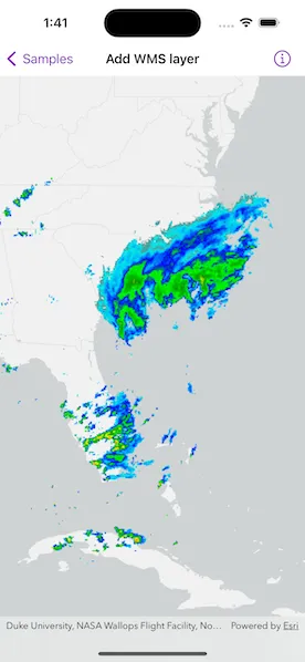
This sample uses the WMS service behind the U.S. National Weather Service radar map. Because WMS services generate map images on-the-fly, this layer is always up-to-date with the latest NOAA nowCOAST real-time coastal observations, forecasts and warnings.
Tags
OGC, web map service
Sample code
AddWMSLayerView.swift
// Copyright 2023 Esri//// Licensed under the Apache License, Version 2.0 (the "License");// you may not use this file except in compliance with the License.// You may obtain a copy of the License at////   https://www.apache.org/licenses/LICENSE-2.0//// Unless required by applicable law or agreed to in writing, software// distributed under the License is distributed on an "AS IS" BASIS,// WITHOUT WARRANTIES OR CONDITIONS OF ANY KIND, either express or implied.// See the License for the specific language governing permissions and// limitations under the License.
import ArcGISimport SwiftUI
struct AddWMSLayerView: View {    /// A map with light gray basemap centered on the USA.    @State private var map: Map = {        let map = Map(basemapStyle: .arcGISLightGrayBase)
        // Center the map on the United States.        map.initialViewpoint = Viewpoint(            latitude: 39, longitude: -98, scale: 4e7        )
        // A URL to a weather radar WMS service.        let wmsServiceURL = URL(string: "https://nowcoast.noaa.gov/geoserver/observations/weather_radar/wms")!
        // The names of the layers to load at the WMS service.        let wmsServiceLayerNames = ["conus_base_reflectivity_mosaic"]
        // Initialize the WMS layer with the service URL and uniquely identifying        // WMS layer names.        let wmsLayer = WMSLayer(url: wmsServiceURL, layerNames: wmsServiceLayerNames)
        // Add the WMS layer to the map's operational layers.        map.addOperationalLayer(wmsLayer)        return map    }()
    var body: some View {        // Create a map view to display the map.        MapView(map: map)    }}
#Preview {    AddWMSLayerView()}