Display annotation from a feature service URL.
Use case
Annotation is useful for displaying text that you don’t want to move or resize when the map is panned or zoomed (unlike labels which will move and resize). You can use annotation to place text at a fixed size, position, orientation, font, and so on. You may choose to do this for cartographic reasons or because the exact placement of the text is important.
How to use the sample
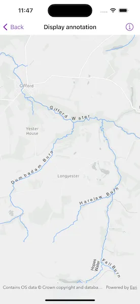
Pan and zoom to see names of waters and burns in a small region of Scotland.
How it works
- Create an
Mapwith a light gray canvas and a viewpoint near the data. - Create an
FeatureLayerfrom a feature service URL. - Create an
AnnotationLayerfrom a feature service URL. - Add both layers to the operational layers of the map and add it to a
MapView.
Relevant API
- AnnotationLayer
- FeatureLayer
About the data
Data derived from the OS Open Rivers dataset from Ordnance Survey . Contains OS data © Crown copyright and database right 2018.
The annotation layer contains two sublayers of rivers in East Lothian, Scotland, which were set by the author to only be visible within the following scale ranges:
- Water (1:50,000 - 1:100,000) - A large stream, as defined in the Scots language
- Burn (1:25,000 - 1:75,000) - A brook or small stream, as defined in the Scots language
Additional information
Annotation is only supported from feature services hosted on ArcGIS Enterprise.
Tags
annotation, cartography, labels, placement, reference scale, text, utility
Sample code
// Copyright 2023 Esri//// Licensed under the Apache License, Version 2.0 (the "License");// you may not use this file except in compliance with the License.// You may obtain a copy of the License at////   https://www.apache.org/licenses/LICENSE-2.0//// Unless required by applicable law or agreed to in writing, software// distributed under the License is distributed on an "AS IS" BASIS,// WITHOUT WARRANTIES OR CONDITIONS OF ANY KIND, either express or implied.// See the License for the specific language governing permissions and// limitations under the License.
import ArcGISimport SwiftUI
struct DisplayAnnotationView: View {    /// A map with a light grey basemap centered on East Lothian in Scotland.    @State private var map: Map = {        let map = Map(basemapStyle: .arcGISLightGray)        map.initialViewpoint = Viewpoint(latitude: 55.882436, longitude: -2.725610, scale: 72_223.819286)        return map    }()
    /// The error shown in the error alert.    @State private var error: (any Error)?
    var body: some View {        // Create a map view with a map.        MapView(map: map)            .task {                do {                    // Create a feature layer.                    let featureTable = ServiceFeatureTable(url: .eastLothianRivers)                    try await featureTable.load()                    let featureLayer = FeatureLayer(featureTable: featureTable)
                    // Create an annotation layer.                    let annotationLayer = AnnotationLayer(url: .riversAnnotation)                    try await annotationLayer.load()
                    // Add both layers to the map as operational layers.                    map.addOperationalLayers([featureLayer, annotationLayer])                } catch {                    // Present an alert for an error loading a layer.                    self.error = error                }            }            .errorAlert(presentingError: $error)    }}
private extension URL {    /// A URL to a feature layer for the rivers in East Lothian.    static var eastLothianRivers: URL {        URL(string: "https://services1.arcgis.com/6677msI40mnLuuLr/arcgis/rest/services/East_Lothian_Rivers/FeatureServer/0")!    }
    /// A URL to an annotation layer for the rivers in East Lothian.    static var riversAnnotation: URL {        URL(string: "https://sampleserver6.arcgisonline.com/arcgis/rest/services/RiversAnnotation/FeatureServer/0")!    }}
#Preview {    DisplayAnnotationView()}